Expert Forecasts for the 2024 NATL Hurricane Season

This is the general tropical discussion area. Anyone can take their shot at predicting a storms path.

Moderator: S2k Moderators

Forum rules

The posts in this forum are NOT official forecasts and should not be used as such. They are just the opinion of the poster and may or may not be backed by sound meteorological data. They are NOT endorsed by any professional institution or STORM2K. For official information, please refer to products from the National Hurricane Center and National Weather Service.

Help Support Storm2K
Message
Author
User avatar
toad strangler
S2K Supporter
S2K Supporter
Posts: 4543
Joined: Sun Jul 28, 2013 3:09 pm
Location: Earth
Contact:

Re: Expert Forecasts for the 2024 NATL Hurricane Season: CSU extensive discussion about the 2024 season

#321 Postby toad strangler » Wed Sep 04, 2024 12:51 pm

Ubuntwo wrote:
Bigtenfan wrote:I agree that it is too harsh criticism of the CSU people.

That said: This came up on another board. How did CSU become the be all to end all of seasonal hurricane forecasting as opposed to say the University of Miami which is a stone's throw from the NHC? To me that is like UM being the forecaster for snowy New England winters.

Dr. William M. Gray I believe is the answer to your question.


Indeed it is Dr. William Gray of CSU. The tropical seasonal forecasting OG
0 likes   

User avatar
Teban54
Category 5
Category 5
Posts: 3168
Joined: Sat May 19, 2018 1:19 pm

Re: Expert Forecasts for the 2024 NATL Hurricane Season: CSU extensive discussion about the 2024 season

#322 Postby Teban54 » Wed Sep 04, 2024 12:57 pm

Emmett_Brown wrote:The position and strength of the monsoon trough, the upper level temperatures of the tropopause and their affect on atmospheric stability (maybe a solar cycle component to this?), the "too much of a good thing" easterly shear in the eastern Atlantic, and the influence of MJO will all likely get more weight in future years long range hurricane forecasts. I'm thankful that they published their thoughts about how the season is going so that we can all learn. It takes guts for them to own when their forecasts don't go perfectly, so kudos to them.

It will be fascinating to watch how the remainder of this potentially explosive season unfolds.

How many of these could have been expected much earlier in advance between April and August when CSU issues their forecasts, though? (Not a rhetorical question, just bringing it up for discussion.)

The only thing that I felt was apparent from climate models was the +NAO. But I don't think it had ever been discussed as being detrimental to tropical activity; it was usually in the context of track patterns.
0 likes   

User avatar
Teban54
Category 5
Category 5
Posts: 3168
Joined: Sat May 19, 2018 1:19 pm

Re: Expert Forecasts for the 2024 NATL Hurricane Season: CSU extensive discussion about the 2024 season

#323 Postby Teban54 » Wed Sep 04, 2024 1:07 pm

tolakram wrote:
MGC wrote:Just read CSU latest discussion on the progress of or lack thereof of the 2024 hurricane season. Lots of excuses, kind of like having your 5 year old explain why he ate all the cookies. IMO they are going to BUST big time....we are talking epic bust. Really, they think end of September, October and November are now going to be hyper active? I have my doubts. While it is possible the odds are long IMO. I'm thinking maybe 12-14 named systems total this season. Lets just hope they are all fish and we don't see a deadly landfall......MGC


I think that's too harsh, especially since every agency is going to bust, but just my opinion. I note he explicitly stated they are not changing their forecast at this time. That might seem a bit off but scientifically they don't have any solid reasoning for a slow season, just guesses, so their forecast stands. It will be interesting to see if they buckle and lower even though there is no solid evidence that works with their hindcasting. If they do change then what does that say about their methodology? CSU is in the un envious position of having a theory they are testing.

Also (related to the bolded part), I vaguely recall that in 2013, by around mid-September, Phil Klotzbach essentially admitted on Twitter (?) that their forecasts would bust. That was my recollection from looking at some 2013 threads on Storm2K, but I don't remember that exactly, nor had I seen the original note myself when it happened. Someone else is free to dig it up if they're interested.

Here's what CSU said for 2024 in their discussion yesterday. It does sound like they have lowered their thresholds to "potential" for a "hyperactive season" (>159.6 ACE) rather than the original 230 ACE forecast, though. Applying ACE from the following years from September 10 onwards would allow us to reach hyperactive ACE: 1967, 1998, 1999, 2004, 2005, 2017, and 2020.
So at this point, while it would be highly unlikely for CSU’s seasonal hurricane forecasts to exactly verify, there is still potential that a hyperactive season could be reached. Of course, the season is quiet at the moment with no immediate indications of a rapid rampup. CSU will be extensively monitoring large-scale conditions throughout the remainder of the season and will include additional extensive discussion in its end-of-the-year verification issued on 26 November.
2 likes   

Bigtenfan
Tropical Wave
Tropical Wave
Posts: 8
Joined: Sun Aug 18, 2024 8:25 am

Re: Expert Forecasts for the 2024 NATL Hurricane Season: CSU extensive discussion about the 2024 season

#324 Postby Bigtenfan » Wed Sep 04, 2024 1:39 pm

toad strangler wrote:
Ubuntwo wrote:
Bigtenfan wrote:I agree that it is too harsh criticism of the CSU people.

That said: This came up on another board. How did CSU become the be all to end all of seasonal hurricane forecasting as opposed to say the University of Miami which is a stone's throw from the NHC? To me that is like UM being the forecaster for snowy New England winters.

Dr. William M. Gray I believe is the answer to your question.


Indeed it is Dr. William Gray of CSU. The tropical seasonal forecasting OG


True but he has been dead something like 8 years now. IIRC he was the senior professor of atmospheric sciences. I thought that when he passed CSU would cease to be the most quoted tropical forecast.
0 likes   

USTropics
Category 5
Category 5
Posts: 2635
Joined: Sun Aug 12, 2007 3:45 am
Location: Florida State University

Re: Expert Forecasts for the 2024 NATL Hurricane Season: CSU extensive discussion about the 2024 season

#325 Postby USTropics » Wed Sep 04, 2024 2:19 pm

Bigtenfan wrote:
toad strangler wrote:
Ubuntwo wrote:Dr. William M. Gray I believe is the answer to your question.


Indeed it is Dr. William Gray of CSU. The tropical seasonal forecasting OG


True but he has been dead something like 8 years now. IIRC he was the senior professor of atmospheric sciences. I thought that when he passed CSU would cease to be the most quoted tropical forecast.


Dr. Gray basically pioneered seasonal forecasting of the Atlantic hurricane season, and Dr. Klotzbach is second to none in his knowledge of seasonal hurricane forecasting. People can throw shade all they want on seasonal forecasts for this season, but really it only shows how much more we can improve and what new features/factors there are to analyze. Our reanalysis only goes back to 150 years (satellite era began in the 1960s), and if you consider the oceans formed about 3.8 billion years ago, theoretically we can analyze 0.0000036% of possible hurricane seasons. It's a computer science oriented field, but there is still a significant amount we don't know that future meteorologists will learn (for instance, research on ITF and Atlantic Nino/equatorial mode are pretty nuance and within the last ~10-20 years).
5 likes   

User avatar
SFLcane
S2K Supporter
S2K Supporter
Posts: 10162
Age: 47
Joined: Sat Jun 05, 2010 1:44 pm
Location: Lake Worth Florida

Re: Expert Forecasts for the 2024 NATL Hurricane Season: CSU extensive discussion about the 2024 season

#326 Postby SFLcane » Wed Sep 04, 2024 2:34 pm

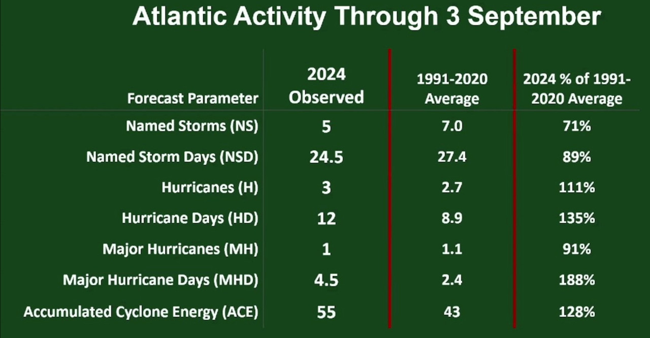
Watch Phil k discuss his new outlook and what we might expect the rest of the season. Great Discussion! https://hurricanecenterlive.com

Image
1 likes   

LarryWx
Category 5
Category 5
Posts: 6246
Joined: Sun Sep 07, 2003 2:04 pm
Location: GA

Re: Expert Forecasts for the 2024 NATL Hurricane Season: CSU extensive discussion about the 2024 season

#327 Postby LarryWx » Wed Sep 04, 2024 2:41 pm

Teban54 wrote:
Emmett_Brown wrote:The position and strength of the monsoon trough, the upper level temperatures of the tropopause and their affect on atmospheric stability (maybe a solar cycle component to this?), the "too much of a good thing" easterly shear in the eastern Atlantic, and the influence of MJO will all likely get more weight in future years long range hurricane forecasts. I'm thankful that they published their thoughts about how the season is going so that we can all learn. It takes guts for them to own when their forecasts don't go perfectly, so kudos to them.

It will be fascinating to watch how the remainder of this potentially explosive season unfolds.

How many of these could have been expected much earlier in advance between April and August when CSU issues their forecasts, though? (Not a rhetorical question, just bringing it up for discussion.)

The only thing that I felt was apparent from climate models was the +NAO. But I don't think it had ever been discussed as being detrimental to tropical activity; it was usually in the context of track patterns.


Teban,
The NOAA NAO will probably come in within +0.4-+0.75. So, while Aug overall will come in + due to the last half, it wasn’t unusually + as 16 Augs were more + since 1950.

Regardless, I decided to look at Aug/Sep activity for seasons when August NAOs were >+1 (when JAS RONI wasn’t at a moderate or stronger Nino level) to see if I could detect a possible significant correlation between strongly +NAO in Aug and quieter than climo. I couldn’t. Here’s why:

1) 1955 (Niña) +1.07: Aug very active with 3H incl MH Connie; Sep also very active with 5H incl 3MH

2) 1967 +1.44: Aug very quiet but Sept active with 3H including MH Beulah

3) 1971 +1.55: Aug moderate activity; Sep very active including 4H, with one MH

4) 1976 +1.92: Aug very active with 4H including MH Belle; Sep active with 3H including 1 MH

5) 1983 +1.76: Aug active with 2H including MH Alicia; Sep pretty quiet

6) 1984 +1.15: Aug quiet; Sep active with 2H including MH Diana

7) 1991 +1.23: Aug only 1 NS but it was MH Bob; Sep 3 NS including MH Claudette

8) 1996 +1.02: Aug active with 3H including MH Edouard; Sep very active with 4 MH

9) 2018 +1.97: Aug quiet; Sep active with 3H including MH Florence

10) 2022 (Niña) +1.47: Aug very quiet (no NS); Sep very active with 4H including 2 MH

——————

So for the above 10 seasons (that weren’t mod to strong El Niño) with strong Aug +NAO, here’s the summary as compared to longterm climo:

-Aug: 4 were quiet, 2 had moderate activity, and 4 were active. So, Aug was balanced as compared to climo.

-Sep: only one was quiet (1983), one had moderate activity (1991), and 8 were active.

-In summary regarding the 10 seasons with a strong Aug +NAO: none were shut down in both Aug and Sep, Aug was balanced between quiet and active, and Sep was actually mainly active! Thus, I see no discernible correlation between a +NAO in August and reduced hurricane activity in Aug/Sep.

Monthly NAO 1950+: https://www.cpc.ncep.noaa.gov/products/ ... scii.table

*This post would be better placed in the “Late Aug/Early Sep” thread but I wanted to reply to Teban’s reference to +NAO.
***(Aside: S2K is having major problems. Just getting in takes much longer than normal. Sometimes I get an error message and don’t get in. Now suddenly it’s working fine. But there have been good periods like this between bad periods.)

*Also, I made a donation 2 days ago and posted about it. But I’ve yet to receive a confirmation.
Last edited by LarryWx on Wed Sep 04, 2024 2:45 pm, edited 1 time in total.
1 likes   
Personal Forecast Disclaimer:
The posts in this forum are NOT official forecasts and should not be used as such. They are just the opinion of the poster and may or may not be backed by sound meteorological data. They are NOT endorsed by any professional institution or storm2k.org. For official information, please refer to the NHC and NWS products.

User avatar
SFLcane
S2K Supporter
S2K Supporter
Posts: 10162
Age: 47
Joined: Sat Jun 05, 2010 1:44 pm
Location: Lake Worth Florida

Re: Expert Forecasts for the 2024 NATL Hurricane Season: CSU extensive discussion about the 2024 season

#328 Postby SFLcane » Wed Sep 04, 2024 2:45 pm

SFLcane wrote:Watch Phil k discuss his new outlook and what we might expect the rest of the season. Great Discussion! https://hurricanecenterlive.com

https://i.postimg.cc/kgGHC7WH/ggg.jpg


Image
0 likes   

User avatar
chaser1
S2K Supporter
S2K Supporter
Posts: 5406
Age: 64
Joined: Sat Oct 15, 2005 5:59 pm
Location: Longwood, Fl

Re: Expert Forecasts for the 2024 NATL Hurricane Season: CSU extensive discussion about the 2024 season

#329 Postby chaser1 » Wed Sep 04, 2024 3:46 pm

Teban54 wrote:
Emmett_Brown wrote:The position and strength of the monsoon trough, the upper level temperatures of the tropopause and their affect on atmospheric stability (maybe a solar cycle component to this?), the "too much of a good thing" easterly shear in the eastern Atlantic, and the influence of MJO will all likely get more weight in future years long range hurricane forecasts. I'm thankful that they published their thoughts about how the season is going so that we can all learn. It takes guts for them to own when their forecasts don't go perfectly, so kudos to them.

It will be fascinating to watch how the remainder of this potentially explosive season unfolds.

How many of these could have been expected much earlier in advance between April and August when CSU issues their forecasts, though? (Not a rhetorical question, just bringing it up for discussion.)

The only thing that I felt was apparent from climate models was the +NAO. But I don't think it had ever been discussed as being detrimental to tropical activity; it was usually in the context of track patterns.


That's an excellent question..... IF you accept the premise. So,

1) one can possibly glean that CSU (and ALL) other agencies are blind to the potential combination of mitigating factors such as strong easterly shear, monsoonal troughs, MJO influence and ENSO conditions while putting all of their betting chips on very warm SST's and an expected NINA. I don't buy this at all. :na: Sure, some of these factors might not have been predictable and simply out of view but would have CSU or other agencies have weighted those factors so heavily against otherwise bullish forecast conditions?

Minus the influence of an El Nino and with the anticipated onset of La Nina conditions, I believe that CSU did anticipate strong Easterlies. That didn't seem to prevent Beryl or Ernesto from developing. I do not believe that CSU assesses the MJO as an overriding factor given otherwise favorable conditions, but moreso a factor that might enhance genesis when in a favorable position to do so. I doubt that the development or location of the African monsoon could have been predicted early on. Even if a strong African monsoon could have been predicted, I don't believe for a moment that professional forecast services would have said "hold everything and forget all other factors because this will cause the Atlantic to likely see no more than 10-12 named storms". JUST NO. The African monsoon could deflect the trajectories of better developed areas of vorticity from the northern axis of westward African tropical waves. In fact, haven't we seen years where multiple TS's form in the far Eastern Atlantic and immediately turn to the northwest or poleward? Where were they this year? What about those tropical waves that did continue moving westward and exhibited points of vorticity either within the ITCZ further west, or other disturbances that NHC is presently tracking? What about the development of frontal lows with baroclinic origins that begin to deepen and take on sub-tropical characteristics? The African monsoonal trough could well have changed the trajectory of some far East Atlantic developing tropical cyclones and plausibly impacted the quantity of viable Atlantic MDR development opportunities but as such would be far too insignificant to alter many other tropical systems from eventually developing further west or originating from the west Atlantic basin.

2) Simply not accept CSU's own Tropical Update notes that attempt to site the multitude of different factors that inexplicably occurred so perfectly as to otherwise shut down the most active 30 days of the Atlantic basin and potentially result in a predicted overactive season, to end underactive. I can appreciate the weight of CSU to respond to the many questioning their prediction and provide some logical explanation to the season's outcome thus far. Honestly though, I think that they are still at a loss to really know and will be better equipped to understand with a bit more time and research following season end.

One factor that may have gone unnoticed or hardly taken into account may be the potential impact caused by excessive warming of the tropopause. At this point we are still grappling with whether this was an overriding cause or even playing a role in this season's output. The only other factor that I do believe might have been a factor was humidity and dry air which was not even addressed in CSU's forecast notes update. Outside of obvious SAL outbreaks, I still contend that some upper level of capping continues to be a mitigating condition, and I am eager to learn whether ongoing analysis is able to prove or disprove this. Whether this is a factor of upper atmosphere warming or a separate dry layer that in tandem with a warm upper layer warming I have no idea.

You touched on the impact from a +NAO and I do wonder if this was a factor unable to be properly predicted early on, and perhaps did have some significant impact to this season as was the case during 2013?? I don't remember but how early did forecast models become apparent that positive NAO conditions would be in place for the heart of the season?
3 likes   
Andy D

(For official information, please refer to the NHC and NWS products.)

caneman
Category 5
Category 5
Posts: 1446
Joined: Fri Sep 05, 2014 5:44 am
Location: Clearwater Beach, Fl

Re: Expert Forecasts for the 2024 NATL Hurricane Season: CSU extensive discussion about the 2024 season

#330 Postby caneman » Wed Sep 04, 2024 5:44 pm

So many times we all talk about how these systems are a way to release all the built up energy, heat etc. I can tell you that here in the Tampa Bay region we have had more rain and ferious storms than I can ever remember. Mother nature has found a way to release that energy on us.
1 likes   

User avatar
Hypercane_Kyle
Category 5
Category 5
Posts: 3344
Joined: Sat Mar 07, 2015 7:58 pm
Location: Cape Canaveral, FL

Re: Expert Forecasts for the 2024 NATL Hurricane Season: CSU extensive discussion about the 2024 season

#331 Postby Hypercane_Kyle » Wed Sep 04, 2024 6:31 pm

caneman wrote:So many times we all talk about how these systems are a way to release all the built up energy, heat etc. I can tell you that here in the Tampa Bay region we have had more rain and ferious storms than I can ever remember. Mother nature has found a way to release that energy on us.


Funny you say that, because here on the east coast of Florida it's been pretty dry.
1 likes   
My posts are my own personal opinion, defer to the National Hurricane Center (NHC) and other NOAA products for decision making during hurricane season.

User avatar
wxman57
Moderator-Pro Met
Moderator-Pro Met
Posts: 22950
Age: 67
Joined: Sat Jun 21, 2003 8:06 pm
Location: Houston, TX (southwest)

Re: Expert Forecasts for the 2024 NATL Hurricane Season: CSU extensive discussion about the 2024 season

#332 Postby wxman57 » Wed Sep 04, 2024 6:48 pm

Bigtenfan wrote:
toad strangler wrote:
Ubuntwo wrote:Dr. William M. Gray I believe is the answer to your question.


Indeed it is Dr. William Gray of CSU. The tropical seasonal forecasting OG


True but he has been dead something like 8 years now. IIRC he was the senior professor of atmospheric sciences. I thought that when he passed CSU would cease to be the most quoted tropical forecast.


It was April of 2016. I was at the National Tropical Hurricane Conference in S. Padre Island. I was sitting with Phil Klotzbach when he got the call that Dr. Gray had died. It was a sad day. I first met Dr. Gray at the National Hurricane Conference in Miami in 2004. Dr. Gray was the pioneer in seasonal forecasting. I believe he got the idea after studying El Nino and west coast storm systems in 1982-1983. I first met Phil at one of the hurricane conferences a few years later, when he was a doctoral student. Phil spoke at a couple of our hurricane conferences. I remember in 2010 while attending the AMS tropical conference in Tucson, AZ that he, Bill Read (former NHC director) and I took a car to a grocery store for food supplies for the week to avoid paying the high hotel prices. I think I ate all week for $15. Lots of memories of Dr. Gray at the various conferences. I think I'll attend the NTWC next April. I missed last year. Was just talking with Phil this morning. I told him he should keep that picture of eating crow ready to open his outlooks next spring. ;-)
7 likes   

caneman
Category 5
Category 5
Posts: 1446
Joined: Fri Sep 05, 2014 5:44 am
Location: Clearwater Beach, Fl

Re: Expert Forecasts for the 2024 NATL Hurricane Season: CSU extensive discussion about the 2024 season

#333 Postby caneman » Wed Sep 04, 2024 10:11 pm

Hypercane_Kyle wrote:
caneman wrote:So many times we all talk about how these systems are a way to release all the built up energy, heat etc. I can tell you that here in the Tampa Bay region we have had more rain and ferious storms than I can ever remember. Mother nature has found a way to release that energy on us.


Funny you say that, because here on the east coast of Florida it's been pretty dry.


If anyone cares to they can go to Paul Dellgatto's Facebook page to check out flooding pictures. He's a Tampa Bay area meteorologist. It's been torrential day in and day out. The storms just train and backfill. Every day for a few hours it drops rain like we're in a tropical storm. It's crazy and thunder and lightning are like nothing I can ever recall. Some good videos on Mike's weather facebook page as well.
3 likes   

Dean_175
Category 1
Category 1
Posts: 313
Joined: Mon Oct 17, 2011 1:34 pm

Re: Expert Forecasts for the 2024 NATL Hurricane Season: CSU extensive discussion about the 2024 season

#334 Postby Dean_175 » Sun Sep 08, 2024 8:55 pm

caneman wrote:
Hypercane_Kyle wrote:
caneman wrote:So many times we all talk about how these systems are a way to release all the built up energy, heat etc. I can tell you that here in the Tampa Bay region we have had more rain and ferious storms than I can ever remember. Mother nature has found a way to release that energy on us.


Funny you say that, because here on the east coast of Florida it's been pretty dry.


If anyone cares to they can go to Paul Dellgatto's Facebook page to check out flooding pictures. He's a Tampa Bay area meteorologist. It's been torrential day in and day out. The storms just train and backfill. Every day for a few hours it drops rain like we're in a tropical storm. It's crazy and thunder and lightning are like nothing I can ever recall. Some good videos on Mike's weather facebook page as well.


Sometimes significant events can stick out in memory more. We got some heavy rain on Wednesday and a flash flooding episode. Other than that, I was actually wondering why it seems we have seen less Tstorms this summer. To me, it feels like a drier than usual summer save for Debby and the Wednesday storm.

I remember years where it would go from sunny to torrential multiple times in the day. I havent seen that so far.
0 likes   
All posts by Dean_175 are NOT official forecasts and should not be used as such. They are just the opinion of the poster and may or may not be backed by sound meteorological data. They are NOT endorsed by any professional institution or storm2k.org. For official information, please refer to the NHC and NWS products.

caneman
Category 5
Category 5
Posts: 1446
Joined: Fri Sep 05, 2014 5:44 am
Location: Clearwater Beach, Fl

Re: Expert Forecasts for the 2024 NATL Hurricane Season: CSU extensive discussion about the 2024 season

#335 Postby caneman » Mon Sep 09, 2024 5:07 am

Dean_175 wrote:
caneman wrote:
Hypercane_Kyle wrote:
Funny you say that, because here on the east coast of Florida it's been pretty dry.


If anyone cares to they can go to Paul Dellgatto's Facebook page to check out flooding pictures. He's a Tampa Bay area meteorologist. It's been torrential day in and day out. The storms just train and backfill. Every day for a few hours it drops rain like we're in a tropical storm. It's crazy and thunder and lightning are like nothing I can ever recall. Some good videos on Mike's weather facebook page as well.


Sometimes significant events can stick out in memory more. We got some heavy rain on Wednesday and a flash flooding episode. Other than that, I was actually wondering why it seems we have seen less Tstorms this summer. To me, it feels like a drier than usual summer save for Debby and the Wednesday storm.

I remember years where it would go from sunny to torrential multiple times in the day. I havent seen that so far.


Where are you located? Many areas throughout the Tampa bay area are above norms.
1 likes   

TampaWxLurker
Tropical Depression
Tropical Depression
Posts: 95
Joined: Thu Aug 01, 2024 8:20 am

Re: Expert Forecasts for the 2024 NATL Hurricane Season: CSU extensive discussion about the 2024 season

#336 Postby TampaWxLurker » Mon Sep 09, 2024 7:16 am

caneman wrote:
Dean_175 wrote:
caneman wrote:
If anyone cares to they can go to Paul Dellgatto's Facebook page to check out flooding pictures. He's a Tampa Bay area meteorologist. It's been torrential day in and day out. The storms just train and backfill. Every day for a few hours it drops rain like we're in a tropical storm. It's crazy and thunder and lightning are like nothing I can ever recall. Some good videos on Mike's weather facebook page as well.


Sometimes significant events can stick out in memory more. We got some heavy rain on Wednesday and a flash flooding episode. Other than that, I was actually wondering why it seems we have seen less Tstorms this summer. To me, it feels like a drier than usual summer save for Debby and the Wednesday storm.

I remember years where it would go from sunny to torrential multiple times in the day. I havent seen that so far.


Where are you located? Many areas throughout the Tampa bay area are above norms.


In the Tampa area myself and can confirm we're way, way above norms this year. One of the rainiest rainy season around here in a decade+.
1 likes   

Dean_175
Category 1
Category 1
Posts: 313
Joined: Mon Oct 17, 2011 1:34 pm

Re: Expert Forecasts for the 2024 NATL Hurricane Season: CSU extensive discussion about the 2024 season

#337 Postby Dean_175 » Mon Sep 09, 2024 9:26 am

caneman wrote:
Dean_175 wrote:
caneman wrote:
If anyone cares to they can go to Paul Dellgatto's Facebook page to check out flooding pictures. He's a Tampa Bay area meteorologist. It's been torrential day in and day out. The storms just train and backfill. Every day for a few hours it drops rain like we're in a tropical storm. It's crazy and thunder and lightning are like nothing I can ever recall. Some good videos on Mike's weather facebook page as well.


Sometimes significant events can stick out in memory more. We got some heavy rain on Wednesday and a flash flooding episode. Other than that, I was actually wondering why it seems we have seen less Tstorms this summer. To me, it feels like a drier than usual summer save for Debby and the Wednesday storm.

I remember years where it would go from sunny to torrential multiple times in the day. I havent seen that so far.


Where are you located? Many areas throughout the Tampa bay area are above norms.


St. Pete. Relocated from Fort Myers end of July. I grew up in St. Pete though and also lived in Tampa at one point. 2019 and 2015 were the rainiest summers in this region that I can recall. But recollection is not very accurate. Though in 2015, I distinctly remember Busch Gardens Tampa closing due to excessive rain. It felt like a solid month of non-stop rainy weather and/or clouded conditions. People started complaining about how rainy it was. But that rain came in seemingly constant sprinkles and rarely a sudden downpour. Therefore, flash flooding was less of an issue.
1 likes   
All posts by Dean_175 are NOT official forecasts and should not be used as such. They are just the opinion of the poster and may or may not be backed by sound meteorological data. They are NOT endorsed by any professional institution or storm2k.org. For official information, please refer to the NHC and NWS products.

User avatar
Teban54
Category 5
Category 5
Posts: 3168
Joined: Sat May 19, 2018 1:19 pm

Re: Expert Forecasts for the 2024 NATL Hurricane Season

#338 Postby Teban54 » Mon Sep 16, 2024 5:51 pm

CSU's next two-week forecast should come tomorrow (September 17), according to their schedule. I'm very surprised that not only was it not brought up in this thread, but Phil Klotzbach hasn't even tweeted about it yet.
0 likes   

User avatar
Spacecoast
Category 2
Category 2
Posts: 758
Joined: Thu Aug 31, 2017 2:03 pm

Re: Expert Forecasts for the 2024 NATL Hurricane Season

#339 Postby Spacecoast » Tue Sep 17, 2024 10:31 am

Reviewing CSU's Sept 3rd forecast, It looks like their 60% Below-Normal of <10 ACE proved to be correct.
Observed for that period looks be ~5.9 ACE.

Image

Perhaps they should adapt quintiles, instead of terciles, ...
adding Very-Above-Normal, and Very-Below-Normal.
0 likes   

User avatar
chaser1
S2K Supporter
S2K Supporter
Posts: 5406
Age: 64
Joined: Sat Oct 15, 2005 5:59 pm
Location: Longwood, Fl

Re: Expert Forecasts for the 2024 NATL Hurricane Season

#340 Postby chaser1 » Tue Sep 17, 2024 11:32 am

Just a curious thought/question. Are budgets for Hurricane Season Recon created each year or are they established for multiple years in advance? The reason for the question is that I wonder whether CSU (or any other agency) plays a role or influences how much funds will be needed to satisfy NHC's recon needs for each upcoming season. I have to believe that recon related flight crew, fuel, plane maintenance, and all other related costs for the 2024 season are likely to come in well under budget for the present hurricane season. Hopefully that won't negatively impact allocating ample funds for 2025.
1 likes   
Andy D

(For official information, please refer to the NHC and NWS products.)


Return to “Talkin' Tropics”

Who is online

Users browsing this forum: cycloneye, jconsor, Stormybajan and 93 guests