2024 Global Model Runs Discussion (Out thru day 16)

This is the general tropical discussion area. Anyone can take their shot at predicting a storms path.

Moderator: S2k Moderators

Forum rules

The posts in this forum are NOT official forecasts and should not be used as such. They are just the opinion of the poster and may or may not be backed by sound meteorological data. They are NOT endorsed by any professional institution or STORM2K. For official information, please refer to products from the National Hurricane Center and National Weather Service.

Help Support Storm2K
Message
Author
User avatar
NDG
S2K Supporter
S2K Supporter
Posts: 15446
Joined: Sun Jul 09, 2006 10:14 pm
Location: Orlando, FL

Re: 2024 Global Model Runs Discussion (Out thru day 16)

#1681 Postby NDG » Tue Sep 03, 2024 8:26 pm

Both 18z GFS and 12z Euro agree on lots ofshear across the northern gulf in the 6-10 day range, if not longer. Really early for this much shear if you ask me especially during a -ENSO.
Wxman57 is probably happy about this.

Image
Image
0 likes   

otowntiger
Category 5
Category 5
Posts: 1921
Joined: Tue Aug 31, 2004 7:06 pm

Re: 2024 Global Model Runs Discussion (Out thru day 16)

#1682 Postby otowntiger » Wed Sep 04, 2024 4:39 am

Lots of folks on here complaining that the models are really struggling this year. They may be to some degree in that on occasion they incorrectly try to spin something up only to drop it very quickly. I can see the reason to complain about the inconsistency but the models on the whole are not and have not been predicting any development over the last month or so and they have been correct. They are still predicting no development over the next 2-3 weeks. We are about to zoom past the peak of the season with nothing developing and we are headed toward one the biggest season prediction busts of all time. What’s most interesting about that is no one knows seems to know why. I think at this point the NATL basin will be hard pressed to get to 10 named storms by seasons end.
4 likes   

IsabelaWeather
Category 1
Category 1
Posts: 287
Age: 35
Joined: Tue Jul 07, 2020 7:29 am
Location: Isabela, Puerto Rico

Re: 2024 Global Model Runs Discussion (Out thru day 16)

#1683 Postby IsabelaWeather » Wed Sep 04, 2024 11:49 am

txwxwatcher wrote:
Nuno wrote:
DunedinDave wrote:
I agree. I know we have a lot of people I disagree with here but I’m good with a map showing no storms up through Sept 10. Our local meteorologist was talking about the season last night and said he was surprised at the lack of activity approaching peak day.


I mean, it's not "any"casting, this is a forum of amateur and professional weather trackers and enthusiasts. Nothing wrong with being mystified by cyclones and wanting to see development in the open ocean to scratch the tracking itch. So weird that people come here and make comments as if everyone wants a category 5 to hit a populated area. Car accident victims don't go to race tracks and shame racing fans because of the risk of a crash during the race :lol:

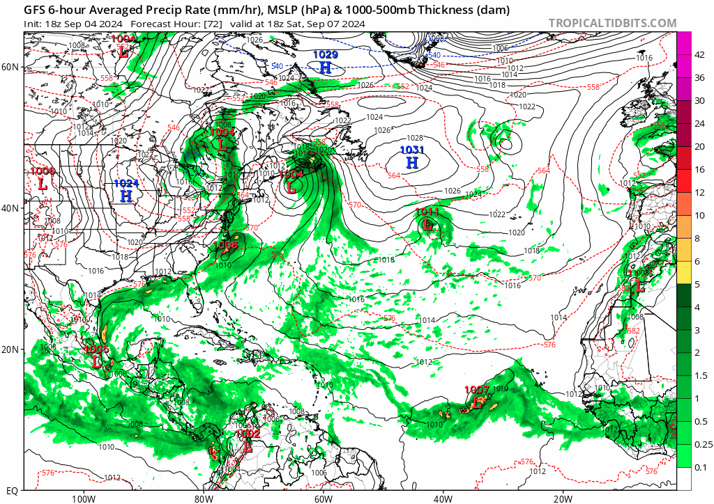
On topic, I see that 12z ICON near the islands. 12z GFS is running on tidbits and for once it's not destroying convection off Africa. :lol:

https://twitter.com/ATCTropics/status/1827735372366778784?t=opr9iRIuaZzOXMJ4s-DHxw&s=19


You can spin it however you would like, but there’s really no way to defend referring to a map showing no tropical activity as “grim.”


Not sure what your problem is, Ill say it. I want to see some powerful hurricanes out there. I think they are incredibly fascinating, obviously I don't want to see destruction or loss of life.

Also, here in PR we get about half of our yearly rain from tropical systems as well, and while they do cause problems, they are also very important for the natural environment and are incredible to track on satellite.

Bullish me has now written off this year though, models show practically nothing. I don't think Ive ever seen it so dead out there.
3 likes   

Stratton23
Category 5
Category 5
Posts: 2513
Joined: Fri Jul 21, 2023 10:59 pm
Location: Katy, Tx

Re: 2024 Global Model Runs Discussion (Out thru day 16)

#1684 Postby Stratton23 » Wed Sep 04, 2024 11:56 am

Well we still got a long ways to go, besides one we get to october we should get the typical CAG setup as activity focuses in the caribbean at that point, i still do not think the basin is going to go the rest of the season without a couple more bamed storms though
0 likes   

User avatar
chaser1
S2K Supporter
S2K Supporter
Posts: 5464
Age: 64
Joined: Sat Oct 15, 2005 5:59 pm
Location: Longwood, Fl

Re: 2024 Global Model Runs Discussion (Out thru day 16)

#1685 Postby chaser1 » Wed Sep 04, 2024 12:25 pm

otowntiger wrote:Lots of folks on here complaining that the models are really struggling this year. They may be to some degree in that on occasion they incorrectly try to spin something up only to drop it very quickly. I can see the reason to complain about the inconsistency but the models on the whole are not and have not been predicting any development over the last month or so and they have been correct. They are still predicting no development over the next 2-3 weeks. We are about to zoom past the peak of the season with nothing developing and we are headed toward one the biggest season prediction busts of all time. What’s most interesting about that is no one knows seems to know why. I think at this point the NATL basin will be hard pressed to get to 10 named storms by seasons end.


Your entire post pretty much nails it. The models (including their ensembles) have not been unduly struggling this year - the atmosphere has. Multiple theories have been offered up and perhaps at some point looking back, we'll then be able to comfortably say "so, THAT's why the season underperformed". The question then will be, will that knowledge advance our forecasting capacity, or will the science continue to lack the ability (or data) to foresee large scale variables impacting tropical development over an entire ocean basin or hemisphere? No different than before, the global models will suddenly "wake up" showing consistent forecast of some developing tropical disturbance. It won't signify the models are beginning to perform as engineered. It'll simply mean that the atmosphere appears to be responding to more conducive conditions. Whether that occurs in a week, a month, or next year really is anyone's guess.
0 likes   
Andy D

(For official information, please refer to the NHC and NWS products.)

User avatar
cheezyWXguy
Category 5
Category 5
Posts: 6108
Joined: Mon Feb 13, 2006 12:29 am
Location: Dallas, TX

Re: 2024 Global Model Runs Discussion (Out thru day 16)

#1686 Postby cheezyWXguy » Wed Sep 04, 2024 12:28 pm

12z gfs pumps out like 5 lows off that stalled front on the east coast, including one in the BOC and also has 2 cv systems. Nothing very strong, but seems like a general indicator that it thinks activity will probably start picking up in the mid-late period.
0 likes   

DunedinDave
Tropical Storm
Tropical Storm
Posts: 227
Joined: Fri Aug 25, 2023 10:31 am

Re: 2024 Global Model Runs Discussion (Out thru day 16)

#1687 Postby DunedinDave » Wed Sep 04, 2024 12:36 pm

ICON looks like it is trying to spin a Hurricane in the Gulf and move it due east, which is an unusual movement for a hurricane in that area. Storms in the Gulf usually like to move W, N, or even NE but not due east.
0 likes   

User avatar
chaser1
S2K Supporter
S2K Supporter
Posts: 5464
Age: 64
Joined: Sat Oct 15, 2005 5:59 pm
Location: Longwood, Fl

Re: 2024 Global Model Runs Discussion (Out thru day 16)

#1688 Postby chaser1 » Wed Sep 04, 2024 12:55 pm

cheezyWXguy wrote:12z gfs pumps out like 5 lows off that stalled front on the east coast, including one in the BOC and also has 2 cv systems. Nothing very strong, but seems like a general indicator that it thinks activity will probably start picking up in the mid-late period.


I am skeptical. I mean you could be right but we will not know otherwise until genesis verifies. Beyond that, the only thing that could tip us off might be some forecast model signals akin to a blaring horn rather than the similar vague and muted signals of one or more weak low pressure. Two or more global models shouting tropical storm development for repetitive model runs would be the type of signal (to me) signifying an actual potential of development. Whether that merely occurs on a short 48-72 hr. fuse or projected 5-8 days away, this would be what i'd be keeping an eye out for. Under normal conditions more subtle cues such as an increase in ensembles "pinging" WOULD be a possible tell-tale sign that tropical development is increasingly likely. Not now however. A bevy of ensemble forecast 1010mb lows does not a tropical depression make. Cooking Analogy: Until we better grasp what's wrong with the recipe, the observation of how many small chunks of mean in the pot will remain inconsequential.
0 likes   
Andy D

(For official information, please refer to the NHC and NWS products.)

MarioProtVI
Category 4
Category 4
Posts: 935
Age: 24
Joined: Sun Sep 29, 2019 7:33 pm
Location: New Jersey

Re: 2024 Global Model Runs Discussion (Out thru day 16)

#1689 Postby MarioProtVI » Wed Sep 04, 2024 5:42 pm

GFS, EURO, CMC and ICON all agree on a strong wave moving off next Tuesday, and all but the CMC (which strings it out) have it developing into a storm and moving basically due west. Seems like the TUTT and MT are gone by then, so this could possibly be a chance for the Atlantic to make up some serious ground with a long-tracker, IF it forms and conditions are decent. Euro ensembles also have a signal for it that’s slowly sinking south though it’s partially influenced by its land-TC bias.

Edit: GFS actually makes this a full-blown MDR hurricane by day 10. Not really a one-off either, it’s been flip flopping between nothing and a MDR hurricane at similar timeframes in the past several runs. Worth watching.
3 likes   

User avatar
Hypercane_Kyle
Category 5
Category 5
Posts: 3352
Joined: Sat Mar 07, 2015 7:58 pm
Location: Cape Canaveral, FL

Re: 2024 Global Model Runs Discussion (Out thru day 16)

#1690 Postby Hypercane_Kyle » Wed Sep 04, 2024 6:37 pm

18z GFS run is almost certainly a ghost storm.
0 likes   
My posts are my own personal opinion, defer to the National Hurricane Center (NHC) and other NOAA products for decision making during hurricane season.

User avatar
Teban54
Category 5
Category 5
Posts: 3204
Joined: Sat May 19, 2018 1:19 pm

Re: 2024 Global Model Runs Discussion (Out thru day 16)

#1691 Postby Teban54 » Wed Sep 04, 2024 6:51 pm

Hypercane_Kyle wrote:18z GFS run is almost certainly a ghost storm.

I mean, we've had weeks without any GFS phantom storms*, and even today people were still commenting on how dead the models are (and how they somehow must remain correct on that). 3 "phantoms" in the last 6 runs do seem like something, either for entertainment value (that GFS is back to the phantom-spinning model that we know) or a weak signal that conditions may be turning more favorable.

* Other than the Caribbean wave (back when every model was showing it) and any of the NHC AOIs (which were mostly weak on those runs, and which probably did have a chance at developing), if you wish.

MarioProtVI wrote:GFS, EURO, CMC and ICON all agree on a strong wave moving off next Tuesday, and all but the CMC (which strings it out) have it developing into a storm and moving basically due west. Seems like the TUTT and MT are gone by then, so this could possibly be a chance for the Atlantic to make up some serious ground with a long-tracker, IF it forms and conditions are decent. Euro ensembles also have a signal for it that’s slowly sinking south though it’s partially influenced by its land-TC bias.

Edit: GFS actually makes this a full-blown MDR hurricane by day 10. Not really a one-off either, it’s been flip flopping between nothing and a MDR hurricane at similar timeframes in the past several runs. Worth watching.

There's also a very weak trend on the last 2-3 GEFS runs in both having more members show a weak low and tracking further south when emerging from Africa.

That said, a few reasons to remain skeptical:
  • This run (18z 9/4) develops a different wave than the last two developing runs (6z 9/4 and 18z 9/3). Those two runs show the strong hurricane from the monsoon trough breakdown of the current mess in Eastern Atlantic, whereas now it's developing the 9/10 wave. (However, this may still indicate that conditions are more conducive for a well-organized disturbance to become strong.)
  • All the developing runs are 6z and 18z, which are generally considered less reliable than 0z and 12z.
  • While today's 12z and 18z runs show the TUTT mostly gone by 9/13 when this wave enters the picture, earlier runs still show the TUTT lingering around until 9/17 or so. Whether that's a correction, uncertainty, or just wonky stuff, who knows.
  • Vastly different tracks on this GFS run (moving due west and scraping Lesser Antilles) vs. Euro runs (recurve near 35-40W).
Image
1 likes   

User avatar
Hurricaneman
Category 5
Category 5
Posts: 7350
Age: 45
Joined: Tue Aug 31, 2004 3:24 pm
Location: central florida

Re: 2024 Global Model Runs Discussion (Out thru day 16)

#1692 Postby Hurricaneman » Wed Sep 04, 2024 7:17 pm

I don’t think the 18zGFS is showing a phantom it comes from the wave in Niger currently and the 12zEuro kind of has this area develop some too so it might be the one to watch as the pattern flips more favorable during the next 10 days into October
1 likes   

User avatar
cheezyWXguy
Category 5
Category 5
Posts: 6108
Joined: Mon Feb 13, 2006 12:29 am
Location: Dallas, TX

Re: 2024 Global Model Runs Discussion (Out thru day 16)

#1693 Postby cheezyWXguy » Wed Sep 04, 2024 9:17 pm

chaser1 wrote:
cheezyWXguy wrote:12z gfs pumps out like 5 lows off that stalled front on the east coast, including one in the BOC and also has 2 cv systems. Nothing very strong, but seems like a general indicator that it thinks activity will probably start picking up in the mid-late period.


I am skeptical. I mean you could be right but we will not know otherwise until genesis verifies. Beyond that, the only thing that could tip us off might be some forecast model signals akin to a blaring horn rather than the similar vague and muted signals of one or more weak low pressure. Two or more global models shouting tropical storm development for repetitive model runs would be the type of signal (to me) signifying an actual potential of development. Whether that merely occurs on a short 48-72 hr. fuse or projected 5-8 days away, this would be what i'd be keeping an eye out for. Under normal conditions more subtle cues such as an increase in ensembles "pinging" WOULD be a possible tell-tale sign that tropical development is increasingly likely. Not now however. A bevy of ensemble forecast 1010mb lows does not a tropical depression make. Cooking Analogy: Until we better grasp what's wrong with the recipe, the observation of how many small chunks of mean in the pot will remain inconsequential.

Yeah at this point I don’t view the current model storms as an indicator that they’re locking in on a specific storm signal yet, just an indicator that the basin is likely to start becoming more favorable in general. There is very little run to run consistency at the moment whether we’re looking at deterministic or ensemble guidance. The cv storm might be the start of something but I’d be more inclined to hold my breath with a more concentrated ensemble signal
2 likes   

User avatar
Teban54
Category 5
Category 5
Posts: 3204
Joined: Sat May 19, 2018 1:19 pm

Re: 2024 Global Model Runs Discussion (Out thru day 16)

#1694 Postby Teban54 » Thu Sep 05, 2024 12:02 am

The 9/10 wave that becomes a major near Lesser Antilles is still on 0z GFS.
0 likes   

User avatar
Woofde
Category 1
Category 1
Posts: 479
Joined: Tue Jul 06, 2021 11:33 am

Re: 2024 Global Model Runs Discussion (Out thru day 16)

#1695 Postby Woofde » Thu Sep 05, 2024 1:27 am

Teban54 wrote:The 9/10 wave that becomes a major near Lesser Antilles is still on 0z GFS.
Rather weak ensemble support for it though. The image is from the same time frame as when the deterministic has it ripping through the Lesser Antilles. A few members support it, but the large majority don't.

I actually can't believe how dead the GFS ensembles are for the basin as a whole through 300 hours.Image
0 likes   

User avatar
Blown Away
S2K Supporter
S2K Supporter
Posts: 10145
Joined: Wed May 26, 2004 6:17 am

Re: 2024 Global Model Runs Discussion (Out thru day 16)

#1696 Postby Blown Away » Thu Sep 05, 2024 7:09 am

Image

If the upper level conditions were not unfavorable we can clearly see how the hyper active season would have played out...
3 likes   
Hurricane Eye Experience: David 79, Irene 99, Frances 04, Jeanne 04, Wilma 05... EYE COMING MY WAY IN 2024…
Hurricane Brush Experience: Andrew 92, Erin 95, Floyd 99, Matthew 16, Irma 17, Ian 22, Nicole 22…

User avatar
Hypercane_Kyle
Category 5
Category 5
Posts: 3352
Joined: Sat Mar 07, 2015 7:58 pm
Location: Cape Canaveral, FL

Re: 2024 Global Model Runs Discussion (Out thru day 16)

#1697 Postby Hypercane_Kyle » Thu Sep 05, 2024 7:12 am

Teban54 wrote:The 9/10 wave that becomes a major near Lesser Antilles is still on 0z GFS.


And, to no surprise, 06z drops it.
1 likes   
My posts are my own personal opinion, defer to the National Hurricane Center (NHC) and other NOAA products for decision making during hurricane season.

User avatar
REDHurricane
Category 1
Category 1
Posts: 396
Age: 27
Joined: Sun Jul 03, 2022 2:36 pm
Location: Northeast Pacific Ocean

Re: 2024 Global Model Runs Discussion (Out thru day 16)

#1698 Postby REDHurricane » Thu Sep 05, 2024 7:49 am

Blown Away wrote:[url]https://i.postimg.cc/tgB908Kx/NHC-8am.jpg [/url]

If the upper level conditions were not unfavorable we can clearly see how the hyper active season would have played out...


Would have? It's only September 5 and there are still 86 days left in the official hurricane season... a lot can happen in 86 days, especially when conditions appear to be set up favorably for possible late-September/early October MDR systems as well as Caribbean shenanigans through October and November. The MJO forcing currently allowing the WPAC to produce the strongest TC of the year so far worldwide and then likely an even stronger one right behind it can and will shift back over to the Atlantic at some point. Whatever weird sh!t is going on this season that's keeping the lid on the Atlantic basin is liable to change at any moment, and there's more than enough time for that to happen where it ends up meeting the hyperactive season threshold anyway -- doesn't seem super likely right now obviously, but it's still likely enough to not talk about this season in past tense already lol
Last edited by REDHurricane on Thu Sep 05, 2024 7:53 am, edited 1 time in total.
3 likes   

MarioProtVI
Category 4
Category 4
Posts: 935
Age: 24
Joined: Sun Sep 29, 2019 7:33 pm
Location: New Jersey

Re: 2024 Global Model Runs Discussion (Out thru day 16)

#1699 Postby MarioProtVI » Thu Sep 05, 2024 7:51 am

Hypercane_Kyle wrote:
Teban54 wrote:The 9/10 wave that becomes a major near Lesser Antilles is still on 0z GFS.


And, to no surprise, 06z drops it.

Of course it did. 2024 can’t have a good thing for more then a day before it’s snatched away.
0 likes   

DunedinDave
Tropical Storm
Tropical Storm
Posts: 227
Joined: Fri Aug 25, 2023 10:31 am

Re: 2024 Global Model Runs Discussion (Out thru day 16)

#1700 Postby DunedinDave » Thu Sep 05, 2024 7:54 am

REDHurricane wrote:
Blown Away wrote:[url]https://i.postimg.cc/tgB908Kx/NHC-8am.jpg [/url]

If the upper level conditions were not unfavorable we can clearly see how the hyper active season would have played out...


Would have? It's only September 5 and there are still 86 days left in the official hurricane season... a lot can happen in 86 days, especially when conditions appear to be set up favorably for possible late-September/early October MDR systems as well as Caribbean shenanigans through October and November. The MJO forcing currently allowing the WPAC to produce the strongest TC of the year so far worldwide and then likely an even stronger one right behind it can and will shift back over at some point. Whatever weird sh!t is going on this season that's keeping the lid on the Atlantic is liable to change at any moment, and there's more than enough time for that to happen where it ends up meeting the hyperactive season threshold anyway -- doesn't seem super likely right now, but it's still likely enough to not talk about this season in past tense already lol


Once cold fronts start sweeping through Florida, it basically unofficially ends. That’s not 86 days away…more like maybe 30-45. Yeah there could be a couple weak ones that pop up and add to the name total, but I always look for that first cold front to sweep through Florida as kind of the end to the season. It’s very rare anything significant forms and affects the US after that. This isn’t 2005 or 2020.
0 likes   


Return to “Talkin' Tropics”

Who is online

Users browsing this forum: Google Adsense [Bot], HurricaneFan and 35 guests