Area of disturbed weather in NW Gulf of Mexico (Is Invest 90L)

This is the general tropical discussion area. Anyone can take their shot at predicting a storms path.

Moderator: S2k Moderators

Forum rules

The posts in this forum are NOT official forecasts and should not be used as such. They are just the opinion of the poster and may or may not be backed by sound meteorological data. They are NOT endorsed by any professional institution or STORM2K. For official information, please refer to products from the National Hurricane Center and National Weather Service.

Help Support Storm2K
Message
Author
LAF92
Tropical Depression
Tropical Depression
Posts: 51
Joined: Fri Aug 18, 2023 6:27 pm

Re: Area of disturbed weather in NW Gulf of Mexico (0/0)

#161 Postby LAF92 » Wed Sep 04, 2024 10:49 pm

Tailgater33 wrote:Mesoscale models certainly seam to to be locking in a low forming in the NW gulf but they shoot it NE unlike the ICON
good guess Steve 989mb
I think they destroyed the Insurance building in Lake Charles damaged by Laura today

They’ve been prepping it for a month now. The actual demolition of it is Saturday morning at 8am
4 likes   

User avatar
Steve
S2K Supporter
S2K Supporter
Posts: 9591
Joined: Sat Apr 05, 2003 11:41 pm
Location: Not a state-caster

Re: Area of disturbed weather in NW Gulf of Mexico (0/0)

#162 Postby Steve » Wed Sep 04, 2024 10:53 pm

Tailgater33 wrote:Mesoscale models certainly seam to to be locking in a low forming in the NW gulf but they shoot it NE unlike the ICON
good guess Steve 989mb
I think they destroyed the Insurance building in Lake Charles damaged by Laura today


I thought it was for saturday at 8am and on YouTube? Seems like a waste for a skyscraper but I guess they don’t have the demand and probably let it deteriorate since Laura messed it up.

Edit yeah Saturday 8am. They’re broadcasting it online and on YouTube.

Photo
https://www.theadvocate.com/acadiana/ne ... %2C%202024.

How to watch
https://www.kplctv.com/2024/08/29/how-w ... utType=amp

Hertz generally knows what they are doing so it would probably be a money pit to retrofit.
0 likes   

Tailgater33
Tropical Depression
Tropical Depression
Posts: 78
Joined: Thu Jun 02, 2022 9:15 am

Re: Area of disturbed weather in NW Gulf of Mexico (0/0)

#163 Postby Tailgater33 » Wed Sep 04, 2024 11:01 pm

Yep I stand corrected, I heard it from the wife so either she half ass read it or more likely I half ass listened
3 likes   

User avatar
Steve
S2K Supporter
S2K Supporter
Posts: 9591
Joined: Sat Apr 05, 2003 11:41 pm
Location: Not a state-caster

Re: Area of disturbed weather in NW Gulf of Mexico (0/0)

#164 Postby Steve » Wed Sep 04, 2024 11:16 pm

GFS peeling off the energy and putting a low in the EPAC. CMC near ICON at 96 but low is fully from Caribbean wave. So a different origin than ICON which uses the existing low and merges with Caribbean energy. CMC vs ICON vs GFS next 4 days. They might all be wrong. Or maybe one of these solutions is closest? Flood watches are out from Jackson County Mississippi all the way down to Kleberg County Texas.
1 likes   

Craters
Category 1
Category 1
Posts: 421
Joined: Sat Aug 24, 2013 2:34 pm
Location: Alvin, TX (south of Houston)

Re: Area of disturbed weather in NW Gulf of Mexico (0/0)

#165 Postby Craters » Thu Sep 05, 2024 12:03 am

If you want an entertaining few seconds of total rainfall in SE Louisiana, take a look at this particular gem:
https://www.tropicaltidbits.com/analysis/models/?model=namconus&region=seus&pkg=apcpn&runtime=2024090500&fh=18
0 likes   
Nothing that I post here should ever be treated as a forecast or anything resembling one. Please check with your local NWS office or the NHC for forecasts, watches, and warnings.

User avatar
GCANE
S2K Supporter
S2K Supporter
Posts: 11453
Joined: Mon Oct 22, 2007 8:03 am

Re: Area of disturbed weather in NW Gulf of Mexico (0/0)

#166 Postby GCANE » Thu Sep 05, 2024 6:19 am

Starting to look interesting.
4000 CAPE and a decent shear gradient
0 likes   

User avatar
GCANE
S2K Supporter
S2K Supporter
Posts: 11453
Joined: Mon Oct 22, 2007 8:03 am

Re: Area of disturbed weather in NW Gulf of Mexico (0/0)

#167 Postby GCANE » Thu Sep 05, 2024 6:25 am

Just offshore Galveston: Moderate helicity Hot Tower
0 likes   

User avatar
tropicwatch
Category 5
Category 5
Posts: 3364
Age: 61
Joined: Sat Jun 02, 2007 10:01 am
Location: Panama City Florida
Contact:

Re: Area of disturbed weather in NW Gulf of Mexico (0/0)

#168 Postby tropicwatch » Thu Sep 05, 2024 6:41 am

Buoy 42019 reporting 10.5mb with a downward trend.
0 likes   
Tropicwatch


Agnes 72', Eloise 75, Elena 85', Kate 85', Charley 86', Florence 88', Beryl 94', Dean 95', Erin 95', Opal 95', Earl 98', Georges 98', Ivan 2004', Arlene 2005', Dennis 2005', Ida 2009' Debby 2012' Irma 2017' Michael 2018'

User avatar
GCANE
S2K Supporter
S2K Supporter
Posts: 11453
Joined: Mon Oct 22, 2007 8:03 am

Re: Area of disturbed weather in NW Gulf of Mexico (0/0)

#169 Postby GCANE » Thu Sep 05, 2024 6:50 am

Hot Tower refiring, larger and more helicity.
Getting very interesting.
0 likes   

User avatar
cycloneye
Admin
Admin
Posts: 143863
Age: 68
Joined: Thu Oct 10, 2002 10:54 am
Location: San Juan, Puerto Rico

Re: Area of disturbed weather in NW Gulf of Mexico (10/10)

#170 Postby cycloneye » Thu Sep 05, 2024 6:58 am

Again a lemon.

Northwest Gulf of Mexico:
A trough of low pressure is producing widespread disorganized
showers and thunderstorms across the northwestern Gulf of Mexico,
including near the coasts of Louisiana and Texas. Upper-level
winds are expected to become less conducive for development by
Friday and Saturday as a frontal boundary approaches the system.
Although development is unlikely, heavy rainfall is expected
across portions of the northern Gulf Coast during the next day or
so.
* Formation chance through 48 hours...low...10 percent.
* Formation chance through 7 days...low...10 percent.
0 likes   
Visit the Caribbean-Central America Weather Thread where you can find at first post web cams,radars
and observations from Caribbean basin members Click Here

Tailgater33
Tropical Depression
Tropical Depression
Posts: 78
Joined: Thu Jun 02, 2022 9:15 am

Re: Area of disturbed weather in NW Gulf of Mexico (10/10)

#171 Postby Tailgater33 » Thu Sep 05, 2024 7:38 am

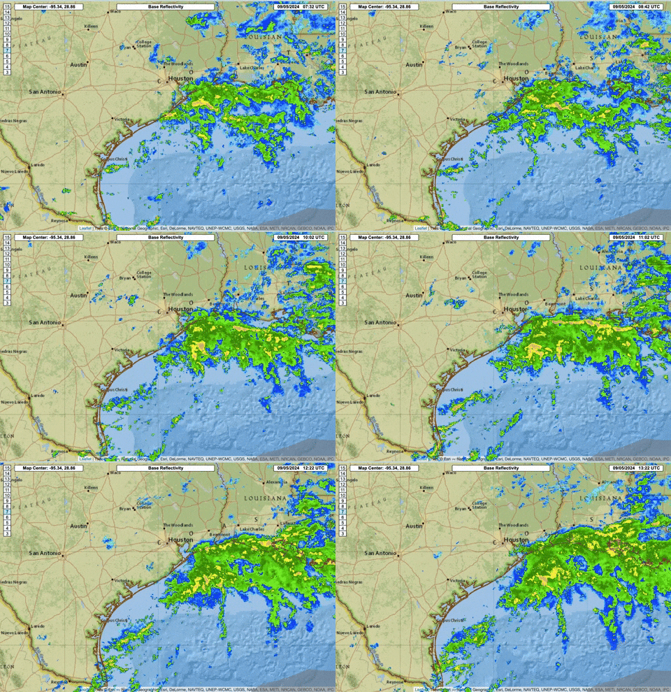
Definitely looking like a quickly coalescing feature on radar but I’m not sure it’s at surface, pressures are dropping so maybe it is, getting very interesting
Last edited by Tailgater33 on Thu Sep 05, 2024 8:50 am, edited 1 time in total.
0 likes   

Stormcenter
S2K Supporter
S2K Supporter
Posts: 6677
Joined: Wed Sep 03, 2003 11:27 am
Location: Houston, TX

Re: Area of disturbed weather in NW Gulf of Mexico (10/10)

#172 Postby Stormcenter » Thu Sep 05, 2024 8:17 am

I would say it’s safe to say something is forming in the
NW Gulf this morning. IMO
0 likes   

texsn95
Tropical Low
Tropical Low
Posts: 25
Joined: Fri Aug 26, 2016 12:34 pm

Re: Area of disturbed weather in NW Gulf of Mexico (10/10)

#173 Postby texsn95 » Thu Sep 05, 2024 8:24 am

Wonderful, I'm in Houma this morning and supposed to fly offshore around noon today... :double:
0 likes   

User avatar
REDHurricane
Category 1
Category 1
Posts: 394
Age: 27
Joined: Sun Jul 03, 2022 2:36 pm
Location: Northeast Pacific Ocean

Re: Area of disturbed weather in NW Gulf of Mexico (10/10)

#174 Postby REDHurricane » Thu Sep 05, 2024 8:29 am

Tailgater33 wrote:Definitely looking like a quickly coalescing feature on radar but I’m not sure it’s at surface pressures are dropping so maybe it is getting very interesting


Image
0 likes   

User avatar
wxman57
Moderator-Pro Met
Moderator-Pro Met
Posts: 22950
Age: 67
Joined: Sat Jun 21, 2003 8:06 pm
Location: Houston, TX (southwest)

Re: Area of disturbed weather in NW Gulf of Mexico (10/10)

#175 Postby wxman57 » Thu Sep 05, 2024 8:37 am

texsn95 wrote:Wonderful, I'm in Houma this morning and supposed to fly offshore around noon today... :double:


What offshore block? Looking fairly rough out there for helicopter flying. I'm seeing 30-35 kt gusts in Green Canyon and Garden Banks.
0 likes   

texsn95
Tropical Low
Tropical Low
Posts: 25
Joined: Fri Aug 26, 2016 12:34 pm

Re: Area of disturbed weather in NW Gulf of Mexico (10/10)

#176 Postby texsn95 » Thu Sep 05, 2024 8:41 am

Horn Mountain, MC127, reel lay vessel, I need to be there before they hang the riser :froze:
0 likes   

User avatar
wxman57
Moderator-Pro Met
Moderator-Pro Met
Posts: 22950
Age: 67
Joined: Sat Jun 21, 2003 8:06 pm
Location: Houston, TX (southwest)

Re: Area of disturbed weather in NW Gulf of Mexico (10/10)

#177 Postby wxman57 » Thu Sep 05, 2024 8:50 am

texsn95 wrote:Horn Mountain, MC127, reel lay vessel, I need to be there before they hang the riser :froze:


Winds and squalls not that bad in Mississippi Canyon, but weather will deteriorate tomorrow afternoon/evening. Platforms in Eugene Island and Garden Banks reporting gusts 35-40 kts.

I started as a marine forecaster for the Gulf in May of 1980. By December, I was sent off to a jack-up platform off the southern tip of Argentina for 28 day rotations.
1 likes   

Frank P
S2K Supporter
S2K Supporter
Posts: 2772
Joined: Fri Aug 29, 2003 10:52 am
Location: Biloxi Beach, Ms
Contact:

Re: Area of disturbed weather in NW Gulf of Mexico (10/10)

#178 Postby Frank P » Thu Sep 05, 2024 8:51 am

Early morning vis and IR loops of the system... been thinking a low pressure would form for the past couple of days, then gave up yesterday noon, then 12 hours later, boom. that's tropics for ya
Image
Image
1 likes   

User avatar
GCANE
S2K Supporter
S2K Supporter
Posts: 11453
Joined: Mon Oct 22, 2007 8:03 am

Re: Area of disturbed weather in NW Gulf of Mexico (10/10)

#179 Postby GCANE » Thu Sep 05, 2024 8:52 am

Looks to be on the edge of an Anti-cyclonic Rossby Wave Break (ARWB).
The ARWB is forecast to strengthen into the Mid GOM.
If the LL Vort of this feature phases with the ARWB, could see some significant development.
0 likes   

User avatar
wxman57
Moderator-Pro Met
Moderator-Pro Met
Posts: 22950
Age: 67
Joined: Sat Jun 21, 2003 8:06 pm
Location: Houston, TX (southwest)

Re: Area of disturbed weather in NW Gulf of Mexico (10/10)

#180 Postby wxman57 » Thu Sep 05, 2024 8:53 am

Looks like a circulation with 20-25 kt winds. Offshore platforms reporting southerly wind gusts 35-40 kts to the east off the middle Louisiana coast. I've seen the NHC call much worse looking systems tropical storms. It does look like the upper trof digs into the Gulf tomorrow, imparting increasing wind shear. HRRR has a 35-40 kt TS by this time tomorrow, though.
1 likes   


Return to “Talkin' Tropics”

Who is online

Users browsing this forum: Google Adsense [Bot], Killjoy12 and 88 guests