ATL: INVEST 90L - Models
Moderator: S2k Moderators
ATL: INVEST 90L - Discussion
This per ICON and others will likely be a (slowly?) strengthening low in the W GOM while starting a S drift ~tomorrow. The models suggest it will be around at least through the late weekend, when it may get further energized by the WNW moving Caribbean AEW.
1 likes
Personal Forecast Disclaimer:
The posts in this forum are NOT official forecasts and should not be used as such. They are just the opinion of the poster and may or may not be backed by sound meteorological data. They are NOT endorsed by any professional institution or storm2k.org. For official information, please refer to the NHC and NWS products.
The posts in this forum are NOT official forecasts and should not be used as such. They are just the opinion of the poster and may or may not be backed by sound meteorological data. They are NOT endorsed by any professional institution or storm2k.org. For official information, please refer to the NHC and NWS products.
-
Stratton23
- Category 5

- Posts: 3517
- Joined: Fri Jul 21, 2023 10:59 pm
- Location: Katy, Tx
Re: ATL: INVEST 90L - Discussion
18z ICON rides up the lower texas coast at a very slow speed, my concern is not for a strong system, but for a weak TS that could potentially stall out, steering is incredibly weak on this run and the jet stream is too far north to really pick it up
1 likes
-
Stratton23
- Category 5
- Posts: 3517
- Joined: Fri Jul 21, 2023 10:59 pm
- Location: Katy, Tx
-
hurricane2025
- Category 1

- Posts: 254
- Joined: Thu Apr 08, 2021 10:36 am
Re: ATL: INVEST 90L - Discussion
Hurricane models will be slow to catch on will take 2-3 days
0 likes

Re: ATL: INVEST 90L - Discussion
(Not a serious post)

1 likes
TC naming lists: retirements and intensity
Most aggressive Advisory #1's in North Atlantic (cr. kevin for starting the list)
Most aggressive Advisory #1's in North Atlantic (cr. kevin for starting the list)

Re: ATL: INVEST 90L - Discussion
hurricane2025 wrote:Hurricane models will be slow to catch on will take 2-3 days
Yeah but it’s just going to be convoluted but still percolating the next few days anyway if the earlier models that saw the pattern were right. I hate the mesoscales from middle SE Texas coast and south. We’ll see what they show but they don’t go out long enough for whatever happens in the BoC. Gonna have to wait for the ICON and later models for the next clues. Still thinking if it doesn’t get super strong if it organizes. Maybe a SC LA eventual landfall around 990’s would be my guess. But still lots of rain and tropical flooding tomorrow for portions of the north Gulf.
0 likes
Re: ATL: INVEST 90L - Discussion
Yo Te. Not only did we make a page a day we made the active threads. Haha. Cheers.
0 likes
-
cycloneye

- Admin

- Posts: 149261
- Age: 69
- Joined: Thu Oct 10, 2002 10:54 am
- Location: San Juan, Puerto Rico
Re: ATL: INVEST 90L - Models
Splited some posts that were related to models at the 90L main thread to create the 90L models thread.
3 likes
Visit the Caribbean-Central America Weather Thread where you can find at first post web cams,radars
and observations from Caribbean basin members Click Here
and observations from Caribbean basin members Click Here
-
Stratton23
- Category 5
- Posts: 3517
- Joined: Fri Jul 21, 2023 10:59 pm
- Location: Katy, Tx
Re: ATL: INVEST 90L - Models
00z ICON rides up the texas coast as a cat 1 hurricane before eventually making landfall right at the Tex/Lousiana border
0 likes
-
hurricane2025
- Category 1
- Posts: 254
- Joined: Thu Apr 08, 2021 10:36 am

Re: ATL: INVEST 90L - Models
Stratton23 wrote:00z ICON rides up the texas coast as a cat 1 hurricane before eventually making landfall right at the Tex/Lousiana border
If that ICON run verifies we will be dealing with 90L for another week. Landfall wouldn’t be til late Wednesday. Could be a long week
0 likes

Re: ATL: INVEST 90L - Models
Stratton23 wrote:00z ICON rides up the texas coast as a cat 1 hurricane before eventually making landfall right at the Tex/Lousiana border
Louisiana gonna get a catastrophic flood if that happens.
0 likes
-
lsuhurricane
- Category 1
- Posts: 270
- Joined: Tue Aug 15, 2017 2:53 pm
Re: ATL: INVEST 90L - Models
And here comes the 0z GFS with a very late emulation of many many ICON runs…..how does this seem to be the pattern of this year so far?
1 likes
Re: ATL: INVEST 90L - Models
lsuhurricane wrote:And here comes the 0z GFS with a very late emulation of many many ICON runs…..how does this seem to be the pattern of this year so far?
And the 0z CMC has a similar solution with bulk of the moisture riding back up the Texas coast into Louisiana
0 likes
-
Stratton23
- Category 5
- Posts: 3517
- Joined: Fri Jul 21, 2023 10:59 pm
- Location: Katy, Tx
Re: ATL: INVEST 90L - Models
GFS next wednesday has a weak TD just offshore off brownsville, by friday it has only moved up to the west of houston and stalls out though its getting sheared, still thats a very slow movement in 4 days, rainfall is going to be something to watch big time in the models
0 likes
Re: ATL: INVEST 90L - Models
Stratton23 wrote:GFS next wednesday has a weak TD just offshore off brownsville, by friday it has only moved up to the west of houston and stalls out though its getting sheared, still thats a very slow movement in 4 days, rainfall is going to be something to watch big time in the models
West of I-45 it could be crickets. Looks to be a sharp cutoff. Long time to go though.
0 likes
Re: ATL: INVEST 90L - Models
0z GEFS has pretty good support for a western Gulf system, with roughly equal chance from the two disturbances.
I don't know if I should put this in the 90L thread or the Caribbean wave thread. Technically, on this run, slightly more members have a TS emerging from Yucatan (i.e. the Caribbean wave likely being dominant) rather than from offshore Texas. But I expect this thread to be more likely to last, so I'm putting it here.
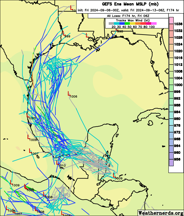
I don't know if I should put this in the 90L thread or the Caribbean wave thread. Technically, on this run, slightly more members have a TS emerging from Yucatan (i.e. the Caribbean wave likely being dominant) rather than from offshore Texas. But I expect this thread to be more likely to last, so I'm putting it here.
2 likes
TC naming lists: retirements and intensity
Most aggressive Advisory #1's in North Atlantic (cr. kevin for starting the list)
Most aggressive Advisory #1's in North Atlantic (cr. kevin for starting the list)

Re: ATL: INVEST 90L - Models
6z GFS now explicitly shows a strong TS forming from a merger between this system and the wave now over the Yucatan. I don’t really expect the solution to stick, but if it does occur, what a win for the ICON.
0 likes
Kendall -> SLO -> PBC
Memorable Storms: Katrina (for its Florida landfall...) Wilma Matthew Irma
Memorable Storms: Katrina (for its Florida landfall...) Wilma Matthew Irma
-
Frank P
- S2K Supporter

- Posts: 2779
- Joined: Fri Aug 29, 2003 10:52 am
- Location: Biloxi Beach, Ms
- Contact:
Re: ATL: INVEST 90L - Models
The ICON showed the dip back south I think on Sept 1 with its 00z run and basically has stuck with that solution... That's pretty impressive in my book. Now I didn't check every single run since Sept 1 but if my memory doesn't fail me, I do believe most of its runs were similar. And if it verifies again and comes to fruition, and it is gaining support from the big boys now, you have to admit it's been quite effective in the NW GOM.
2 likes
-
hurricane2025
- Category 1
- Posts: 254
- Joined: Thu Apr 08, 2021 10:36 am
Who is online
Users browsing this forum: No registered users and 32 guests