NAM 3k

GFS

ECMWF

Moderator: S2k Moderators


TomballEd wrote:I think the 3km NAM had a sub 700 mb storm in the Gulf. The 3km hurricane models are calibrated to somewhat accurately predict strength, but the 3km NAM is a smidge enthusiastic developing systems.

Hammy wrote:TomballEd wrote:I think the 3km NAM had a sub 700 mb storm in the Gulf. The 3km hurricane models are calibrated to somewhat accurately predict strength, but the 3km NAM is a smidge enthusiastic developing systems.
Never seen that on the NAM, I think that was the HWRF or related model at one point.
It's gone sub-900 several times on hurricanes that ended up low-end Cat 2 in the end
Kazmit wrote:GFS has liked the idea of a westward tracking MDR major for 3 of the past 4 runs. The 18z one looks very Irma-esque. Still a ways out since the wave that forms it doesn’t exit Africa until Monday. Even if it doesn’t verify the fact that it’s been showing anything at all is perhaps a hint of the switch flip happening as we enter mid-September.


Teban54 wrote:Kazmit wrote:GFS has liked the idea of a westward tracking MDR major for 3 of the past 4 runs. The 18z one looks very Irma-esque. Still a ways out since the wave that forms it doesn’t exit Africa until Monday. Even if it doesn’t verify the fact that it’s been showing anything at all is perhaps a hint of the switch flip happening as we enter mid-September.
Maria may be a better track analog, as it does clip NE Caribbean and then Puerto Rico, and it also moves due north starting from around Bahamas.
Regardless, track at this lead time is almost meaningless, but GFS has shown a long-tracking CV hurricane for 6 out of its 9 most recent runs now, including 4 out of the 5 most recent ones. Euro has also shown development of the same wave for all but one of its recent full-length runs ever since this wave entered the 10-day time frame, albeit at varying intensities. CMC also jumped on board for the first time in its 12z run today.

Kazmit wrote:GFS has liked the idea of a westward tracking MDR major for 3 of the past 4 runs. The 18z one looks very Irma-esque. Still a ways out since the wave that forms it doesn’t exit Africa until Monday. Even if it doesn’t verify the fact that it’s been showing anything at all is perhaps a hint of the switch flip happening as we enter mid-September.
Kazmit wrote:GFS has liked the idea of a westward tracking MDR major for 3 of the past 4 runs. The 18z one looks very Irma-esque. Still a ways out since the wave that forms it doesn’t exit Africa until Monday. Even if it doesn’t verify the fact that it’s been showing anything at all is perhaps a hint of the switch flip happening as we enter mid-September.
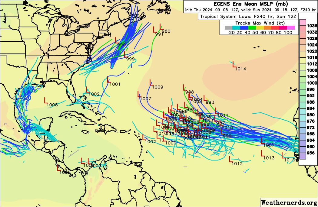
Teban54 wrote:In addition to the operational models (including Euro itself), 12z EPS is also quite active, a tad more so than 0z:
https://i.postimg.cc/D0WztnXj/ecens-2024-09-05-12-Z-240-50-258-0-350-MSLP-Surface-tracks-lows.png
Teban54 wrote:In addition to the operational models (including Euro itself), 12z EPS is also quite active, a tad more so than 0z:
https://i.postimg.cc/D0WztnXj/ecens-2024-09-05-12-Z-240-50-258-0-350-MSLP-Surface-tracks-lows.png
MarioProtVI wrote:Teban54 wrote:In addition to the operational models (including Euro itself), 12z EPS is also quite active, a tad more so than 0z:
https://i.postimg.cc/D0WztnXj/ecens-2024-09-05-12-Z-240-50-258-0-350-MSLP-Surface-tracks-lows.png
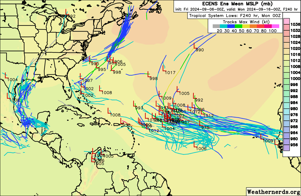
And now the Euro doesn’t even develop it anymore on 00z. Given its past history of detecting supposedly favorable conditions and adjusting (and ending up right quite often), I have to wonder if this is yet another false flag by the models that may easily end up falling flat on its face.

Users browsing this forum: No registered users and 123 guests


