Northwestern Caribbean Sea and Southwestern Gulf of Mexico:
A tropical wave located over the western Caribbean Sea is producing
a large area of disorganized shower and thunderstorm activity.
Development is not expected before the system reaches Belize and the
Yucatan Peninsula by early Friday. Some slow development is possible
later this weekend after the system emerges over the southwestern
Gulf of Mexico.
* Formation chance through 48 hours...low...near 0 percent.
* Formation chance through 7 days...low...20 percent.
Tropical Wave in Bay of Campeche (Is Invest 91L)
Moderator: S2k Moderators
Forum rules

The posts in this forum are NOT official forecasts and should not be used as such. They are just the opinion of the poster and may or may not be backed by sound meteorological data. They are NOT endorsed by any professional institution or STORM2K. For official information, please refer to products from the National Hurricane Center and National Weather Service.
-
cycloneye

- Admin

- Posts: 149261
- Age: 69
- Joined: Thu Oct 10, 2002 10:54 am
- Location: San Juan, Puerto Rico
Re: Tropical Wave in Western Caribbean (0/20)
0 likes
Visit the Caribbean-Central America Weather Thread where you can find at first post web cams,radars
and observations from Caribbean basin members Click Here
and observations from Caribbean basin members Click Here
-
MEANINGLESS_NUMBERS
- Category 2

- Posts: 503
- Joined: Mon Nov 02, 2020 1:43 pm
Re: Tropical Wave in Western Caribbean (0/20)
Looking at the models I’d say 20% is generous. On track to be the biggest fizzle of the year so far.
0 likes
Emily '87, Felix '95, Gert '99, Fabian '03, Humberto '19, Paulette '20, Teddy '20, Fiona '22, Lee '23, Ernesto '24, Humberto/Imelda '25

Re: Tropical Wave in Western Caribbean (0/20)
I posted 0z GEFS in the 90L thread, but the important thing is that support for TS winds coming from Yucatan (i.e. most likely this Caribbean system) has increased slightly compared to the 12z run, and significantly compared to the 18z run.
1 likes
TC naming lists: retirements and intensity
Most aggressive Advisory #1's in North Atlantic (cr. kevin for starting the list)
Most aggressive Advisory #1's in North Atlantic (cr. kevin for starting the list)
-
cycloneye
- Admin
- Posts: 149261
- Age: 69
- Joined: Thu Oct 10, 2002 10:54 am
- Location: San Juan, Puerto Rico
Re: Tropical Wave in SW GOM (20/40)
Up to 20%/40% at 2 PM.
Southwestern Gulf of Mexico:
A tropical wave located over Belize and the Yucatan Peninsula of
Mexico is producing disorganized showers and thunderstorms. The
wave is forecast to move into the Bay of Campeche on Saturday,
where it could then begin to interact with a frontal boundary. A
tropical depression could form during the early or middle part of
next week while the system moves slowly northwestward over the
southwestern Gulf of Mexico.
* Formation chance through 48 hours...low...20 percent.
* Formation chance through 7 days...medium...40 percent.
1 likes
Visit the Caribbean-Central America Weather Thread where you can find at first post web cams,radars
and observations from Caribbean basin members Click Here
and observations from Caribbean basin members Click Here
-
hurricane2025
- Category 1

- Posts: 254
- Joined: Thu Apr 08, 2021 10:36 am
Re: Tropical Wave in SW GOM (20/40)
Perhaps this 52-page thread won't be a waste after all.
3 likes
TC naming lists: retirements and intensity
Most aggressive Advisory #1's in North Atlantic (cr. kevin for starting the list)
Most aggressive Advisory #1's in North Atlantic (cr. kevin for starting the list)
-
TomballEd
- Category 5

- Posts: 1260
- Age: 62
- Joined: Wed Aug 16, 2023 4:52 pm
- Location: Spring/Klein area, not Tomball
Re: Tropical Wave in SW GOM (20/40)
I see a thread title for the Atlantic invest 2 posts above (99L)
Many ensembles seem to develop this, almost all are weak, but pressures suggests some TS. It is like I'm back on page 3, when I was excited by the Euro/ECENS support.
Delayed, likely not a 'big name' storm, but maybe an NS.
Many ensembles seem to develop this, almost all are weak, but pressures suggests some TS. It is like I'm back on page 3, when I was excited by the Euro/ECENS support.
Delayed, likely not a 'big name' storm, but maybe an NS.
1 likes
-
TomballEd
- Category 5
- Posts: 1260
- Age: 62
- Joined: Wed Aug 16, 2023 4:52 pm
- Location: Spring/Klein area, not Tomball
Re: Tropical Wave in SW GOM (20/40)
Alison, not Harvey, would be a better reference. Harvey only got water halfway up my front lawn and driveway, Alison had water in my garage and water stains on the very bottom of my front door. Towels actually worked and kept water out of my house. My wife was pregnant with our first, it was scary, and then her cousins and grandparents (primos y abuelos) had soaked carpets and soaked drywall. Pain in the rear tearing up wet carpet padding,
SW Gulf AOI forecast by GFS (and other models) to drop a lot of rain in the next. COD model site GFS shows a 17 inch bullseye a bit N of CRP.

SW Gulf AOI forecast by GFS (and other models) to drop a lot of rain in the next. COD model site GFS shows a 17 inch bullseye a bit N of CRP.
0 likes
-
Hurricane2022

- Category 5
- Posts: 2016
- Joined: Tue Aug 23, 2022 11:38 pm
- Location: Araçatuba, Brazil
Re: Disturbed weather in Central Atlantic (0/20)
wxman57 wrote:Nah, no issue for my days off. Models are backing off on any development overnight. Best chance of development may be off the East U.S. Coast in a week or so along a front.
10 days ago...

2 likes
Sorry for the bad English sometimes...!
For reliable and detailed information for any meteorological phenomenon, please consult the National Hurricane Center, Joint Typhoon Warning Center , or your local Meteo Center.
--------
ECCE OMNIA NOVA FACIAM (Ap 21,5).
For reliable and detailed information for any meteorological phenomenon, please consult the National Hurricane Center, Joint Typhoon Warning Center , or your local Meteo Center.
--------
ECCE OMNIA NOVA FACIAM (Ap 21,5).

Re: Tropical Wave in SW GOM (20/40)
The 12z UKMet again develops this, hard to believe we have been watching this wave for so long.

0 likes
Kendall -> SLO -> PBC
Memorable Storms: Katrina (for its Florida landfall...) Wilma Matthew Irma
Memorable Storms: Katrina (for its Florida landfall...) Wilma Matthew Irma


-
cajungal
- Category 5
- Posts: 2354
- Age: 49
- Joined: Sun Mar 14, 2004 9:34 pm
- Location: Schriever, Louisiana (60 miles southwest of New Orleans)
Re: Tropical Wave in SW GOM (20/40)
Season almost completely shut down after Ernesto and yet something still has to find its way to Louisiana
3 likes
Re: Tropical Wave in SW GOM (20/40)
Looks like 90L won’t be designated, but the two systems might interact to produce this system here.
Definitely looking more and more likely that this thread won’t be wasted, but this is certainly going into the Storm2K history books as one of the longest (if not the longest) threads for a system before it is invested haha
Definitely looking more and more likely that this thread won’t be wasted, but this is certainly going into the Storm2K history books as one of the longest (if not the longest) threads for a system before it is invested haha
0 likes
-
Stormlover70
- Tropical Storm

- Posts: 194
- Age: 56
- Joined: Fri Jun 21, 2024 5:31 am
- Location: New port richey
Re: Tropical Wave in SW GOM (20/40)
The early bullseye is best.cajungal wrote:Season almost completely shut down after Ernesto and yet something still has to find its way to Louisiana
0 likes
Re: Tropical Wave in SW GOM (20/40)
TomballEd wrote:I see a thread title for the Atlantic invest 2 posts above (99L)
Also, the NHC definitely lost a golden opportunity not designating this as 99L back when it was first a traceable system. Would have definitely fit perfectly alongside all the other infamous 99Ls in recent years that took forever to develop
4 likes
-
Frank P
- S2K Supporter

- Posts: 2779
- Joined: Fri Aug 29, 2003 10:52 am
- Location: Biloxi Beach, Ms
- Contact:
Re: Tropical Wave in SW GOM (20/40)
The tropical wave over the Yucatan and NW Caribbean is about as weak as they come. Much more impressive blob of convection and lightning in Nicaragua and Honduras and their coastal waters. Blob appears to be moving NW.

0 likes
Re: Tropical Wave in SW GOM (20/40)
Frank P wrote:The tropical wave over the Yucatan and NW Caribbean is about as weak as they come. Much more impressive blob of convection and lightning in Nicaragua and Honduras and their coastal waters. Blob appears to be moving NW.
https://i.ibb.co/H7vb50d/69803805.gif
The vorticity over Central America is the strongest I remember ever seeing from this wave:
1 likes
TC naming lists: retirements and intensity
Most aggressive Advisory #1's in North Atlantic (cr. kevin for starting the list)
Most aggressive Advisory #1's in North Atlantic (cr. kevin for starting the list)
-
Frank P
- S2K Supporter
- Posts: 2779
- Joined: Fri Aug 29, 2003 10:52 am
- Location: Biloxi Beach, Ms
- Contact:
Re: Tropical Wave in SW GOM (20/40)
Teban54 wrote:Frank P wrote:The tropical wave over the Yucatan and NW Caribbean is about as weak as they come. Much more impressive blob of convection and lightning in Nicaragua and Honduras and their coastal waters. Blob appears to be moving NW.
https://i.ibb.co/H7vb50d/69803805.gif
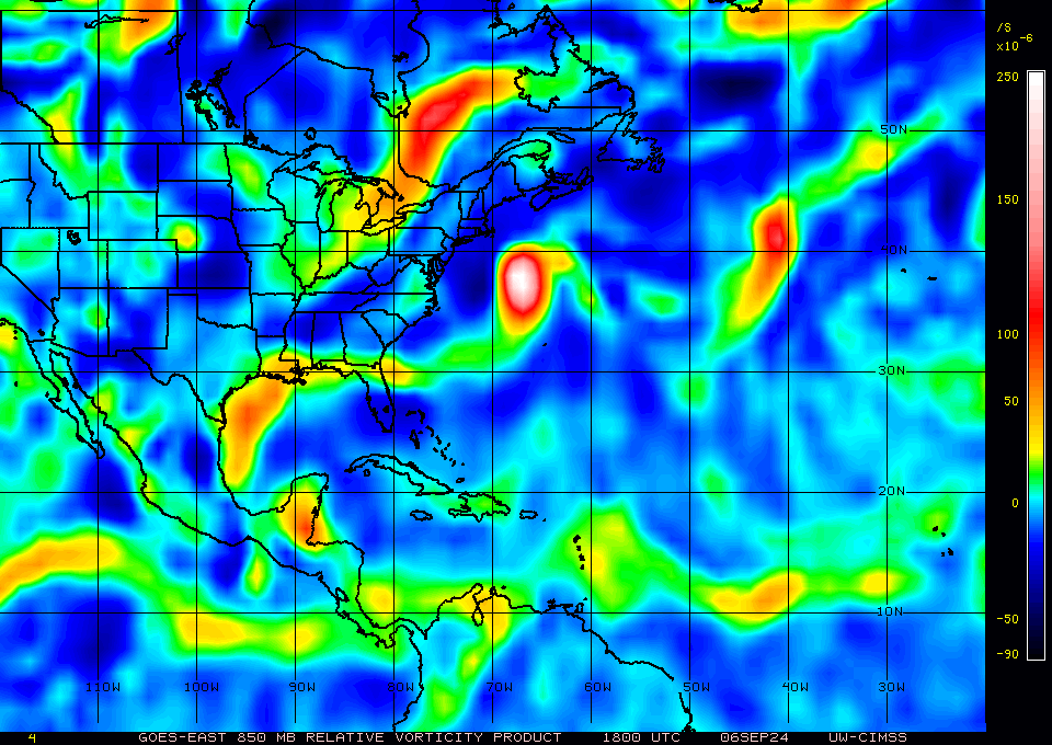
The vorticity over Central America is the strongest I remember ever seeing from this wave:
https://i.postimg.cc/Bbtc4mB5/image.png
Vorticity without convection=nothing... that's not to say it won't happen and maybe tonight convection will pick up... seems like that the MOI of this dang wave we've been tracking for it seems like weeks favors night time convection... side note: the vorcity over the NW GOM is also impressive... and it has 0% chance of development... Obviously the PHDs at the NHC see a lot more data than just a sat loop, so I'll trust their judgement. But as waves go, this is pitiful... will watch tonight for any flare ups.. Cheers Te
0 likes
-
Edwards Limestone

- S2K Supporter
- Posts: 504
- Age: 36
- Joined: Tue Dec 28, 2021 11:05 am
- Location: Smithson Valley, TX
Re: Disturbed weather in Central Atlantic (0/20)
.
0 likes
The above post is NOT an official forecast and should not be used as such. It is just the opinion of the poster and may or may not be backed by sound meteorological data. It is NOT endorsed by any professional institution including Storm2k. For official information, please refer to NWS products.
Who is online
Users browsing this forum: mixedDanilo.E and 88 guests