Area of low pressure in Central Atlantic (Is Invest 92L)

This is the general tropical discussion area. Anyone can take their shot at predicting a storms path.

Moderator: S2k Moderators

Forum rules

The posts in this forum are NOT official forecasts and should not be used as such. They are just the opinion of the poster and may or may not be backed by sound meteorological data. They are NOT endorsed by any professional institution or STORM2K. For official information, please refer to products from the National Hurricane Center and National Weather Service.

Help Support Storm2K
Message
Author
User avatar
Teban54
Category 5
Category 5
Posts: 3168
Joined: Sat May 19, 2018 1:19 pm

Re: Tropical Wave in Eastern Atlantic (0/10)

#21 Postby Teban54 » Thu Sep 05, 2024 8:19 pm

cycloneye wrote:Northwestern Caribbean Sea and Southwestern Gulf of Mexico:
A tropical wave located over the western Caribbean Sea is producing
a large area of disorganized shower and thunderstorm activity.
Development is not expected before the system reaches Belize and the
Yucatan Peninsula by early Friday. Some slow development is possible
later this weekend after the system emerges over the southwestern
Gulf of Mexico.
* Formation chance through 48 hours...low...near 0 percent.
* Formation chance through 7 days...low...20 percent.

I think you pasted the wrong system? It says NW Caribbean in your comment.

Anyway, with the downgrade to 0/10, NHC also removed the X marker from the map, possibly because the disturbance no longer has a well-defined center. This tricked me for a second, as I thought they had added the modeled MDR storm next week to the TWO (they didn't).
0 likes   

User avatar
cycloneye
Admin
Admin
Posts: 143863
Age: 68
Joined: Thu Oct 10, 2002 10:54 am
Location: San Juan, Puerto Rico

Re: Tropical Wave in Eastern Atlantic (0/10)

#22 Postby cycloneye » Thu Sep 05, 2024 9:19 pm

Oh boy. Here is the right one Teban54.

Eastern Tropical Atlantic:
An elongated trough of low pressure over the eastern tropical
Atlantic is producing limited shower and thunderstorm activity.
Development, if any, should be slow to occur during the early part
of next week while the disturbance moves slowly northwestward or
northward over the eastern tropical Atlantic.
* Formation chance through 48 hours...low...near 0 percent.
* Formation chance through 7 days...low...10 percent.
0 likes   
Visit the Caribbean-Central America Weather Thread where you can find at first post web cams,radars
and observations from Caribbean basin members Click Here

User avatar
cycloneye
Admin
Admin
Posts: 143863
Age: 68
Joined: Thu Oct 10, 2002 10:54 am
Location: San Juan, Puerto Rico

Re: Trough in Eastern Atlantic (0/20)

#23 Postby cycloneye » Fri Sep 06, 2024 6:25 pm

Eastern and Central Tropical Atlantic:
An elongated trough of low pressure over the eastern and central
tropical Atlantic is producing broad shower and thunderstorm
activity. A more concentrated area of low pressure may form within
this region during the next couple of days. Any development of this
system should be slow to occur while the disturbance meanders
through the early part of next week and then begins to move
west-northwestward across the central tropical Atlantic during the
middle to latter part of next week.
* Formation chance through 48 hours...low...near 0 percent.
* Formation chance through 7 days...low...20 percent.
0 likes   
Visit the Caribbean-Central America Weather Thread where you can find at first post web cams,radars
and observations from Caribbean basin members Click Here

MEANINGLESS_NUMBERS
Category 1
Category 1
Posts: 325
Joined: Mon Nov 02, 2020 1:43 pm

Re: Trough in Eastern Atlantic (0/20)

#24 Postby MEANINGLESS_NUMBERS » Fri Sep 06, 2024 8:25 pm

This is the one that the GFS puts near Bermuda on day 10?
0 likes   
Emily '87, Felix '95, Gert '99, Fabian '03, Humberto '19, Paulette '20, Teddy '20, Fiona '22, Lee '23, Ernesto '24

User avatar
Hurricaneman
Category 5
Category 5
Posts: 7349
Age: 44
Joined: Tue Aug 31, 2004 3:24 pm
Location: central florida

Re: Trough in Eastern Atlantic (0/20)

#25 Postby Hurricaneman » Fri Sep 06, 2024 9:35 pm

MEANINGLESS_NUMBERS wrote:This is the one that the GFS puts near Bermuda on day 10?

I believe so
0 likes   

User avatar
Teban54
Category 5
Category 5
Posts: 3168
Joined: Sat May 19, 2018 1:19 pm

Re: Trough in Eastern Atlantic (0/20)

#26 Postby Teban54 » Fri Sep 06, 2024 9:50 pm

MEANINGLESS_NUMBERS wrote:This is the one that the GFS puts near Bermuda on day 10?

Yes, but the only GFS runs that developed this into anything more than a weak TD/TS are: 18z 9/6, 6z 9/6, 6z 9/4 and 18z 9/3. All other developing runs between 9/4 and 9/6 don't do much with this, and instead have the following wave that emerges from Africa on 9/10 as the dominant system.
0 likes   

User avatar
cycloneye
Admin
Admin
Posts: 143863
Age: 68
Joined: Thu Oct 10, 2002 10:54 am
Location: San Juan, Puerto Rico

Re: Trough in Eastern - Central Atlantic (0/30)

#27 Postby cycloneye » Sat Sep 07, 2024 7:00 am

Eastern and Central Tropical Atlantic:
An elongated trough of low pressure over the eastern and central
tropical Atlantic is producing a broad area of shower and
thunderstorm activity. A more well-defined area of low pressure may
form within this region during the next few days. Some slow
development of this system is possible while the disturbance
meanders through the early part of next week, then begins to move
west-northwestward across the central tropical Atlantic during the
middle to latter part of next week.
* Formation chance through 48 hours...low...near 0 percent.
* Formation chance through 7 days...low...30 percent.
0 likes   
Visit the Caribbean-Central America Weather Thread where you can find at first post web cams,radars
and observations from Caribbean basin members Click Here

User avatar
Teban54
Category 5
Category 5
Posts: 3168
Joined: Sat May 19, 2018 1:19 pm

Re: Trough in East-Central Atlantic (0/30)

#28 Postby Teban54 » Sat Sep 07, 2024 9:22 am

GFS has made this a recurving hurricane on several of the recent runs (6z 9/7, 18z 9/7, 6z 9/8), sometimes in place of the following 9/10 wave.
0 likes   

User avatar
DorkyMcDorkface
Category 3
Category 3
Posts: 816
Age: 27
Joined: Mon Sep 30, 2019 1:32 pm
Location: Mid-Atlantic

Re: Trough in East-Central Atlantic (0/30)

#29 Postby DorkyMcDorkface » Sat Sep 07, 2024 10:07 am

Image
1 likes   
Please note the thougths expressed by this account are solely those of the user and are from a hobbyist perspective. For more comprehensive analysis, consult an actual professional meteorologist or meteorology agency.


Floyd 1999 | Isabel 2003 | Hanna 2008 | Irene 2011 | Sandy 2012 | Isaias 2020

MEANINGLESS_NUMBERS
Category 1
Category 1
Posts: 325
Joined: Mon Nov 02, 2020 1:43 pm

Re: Trough in East-Central Atlantic (0/30)

#30 Postby MEANINGLESS_NUMBERS » Sat Sep 07, 2024 10:11 am

0 likes   
Emily '87, Felix '95, Gert '99, Fabian '03, Humberto '19, Paulette '20, Teddy '20, Fiona '22, Lee '23, Ernesto '24

User avatar
cycloneye
Admin
Admin
Posts: 143863
Age: 68
Joined: Thu Oct 10, 2002 10:54 am
Location: San Juan, Puerto Rico

Re: Trough in East-Central Atlantic (0/30)

#31 Postby cycloneye » Sat Sep 07, 2024 12:56 pm

Central Tropical Atlantic:
An area of low pressure over the central tropical Atlantic is
producing disorganized showers and thunderstorms. Gradual
development of this system is possible while the system meanders
during the next couple of days, and a tropical depression could form
early next week. The system is then forecast to move
west-northwestward at about 10 mph across the central tropical
Atlantic during the middle to latter part of next week.
* Formation chance through 48 hours...low...10 percent.
* Formation chance through 7 days...medium...40 percent.
1 likes   
Visit the Caribbean-Central America Weather Thread where you can find at first post web cams,radars
and observations from Caribbean basin members Click Here

User avatar
Teban54
Category 5
Category 5
Posts: 3168
Joined: Sat May 19, 2018 1:19 pm

Re: Tropical Wave in Eastern Atlantic (0/30)

#32 Postby Teban54 » Sat Sep 07, 2024 1:01 pm

Teban54 wrote:Up to 10/40. [From 5 days ago, on Monday, September 2]
3. Eastern Tropical Atlantic Ocean:
A tropical wave along the west coast of Africa is producing a large
area of showers and thunderstorms. Environmental conditions are
forecast to gradually become more favorable for development, and a
tropical depression could form in a few days while the disturbance
moves slowly west-northwestward or northwestward over the eastern
tropical Atlantic Ocean.
* Formation chance through 48 hours...low...10 percent.
* Formation chance through 7 days...medium...40 percent.


Never thought I'd use this meme for anything other than EPAC this season, but here we are.
https://i.postimg.cc/ryWXZJHm/image.png

Coincidentally, both of the only two orange AOIs since Ernesto went through a cycle of "orange > lemon > back to orange". (The other is now 91L.)

So I'm gonna try reviving the meme a bit:

Image
5 likes   

Pelicane
Tropical Storm
Tropical Storm
Posts: 100
Joined: Tue Sep 13, 2022 1:52 pm
Location: Lafayette, Louisiana

Re: Trough in Central Atlantic (10/40)

#33 Postby Pelicane » Sat Sep 07, 2024 5:20 pm

GFS likes this feature again. Strong H just north of the islands.
0 likes   

User avatar
cycloneye
Admin
Admin
Posts: 143863
Age: 68
Joined: Thu Oct 10, 2002 10:54 am
Location: San Juan, Puerto Rico

Re: Trough in Central Atlantic (10/40)

#34 Postby cycloneye » Sat Sep 07, 2024 5:23 pm

Teban54, this time, GFS develops this one.

Image
4 likes   
Visit the Caribbean-Central America Weather Thread where you can find at first post web cams,radars
and observations from Caribbean basin members Click Here

Cachondo23
Tropical Depression
Tropical Depression
Posts: 73
Joined: Wed May 25, 2022 5:56 am

Re: Trough in Central Atlantic (10/40)

#35 Postby Cachondo23 » Sat Sep 07, 2024 5:48 pm

cycloneye wrote:Teban54, this time, GFS develops this one.

https://i.imgur.com/XeFqqPC.gif

Even though long range at the moment, does the GFS have a High Pressure that it keeps moving it west?
0 likes   

User avatar
cycloneye
Admin
Admin
Posts: 143863
Age: 68
Joined: Thu Oct 10, 2002 10:54 am
Location: San Juan, Puerto Rico

Re: Trough in Central Atlantic (30/50)

#36 Postby cycloneye » Sat Sep 07, 2024 6:37 pm

8 PM:

Central Tropical Atlantic:
Shower and thunderstorm activity associated with an area of low
pressure over the central tropical Atlantic has begun to show signs
of organization. Gradual additional development is possible while
the system meanders over the central tropical Atlantic through
Monday and then moves generally westward at about 10 mph through the
rest of next week.
* Formation chance through 48 hours...low...30 percent.
* Formation chance through 7 days...medium...50 percent.
0 likes   
Visit the Caribbean-Central America Weather Thread where you can find at first post web cams,radars
and observations from Caribbean basin members Click Here

User avatar
Teban54
Category 5
Category 5
Posts: 3168
Joined: Sat May 19, 2018 1:19 pm

Re: Area of low pressure in Central Atlantic (30/50)

#37 Postby Teban54 » Sat Sep 07, 2024 6:44 pm

18z GFS has Sandy 2.0.
1 likes   

User avatar
AnnularCane
S2K Supporter
S2K Supporter
Posts: 2836
Joined: Thu Jun 08, 2006 9:18 am
Location: Wytheville, VA

Re: Area of low pressure in Central Atlantic (30/50)

#38 Postby AnnularCane » Sat Sep 07, 2024 7:26 pm

Teban54 wrote:18z GFS has Sandy 2.0.


Except this one changes its mind at the last second and loops back east. :lol:
0 likes   
"But it never rained rain. It never snowed snow. And it never blew just wind. It rained things like soup and juice. It snowed mashed potatoes and green peas. And sometimes the wind blew in storms of hamburgers." -- Judi Barrett, Cloudy with a Chance of Meatballs

User avatar
cycloneye
Admin
Admin
Posts: 143863
Age: 68
Joined: Thu Oct 10, 2002 10:54 am
Location: San Juan, Puerto Rico

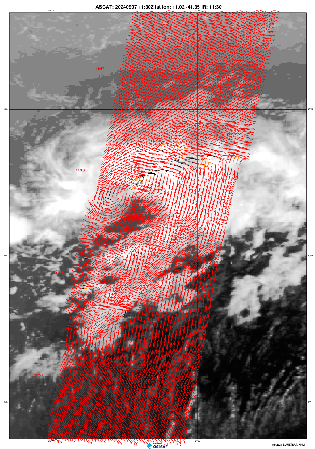
Re: Area of low pressure in Central Atlantic (Is Invest 92L)

#39 Postby cycloneye » Sat Sep 07, 2024 7:53 pm

0 likes   
Visit the Caribbean-Central America Weather Thread where you can find at first post web cams,radars
and observations from Caribbean basin members Click Here


Return to “Talkin' Tropics”

Who is online

Users browsing this forum: No registered users and 79 guests