Low pressure trough in the Central Atlantic/Tropical Wave Near the Cabo Verde Islands (Is Invest 93L)

This is the general tropical discussion area. Anyone can take their shot at predicting a storms path.

Moderator: S2k Moderators

Forum rules

The posts in this forum are NOT official forecasts and should not be used as such. They are just the opinion of the poster and may or may not be backed by sound meteorological data. They are NOT endorsed by any professional institution or STORM2K. For official information, please refer to products from the National Hurricane Center and National Weather Service.

Help Support Storm2K
Message
Author
User avatar
cycloneye
Admin
Admin
Posts: 143862
Age: 68
Joined: Thu Oct 10, 2002 10:54 am
Location: San Juan, Puerto Rico

Low pressure trough in the Central Atlantic/Tropical Wave Near the Cabo Verde Islands (Is Invest 93L)

#1 Postby cycloneye » Sat Sep 07, 2024 1:01 pm

Complicated scenario here with the monsoon trough and wave that will emerge next week.


Eastern and Central Tropical Atlantic:
Disorganized showers and thunderstorms associated with a trough of
low pressure are located several hundred miles east-southeast of
the Cabo Verde Islands. Some slow development of this system is
possible as it interacts with a tropical wave expected to move off
the African continent early next week and moves west-northwestward
at 5 to 10 mph.
* Formation chance through 48 hours...low...near 0 percent.
* Formation chance through 7 days...low...20 percent.
1 likes   
Visit the Caribbean-Central America Weather Thread where you can find at first post web cams,radars
and observations from Caribbean basin members Click Here

User avatar
Teban54
Category 5
Category 5
Posts: 3168
Joined: Sat May 19, 2018 1:19 pm

Re: Trough of low pressure in East-Central Atiantic / Wave that will emerge from West Africa (0/20)

#2 Postby Teban54 » Sat Sep 07, 2024 1:05 pm

This is the wave that GFS was hyping up to be the long-tracking MH from a few days ago. More recent runs often favor the 10/40 AOI (making it the recurving MH instead), and have this wave either badly sheared or not develop at all. However, 12z GFS has a solution where the eastern half of the trough becomes dominant and absorbs the wave.

Euro was showing this wave developing immediately off Africa a while ago, but has since dropped it. (Note that GFS almost never showed it developing that far east.) 12z CMC was trying to spin this up, but it became less organized upon reaching central Atlantic.

Both this wave and the 10/40 still have decent support from both GEFS and EPS.
0 likes   

User avatar
Ubuntwo
Category 5
Category 5
Posts: 1401
Age: 31
Joined: Thu Oct 05, 2017 10:41 pm

Re: Trough of low pressure in East-Central Atiantic / Wave that will emerge from West Africa (0/20)

#3 Postby Ubuntwo » Sat Sep 07, 2024 1:44 pm

12z Euro ends with a strong hurricane northeast of the Leewards. This is from the eastern end of the monsoon trough, the same area the 12z GFS developed.
Image
2 likes   
Kendall -> SLO -> PBC

Memorable Storms: Katrina (for its Florida landfall...) Wilma Matthew Irma

User avatar
cycloneye
Admin
Admin
Posts: 143862
Age: 68
Joined: Thu Oct 10, 2002 10:54 am
Location: San Juan, Puerto Rico

Re: Trough of low pressure in East-Central Atiantic / Wave that will emerge from West Africa (0/20)

#4 Postby cycloneye » Sat Sep 07, 2024 1:52 pm

12z Euro develops this area as the wave emerges from Africa and then merges with the monsoon trough.

Image
0 likes   
Visit the Caribbean-Central America Weather Thread where you can find at first post web cams,radars
and observations from Caribbean basin members Click Here

User avatar
cycloneye
Admin
Admin
Posts: 143862
Age: 68
Joined: Thu Oct 10, 2002 10:54 am
Location: San Juan, Puerto Rico

Re: Trough of low pressure in East-Central Atiantic / Wave that will emerge from West Africa (0/40)

#5 Postby cycloneye » Sat Sep 07, 2024 6:48 pm

8 PM:

Eastern and Central Tropical Atlantic:
Disorganized showers and thunderstorms associated with a trough of
low pressure are located several hundred miles southwest of
the Cabo Verde Islands. The disturbance is expected to move very
little during the next few days until it potentially interacts with
a tropical wave that is forecast to move off the west coast of
Africa by early Monday. Environmental conditions are expected to be
favorable for gradual development of this system, and a tropical
depression could form by the middle or late portions of next week.
The system is expected to begin moving slowly westward by the end
of the week.
* Formation chance through 48 hours...low...near 0 percent.
* Formation chance through 7 days...medium...40 percent.
0 likes   
Visit the Caribbean-Central America Weather Thread where you can find at first post web cams,radars
and observations from Caribbean basin members Click Here

User avatar
Teban54
Category 5
Category 5
Posts: 3168
Joined: Sat May 19, 2018 1:19 pm

Re: Trough of low pressure in East-Central Atiantic / Wave that will emerge from West Africa (0/40)

#6 Postby Teban54 » Sat Sep 07, 2024 7:03 pm

Three concurrent oranges? That can't be 2024, right?
4 likes   

User avatar
Teban54
Category 5
Category 5
Posts: 3168
Joined: Sat May 19, 2018 1:19 pm

Re: Trough of low pressure in East-Central Atiantic / Wave that will emerge from West Africa (0/40)

#7 Postby Teban54 » Sun Sep 08, 2024 12:52 am

Up to 0/50.

3. Eastern and Central Tropical Atlantic:
A trough of low pressure located several hundred miles southwest of
the Cabo Verde Islands is producing some disorganized showers and
thunderstorms. The disturbance is expected to move very little
during the next couple of days until it potentially interacts with
a tropical wave that is forecast to move off the west coast of
Africa by early Monday. Environmental conditions are expected to be
favorable for gradual development of this system, and a tropical
depression could form by the middle or latter part of the week while
the system moves slowly westward.
* Formation chance through 48 hours...low...near 0 percent.
* Formation chance through 7 days...medium...50 percent.
0 likes   

User avatar
Teban54
Category 5
Category 5
Posts: 3168
Joined: Sat May 19, 2018 1:19 pm

Re: Trough of low pressure in East-Central Atiantic / Wave that will emerge from West Africa (0/40)

#8 Postby Teban54 » Sun Sep 08, 2024 2:02 am

0z Euro continues to be aggressive with this system. At the end of this run, it intensifies from 976 mb to 953 mb within 24 hours. Operational Euro is usually very conservative with intensity, so seeing pressure in the 950s is huge.

0z GFS also peaks this at 952 mb, as this run has the system free of interference from 92L.

Regardless of how many systems come out of MDR (I still think 1 is the most likely), one system will have great potential.
1 likes   

User avatar
cycloneye
Admin
Admin
Posts: 143862
Age: 68
Joined: Thu Oct 10, 2002 10:54 am
Location: San Juan, Puerto Rico

Re: Trough of low pressure in East-Central Atiantic / Wave that will emerge from West Africa (0/50)

#9 Postby cycloneye » Sun Sep 08, 2024 6:49 am

8 AM:

Eastern and Central Tropical Atlantic:
A trough of low pressure located several hundred miles southwest of
the Cabo Verde Islands is producing a broad area of disorganized
showers and thunderstorms. This system is expected to move very
little during the next couple of days until it potentially interacts
with a tropical wave that is forecast to move off the west coast of
Africa on Monday. Environmental conditions thereafter are expected
to be favorable for gradual development of this system, and a
tropical depression could form by the middle or latter part of the
week while the system begins moving slowly west-northwestward.
* Formation chance through 48 hours...low...near 0 percent.
* Formation chance through 7 days...medium...50 percent.
0 likes   
Visit the Caribbean-Central America Weather Thread where you can find at first post web cams,radars
and observations from Caribbean basin members Click Here

User avatar
gatorcane
S2K Supporter
S2K Supporter
Posts: 23689
Age: 47
Joined: Sun Mar 13, 2005 3:54 pm
Location: Boca Raton, FL

Re: Trough of low pressure in East-Central Atiantic / Wave that will emerge from West Africa (0/50)

#10 Postby gatorcane » Sun Sep 08, 2024 9:05 am

I would have thought the NHC would have this one with the higher development chances than 92L to the west, given model support seems more bullish with this one. Also the models, including the ensembles, are unanimously recurving this system into the Central Atlantic.
1 likes   

underthwx
Category 5
Category 5
Posts: 2351
Joined: Sat Jul 30, 2011 2:14 pm
Location: Brazoria County Texas

Re: Trough of low pressure in East-Central Atiantic / Wave that will emerge from West Africa (0/50)

#11 Postby underthwx » Sun Sep 08, 2024 10:37 am

Teban54 wrote:This is the wave that GFS was hyping up to be the long-tracking MH from a few days ago. More recent runs often favor the 10/40 AOI (making it the recurving MH instead), and have this wave either badly sheared or not develop at all. However, 12z GFS has a solution where the eastern half of the trough becomes dominant and absorbs the wave.

Euro was showing this wave developing immediately off Africa a while ago, but has since dropped it. (Note that GFS almost never showed it developing that far east.) 12z CMC was trying to spin this up, but it became less organized upon reaching central Atlantic.

Both this wave and the 10/40 still have decent support from both GEFS and EPS.

Which of these do you favor the most?...
0 likes   

User avatar
Teban54
Category 5
Category 5
Posts: 3168
Joined: Sat May 19, 2018 1:19 pm

Re: Trough of low pressure in East-Central Atiantic / Wave that will emerge from West Africa (0/50)

#12 Postby Teban54 » Sun Sep 08, 2024 11:18 am

underthwx wrote:
Teban54 wrote:This is the wave that GFS was hyping up to be the long-tracking MH from a few days ago. More recent runs often favor the 10/40 AOI (making it the recurving MH instead), and have this wave either badly sheared or not develop at all. However, 12z GFS has a solution where the eastern half of the trough becomes dominant and absorbs the wave.

Euro was showing this wave developing immediately off Africa a while ago, but has since dropped it. (Note that GFS almost never showed it developing that far east.) 12z CMC was trying to spin this up, but it became less organized upon reaching central Atlantic.

Both this wave and the 10/40 still have decent support from both GEFS and EPS.

Which of these do you favor the most?...

Looks like both Euro and CMC (which just showed bonafide development this run for the first time in a while) favor this system over 92L. GFS was the main support for a significant 92L, but it and its ensembles have since backed off on the 3 most recent runs.

Yet, despite all this, NHC raised 92L's chances to 40/60 today. I don't understand this decision, but they obviously have more expertise than I do. My current impression is that this eastern system has better chance at both formation and intensification than 92L, but my confidence is low.
0 likes   

underthwx
Category 5
Category 5
Posts: 2351
Joined: Sat Jul 30, 2011 2:14 pm
Location: Brazoria County Texas

Re: Trough of low pressure in East-Central Atiantic / Wave that will emerge from West Africa (0/50)

#13 Postby underthwx » Sun Sep 08, 2024 11:33 am

Teban54 wrote:
underthwx wrote:
Teban54 wrote:This is the wave that GFS was hyping up to be the long-tracking MH from a few days ago. More recent runs often favor the 10/40 AOI (making it the recurving MH instead), and have this wave either badly sheared or not develop at all. However, 12z GFS has a solution where the eastern half of the trough becomes dominant and absorbs the wave.

Euro was showing this wave developing immediately off Africa a while ago, but has since dropped it. (Note that GFS almost never showed it developing that far east.) 12z CMC was trying to spin this up, but it became less organized upon reaching central Atlantic.

Both this wave and the 10/40 still have decent support from both GEFS and EPS.

Which of these do you favor the most?...

Looks like both Euro and CMC (which just showed bonafide development this run for the first time in a while) favor this system over 92L. GFS was the main support for a significant 92L, but it and its ensembles have since backed off on the 3 most recent runs.

Yet, despite all this, NHC raised 92L's chances to 40/60 today. I don't understand this decision, but they obviously have more expertise than I do. My current impression is that this eastern system has better chance at both formation and intensification than 92L, but my confidence is low.

Complicated business....forecasting these systems...thanks for your reply bro...
0 likes   

User avatar
Teban54
Category 5
Category 5
Posts: 3168
Joined: Sat May 19, 2018 1:19 pm

Re: Trough of low pressure in East-Central Atiantic / Wave that will emerge from West Africa (0/50)

#14 Postby Teban54 » Sun Sep 08, 2024 12:31 pm

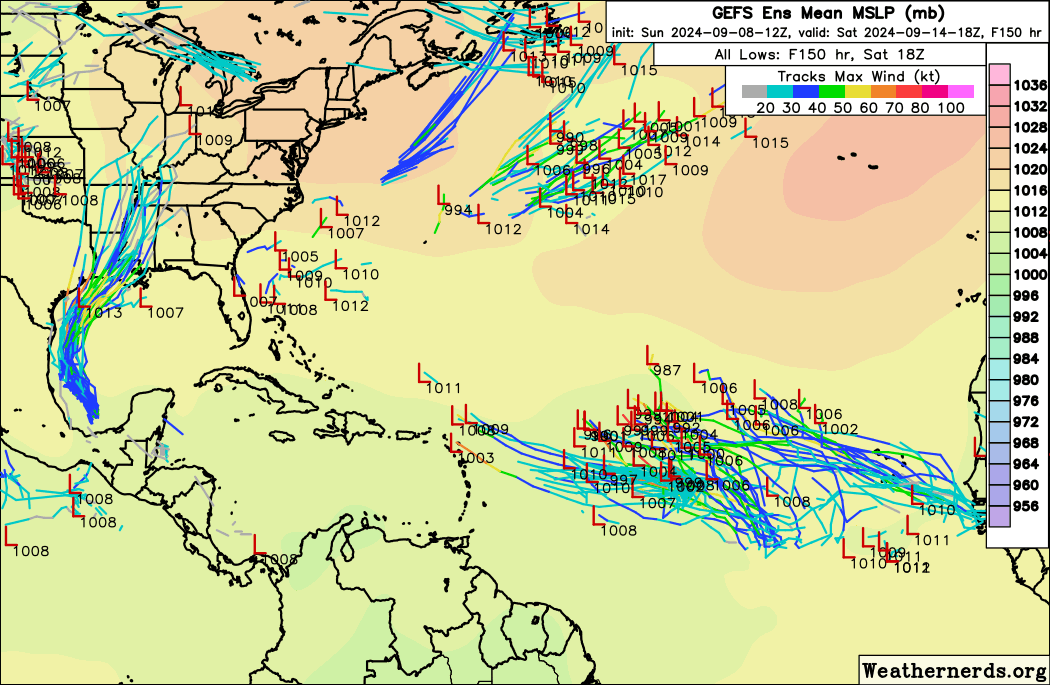
Haven't checked 12z GEFS beyond what Weathernerds shows (I know TT loads them faster), but one interesting thing is that more members are showing the subsequent wave (leaving Africa around 9/10) having 30+ kt winds by itself before interacting with the eastern half of the trough.

At 6 days out, you can see two clusters of blue lines: one moving NNW from Eastern Atlantic (the trough), and one moving WNW from Africa (the wave). Signal for the latter was a lot fainter on earlier runs.

Image
0 likes   

User avatar
Teban54
Category 5
Category 5
Posts: 3168
Joined: Sat May 19, 2018 1:19 pm

Re: Trough of low pressure in East-Central Atiantic / Wave that will emerge from West Africa (0/50)

#15 Postby Teban54 » Sun Sep 08, 2024 2:27 pm

Teban54 wrote:0z Euro continues to be aggressive with this system. At the end of this run, it intensifies from 976 mb to 953 mb within 24 hours. Operational Euro is usually very conservative with intensity, so seeing pressure in the 950s is huge.

0z GFS also peaks this at 952 mb, as this run has the system free of interference from 92L.

Regardless of how many systems come out of MDR (I still think 1 is the most likely), one system will have great potential.

12z Euro is the third full-length run in a row with a hurricane in the 960s, and the second in a row in the 950s. Unlike 0z, it misses the trough and seems to be heading west or WNW at 240 hrs.

12z GFS has a complicated tug-of-war between the eastern trough and the wave that takes days to sort out, and never merges them together. Despite this, the run still makes a recurving hurricane out of the eastern trough, just not as strong.
1 likes   

User avatar
Category5Kaiju
Category 5
Category 5
Posts: 4051
Joined: Thu Dec 24, 2020 12:45 pm
Location: Seattle

Re: Trough of low pressure in East-Central Atiantic / Wave that will emerge from West Africa (0/50)

#16 Postby Category5Kaiju » Sun Sep 08, 2024 4:15 pm

Image

Umm...
0 likes   
Unless explicitly stated, all info in my posts is based on my own opinions and observations. Tropical storms and hurricanes can be extremely dangerous. Do not think you can beat Mother Nature. Refer to an accredited weather research agency or meteorologist if you need to make serious decisions regarding an approaching storm.

User avatar
MetroMike
Category 4
Category 4
Posts: 941
Joined: Sun Aug 29, 2004 8:13 pm
Location: Tampa Bay
Contact:

Re: Trough of low pressure in East-Central Atiantic / Wave that will emerge from West Africa (0/50)

#17 Postby MetroMike » Sun Sep 08, 2024 5:04 pm

I thought this was 92L that the Euro is aggressive with developing?
0 likes   

User avatar
Hammy
Category 5
Category 5
Posts: 5849
Age: 41
Joined: Fri May 25, 2012 5:25 pm
Contact:

Re: Trough of low pressure in East-Central Atiantic / Wave that will emerge from West Africa (0/50)

#18 Postby Hammy » Sun Sep 08, 2024 5:37 pm

MetroMike wrote:I thought this was 92L that the Euro is aggressive with developing?


I think the models are all struggling to figure out how this is going to play out, given the monsoon and it seems 3-4 low centers that are going to develop. Seems like the same business we often see with the CAG where they keep alternating between Caribbean, Gulf, and Pacific or simply not at all from run to run
1 likes   
The above post is not official and should not be used as such. It is the opinion of the poster and may or may not be backed by sound meteorological data. It is not endorsed by any professional institution or storm2k.org. For official information, please refer to the NHC and NWS products.

MarioProtVI
Category 4
Category 4
Posts: 932
Age: 23
Joined: Sun Sep 29, 2019 7:33 pm
Location: New Jersey

Re: Low pressure trough in Central Atiantic/Tropical Wave Near the Coast of Africa (0/60)

#19 Postby MarioProtVI » Mon Sep 09, 2024 1:14 am

Euro broadens this out to hell and basically drops it because it’s too weak to reorganize.
0 likes   

User avatar
Teban54
Category 5
Category 5
Posts: 3168
Joined: Sat May 19, 2018 1:19 pm

Re: Low pressure trough in the Central Atlantic/Tropical Wave Near the Coast of Africa (0/60)

#20 Postby Teban54 » Mon Sep 09, 2024 1:58 am

Up to 0/60.

2. Eastern and Central Tropical Atlantic:
A trough of low pressure located several hundred miles
west-southwest of the Cabo Verde Islands is producing a broad area
of disorganized showers and thunderstorms. In a couple of days, this
trough is expected to interact with an approaching tropical wave.
Thereafter, Environmental conditions appear favorable for gradual
development of this system, and a tropical depression could form
during the middle to latter part of this week while the system moves
west-northwestward at 10 to 15 mph.
* Formation chance through 48 hours...low...near 0 percent.
* Formation chance through 7 days...medium...60 percent.
0 likes   


Return to “Talkin' Tropics”

Who is online

Users browsing this forum: zzzh and 90 guests