sphelps8681 wrote:When will we know more info on future track? Thanks
The first advisory will be issued at 21z. Will have a Cat 1 into Lake Charles area on Wednesday night.
Moderator: S2k Moderators
sphelps8681 wrote:When will we know more info on future track? Thanks

Teban54 wrote:So we now have two LLCs or vorts each with its own robust hot towers... This is gonna be fun.
https://i.postimg.cc/zvd1NCJH/image.png


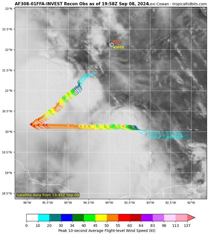
wxman57 wrote:I'm thinking PTC Six shortly. Not a well-defined or organized circulation.
psyclone wrote:Will hurricane and storm surge watches be issued on advisory 1? My guess is yes. I think a hurricane landfall is more likely than not

wxman57 wrote:I'm thinking PTC Six shortly. Not a well-defined or organized circulation.

Steve wrote:Craters wrote:ColdMiser123 wrote:
Those front-related winds are helping to spark the circulation center via shear vorticity. The center will then begin to strengthen the pressure gradient to the southwest as it becomes better defined. So a bit of a chain reaction/positive feedback process taking place with this situation.
ColdMiser, Wxman, et al. -- How much will that shear help (hurt?) in pulling in that dry air to the west? I hate to keep harping on dry air here, but it's a factor that seems to be low on the list of interesting things to talk about. It's saved our bacon before, so I don't want to ignore it.
I don’t think the dry air matters that much because it’s an enhancing wind blowing in the right direction for a circulation forming to its east. Jmo.
texsn95 wrote:What could cause this to go a little farther east, more towards the tip of Louisiana?
wxman57 wrote:I'm thinking PTC Six shortly. Not a well-defined or organized circulation.
Craters wrote:Steve wrote:Craters wrote:ColdMiser, Wxman, et al. -- How much will that shear help (hurt?) in pulling in that dry air to the west? I hate to keep harping on dry air here, but it's a factor that seems to be low on the list of interesting things to talk about. It's saved our bacon before, so I don't want to ignore it.
I don’t think the dry air matters that much because it’s an enhancing wind blowing in the right direction for a circulation forming to its east. Jmo.
RIght, Steve, I got that part, but other posters during other storms have made the point that shear can help the intrusion of dry air into the circulation. I'm not real clear as to why shear is necessary for that, but this looks like it could be that kind of situation, maybe. Soooo, my thinking is that, yes, the winds are in the right direction to help the circulation develop, but would that come at the price of advecting more dry air into the system? I guess if I understood why shear helps in the first place, I wouldn't be asking weird stuff like this. Duh.
Frank P wrote:Per the NHC for PTC 6 some interesting comments. "The track guidance this cycle shifted east, with the GFS and ECMWF models notably on the east side of the guidance envelope. The initial NHC track forecast won't go quite that far east but splits the difference between the consensus aid TVCN and these eastward model solutions. FUTURE ADJUSTMENT could be necessary if these EASTWARD TRENDS CONTINUE. Given the current structure, the track forecast is of LOWER CONFIDENCE than usual." Track errors 4 day out are 125 miles
IcyTundra wrote:They are forecasting a 65 kt hurricane to make landfall near the TX/LA border in 72 hours. Still time for things to change in regards to track and intensity though.


Users browsing this forum: No registered users and 123 guests


