How to read vortex messagesURNT12 KWBC 302307
VORTEX DATA MESSAGE AL022024 < - Atlantic second named storm of 2024
A. 30/22:20:31Z <- for June 30th(day) at 22:20:31z(time)...DATE AND TIME OF FIX
B. 11.14 deg N 056.84 deg W <--for lat and log... LOCATION OF THE VORTEX CENTER
C. 700 MB 2796 m <---pressure height for 700 mb's. MINIMUM HEIGHT AT STANDARD LEVEL. Standard level refers to certain "slices" of the atmosphere used by meteorologists around the world. The exact altitude of each of these slices relates to the pressure
D. 961 mb <--- surface pressure
E. 205 deg 30 kt -<-- wind at 205 degrees at 30 knots. DROPSONDE CENTER WIND SPEED AND DIRECTION
F. CLOSED <---eye wall closed. The state of the eyewall! This is a brief description of what the eye looks like on radar.
G. C10 <-- shape and width of the eye. circular at 10 nmi's.. C-circular; CO-concentric; E-elliptical and all diameters are transmitted in nautical miles.
H. NA <--ESTIMATE OF MAXIMUM SURFACE WIND SPEED OBSERVED ON INBOUND LEG (IN KNOTS)
I. NA <---BEARING, RANGE, AND TIME OF THE WIND SPEED OBSERVED IN ITEM H
J. 016 deg 107 kt <---MAXIMUM INBOUND FLIGHT-LEVEL WIND SPEED AND DIRECTION
K. 298 deg 9 nm 22:18:16Z <--BEARING, RANGE, AND TIME OF THE WIND OBSERVED IN ITEM J
L. NA <-- ESTIMATE OF MAXIMUM SURFACE WIND SPEED OBSERVED WHILE FLYING OUTBOUND (IN KNOTS)
M. NA <---BEARING, RANGE, AND TIME OF THE WIND SPEED OBSERVED IN ITEM L
N. 252 deg 94 kt<---The highest wind speed in knots (and its direction) observed while flying outbound from the storm's center.
O. 150 deg 4 nm 22:21:23Z <--BEARING, RANGE, AND TIME OF THE WIND OBSERVED IN ITEM N. So 150 degrees by 4nmiles at 22:21z
P. 10 C / 3056 m <---This gives an idea of the general temperature surrounding the eye. "Standard" temperature at 700 mb
Q. 23 C / 3040 m <---MAXIMUM FLIGHT-LEVEL TEMPERATURE / PRESSURE ALTITUDE INSIDE THE EYE
R. 5 C / NA <--DEW POINT TEMPERATURE / SEA SURFACE TEMPERATURE INSIDE THE EYE
S. 12345 / 7 <--The first string of numbers indicates what the meteorologist used to find the center of the storm, using numbers 1 through 5, as follows: 1-Penetration, 2-Radar, 3-Wind, 4-Pressure, 5-Temperature. After the solidus ("/"), you'll find one or two numbers which show at what level(s) the center was found, as follows: 0-surface, 1-1500 ft, 8-850 mb, 7-700 mb, 5-500 mb, 4-400 mb, 3-300 mb, 2-200 mb, 9-925 mb.
T. 0.01 / 2 nm <--These numbers give an estimate of how accurate the position is, in nautical miles. "Navigation accuracy" is a gauge of how well the navigation equipment is operating.
U. NOAA2 0302A BERYL OB 05 ->REMARKS SECTION
MAX FL WIND 107 KT 298 / 9 NM 22:18:16Z
https://learningweather.psu.edu/node/66==========
URNT12 KNHC 241133
VORTEX DATA MESSAGE AL162016
A. 24/11:12:50Z
B. 10.97 deg N 082.77 deg W
C. 700 mb 2927 m
D. 977 mb
E. 210 deg 11 kt
F. CLOSED
G. C20
H. 90 kt
I. 144 deg 5 nm 11:07:00Z
J. 253 deg 78 kt
K. 158 deg 8 nm 11:07:30Z
L. 95 kt
M. 314 deg 5 nm 11:17:00Z
N. 033 deg 108 kt
O. 349 deg 14 nm 11:17:30Z
P. 10 C / 3042 m
Q. 18 C / 3045 m
R. NA / NA
S. 12345 / 7
T. 0.02 / 1 nm
U. AF301 0616A OTTO OB 13
MAX FL WIND 108 KT 349 / 14 NM 11:17:00Z
URNT12 KWBC 302307
VORTEX DATA MESSAGE AL162016The first line of the message is the code used to identify a vortex message in various meteorological databases, followed by the date and time (Zulu) the message was transmitted.
A. 24/11:12:50ZThe time when the center of the storm was located or "fixed". 24/11:12:50Z means the report is from the 24th day of the month, at 11:12:50Z (hours:minutes:seconds of Zulu time).
B. 10.97 deg N 082.77 deg WLatitude and Longitude of the vortex fix in decimal degrees. 10.97 deg N 082.77 deg W means 10.97 degrees North latitude, 82.77 degrees West longitude. This information can be used to plot the latest location of the storm center; comparing the current position to previous positions gives the recent movement of the storm.
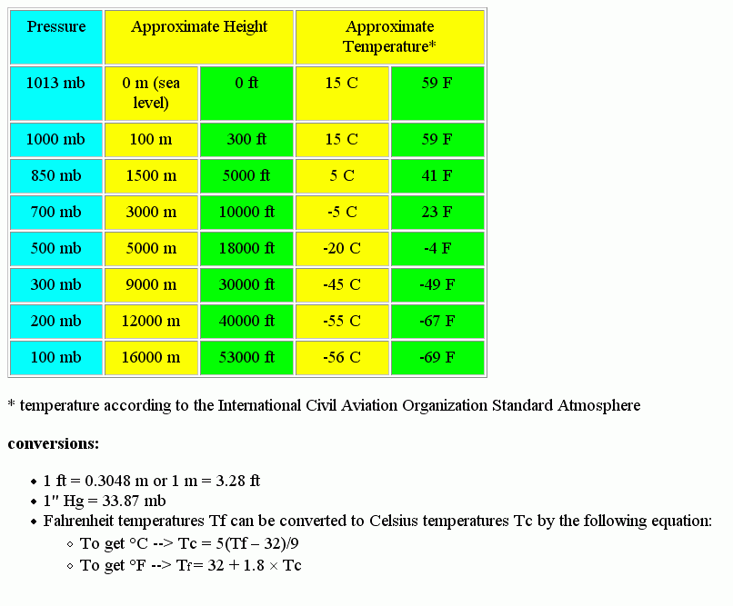
C. 700 mb 2927 mStandard level refers to certain "slices" of the atmosphere used by meteorologists around the world. The exact altitude of each of these slices relates to the pressure. The lower this height is below the "standard" height indicates how low the pressure is inside the hurricane; stronger storms tend to have lower pressures. The number reported is in meters. Hurricane Hunters fly storms at the "surface" (500 to 1500 feet above the water), 925 millibars (2500 feet or 762 meters), 850 mb (4780 ft or 1457 m), or 700 mb (9880 ft or 3011 m).
D. 977 mbThis value, computed from dropsonde or extrapolation, is one of the key pieces of information which indicates the intensity of the storm. "Standard" sea-level pressure is 1013 millibars. Since hurricanes, tropical storms, and tropical depressions are all low-pressure systems, the pressure reported here is almost always lower than standard. The lower the pressure, the more intense the storm. The word "EXTRAP" precedes any pressures extrapolated from aircraft sensor information; if the word "EXTRAP" is not there, it means the pressure was measured directly by a dropsonde released from the aircraft, and is usually more accurate. This lowest pressure is found in the center of the storm, and in this case it was 977 mb. There may be small fluctuations in pressure due to normal, daily pressure rises and falls.
E. 210 deg 11 ktThe wind direction (in degrees) and speed (in knots) at the center of the storm as measured by dropsonde. In this case, winds were from 210 degrees (south-southwest) at 11 knots. In well-developed tropical cyclones, winds at the center will typically be fairly weak compared to the much faster winds found in the eyewall.
F. CLOSEDThis is a brief description of what the eye looks like on radar. "CLOSED" means that the eye is completely surrounded by a ring of thunderstorms. "OPEN NE" means there is a break in the eyewall to the northeast, etc. If the eye is not at least 50% surrounded by eyewall clouds, this item and Item G will be reported as "NA" (Not Applicable).
G. C20Eye shapes are coded as follows: C-circular; CO-concentric; E-elliptical and all diameters are transmitted in nautical miles. In this case, "C20" translates to a circular eye with a diameter of 20 nautical miles. Orientation of major axis of an ellipse is transmitted in tens of degrees. Example: E09/15/5 means elliptical eye oriented with major axis through 90 degrees (and also 270 degrees), with length of major axis 15 nautical miles, and length of minor axis 5 nautical miles. CO8-14 means concentric eye with inner eye diameter 8 nautical miles, and outer diameter 14 nautical miles. The "healthiest" hurricanes usually have a small, circular eye. A concentric eye (a ring inside a ring) is a relatively rare phenomenon that may signal a temporary weakening while the storm reorganizes (which we'll explore later in the course). An eye diameter that shrinks (compared to the previous vortex message) may signal intensification: just as a twirling ice skater spins faster as she pulls in her arms, a hurricane may "spin" faster as its eye gets smaller. Eye diameters are usually 10-20 nautical miles, while we sometimes see them as small as 5 nautical miles to as large as 60 nautical miles.
Eye shape is reported using codes where
C = circular, CO = concentric and E = elliptical. H. 90 kt90 kt means the highest maximum sustained surface wind speed is 90 knots on this particular inbound leg. In the modern era, a Stepped Frequency Microwave Radiometer(link is external) takes this measurement (I'll discuss how this instrument operates later in this lesson).
I. 144 deg 5 nm 11:07:00ZThe "bearing" is the direction (given in degrees) from the center in which the maximum surface wind speed was recorded (similar to compass headings, except these bearings are in reference to "true" instead of "magnetic" north). Due north is 0 degrees, east is 90 degrees, south is 180 degrees, and west is 270 degrees. The bearing in the example is 144 degrees, which means the surface wind speed was recorded southeast of the center. To pinpoint where this was, you also need to know how far away it was: the "range". In this case, the 90 knot wind reported in part H was found 5 nautical miles (about 6 statute miles) southeast of the center at 11:07:00Z (11:07Z exactly).
J. 253 deg 78 ktThe highest wind speed in knots (and its direction) observed on the last leg inbound to the storm. These winds are at flight level, and were measured directly by the aircraft's instruments. In the example, the peak wind was 253 degrees, 78 knots, which means the wind was blowing from a direction of 253 deg (west-southwest) at a speed of 78 kts (about 90 miles per hour).
K. 158 deg 8 nm 11:07:30ZSame method as reporting bearing, range, and time for the surface winds (see Item I, above). In this example, the 78 knot flight-level wind speed reported in Item J was found 158 degrees (south-southeast) of the center, and 8 nautical miles from the center at 11:07:30Z (in this case, that's 30 seconds after the maximum surface wind speed was observed). Usually the strongest winds are found in the "eyewall" surrounding the eye (if there is an eye), and this gives an idea of how large the center (or eye) of the storm is.
L. 95 kt95 kt means the highest maximum sustained surface wind speed estimated while flying outbound from the storm center is 95 knots. Estimates are made in the same fashion as those in Item H.
M. 314 deg 5 nm 11:17:00ZSame method as reporting bearing, range, and time for previous wind observations. In this example, the 95 knot estimated surface wind occurred 314 degrees (northwest) of the center, and 5 nautical miles from the center at 11:17:00Z (exactly 1117Z).
N. 033 deg 108 ktThe highest wind speed in knots (and its direction) observed while flying outbound from the storm's center. These winds are at flight level, and were measured directly by the aircraft's instruments. In the example, the peak wind was 33 degrees at 108 knots, which means the wind was blowing from a direction of 33 degrees (northeast) at a speed of 108 kts (about 124 miles per hour).
O. 349 deg 14 nm 11:17:30ZSame method as reporting bearing, range, and time for previous wind observations. In this example, the 108-knot flight-level wind occurred 349 degrees (north-northwest) of the center, and 14 nautical miles from the center at 11:17:30Z (that's 30 seconds after the maximum surface wind speed was observed while flying outbound).
P. 10 C / 3042 mThis gives an idea of the general temperature surrounding the eye. "Standard" temperature at 700 mb (where we fly most hurricanes) is about -5 degrees Celsius, but in the tropics, it's usually 10 to 15 degrees warmer than "standard". What you especially want to look for is how it compares to the temperature inside the eye, in Item Q. The example shows a temperature of 10 degrees Celsius (50 degrees Fahrenheit) at an altitude of 3042 meters (9,980 feet). The altitude is included because the airplane bumps up and down due to turbulence and other factors, and minor changes in the temperature may be due to changes in altitude
Q. 18 C / 3045 mThis is yet another indicator of how "healthy" the storm is. One of the unusual features of a hurricane is that it is warmer inside the eye than outside. What you want to look for here is how much warmer it is than the temperature reported outside the eye in Item "P." A developing storm may be only slightly warmer inside the center, while a strong hurricane may be 10 degrees warmer (or more). In this example, the eye temperature of 18 degrees Celsius (64 degrees Fahrenheit) is eight degrees Celsius higher than the temperatures immediately outside the eye. Be sure to look at the remarks in Item "U" to see if there was an even warmer temperature found inside the eye (but more than 5 miles from the fix position). The aircraft was at a pressure altitude of 3045 meters (9,990 feet).
R. NA / NAIf available, the dew point measured at the center of the storm (in degrees Celsius) will be reported here; however, a dew point observation was unavailable in this case, so it was reported as "NA" (not applicable). The second part of Item R is no longer used, as the aircraft do not carry the infrared sensors needed to measure sea surface temperature.
S. 12345 / 7The first string of numbers indicates what the meteorologist used to find the center of the storm, using numbers 1 through 5, as follows: 1-Penetration, 2-Radar, 3-Wind, 4-Pressure, 5-Temperature. After the solidus ("/"), you'll find one or two numbers which show at what level(s) the center was found, as follows: 0-surface, 1-1500 ft, 8-850 mb, 7-700 mb, 5-500 mb, 4-400 mb, 3-300 mb, 2-200 mb, 9-925 mb.
Example: 12345/7 means the fix was determined by all five means: penetration, radar, winds, pressure, and temperature. The fix was made at 700 mb (approx 10,000 feet). If a calm spot was seen on the surface of the water, the fix level could have been "07" to indicate the surface and the 700 mb center were found within 5 nautical miles of each other
T. 0.02 / 1 nmThese numbers give an estimate of how accurate the position is, in nautical miles. "Navigation accuracy" is a gauge of how well the navigation equipment is operating (within 0.02 nautical miles, in this case). The "Meteorological Accuracy" depends on how well the storm center can be defined by the meteorological data: if there is a sudden, sharp wind shift, and the temperature peak and pressure drop all coincide, the meteorological accuracy will be a small number. A weaker storm will probably have a larger meteorological accuracy. In this case, the meteorological accuracy was one nautical mile
U. AF301 0616A OTTO OB 13
MAX FL WIND 108 KT 349 / 14 NM 11:17:00Zhttps://www.lakeeriewx.com/CaseStudies/ ... ssage.html