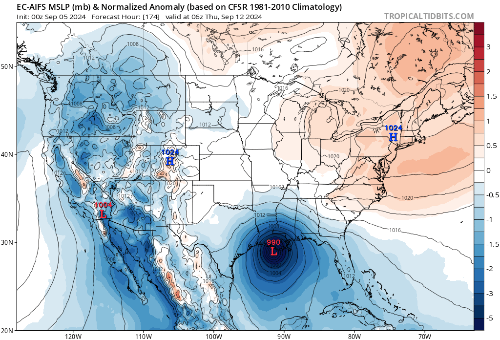
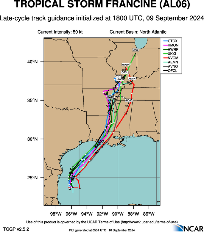
ATL: FRANCINE - Models

Moderator: S2k Moderators

Message
Author
User avatar
NDG
S2K Supporter
S2K Supporter
Posts: 15446
Joined: Sun Jul 09, 2006 10:14 pm
Location: Orlando, FL

Re: ATL: FRANCINE - Models

#141 Postby NDG » Mon Sep 09, 2024 7:17 pm

Steve wrote:
NDG wrote:Both 18z HAFS-A & HAFS-B shifted to the east, HAFS-A looks to track right over Nola.


That’s like southeast of the city. Possibly an outlier? I don’t have a pc at home today so I haven’t looked at the late cycle 18z’s and can only post a link. Oh well. Late cycle not out for 18z yet.


Yes, I would definitely say an outlier.
0 likes   

User avatar
eastcoastFL
Category 5
Category 5
Posts: 3900
Age: 43
Joined: Thu Apr 12, 2007 12:29 pm
Location: Palm City, FL

Re: ATL: FRANCINE - Models

#142 Postby eastcoastFL » Mon Sep 09, 2024 7:22 pm

NDG wrote:Both latest 18z ICON and GFS shifted to the east.

https://i.imgur.com/V2PAwy2.gif


That’s starting to put NOLA in play potentially.
2 likes   
Personal Forecast Disclaimer:
The posts in this forum are NOT official forecast and should not be used as such. They are just the opinion of the poster and may or may not be backed by sound meteorological data. They are NOT endorsed by any professional institution or storm2k.org. For official information, please refer to the NHC and NWS products.

pcolaman
Category 1
Category 1
Posts: 380
Age: 61
Joined: Sun Aug 29, 2010 9:33 am
Location: Pensacola Fla

Re: ATL: FRANCINE - Models

#143 Postby pcolaman » Mon Sep 09, 2024 7:33 pm

Storms this time of year always, well most times trend more NNE
0 likes   

User avatar
gatorcane
S2K Supporter
S2K Supporter
Posts: 23691
Age: 47
Joined: Sun Mar 13, 2005 3:54 pm
Location: Boca Raton, FL

Re: ATL: FRANCINE - Models

#144 Postby gatorcane » Mon Sep 09, 2024 7:40 pm

What a win for the EC-AIFS model, it showed this storm hitting LA as far back as the Sept 5th run!:

Image
3 likes   

User avatar
LadyBug72
Tropical Storm
Tropical Storm
Posts: 117
Joined: Mon Jun 01, 2020 3:39 pm
Location: about 20 miles from Galveston, Tx

Re: ATL: FRANCINE - Models

#145 Postby LadyBug72 » Mon Sep 09, 2024 7:49 pm

Can anyone tell me if the ensembles went to Pensacola, FL?
0 likes   
Formerly known as the user: Nikki

Alicia 83, Allison 01, Rita 05, Ike 08, Harvey 17, Nicholas 21, Coastal Texas Derecho 24, Beryl 24

User avatar
NDG
S2K Supporter
S2K Supporter
Posts: 15446
Joined: Sun Jul 09, 2006 10:14 pm
Location: Orlando, FL

Re: ATL: FRANCINE - Models

#146 Postby NDG » Mon Sep 09, 2024 7:50 pm

No surprise the 0z early models shifted back east.

Image
2 likes   

User avatar
tropicwatch
Category 5
Category 5
Posts: 3378
Age: 61
Joined: Sat Jun 02, 2007 10:01 am
Location: Panama City Florida
Contact:

Re: ATL: FRANCINE - Models

#147 Postby tropicwatch » Mon Sep 09, 2024 7:53 pm

NDG wrote:No surprise the 0z early models shifted back east.

https://i.imgur.com/Ucx9GfL.png


Just caught that myself. It included the TVCN as well.
0 likes   
Tropicwatch


Agnes 72', Eloise 75, Elena 85', Kate 85', Charley 86', Florence 88', Beryl 94', Dean 95', Erin 95', Opal 95', Earl 98', Georges 98', Ivan 2004', Arlene 2005', Dennis 2005', Ida 2009' Debby 2012' Irma 2017' Michael 2018'

User avatar
Steve
S2K Supporter
S2K Supporter
Posts: 9617
Joined: Sat Apr 05, 2003 11:41 pm
Location: Not a state-caster

Re: ATL: FRANCINE - Models

#148 Postby Steve » Mon Sep 09, 2024 7:58 pm

Late cycle 18z just loaded too and shows less SWLA than the earlies though not as far east as the early cycles

https://hurricanes.ral.ucar.edu/realtim ... k_late.png
1 likes   

User avatar
Steve
S2K Supporter
S2K Supporter
Posts: 9617
Joined: Sat Apr 05, 2003 11:41 pm
Location: Not a state-caster

Re: ATL: FRANCINE - Models

#149 Postby Steve » Mon Sep 09, 2024 8:02 pm

1 likes   

User avatar
LadyBug72
Tropical Storm
Tropical Storm
Posts: 117
Joined: Mon Jun 01, 2020 3:39 pm
Location: about 20 miles from Galveston, Tx

Re: ATL: FRANCINE - Models

#150 Postby LadyBug72 » Mon Sep 09, 2024 8:05 pm

Steve wrote:
LadyBug72 wrote:Can anyone tell me if the ensembles went to Pensacola, FL?


GEPS
https://www.tropicaltidbits.com/analysi ... 90918&fh=6

GEFS
https://www.tropicaltidbits.com/analysi ... 918&fh=348

EPS
https://www.tropicaltidbits.com/analysi ... 912&fh=390

Have to press play.


Thank you. I saw on a FB weather page they had. Should have known better. :oops:
1 likes   
Formerly known as the user: Nikki

Alicia 83, Allison 01, Rita 05, Ike 08, Harvey 17, Nicholas 21, Coastal Texas Derecho 24, Beryl 24

User avatar
Teban54
Category 5
Category 5
Posts: 3204
Joined: Sat May 19, 2018 1:19 pm

Re: ATL: FRANCINE - Models

#151 Postby Teban54 » Mon Sep 09, 2024 9:25 pm

All four 18z hurricane models correctly predicted dry air entrainment on the eastern half of the system right now. The three of them that correctly forecasted short-term pressure still show a strong Cat 2 or weak Cat 3 peak. (HAFS-A was too weak with current intensity.) They generally expect dry air to be mixed out in 6-12 hours.
4 likes   

User avatar
Blinhart
Category 5
Category 5
Posts: 2079
Age: 48
Joined: Thu Sep 08, 2011 3:13 pm
Location: Crowley, La.

Re: ATL: FRANCINE - Models

#152 Postby Blinhart » Mon Sep 09, 2024 9:34 pm

Teban54 wrote:All four 18z hurricane models correctly predicted dry air entrainment on the eastern half of the system right now. The three of them that correctly forecasted short-term pressure still show a strong Cat 2 or weak Cat 3 peak. (HAFS-A was too weak with current intensity.) They generally expect dry air to be mixed out in 6-12 hours.


This is what I fully expect to have happen. In the next 6-12 hours the core will bring in all the rain from the north in and coalesce and form a very strong core, then when it starts to move NNE away from Mexico it will get stronger and stronger until it finally makes landfall around Pecan Island or a little further East.
1 likes   
Personal Forecast Disclaimer:
The posts in this forum are NOT official forecast and should not be used as such. They are just the opinion of the poster and may or may not be backed by sound meteorological data. They are NOT endorsed by any professional institution or storm2k.org. For official information, please refer to the NHC and NWS products.

User avatar
Steve
S2K Supporter
S2K Supporter
Posts: 9617
Joined: Sat Apr 05, 2003 11:41 pm
Location: Not a state-caster

Re: ATL: FRANCINE - Models

#153 Postby Steve » Mon Sep 09, 2024 9:36 pm

Teban54 wrote:All four 18z hurricane models correctly predicted dry air entrainment on the eastern half of the system right now. The three of them that correctly forecasted short-term pressure still show a strong Cat 2 or weak Cat 3 peak. (HAFS-A was too weak with current intensity.) They generally expect dry air to be mixed out in 6-12 hours.


NAM 0z’s have it too.
0 likes   

User avatar
PTrackerLA
Category 5
Category 5
Posts: 5277
Age: 41
Joined: Thu Oct 10, 2002 8:40 pm
Location: Lafayette, LA

Re: ATL: FRANCINE - Models

#154 Postby PTrackerLA » Mon Sep 09, 2024 10:45 pm

00z GFS rolling now. With the east shift at 18z but NHC only shifting east to be directly over Lafayette again this is a critical run for my local interests. Will update accordingly.
1 likes   

User avatar
Cunxi Huang
Category 1
Category 1
Posts: 329
Age: 27
Joined: Thu Sep 26, 2013 12:17 pm
Location: San Jose, CA
Contact:

Re: ATL: FRANCINE - Models

#155 Postby Cunxi Huang » Tue Sep 10, 2024 12:17 am

Some spicy 00z HMON here... MH at landfall. :double:

Image
0 likes   
06 SuTY SAOMAI | 09 TY LINFA | 10 TY FANAPI | 10 SuTY MEGI | 16 SuTY MERANTI | 19 SuTY LEKIMA | 24 C2 FRANCINE
DO NOT use my posts for life and death decisions. For official information, please refer to products from your RSMC and national weather agency.

User avatar
Steejo91
Tropical Low
Tropical Low
Posts: 30
Age: 34
Joined: Fri Jul 12, 2019 5:18 pm

Re: ATL: FRANCINE - Models

#156 Postby Steejo91 » Tue Sep 10, 2024 12:43 am

One BIG Takeaway I have with the 00z Hurricane Models tonight is that the FASTER Francine moves, the trend has been STRONGER in the guidance. Looking at the speed of these models having Francine making landfall a little after noon whereas earlier was around 4-6pm.
1 likes   
Tornado Intercept/Hurricane Intercept
Facebook: https://www.facebook.com/TornadoIntercept/
Twitter: @Tornado_Steejo
Instagram: Tornado_Steejo

A follower/member of Storm2k for 14 Years as Weatherfreak14

User avatar
ElectricStorm
Category 5
Category 5
Posts: 5042
Age: 24
Joined: Tue Aug 13, 2019 11:23 pm
Location: Skiatook, OK / Norman, OK

Re: ATL: FRANCINE - Models

#157 Postby ElectricStorm » Tue Sep 10, 2024 12:54 am

All four hurricane models have at least a Cat 2 this cycle, with the HWRF and HMON both having a Cat 3. This is above the rest of the intensity guidance (shown here)
Image

I do think this could peak shortly before landfall before levelling off or perhaps weaken a bit. Still leaning towards a 75-85kt landfall. I'm thinking around a 85-95kt peak for now. Wouldn't necessarily surprise me if it reached 100kts but I think that's unlikely as of now.
0 likes   
B.S Meteorology, University of Oklahoma '25

Please refer to the NHC, NWS, or SPC for official information.

tolakram
Admin
Admin
Posts: 20009
Age: 62
Joined: Sun Aug 27, 2006 8:23 pm
Location: Florence, KY (name is Mark)

Re: ATL: FRANCINE - Models

#158 Postby tolakram » Tue Sep 10, 2024 7:33 am

Morning hurricane model roundup

Image

Image

Image

Image
2 likes   
M a r k
- - - - -
Join us in chat: Storm2K Chatroom Invite. Android and IOS apps also available.

The posts in this forum are NOT official forecasts and should not be used as such. Posts are NOT endorsed by any professional institution or STORM2K.org. For official information and forecasts, please refer to NHC and NWS products.

User avatar
toad strangler
S2K Supporter
S2K Supporter
Posts: 4543
Joined: Sun Jul 28, 2013 3:09 pm
Location: Earth
Contact:

Re: ATL: FRANCINE - Models

#159 Postby toad strangler » Tue Sep 10, 2024 8:20 am

The 0z Euro and the 6z GFS show the beginnings of what would be considerable dry air entrainment right at landfall should it verify as depicted.
Image
Image
0 likes   

tolakram
Admin
Admin
Posts: 20009
Age: 62
Joined: Sun Aug 27, 2006 8:23 pm
Location: Florence, KY (name is Mark)

Re: ATL: FRANCINE - Models

#160 Postby tolakram » Tue Sep 10, 2024 8:34 am

Levi talked about the dry air, the only question is when, not if. Will it just stop strengthening before landfall, weaken before landfall, or of course continue to strengthen all the way in. I would think the hurricane models can model this correctly, otherwise they're crap. :lol:

Here's HAFS-A depiction from the last run

Image

The timing is critical and right now it seems to entrain right at landfall.
0 likes   
M a r k
- - - - -
Join us in chat: Storm2K Chatroom Invite. Android and IOS apps also available.

The posts in this forum are NOT official forecasts and should not be used as such. Posts are NOT endorsed by any professional institution or STORM2K.org. For official information and forecasts, please refer to NHC and NWS products.


Return to “2024”

Who is online

Users browsing this forum: No registered users and 3 guests