
ATL: FRANCINE - Remnants - Discussion
Moderator: S2k Moderators
Re: ATL: FRANCINE - Tropical Storm - Discussion
Just when it looked like convection was waning again, a new burst is lighting up the eyewall.
1 likes
TC naming lists: retirements and intensity
Most aggressive Advisory #1's in North Atlantic (cr. kevin for starting the list)
Most aggressive Advisory #1's in North Atlantic (cr. kevin for starting the list)
-
Janie2006

- Category 5

- Posts: 1329
- Joined: Mon Sep 18, 2006 3:28 pm
- Location: coastal Ms aka home of the hurricanes
Re: ATL: FRANCINE - Tropical Storm - Discussion
Tropical Storm Watch extended eastward to the Perdido River, the border between Alabama and Florida.
0 likes
-
MississippiWx

- S2K Supporter

- Posts: 1720
- Joined: Sat Aug 14, 2010 1:44 pm
- Location: Hattiesburg, Mississippi
Re: ATL: FRANCINE - Tropical Storm - Discussion
ScottNAtlanta wrote:MississippiWx wrote:I’ve seen lots of claims of “dry air”, but what I haven’t seen is any evidence in the cloud pattern of dry air. Normally, thunderstorms collapse and send arch clouds everywhere. I’ve seen none of those. I think there are other factors - just a thought!
Anyway, structure still looks good and on pace for quick strengthening later today and tonight. Kinda crazy that I could end up getting the strongest part of this system when it comes through. Looked well East of here yesterday. Still time to shift back west I suppose.
There were quite a few on the far SE side yesterday. I don't see them today though
I disagree. Those clouds to the southeast were simply convergent cloud streets on the east side of the low.
1 likes
This post is not an official forecast and should not be used as such. It is just the opinion of MississippiWx and may or may not be backed by sound meteorological data. It is not endorsed by any professional institution including storm2k.org. For Official Information please refer to the NHC and NWS products.
Re: ATL: FRANCINE - Tropical Storm - Discussion
Janie2006 wrote:Tropical Storm Watch extended eastward to the Perdido River, the border between Alabama and Florida.
Yeah Janie if the Hurricane models are right could see 45kt gust along the coast? I say just were is that in the atmosphere every storm seems different the last one was 90mph but it was all at the surface.
was using 850mb chart.
Last edited by Javlin on Tue Sep 10, 2024 10:24 am, edited 2 times in total.
0 likes
-
Sciencerocks
- Category 5
- Posts: 10186
- Age: 40
- Joined: Thu Jul 06, 2017 1:51 am

-
ColdFusion

- S2K Supporter
- Posts: 452
- Joined: Wed Feb 13, 2008 3:46 pm
- Location: Addison, TX
Re: ATL: FRANCINE - Tropical Storm - Discussion
MississippiWx wrote:I’ve seen lots of claims of “dry air”, but what I haven’t seen is any evidence in the cloud pattern of dry air. Normally, thunderstorms collapse and send arch clouds everywhere. I’ve seen none of those. I think there are other factors - just a thought!
Anyway, structure still looks good and on pace for quick strengthening later today and tonight. Kinda crazy that I could end up getting the strongest part of this system when it comes through. Looked well west of here yesterday. Still time to shift back west I suppose.
It was mentioned in the NHC discussions yesterday.
0 likes
-
wxman57

- Moderator-Pro Met

- Posts: 23175
- Age: 68
- Joined: Sat Jun 21, 2003 8:06 pm
- Location: Houston, TX (southwest)
Re: ATL: FRANCINE - Tropical Storm - Discussion
Pipelines182 wrote:MississippiWx wrote:I’ve seen lots of claims of “dry air”, but what I haven’t seen is any evidence in the cloud pattern of dry air. Normally, thunderstorms collapse and send arch clouds everywhere. I’ve seen none of those. I think there are other factors - just a thought!
Anyway, structure still looks good and on pace for quick strengthening later today and tonight. Kinda crazy that I could end up getting the strongest part of this system when it comes through. Looked well East of here yesterday. Still time to shift back west I suppose.
I've noticed that a lot of people incorrectly associate lack of convection with "dry air". You're absolutely right, there's been no visible signs of dry air anywhere, not an outflow boundary to be seen.
Not today, yesterday afternoon. That's when the dry air flowed off the coast of MX.
See: https://wxman57.com/images/DryAir.JPG
2 likes
-
MississippiWx
- S2K Supporter
- Posts: 1720
- Joined: Sat Aug 14, 2010 1:44 pm
- Location: Hattiesburg, Mississippi
Re: ATL: FRANCINE - Tropical Storm - Discussion
Looks like at least one hot tower is rotating rapidly around the center. This means a period of intensification has begun. If we see a second hot tower, a period of rapid intensification could be coming. Still, the models predict the quickest strengthening overnight into early tomorrow.
0 likes
This post is not an official forecast and should not be used as such. It is just the opinion of MississippiWx and may or may not be backed by sound meteorological data. It is not endorsed by any professional institution including storm2k.org. For Official Information please refer to the NHC and NWS products.

Re: ATL: FRANCINE - Tropical Storm - Discussion
Texashawk wrote:Crazy that this was originally plotted to make landfall near Beaumont/Sabine Pass. Now, Mississippi might be in play. Feels like both Beryl and Francine made significant East model shifts as time passed. Is it common to have an initial west bias for models in the Gulf or is just normal forecast drift?
Rita and Ike come to mind.
0 likes
Alicia, Rita, Ike, Harvey and Beryl...moved to Splendora lol
-
Nederlander
- S2K Supporter
- Posts: 1259
- Joined: Sat Jul 19, 2008 4:28 pm
- Location: Conroe, TX
Re: ATL: FRANCINE - Tropical Storm - Discussion
wxman57 wrote:Pipelines182 wrote:MississippiWx wrote:I’ve seen lots of claims of “dry air”, but what I haven’t seen is any evidence in the cloud pattern of dry air. Normally, thunderstorms collapse and send arch clouds everywhere. I’ve seen none of those. I think there are other factors - just a thought!
Anyway, structure still looks good and on pace for quick strengthening later today and tonight. Kinda crazy that I could end up getting the strongest part of this system when it comes through. Looked well East of here yesterday. Still time to shift back west I suppose.
I've noticed that a lot of people incorrectly associate lack of convection with "dry air". You're absolutely right, there's been no visible signs of dry air anywhere, not an outflow boundary to be seen.
Not today, yesterday afternoon. That's when the dry air flowed off the coast of MX.
See: https://wxman57.com/images/DryAir.JPG
This is when I started to see it yesterday, but others said it was just lack of convection.

0 likes
Re: ATL: FRANCINE - Tropical Storm - Discussion
wxman57 wrote:Pipelines182 wrote:MississippiWx wrote:I’ve seen lots of claims of “dry air”, but what I haven’t seen is any evidence in the cloud pattern of dry air. Normally, thunderstorms collapse and send arch clouds everywhere. I’ve seen none of those. I think there are other factors - just a thought!
Anyway, structure still looks good and on pace for quick strengthening later today and tonight. Kinda crazy that I could end up getting the strongest part of this system when it comes through. Looked well East of here yesterday. Still time to shift back west I suppose.
I've noticed that a lot of people incorrectly associate lack of convection with "dry air". You're absolutely right, there's been no visible signs of dry air anywhere, not an outflow boundary to be seen.
Not today, yesterday afternoon. That's when the dry air flowed off the coast of MX.
See: https://wxman57.com/images/DryAir.JPG
That is a visible depiction of the storm structure. But dry air is not visible, you need the analysis of the column in order say what the water vapor situation is.
1 likes
-
tolakram
- Admin

- Posts: 20186
- Age: 62
- Joined: Sun Aug 27, 2006 8:23 pm
- Location: Florence, KY (name is Mark)
Re: ATL: FRANCINE - Tropical Storm - Discussion
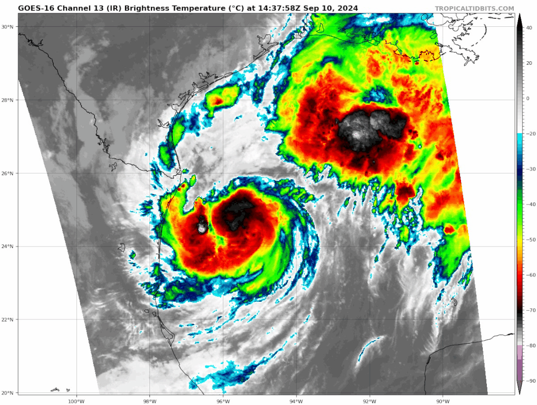
Today this is what Francine looks like. Floater moves, but expanding convection all morning.

0 likes
M a r k
- - - - -
Join us in chat: Storm2K Chatroom Invite. Android and IOS apps also available.
The posts in this forum are NOT official forecasts and should not be used as such. Posts are NOT endorsed by any professional institution or STORM2K.org. For official information and forecasts, please refer to NHC and NWS products.

Re: ATL: FRANCINE - Tropical Storm - Discussion
xironman wrote:wxman57 wrote:Pipelines182 wrote:
I've noticed that a lot of people incorrectly associate lack of convection with "dry air". You're absolutely right, there's been no visible signs of dry air anywhere, not an outflow boundary to be seen.
Not today, yesterday afternoon. That's when the dry air flowed off the coast of MX.
See: https://wxman57.com/images/DryAir.JPG
That is a visible depiction of the storm structure. But dry air is not visible, you need the analysis of the column in order say what the water vapor situation is.
FWIW, dropsondes from the upper-level mission yesterday showed dryness in the mid-levels. On a long TPW loop, it appears to be continental air brought in off Mexico. That's not to say it will preclude future strengthening - models suggest it won't - but it is what happened last night.
2 likes
Kendall -> SLO -> PBC
Memorable Storms: Katrina (for its Florida landfall...) Wilma Matthew Irma
Memorable Storms: Katrina (for its Florida landfall...) Wilma Matthew Irma

-
Drewsey
- Tropical Low

- Posts: 20
- Joined: Fri Jun 05, 2020 7:53 pm
- Location: Raceland, LA (Lafourche Parish)
Re: ATL: FRANCINE - Tropical Storm - Discussion
Just finished boarding the house up here in Central Lafourche and have the generators stashed behind the cars in the garage ready to go. I had a feeling yesterday they would be moving track east and here we are. Actually saw Archie, our parish president, shopping in Walmart (Raceland) this morning. Not sure if he needed supplies or was just getting down in the trenches with his residents.
2 likes
-
Pipelines182
- Tropical Storm

- Posts: 159
- Joined: Tue Jul 02, 2024 8:46 am
Re: ATL: FRANCINE - Tropical Storm - Discussion
Nederlander wrote:wxman57 wrote:Pipelines182 wrote:
I've noticed that a lot of people incorrectly associate lack of convection with "dry air". You're absolutely right, there's been no visible signs of dry air anywhere, not an outflow boundary to be seen.
Not today, yesterday afternoon. That's when the dry air flowed off the coast of MX.
See: https://wxman57.com/images/DryAir.JPG
This is when I started to see it yesterday, but others said it was just lack of convection.
https://i.ibb.co/XSbWvpj/IMG-8103.jpg
It could be due to dry air but not always. Think of it this way, ever been out on a really humid day but there's no rain, just partly cloudy skies? All the moisture in the world won't create thunderstorms unless you have sufficient uplift.
1 likes
-
South Texas Storms

- Professional-Met

- Posts: 4259
- Joined: Thu Jun 24, 2010 12:28 am
- Location: Houston, TX
Re: ATL: FRANCINE - Tropical Storm - Discussion
mpic wrote:Texashawk wrote:Crazy that this was originally plotted to make landfall near Beaumont/Sabine Pass. Now, Mississippi might be in play. Feels like both Beryl and Francine made significant East model shifts as time passed. Is it common to have an initial west bias for models in the Gulf or is just normal forecast drift?
Rita and Ike come to mind.
Definitely. When systems in the Gulf are getting picked up by troughs they almost always come in farther north/east than the models indicate days in advance.
1 likes
Re: ATL: FRANCINE - Tropical Storm - Discussion
Ubuntwo wrote:xironman wrote:wxman57 wrote:
Not today, yesterday afternoon. That's when the dry air flowed off the coast of MX.
See: https://wxman57.com/images/DryAir.JPG
That is a visible depiction of the storm structure. But dry air is not visible, you need the analysis of the column in order say what the water vapor situation is.
FWIW, dropsondes from the upper-level mission yesterday showed dryness in the mid-levels. On a long TPW loop, it appears to be continental air brought in off Mexico. That's not to say it will preclude future strengthening - models suggest it won't - but it is what happened last night.
There was 30kts of shear at that time. To ignore that amount of shear for a tropical system could be a mistake.
0 likes
Re: ATL: FRANCINE - Tropical Storm - Discussion
xironman wrote:Ubuntwo wrote:xironman wrote:
That is a visible depiction of the storm structure. But dry air is not visible, you need the analysis of the column in order say what the water vapor situation is.
FWIW, dropsondes from the upper-level mission yesterday showed dryness in the mid-levels. On a long TPW loop, it appears to be continental air brought in off Mexico. That's not to say it will preclude future strengthening - models suggest it won't - but it is what happened last night.
There was 30kts of shear at that time. To ignore that amount of shear for a tropical system could be a mistake.
Current analysis on all models is around 5 knots:

The NHC has also said that it is currently in a low shear environment, and it is vertically stacked. If you are looking at the SSEC shear plots, outflow shows up as shear. It's not actually feeling 30kt just yet.
0 likes
Kendall -> SLO -> PBC
Memorable Storms: Katrina (for its Florida landfall...) Wilma Matthew Irma
Memorable Storms: Katrina (for its Florida landfall...) Wilma Matthew Irma
Re: ATL: FRANCINE - Tropical Storm - Discussion
South Texas Storms wrote:mpic wrote:Texashawk wrote:Crazy that this was originally plotted to make landfall near Beaumont/Sabine Pass. Now, Mississippi might be in play. Feels like both Beryl and Francine made significant East model shifts as time passed. Is it common to have an initial west bias for models in the Gulf or is just normal forecast drift?
Rita and Ike come to mind.
Definitely. When systems in the Gulf are getting picked up by troughs they almost always come in farther north/east than the models indicate days in advance.
I listened to the tv mets and took me 24 hours to evacuate 90 miles inland for Rita and right in the path of it in Woodville. That's when I found this forum and evacuated for Ike dodging the bullet when it damaged my mobile home after learning a little bit about hurricanes. Still learning.
1 likes
Alicia, Rita, Ike, Harvey and Beryl...moved to Splendora lol
Who is online
Users browsing this forum: No registered users and 28 guests