ATL: GORDON - Models
Moderator: S2k Moderators

ATL: GORDON - Models
This is the system that Euro has been making a long-tracker. On those runs, the Euro has consistently had the system ride the 20N line while staying weak (or not a TC), before intensifying near 50W, just in time to be picked up by a trough and move NE while becoming a major. GFS has been all over the place in recent runs, but there's still good support for the Euro scenario from its ensembles.
Last edited by Teban54 on Tue Sep 10, 2024 1:48 pm, edited 2 times in total.
0 likes
TC naming lists: retirements and intensity
Most aggressive Advisory #1's in North Atlantic (cr. kevin for starting the list)
Most aggressive Advisory #1's in North Atlantic (cr. kevin for starting the list)
-
cycloneye

- Admin

- Posts: 149672
- Age: 69
- Joined: Thu Oct 10, 2002 10:54 am
- Location: San Juan, Puerto Rico
Re: ATL: INVEST 93L - Models
Teban54, I split your post from the discussion thread to create the models one.
12 EURO.

12 EURO.
1 likes
Visit the Caribbean-Central America Weather Thread where you can find at first post web cams,radars
and observations from Caribbean basin members Click Here
and observations from Caribbean basin members Click Here

Re: ATL: INVEST 93L - Models
GFS has a broad low that never develops and seems to be interacting with a front by 210 hours
0 likes
The above post is not official and should not be used as such. It is the opinion of the poster and may or may not be backed by sound meteorological data. It is not endorsed by any professional institution or storm2k.org. For official information, please refer to the NHC and NWS products.
-
ElectricStorm

- Category 5

- Posts: 5150
- Age: 25
- Joined: Tue Aug 13, 2019 11:23 pm
- Location: Norman, OK
Re: ATL: INVEST 93L - Models
Both 0z GFS and CMC show no development, 0z ICON also no development but sends it way west. I'm not really buying that track though. Wouldn't be surprised to see NHC start lowering probs soon.
0 likes
B.S Meteorology, University of Oklahoma '25
Please refer to the NHC, NWS, or SPC for official information.
Please refer to the NHC, NWS, or SPC for official information.
Re: ATL: INVEST 93L - Models
ElectricStorm wrote:Both 0z GFS and CMC show no development, 0z ICON also no development but sends it way west. I'm not really buying that track though. Wouldn't be surprised to see NHC start lowering probs soon.
While 0z GEFS still has a fair number of strong members (on Tropical Tidbits, which sometimes shows lower pressure than the more reliable Weathernerds for ensembles), it's also trending weaker and with further delays in the intensification phase.
Edit: And, just to make things more confusing, 0z Euro (as of 72 hrs at least) shows a similarly organized system as previous runs. It did get weaker at 144 hrs compared to 12z, but I'm using the free EC-fast which has low resolution. I'll check things out tomorrow.
0 likes
TC naming lists: retirements and intensity
Most aggressive Advisory #1's in North Atlantic (cr. kevin for starting the list)
Most aggressive Advisory #1's in North Atlantic (cr. kevin for starting the list)
ATL: SEVEN - Models
12z GFS and CMC still refuse to acknowledge there's a TD out there.  Maybe better luck at 18z...
Edit: 18z GFS does get back to showing a sub-970 mb hurricane. While that's not as strong as some of its earlier monster runs, it's the strongest in a whopping 7 runs. The increased short-term organization probably did play a role in a stronger solution.
Edit: 18z GFS does get back to showing a sub-970 mb hurricane. While that's not as strong as some of its earlier monster runs, it's the strongest in a whopping 7 runs. The increased short-term organization probably did play a role in a stronger solution.
0 likes
TC naming lists: retirements and intensity
Most aggressive Advisory #1's in North Atlantic (cr. kevin for starting the list)
Most aggressive Advisory #1's in North Atlantic (cr. kevin for starting the list)
Re: ATL: SEVEN - Models
12z ICON brings it to 977 mb at the end of the run, while still at 21 N (i.e. barely starting to recurve), unlike recent runs on other models that have it only really get going well into the recurve. It also stalls the system longer and further west than other models as of late.
I would have said this is for entertainment only, but after ICON's stellar performance in the Gulf this season, I'm not so sure.
I would have said this is for entertainment only, but after ICON's stellar performance in the Gulf this season, I'm not so sure.
1 likes
TC naming lists: retirements and intensity
Most aggressive Advisory #1's in North Atlantic (cr. kevin for starting the list)
Most aggressive Advisory #1's in North Atlantic (cr. kevin for starting the list)
Re: ATL: SEVEN - Models
The bifurcation of models on this storm continues. GEFS continues to decrease support for an eventual intensification phase on the recurve, and now virtually every member kills the storm before even moving it north. But EPS and operational Euro continue to show a recurve and intensification along the way, even if not as strong as it was showing days ago. Curiously, the operational GFS agrees with Euro's solution and shows a hurricane in the subtropics (at least more often than not).
I think even NHC alluded to the fact that the Euro suite is basically the only well-established model consistently showing intensification now. On the other hand, it did have the best handle on TD 7 so far.
Edit: Just to make things even more confusing, 0z Euro 9/13 is much further west and slower. (Possibly stronger, too.)
2 likes
TC naming lists: retirements and intensity
Most aggressive Advisory #1's in North Atlantic (cr. kevin for starting the list)
Most aggressive Advisory #1's in North Atlantic (cr. kevin for starting the list)
Re: ATL: SEVEN - Models
Having a look at the ensembles of the models at about 150 hours both the GFS and CMC lose it in a mess caused by a low coming off the coast of the US, the EPS keeps a good lock on it so it develops it better.


0 likes
-
cycloneye
- Admin
- Posts: 149672
- Age: 69
- Joined: Thu Oct 10, 2002 10:54 am
- Location: San Juan, Puerto Rico
Re: ATL: GORDON - Models
ICON? 

1 likes
Visit the Caribbean-Central America Weather Thread where you can find at first post web cams,radars
and observations from Caribbean basin members Click Here
and observations from Caribbean basin members Click Here
-
TomballEd
- Category 5
- Posts: 1316
- Age: 62
- Joined: Wed Aug 16, 2023 4:52 pm
- Location: Spring/Klein area, not Tomball
Re: ATL: GORDON - Models
I can see a path to Gordon getting to near Leewards and Puerto Rico, the system stays weak enough to avoid the initial recurve and then strengthen. There is a deep trough on all the Tropical Tidbits ensemble means, digging as deep as Florida. There is a bit of an induced ridge to the E. Or I see no way it affects the mainland US, but it isn't game over for the USVI and Puerto Rico quite yet. That ridging would steer anything that reaches it W.
Working to protect the NE Caribbean, although sheared on visible satellite, the partially exposed LLC looks healthy and there is deep convection. That favors a much earlier recurve, obviously. Or it probably does recurve before it can get anywhere near the NE Caribbean.
1 likes
-
xtyphooncyclonex

- Category 5
- Posts: 3898
- Age: 24
- Joined: Sat Dec 08, 2012 9:07 am
- Location: Cebu City
- Contact:
Re: ATL: GORDON - Models
Just like that... the GFS blows Gordon up to a major this run lol
2 likes
REMINDER: My opinions that I, or any other NON Pro-Met in this forum, are unofficial. Please do not take my opinions as an official forecast and warning. I am NOT a meteorologist. Following my forecasts blindly may lead to false alarm, danger and risk if official forecasts from agencies are ignored.
-
WaveBreaking

- Category 2

- Posts: 727
- Joined: Sun Jun 30, 2024 11:33 am
- Location: US
Re: ATL: GORDON - Models
12Z ICON has Gordon RI-ing into a major while slowly crawling NE at the end of the run.
2 likes
I am NOT a professional meteorologist, so take all of my posts with a grain of salt. My opinions are mine and mine alone.
Re: ATL: GORDON - Models
xtyphooncyclonex wrote:Just like that... the GFS blows Gordon up to a major this run lol
The system that becomes a major appears to split off from the trough it's interacting with, rather than being Gordon, which leads me to believe the stronger model runs are feedback issues from this interaction
0 likes
The above post is not official and should not be used as such. It is the opinion of the poster and may or may not be backed by sound meteorological data. It is not endorsed by any professional institution or storm2k.org. For official information, please refer to the NHC and NWS products.

Re: ATL: GORDON - Models
Hammy wrote:xtyphooncyclonex wrote:Just like that... the GFS blows Gordon up to a major this run lol
The system that becomes a major appears to split off from the trough it's interacting with, rather than being Gordon, which leads me to believe the stronger model runs are feedback issues from this interaction
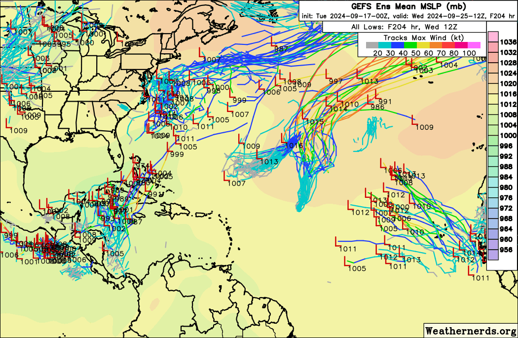
They are referring to the 0z run, which had Gordon itself remaining a discrete entity and intensifying:

The most recent (12z) run shows Gordon dissipating due to shear from the interaction and has a low developing from the trough instead, as you mention:

The second solution definitely does feel a bit like convective feedback. The first might be possible if the trough interaction is properly aligned. The GFS basically has convection going poof over Gordon in a few hours and never really coming back, so I guess we'll see if Gordon is poised to overperform pretty soon.
4 likes
Kendall -> SLO -> PBC
Memorable Storms: Katrina (for its Florida landfall...) Wilma Matthew Irma
Memorable Storms: Katrina (for its Florida landfall...) Wilma Matthew Irma
Re: ATL: GORDON - Models
Lots of uncertainties with Gordon's future intensity:

0 likes
TC naming lists: retirements and intensity
Most aggressive Advisory #1's in North Atlantic (cr. kevin for starting the list)
Most aggressive Advisory #1's in North Atlantic (cr. kevin for starting the list)
Re: ATL: GORDON - Models
In addition to the operational 0z GFS showing the lowest pressure for Gordon that it has for days (981 mb), 0z GEFS also shows a significant uptick in intensity. (As a reminder, a couple days ago virtually all GEFS members insisted on dissipation in the MDR.)
0 likes
TC naming lists: retirements and intensity
Most aggressive Advisory #1's in North Atlantic (cr. kevin for starting the list)
Most aggressive Advisory #1's in North Atlantic (cr. kevin for starting the list)
-
ElectricStorm
- Category 5
- Posts: 5150
- Age: 25
- Joined: Tue Aug 13, 2019 11:23 pm
- Location: Norman, OK
Re: ATL: GORDON - Models
Teban54 wrote:Lots of uncertainties with Gordon's future intensity:
https://i.postimg.cc/bJzCJdvv/image.png
Could be wrong since I haven't been paying attention much today but it seems like guidance is starting to trend upwards a bit. Would love to see this become a nice OTS hurricane but we'll see
0 likes
B.S Meteorology, University of Oklahoma '25
Please refer to the NHC, NWS, or SPC for official information.
Please refer to the NHC, NWS, or SPC for official information.

Re: ATL: GORDON - Models
00z hurricane models. HAFS models are the weakest with a TS at most. HWRF shows a cat 1, but HMON has a MH. So everything is still on the table. A blend would support a recurving low-end cat 1.
HWRF = TS at +51 hrs, initial peak of 979mb/69kt in about 4 days and a secondary peak of 976mb/72kt at the end of the run (+126 hrs).
HMON = TS at +36 hrs, gradually intensifies and peaks as a 954mb/101kt MH at +117 hrs.
HAFS-A = TS at +60 hrs, but doesn't really do much with it afterwards. Peaks at 1000mb/40kt at +60 hrs.
HAFS-B = a weak TS at +80 hrs, a little stronger near the end of the run with 994 mb and 48 kt.
0 likes
Re: ATL: GORDON - Models
12z GFS is the most intense run of the model so far for Gordon. Peaks at 976 mbar at +126 hours. It manages to detach from the low to its west at about +54 hours and becomes a TS almost immediately afterwards.
0 likes
Who is online
Users browsing this forum: No registered users and 119 guests