WPAC: BEBINCA - Remnants

Moderator: S2k Moderators

Message
Author
User avatar
Hayabusa
Category 5
Category 5
Posts: 4346
Joined: Sun Sep 16, 2018 1:05 pm

Re: WPAC: BEBINCA - Tropical Storm

#41 Postby Hayabusa » Tue Sep 10, 2024 5:41 pm

dexterlabio wrote:I can see now why some models are not too aggressive on intensity anymore, since Bebinca is well embedded to this expansive trough. If it manages to separate from it then I think it can truly take off like what the models depicted last week.

Think it has also to do with tracking more west from at least what the Euro was initially showing
0 likes   
ヤンデレ女が寝取られるているのを見たい!!!
ECMWF ensemble NWPAC plots: https://ecmwfensnwpac.imgbb.com/
Multimodel NWPAC plots: https://multimodelnwpac.imgbb.com/
GFS Ensemble NWPAC plots (16 & 35 day forecast): https://gefsnwpac.imgbb.com/
Plots updated automatically

User avatar
xtyphooncyclonex
Category 5
Category 5
Posts: 3861
Age: 23
Joined: Sat Dec 08, 2012 9:07 am
Location: Cebu City
Contact:

Re: WPAC: BEBINCA - Tropical Storm

#42 Postby xtyphooncyclonex » Tue Sep 10, 2024 7:46 pm

JMA now up to 40 kts.

T2413(Bebinca)
Issued at 2024/09/10 21:45 UTC
Analysis at 09/10 21 UTC
Grade TS
Scale -
Intensity -
Center position N13°20′ (13.3°)
E143°35′ (143.6°)
Direction and speed of movement NW 25 km/h (13 kt)
Central pressure 996 hPa
Maximum sustained wind speed near center 20 m/s (40 kt)
Maximum wind gust speed 30 m/s (60 kt)
Radius of 30-kt wind area 220 km (120 NM)
0 likes   
REMINDER: My opinions that I, or any other NON Pro-Met in this forum, are unofficial. Please do not take my opinions as an official forecast and warning. I am NOT a meteorologist. Following my forecasts blindly may lead to false alarm, danger and risk if official forecasts from agencies are ignored.

User avatar
Hayabusa
Category 5
Category 5
Posts: 4346
Joined: Sun Sep 16, 2018 1:05 pm

Re: WPAC: BEBINCA - Tropical Storm

#43 Postby Hayabusa » Tue Sep 10, 2024 7:57 pm

Jma 00z up to STS
1 likes   
ヤンデレ女が寝取られるているのを見たい!!!
ECMWF ensemble NWPAC plots: https://ecmwfensnwpac.imgbb.com/
Multimodel NWPAC plots: https://multimodelnwpac.imgbb.com/
GFS Ensemble NWPAC plots (16 & 35 day forecast): https://gefsnwpac.imgbb.com/
Plots updated automatically

User avatar
xtyphooncyclonex
Category 5
Category 5
Posts: 3861
Age: 23
Joined: Sat Dec 08, 2012 9:07 am
Location: Cebu City
Contact:

Re: WPAC: BEBINCA - Tropical Storm

#44 Postby xtyphooncyclonex » Tue Sep 10, 2024 8:07 pm

Hayabusa wrote:Jma 00z up to STS


With Bebinca intensifying faster than forecast, we could see her actually live up to the model hype. Biggest concern is shear, which looks pretty high to its north.
0 likes   
REMINDER: My opinions that I, or any other NON Pro-Met in this forum, are unofficial. Please do not take my opinions as an official forecast and warning. I am NOT a meteorologist. Following my forecasts blindly may lead to false alarm, danger and risk if official forecasts from agencies are ignored.

User avatar
Hayabusa
Category 5
Category 5
Posts: 4346
Joined: Sun Sep 16, 2018 1:05 pm

Re: WPAC: BEBINCA - Tropical Storm

#45 Postby Hayabusa » Tue Sep 10, 2024 9:22 pm

xtyphooncyclonex wrote:
Hayabusa wrote:Jma 00z up to STS


With Bebinca intensifying faster than forecast, we could see her actually live up to the model hype. Biggest concern is shear, which looks pretty high to its north.

Jtwc 00z downgraded to TD 8-)
1 likes   
ヤンデレ女が寝取られるているのを見たい!!!
ECMWF ensemble NWPAC plots: https://ecmwfensnwpac.imgbb.com/
Multimodel NWPAC plots: https://multimodelnwpac.imgbb.com/
GFS Ensemble NWPAC plots (16 & 35 day forecast): https://gefsnwpac.imgbb.com/
Plots updated automatically

dexterlabio
Category 5
Category 5
Posts: 3468
Joined: Sat Oct 24, 2009 11:50 pm

Re: WPAC: BEBINCA - Tropical Storm

#46 Postby dexterlabio » Tue Sep 10, 2024 9:42 pm

Based on its current look, this is definitely a monsoon depression system :lol: one may argue that there are multiple small circulations under that huge blanket of convection. It will be tricky to crank this storm up to major/STY status IMO.
0 likes   
Personal Forecast Disclaimer:
The posts in this forum are NOT official forecast and should not be used as such. They are just the opinion of the poster and may or may not be backed by sound meteorological data. They are NOT endorsed by any professional institution or storm2k.org. For official information, please refer to the NHC and NWS products.

User avatar
Hayabusa
Category 5
Category 5
Posts: 4346
Joined: Sun Sep 16, 2018 1:05 pm

Re: WPAC: BEBINCA - Tropical Storm

#47 Postby Hayabusa » Tue Sep 10, 2024 9:46 pm

Ascat pass at 00z max 30kts :cheesy:
1 likes   
ヤンデレ女が寝取られるているのを見たい!!!
ECMWF ensemble NWPAC plots: https://ecmwfensnwpac.imgbb.com/
Multimodel NWPAC plots: https://multimodelnwpac.imgbb.com/
GFS Ensemble NWPAC plots (16 & 35 day forecast): https://gefsnwpac.imgbb.com/
Plots updated automatically

User avatar
xtyphooncyclonex
Category 5
Category 5
Posts: 3861
Age: 23
Joined: Sat Dec 08, 2012 9:07 am
Location: Cebu City
Contact:

Re: WPAC: BEBINCA - Tropical Storm

#48 Postby xtyphooncyclonex » Wed Sep 11, 2024 1:50 am

Bebinca having an identity crisis right now. Split between STS and TD :cheesy:
0 likes   
REMINDER: My opinions that I, or any other NON Pro-Met in this forum, are unofficial. Please do not take my opinions as an official forecast and warning. I am NOT a meteorologist. Following my forecasts blindly may lead to false alarm, danger and risk if official forecasts from agencies are ignored.

User avatar
Hayabusa
Category 5
Category 5
Posts: 4346
Joined: Sun Sep 16, 2018 1:05 pm

Re: WPAC: BEBINCA - Tropical Storm

#49 Postby Hayabusa » Wed Sep 11, 2024 3:09 am

Interesting Euro 00z ensembles, that go as far as southern Taiwan, but previous EPS also hinting it...
Image
0 likes   
ヤンデレ女が寝取られるているのを見たい!!!
ECMWF ensemble NWPAC plots: https://ecmwfensnwpac.imgbb.com/
Multimodel NWPAC plots: https://multimodelnwpac.imgbb.com/
GFS Ensemble NWPAC plots (16 & 35 day forecast): https://gefsnwpac.imgbb.com/
Plots updated automatically

User avatar
xtyphooncyclonex
Category 5
Category 5
Posts: 3861
Age: 23
Joined: Sat Dec 08, 2012 9:07 am
Location: Cebu City
Contact:

Re: WPAC: BEBINCA - Tropical Storm

#50 Postby xtyphooncyclonex » Wed Sep 11, 2024 4:10 am

JTWC with a whole 115 kt Cat 4 peak. Not impossible... but it may be difficult
0 likes   
REMINDER: My opinions that I, or any other NON Pro-Met in this forum, are unofficial. Please do not take my opinions as an official forecast and warning. I am NOT a meteorologist. Following my forecasts blindly may lead to false alarm, danger and risk if official forecasts from agencies are ignored.

WALL-E
Tropical Low
Tropical Low
Posts: 30
Joined: Fri Nov 19, 2010 9:12 am
Location: CHINA

Re: WPAC: BEBINCA - Tropical Storm

#51 Postby WALL-E » Wed Sep 11, 2024 12:47 pm

The system is under the affect of wind shear, low level circulation moves faster than the mid level to the northwest, leaving all deep convection behind. As the system intensifying, this issue should be mitigated, with the help of improving upper level outflow.

It has a long way to go on the ocean, and the SST is boiling hot. It can be a STY no doubt.
0 likes   

dexterlabio
Category 5
Category 5
Posts: 3468
Joined: Sat Oct 24, 2009 11:50 pm

Re: WPAC: BEBINCA - Tropical Storm

#52 Postby dexterlabio » Wed Sep 11, 2024 6:06 pm

Looks like there is something interesting going on under that very cold cloud tops...seems to have two VHTs swirling. And overall it's starting to have *that* look, at least to me...
0 likes   
Personal Forecast Disclaimer:
The posts in this forum are NOT official forecast and should not be used as such. They are just the opinion of the poster and may or may not be backed by sound meteorological data. They are NOT endorsed by any professional institution or storm2k.org. For official information, please refer to the NHC and NWS products.

User avatar
xtyphooncyclonex
Category 5
Category 5
Posts: 3861
Age: 23
Joined: Sat Dec 08, 2012 9:07 am
Location: Cebu City
Contact:

Re: WPAC: BEBINCA - Tropical Storm

#53 Postby xtyphooncyclonex » Wed Sep 11, 2024 7:28 pm

Looking much healthier this morning with a clear present circulation and booming cloud tops. Interesting to see the JTWC has a Cat 2 well inland 24 hours from landfall, even with the relatively flat terrain.
0 likes   
REMINDER: My opinions that I, or any other NON Pro-Met in this forum, are unofficial. Please do not take my opinions as an official forecast and warning. I am NOT a meteorologist. Following my forecasts blindly may lead to false alarm, danger and risk if official forecasts from agencies are ignored.

User avatar
Teban54
Category 5
Category 5
Posts: 3204
Joined: Sat May 19, 2018 1:19 pm

Re: WPAC: BEBINCA - Tropical Storm

#54 Postby Teban54 » Wed Sep 11, 2024 8:25 pm

That escalated quickly...

Image
1 likes   

User avatar
Hayabusa
Category 5
Category 5
Posts: 4346
Joined: Sun Sep 16, 2018 1:05 pm

Re: WPAC: BEBINCA - Tropical Storm

#55 Postby Hayabusa » Wed Sep 11, 2024 8:31 pm

2300z ascat 40kt max winds
0 likes   
ヤンデレ女が寝取られるているのを見たい!!!
ECMWF ensemble NWPAC plots: https://ecmwfensnwpac.imgbb.com/
Multimodel NWPAC plots: https://multimodelnwpac.imgbb.com/
GFS Ensemble NWPAC plots (16 & 35 day forecast): https://gefsnwpac.imgbb.com/
Plots updated automatically

User avatar
xtyphooncyclonex
Category 5
Category 5
Posts: 3861
Age: 23
Joined: Sat Dec 08, 2012 9:07 am
Location: Cebu City
Contact:

Re: WPAC: BEBINCA - Tropical Storm

#56 Postby xtyphooncyclonex » Wed Sep 11, 2024 11:55 pm

Forecasts looking very similar to Saomai lately, which was the strongest to hit the east coast of China.
0 likes   
REMINDER: My opinions that I, or any other NON Pro-Met in this forum, are unofficial. Please do not take my opinions as an official forecast and warning. I am NOT a meteorologist. Following my forecasts blindly may lead to false alarm, danger and risk if official forecasts from agencies are ignored.

User avatar
Teban54
Category 5
Category 5
Posts: 3204
Joined: Sat May 19, 2018 1:19 pm

Re: WPAC: BEBINCA - Tropical Storm

#57 Postby Teban54 » Thu Sep 12, 2024 10:36 am


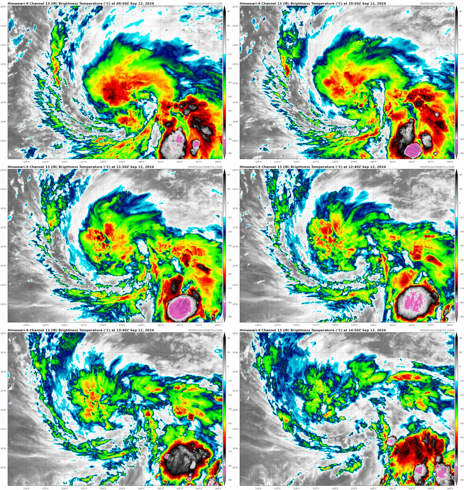
And here comes the feast of crows. Turns out that what I thought was eye-clearing was in fact just dry air (?) and poofing convection.

Image
1 likes   

User avatar
Hayabusa
Category 5
Category 5
Posts: 4346
Joined: Sun Sep 16, 2018 1:05 pm

Re: WPAC: BEBINCA - Tropical Storm

#58 Postby Hayabusa » Thu Sep 12, 2024 5:02 pm

Looks so ugly right now :lol:
0 likes   
ヤンデレ女が寝取られるているのを見たい!!!
ECMWF ensemble NWPAC plots: https://ecmwfensnwpac.imgbb.com/
Multimodel NWPAC plots: https://multimodelnwpac.imgbb.com/
GFS Ensemble NWPAC plots (16 & 35 day forecast): https://gefsnwpac.imgbb.com/
Plots updated automatically

User avatar
xtyphooncyclonex
Category 5
Category 5
Posts: 3861
Age: 23
Joined: Sat Dec 08, 2012 9:07 am
Location: Cebu City
Contact:

Re: WPAC: BEBINCA - Tropical Storm

#59 Postby xtyphooncyclonex » Fri Sep 13, 2024 8:41 pm

From looking like a messed up dessert, she may be looking to finally get her act together. Time and land seem to inhibit what she can further do.
0 likes   
REMINDER: My opinions that I, or any other NON Pro-Met in this forum, are unofficial. Please do not take my opinions as an official forecast and warning. I am NOT a meteorologist. Following my forecasts blindly may lead to false alarm, danger and risk if official forecasts from agencies are ignored.

User avatar
cycloneye
Admin
Admin
Posts: 145249
Age: 68
Joined: Thu Oct 10, 2002 10:54 am
Location: San Juan, Puerto Rico

Re: WPAC: BEBINCA - Tropical Storm

#60 Postby cycloneye » Fri Sep 13, 2024 9:35 pm

Has this storm underperformed? I ask because the models were very bullish with it.
0 likes   
Visit the Caribbean-Central America Weather Thread where you can find at first post web cams,radars
and observations from Caribbean basin members Click Here


Return to “2024”

Who is online

Users browsing this forum: No registered users and 3 guests