#8 Postby cycloneye » Thu Sep 12, 2024 3:55 pm
BULLETIN
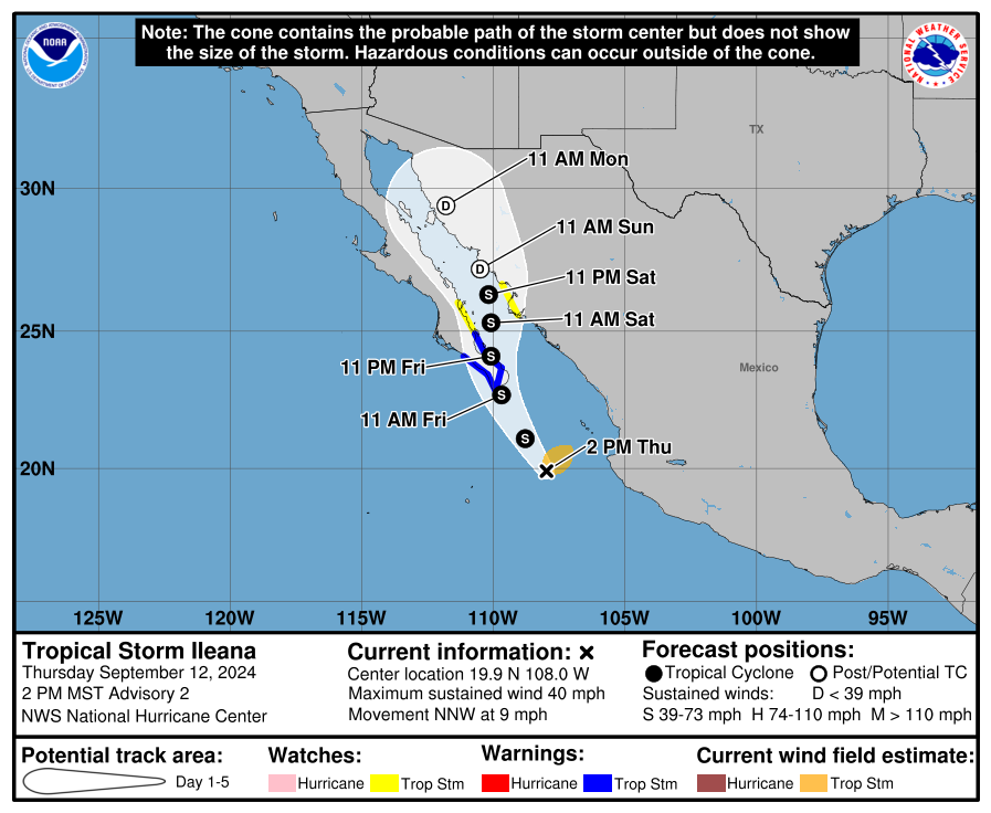
Tropical Storm Ileana Advisory Number 2...Corrected
NWS National Hurricane Center Miami FL EP092024
200 PM MST Thu Sep 12 2024
Corrected for rainfall statement
...DEPRESSION STRENGTHENS TO TROPICAL STORM ILEANA...
...HEAVY RAIN AND FLOODING EXPECTED NEAR THE PATH OF ILEANA
THROUGH THE WEEKEND...
SUMMARY OF 200 PM MST...2100 UTC...INFORMATION
----------------------------------------------
LOCATION...19.9N 108.0W
ABOUT 240 MI...385 KM SSE OF CABO SAN LUCAS MEXICO
MAXIMUM SUSTAINED WINDS...40 MPH...65 KM/H
PRESENT MOVEMENT...NNW OR 340 DEGREES AT 9 MPH...15 KM/H
MINIMUM CENTRAL PRESSURE...1001 MB...29.56 INCHES
WATCHES AND WARNINGS
--------------------
CHANGES WITH THIS ADVISORY:
The government of Mexico has issued a Tropical Storm Warning for
the east coast of the Baja California peninsula from La Paz to San
Evaristo.
The government of Mexico has issued a Tropical Storm Watch for the
east coast of the Baja California Peninsula north of San Evaristo to
Loreto.
The government of Mexico has issued a Tropical Storm Watch for the
coast of mainland Mexico from Topolobampo to Huatabampito.
Tropical Storm Ileana Discussion Number 2
NWS National Hurricane Center Miami FL EP092024
200 PM MST Thu Sep 12 2024
The overall cloud pattern as seen in GOES-18 visible and infrared
imagery does not appear to have changed very much from earlier
today. While the RMW still seems to be a bit large, the cyclone
displays a large area of cold cloud tops with some evidence of
curved banding. The latest subjective Dvorak intensity estimates
are a consensus T-2.5/35 kt from both TAFB and SAB, while recent
objective intensity estimates from UW-CIMSS range from 33 to 42 kt.
Based on the subjective and objective intensity estimates, the
depression is being upgraded to Tropical Storm Ileana with an
initial intensity estimate of 35 kt.
The initial motion estimate is north-northwest, or 340/8 kt, which
is a bit faster than before. The overall synoptic steering pattern
is unchanged in the models from earlier. A deep-layer trough
located over the western United States will continue to steer the
cyclone toward the north-northwest through Friday, bringing the
system near the southern portion of Baja California Sur. After that
time, this trough is forecast to weaken, which should cause steering
currents to weaken. This evolution should induce a slower motion
toward the north, likely over the waters of the southern Gulf of
California. There were no major changes to the guidance for the
first 36 to 48 h of the forecast, and very little change was made to
the previous official forecast. Thereafter, the guidance is a bit
farther west, with some of the models keeping the cyclone moving
north-northwestward over the Gulf of California rather than moving
inland over mainland Mexico. The NHC forecast was only nudged
slightly west of the previous forecast, not as far west as the
consensus aids during the 48 to 96 h time period.
Ileana is currently located within an environment of warm ocean
waters, moderate vertical wind shear, and within a fairly moist low-
to mid-level troposphere. However, very dry air is evident on water
vapor imagery to the northwest of the cyclone. These conditions are
unlikely to change before the cyclone reaches Baja California Sur on
Friday, and the NHC forecast shows some strengthening before then.
Land interaction with the peninsula should cause some weakening.
When the center reaches the Gulf of California, the sea surface
temperatures are quite warm. While some restrengthening is possible
after the cyclone emerges back over water, Ileana will encounter
increasing westerly wind shear and drier air by hour 48, so it won't
have much time to restrengthen. After that time, weakening is
expected as Ileana's convection is sheared off, and the cyclone is
forecast to become a remnant low in about 72 h. It should be noted
that the GFS and ECMWF simulated satellite imagery show the cyclone
becoming a remnant low a bit earlier around hour 60. Although the
cyclone will likely dissipate prior to 96 h, a 96 h point is carried
as a remnant low for continuity.
Key Messages:
1. Tropical Storm Ileana will bring heavy rainfall to portions
of western Mexico and southern Baja California through this weekend.
This heavy rainfall will bring a risk of flash flooding and
mudslides to portions of the area.
2. Tropical storm conditions are expected to begin in portions of
the Baja California Sur on Friday, where Tropical Storm Warnings
are in effect.
FORECAST POSITIONS AND MAX WINDS
INIT 12/2100Z 19.9N 108.0W 35 KT 40 MPH
12H 13/0600Z 21.1N 108.8W 40 KT 45 MPH
24H 13/1800Z 22.7N 109.7W 45 KT 50 MPH
36H 14/0600Z 24.1N 110.1W 40 KT 45 MPH...INLAND
48H 14/1800Z 25.3N 110.1W 40 KT 45 MPH...OVER WATER
60H 15/0600Z 26.3N 110.2W 35 KT 40 MPH
72H 15/1800Z 27.2N 110.5W 30 KT 35 MPH...POST-TROP/REMNT LOW
96H 16/1800Z 29.4N 111.8W 20 KT 25 MPH...POST-TROP/INLAND
120H 17/1800Z...DISSIPATED
$$
Forecaster Hagen
0 likes
Visit the Caribbean-Central America Weather Thread where you can find at first post web cams,radars
and observations from Caribbean basin members
Click Here