2024 Global Model Runs Discussion (Out thru day 16)
Moderator: S2k Moderators
Forum rules

The posts in this forum are NOT official forecasts and should not be used as such. They are just the opinion of the poster and may or may not be backed by sound meteorological data. They are NOT endorsed by any professional institution or STORM2K. For official information, please refer to products from the National Hurricane Center and National Weather Service.
-
Category5Kaiju

- Category 5

- Posts: 4331
- Joined: Thu Dec 24, 2020 12:45 pm
- Location: Seattle and Phoenix
Re: 2024 Global Model Runs Discussion (Out thru day 16)
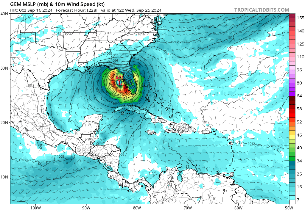
Most recent CMC basically shows an Ian-like storm happening next week. From the same disturbance advertised in the WCAR for the past few days or so
1 likes
Unless explicitly stated, all info in my posts is based on my own opinions and observations. Tropical storms and hurricanes can be extremely dangerous. Refer to an accredited weather research agency or meteorologist if you need to make serious decisions regarding an approaching storm.
-
Weathertracker96
- Tropical Storm

- Posts: 150
- Joined: Mon Oct 16, 2023 3:41 pm
Re: 2024 Global Model Runs Discussion (Out thru day 16)
Category5Kaiju wrote:Most recent CMC basically shows an Ian-like storm happening next week. From the same disturbance advertised in the WCAR for the past few days or so
As of now, what do you think is causing the models to be off on track. I know its early but most models seem way west of the GFS. Is GFS picking up on a new setup in your view?
0 likes

-
TomballEd
- Category 5
- Posts: 1263
- Age: 62
- Joined: Wed Aug 16, 2023 4:52 pm
- Location: Spring/Klein area, not Tomball
Re: 2024 Global Model Runs Discussion (Out thru day 16)
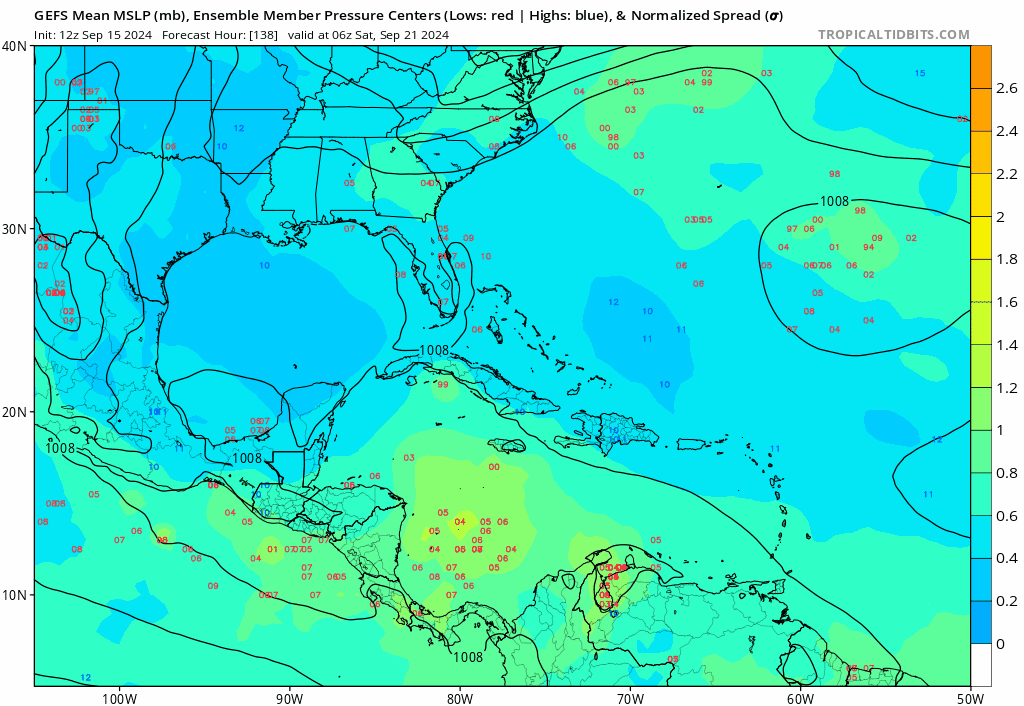
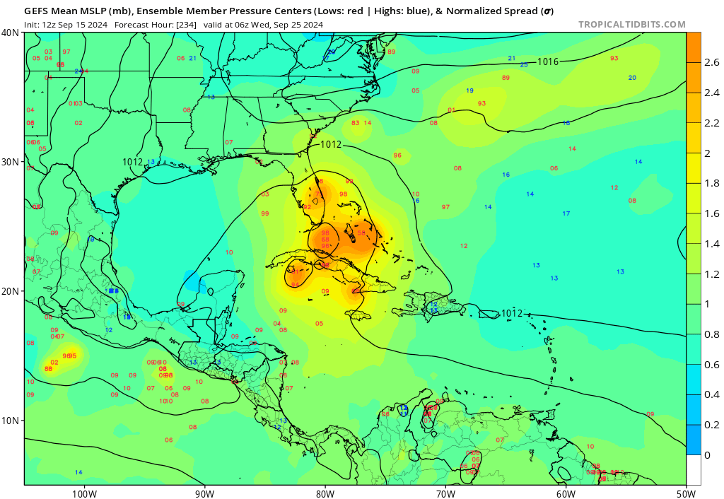
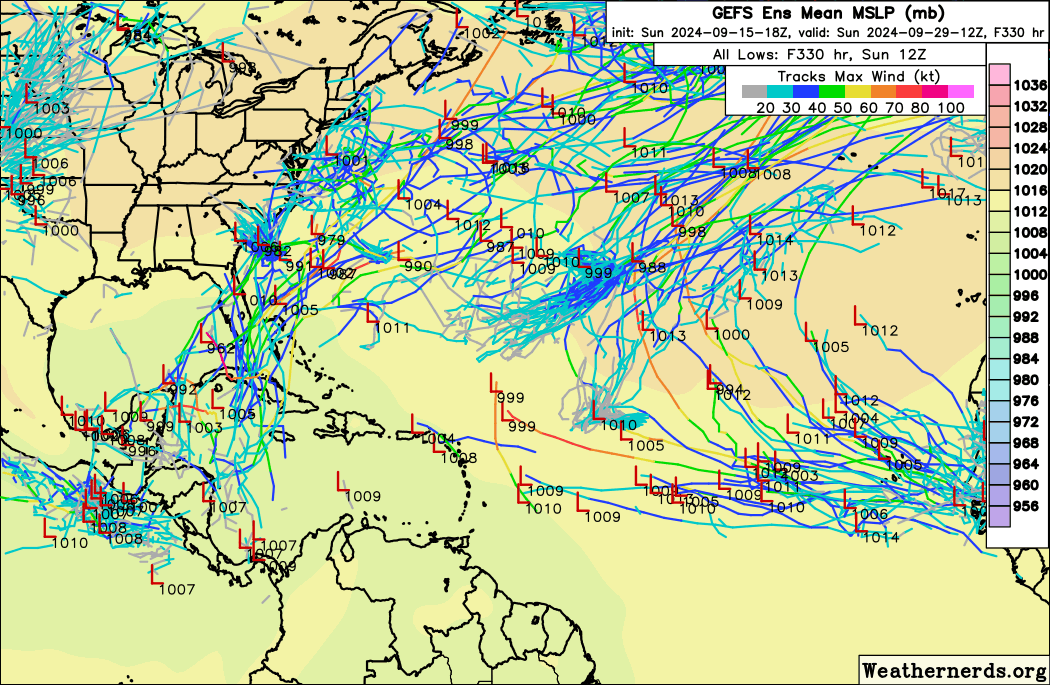
gatorcane wrote:The 12Z GFS ensembles are active:
https://i.postimg.cc/PxqtxNQH/gfs-ememb-lowlocs-watl-fh138-240.gif
Support in 0Z EPS and GEPS as well. Some hurricanes in all 3 ensemble suites, although nothing Ian like. Shear on GEFS ensemble looks favorable for storms in the Caribbean/E MDR but quite hostile in the Gulf. New Canadian is interesting.
Further out, while EUro weekly ACE is well below this week, it then rises to near normal for the period and above normal for the period the first two weeks of October. TC probabilities show highest chances are offshore, although there are periods of 5 to 10% TS probs near the East Coast and Gulf at times. CFS precip anomalies suggest that October could be active in the Caribbean and E. Gulf.
0 likes
-
Category5Kaiju
- Category 5
- Posts: 4331
- Joined: Thu Dec 24, 2020 12:45 pm
- Location: Seattle and Phoenix
Re: 2024 Global Model Runs Discussion (Out thru day 16)
Would be quite something if this becomes the I storm
0 likes
Unless explicitly stated, all info in my posts is based on my own opinions and observations. Tropical storms and hurricanes can be extremely dangerous. Refer to an accredited weather research agency or meteorologist if you need to make serious decisions regarding an approaching storm.
-
jlauderdal
- S2K Supporter

- Posts: 7240
- Joined: Wed May 19, 2004 5:46 am
- Location: NE Fort Lauderdale
- Contact:
Re: RE: Re: 2024 Global Model Runs Discussion (Out thru day 16)
That looks impressive to my untrained, limited experienced eyes.SFLcane wrote:Ok then...
0 likes
-
Hypercane_Kyle

- Category 5
- Posts: 3465
- Joined: Sat Mar 07, 2015 7:58 pm
- Location: Cape Canaveral, FL
Re: 2024 Global Model Runs Discussion (Out thru day 16)
AI-based EURO has been very consistent on a TC in the Caribbean heading to Florida. Absolutely nailed Debby and Francine, too.
2 likes
My posts are my own personal opinion, defer to the National Hurricane Center (NHC) and other NOAA products for decision making during hurricane season.
-
SFLcane

- S2K Supporter
- Posts: 10281
- Age: 48
- Joined: Sat Jun 05, 2010 1:44 pm
- Location: Lake Worth Florida
Re: RE: Re: 2024 Global Model Runs Discussion (Out thru day 16)
jlauderdal wrote:That looks impressive to my untrained, limited experienced eyes.
About a Cat 2 there surely something to watch cmc and Ai have been rather consistent with something heading northward. GEFS/GEPS/signal remains strong
2 likes

Re: 2024 Global Model Runs Discussion (Out thru day 16)
Category5Kaiju wrote:Most recent CMC basically shows an Ian-like storm happening next week. From the same disturbance advertised in the WCAR for the past few days or so
I saw that. Certainly not feel great, especially with Helene likely going to the 95L, leaving the "I" name and this makes particularly more dangerous for some non scientific reason.
For once, I am hoping the GFS verifies or we get an I storm pop before next weekend so where else in the Atlantic Basin and getting a "J' name instead.
Obviously location bias is playing a role for my concern that this could be bad for me and Key West and my family especially my 96 year old grandmom in the St. Pete/Clearwater area...
3 likes
-
Hypercane_Kyle
- Category 5
- Posts: 3465
- Joined: Sat Mar 07, 2015 7:58 pm
- Location: Cape Canaveral, FL
Re: 2024 Global Model Runs Discussion (Out thru day 16)
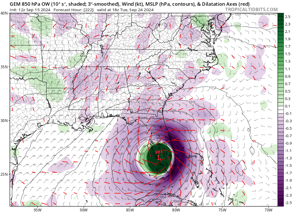
12z EC-AIFS model sticking to its guns with a TC developing in the Caribbean and heading into Florida.
Taking this model very seriously due to its past validations this season.
Taking this model very seriously due to its past validations this season.
1 likes
My posts are my own personal opinion, defer to the National Hurricane Center (NHC) and other NOAA products for decision making during hurricane season.
-
jlauderdal
- S2K Supporter
- Posts: 7240
- Joined: Wed May 19, 2004 5:46 am
- Location: NE Fort Lauderdale
- Contact:
Re: RE: Re: 2024 Global Model Runs Discussion (Out thru day 16)
We havent seen this consitency at this range in a long time, could be consistently wrong.SFLcane wrote::eek:
2 likes
-
SFLcane
- S2K Supporter
- Posts: 10281
- Age: 48
- Joined: Sat Jun 05, 2010 1:44 pm
- Location: Lake Worth Florida
Re: RE: Re: 2024 Global Model Runs Discussion (Out thru day 16)
jlauderdal wrote:We havent seen this consitency at this range in a long time, could be consistently wrong.
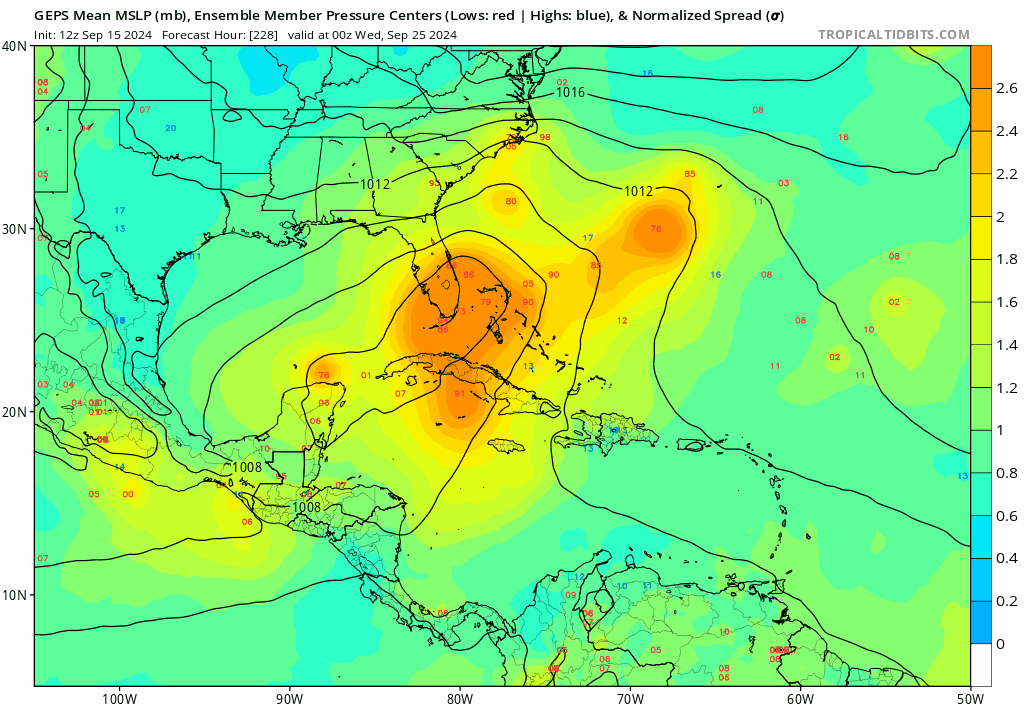
Well its not alone the GEFS also shows something similar. very much intrigued!
1 likes

Re: 2024 Global Model Runs Discussion (Out thru day 16)
In addition to the Caribbean system, GEFS also shows hints of activity in the eastern MDR.
While GFS has shown similar signals for earlier waves occasionally and then backed out of such ideas, I don't recall the earlier signals being asintense (edit: I meant in terms of number of formations, not intensity) as this. On the other hand, the tracks you see on this map come from two different waves, one leaving Africa on 9/23 and another on 9/26. Neither are depicted as very strong systems here, but I'm not sure if it's because of unfavorable conditions or them recurving too early.
While GFS has shown similar signals for earlier waves occasionally and then backed out of such ideas, I don't recall the earlier signals being as
Last edited by Teban54 on Sun Sep 15, 2024 11:51 pm, edited 1 time in total.
0 likes
TC naming lists: retirements and intensity
Most aggressive Advisory #1's in North Atlantic (cr. kevin for starting the list)
Most aggressive Advisory #1's in North Atlantic (cr. kevin for starting the list)
Re: 2024 Global Model Runs Discussion (Out thru day 16)

0 likes
TC naming lists: retirements and intensity
Most aggressive Advisory #1's in North Atlantic (cr. kevin for starting the list)
Most aggressive Advisory #1's in North Atlantic (cr. kevin for starting the list)

Re: 2024 Global Model Runs Discussion (Out thru day 16)
Florida colonoscopy vibes
0 likes
Andy D
(For official information, please refer to the NHC and NWS products.)
(For official information, please refer to the NHC and NWS products.)
Re: 2024 Global Model Runs Discussion (Out thru day 16)
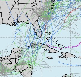
cmc has several runs in a row of a hurricane moving up from the caribbean affecting the west coast of florida.....
0 likes
Re: 2024 Global Model Runs Discussion (Out thru day 16)
When is the origination area supposed to start taking place. How long until we see it on the map?
0 likes
Who is online
Users browsing this forum: gib, mixedDanilo.E and 91 guests