
ATL: GORDON - Remnants - Discussion
Moderator: S2k Moderators
-
Sciencerocks
- Category 5

- Posts: 10189
- Age: 40
- Joined: Thu Jul 06, 2017 1:51 am

Re: ATL: GORDON - Tropical Depression - Discussion
ThomasW wrote:ChrisH-UK wrote:Gordon this morning.
[url]https://imagizer.imageshack.com/img923/424/W0hkex.gif [/url]
Wonder what the odds NHC calls RL over the next day or so are.
Who is RL?
1 likes
-
cycloneye

- Admin

- Posts: 149686
- Age: 69
- Joined: Thu Oct 10, 2002 10:54 am
- Location: San Juan, Puerto Rico
Re: ATL: GORDON - Tropical Depression - Discussion
hipshot wrote:ThomasW wrote:ChrisH-UK wrote:Gordon this morning.
[url]https://imagizer.imageshack.com/img923/424/W0hkex.gif [/url]
Wonder what the odds NHC calls RL over the next day or so are.
Who is RL?
Remnant low.
1 likes
Visit the Caribbean-Central America Weather Thread where you can find at first post web cams,radars
and observations from Caribbean basin members Click Here
and observations from Caribbean basin members Click Here
Re: ATL: GORDON - Tropical Depression - Discussion
cycloneye wrote:hipshot wrote:ThomasW wrote:Wonder what the odds NHC calls RL over the next day or so are.
Who is RL?
Remnant low.
Thks, it seems from the sat image that the LLC is slowing down or the the upper level circulation is catching up a little. Maybe there is
hope yet.
0 likes

Re: ATL: GORDON - Tropical Depression - Discussion
Will this be the start of an epic comeback or just one last desperate attempt at staying alive?
3 likes
TC naming lists: retirements and intensity
Most aggressive Advisory #1's in North Atlantic (cr. kevin for starting the list)
Most aggressive Advisory #1's in North Atlantic (cr. kevin for starting the list)
-
AnnularCane

- S2K Supporter

- Posts: 2964
- Joined: Thu Jun 08, 2006 9:18 am
- Location: Wytheville, VA
Re: ATL: GORDON - Tropical Depression - Discussion
Well...he did apparently strengthen a little bit earlier today.
1 likes
"But it never rained rain. It never snowed snow. And it never blew just wind. It rained things like soup and juice. It snowed mashed potatoes and green peas. And sometimes the wind blew in storms of hamburgers." -- Judi Barrett, Cloudy with a Chance of Meatballs


Re: ATL: GORDON - Tropical Depression - Discussion
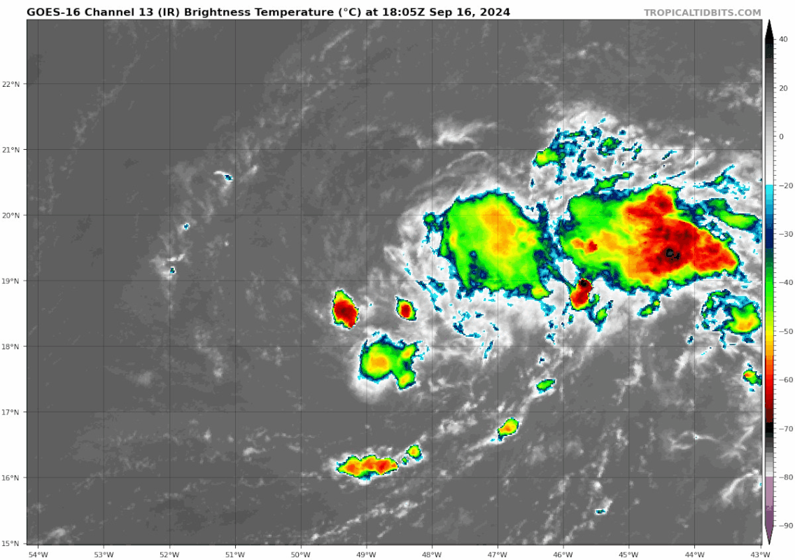
Teban54 wrote:Will this be the start of an epic comeback or just one last desperate attempt at staying alive?
https://i.postimg.cc/P5bMkHj4/goes16-ir-07-L-202409161805.gif
Many storms do this when they're about to produce an "outflow boundary" that opens them up into waves. Maybe not here. we'll see.
1 likes

Re: ATL: GORDON - Tropical Depression - Discussion
ThomasW wrote:Teban54 wrote:Will this be the start of an epic comeback or just one last desperate attempt at staying alive?
https://i.postimg.cc/P5bMkHj4/goes16-ir-07-L-202409161805.gif
Many storms do this when they're about to produce an "outflow boundary" that opens them up into waves. Maybe not here. we'll see.
That tends to happen more with smaller, less robust circulations, and often as a result of collapsing storms if conditions aren't favorable for maintaining convection. Gordon was expected to find improving conditions if it survived the last 24 hours, both less shear and more moisture.
0 likes
The above post is not official and should not be used as such. It is the opinion of the poster and may or may not be backed by sound meteorological data. It is not endorsed by any professional institution or storm2k.org. For official information, please refer to the NHC and NWS products.

Re: ATL: GORDON - Tropical Depression - Discussion
Gordon is turning out to be quite a fighter, it refuses to die. Reminds me somewhat of Kyle in 2002 which had a period of meandering around at tropical depression or weak tropical storm strength for days before finally making landfall. It would be amusing and a little silly if Gordon managed to reach hurricane status after it moves north into the sub-tropics, maintaining the hostile MDR theme this year.
3 likes
-
Sciencerocks
- Category 5
- Posts: 10189
- Age: 40
- Joined: Thu Jul 06, 2017 1:51 am

-
cycloneye
- Admin
- Posts: 149686
- Age: 69
- Joined: Thu Oct 10, 2002 10:54 am
- Location: San Juan, Puerto Rico
Re: ATL: GORDON - Remnants - Discussion
Is now a remanant low, but it may regenerate.
. NHC
will continue to monitor the remnants of Gordon for signs of
organization and the possibility of redevelopment later this week.
Information on the potential for regeneration will be contained in
the Tropical Weather Outlook.
will continue to monitor the remnants of Gordon for signs of
organization and the possibility of redevelopment later this week.
Information on the potential for regeneration will be contained in
the Tropical Weather Outlook.
0 likes
Visit the Caribbean-Central America Weather Thread where you can find at first post web cams,radars
and observations from Caribbean basin members Click Here
and observations from Caribbean basin members Click Here
Re: ATL: GORDON - Tropical Depression - Discussion
ThomasW wrote:Teban54 wrote:Will this be the start of an epic comeback or just one last desperate attempt at staying alive?
https://i.postimg.cc/P5bMkHj4/goes16-ir-07-L-202409161805.gif
Many storms do this when they're about to produce an "outflow boundary" that opens them up into waves. Maybe not here. we'll see.
Called it!

1 likes
Re: ATL: GORDON - Remnants - Discussion
Given that models are much more bullish now on eventual reintensification than they were a few days ago, Gordon's current status as a remnant low will likely be temporary, possibly only for a few hours or a day.
1 likes
TC naming lists: retirements and intensity
Most aggressive Advisory #1's in North Atlantic (cr. kevin for starting the list)
Most aggressive Advisory #1's in North Atlantic (cr. kevin for starting the list)
Re: ATL: GORDON - Remnants - Discussion
Teban54 wrote:Given that models are much more bullish now on eventual reintensification than they were a few days ago, Gordon's current status as a remnant low will likely be temporary, possibly only for a few hours or a day.
That would be my opinion too, if it didn't have to face the non-tropical low currently to its north, which is producing much deeper convection than models analyze.
2 likes
-
cycloneye
- Admin
- Posts: 149686
- Age: 69
- Joined: Thu Oct 10, 2002 10:54 am
- Location: San Juan, Puerto Rico
Re: ATL: GORDON - Remnants - Discussion
Tropical Weather Outlook
NWS National Hurricane Center Miami FL
200 PM EDT Tue Sep 17 2024
For the North Atlantic...Caribbean Sea and the Gulf of Mexico:
Active Systems:
The National Hurricane Center has issued the final advisory on
the remnants of Gordon, located over the central tropical Atlantic
Ocean.
1. Central Subtropical Atlantic (Remnants of Gordon)
Disorganized showers and thunderstorms over the central tropical
Atlantic are associated with the remnants of Gordon. This
disturbance is forecast to interact with a non-tropical low to its
north while moving north-northeastward at 5 to 10 mph during the
next couple of days. Environmental conditions could become more
conducive for redevelopment later this week, and a tropical
depression or storm could form by this weekend while the system
moves slowly northward over the central subtropical Atlantic.
* Formation chance through 48 hours...low...20 percent.
* Formation chance through 7 days...medium...40 percent.
Forecaster Reinhart
0 likes
Visit the Caribbean-Central America Weather Thread where you can find at first post web cams,radars
and observations from Caribbean basin members Click Here
and observations from Caribbean basin members Click Here
-
MarioProtVI
- Category 5
- Posts: 1038
- Age: 24
- Joined: Sun Sep 29, 2019 7:33 pm
- Location: New Jersey
Re: ATL: GORDON - Remnants - Discussion
ThomasW wrote:Teban54 wrote:Given that models are much more bullish now on eventual reintensification than they were a few days ago, Gordon's current status as a remnant low will likely be temporary, possibly only for a few hours or a day.
That would be my opinion too, if it didn't have to face the non-tropical low currently to its north, which is producing much deeper convection than models analyze.
Earlier runs had what’s left of Gordon getting absorbed by this feature and considering the fact it is producing deeper convection then expected, along with how 2024 has played out, I would expect any regeneration to be very weak and ill-defined. We saw this exact scenario with Hone where models were way too bullish with its interaction with the ULL near the IDL, which ended up destroying Hone’s LLC and it never recovered after that. Solid chance this ends up happening to Gordon as well.
3 likes
Re: ATL: GORDON - Remnants - Discussion
MarioProtVI wrote:ThomasW wrote:Teban54 wrote:Given that models are much more bullish now on eventual reintensification than they were a few days ago, Gordon's current status as a remnant low will likely be temporary, possibly only for a few hours or a day.
That would be my opinion too, if it didn't have to face the non-tropical low currently to its north, which is producing much deeper convection than models analyze.
Earlier runs had what’s left of Gordon getting absorbed by this feature and considering the fact it is producing deeper convection then expected, along with how 2024 has played out, I would expect any regeneration to be very weak and ill-defined. We saw this exact scenario with Hone where models were way too bullish with its interaction with the ULL near the IDL, which ended up destroying Hone’s LLC and it never recovered after that. Solid chance this ends up happening to Gordon as well.
The dynamics here are completely different though--Gordon is at the western edge of a very large upper high and is interacting with a surface trough--very similar to the setup under which Francene formed. And this still has a very large, robust circulation, even if the inner core is broad (again much like Francene was at the start.)

1 likes
The above post is not official and should not be used as such. It is the opinion of the poster and may or may not be backed by sound meteorological data. It is not endorsed by any professional institution or storm2k.org. For official information, please refer to the NHC and NWS products.
-
MHC Tracking
- Tropical Storm

- Posts: 203
- Joined: Mon Mar 15, 2021 10:05 am
Re: ATL: GORDON - Remnants - Discussion
MarioProtVI wrote:ThomasW wrote:Teban54 wrote:Given that models are much more bullish now on eventual reintensification than they were a few days ago, Gordon's current status as a remnant low will likely be temporary, possibly only for a few hours or a day.
That would be my opinion too, if it didn't have to face the non-tropical low currently to its north, which is producing much deeper convection than models analyze.
Earlier runs had what’s left of Gordon getting absorbed by this feature and considering the fact it is producing deeper convection then expected, along with how 2024 has played out, I would expect any regeneration to be very weak and ill-defined. We saw this exact scenario with Hone where models were way too bullish with its interaction with the ULL near the IDL, which ended up destroying Hone’s LLC and it never recovered after that. Solid chance this ends up happening to Gordon as well.
Exactly my belief, 06z EPS had a major downtick w/ intensity of Gordon over the next few days. That low may just absorb the system at this rate (would be consistent with how ULLs and similar features have prevented a massive amount of development this season).
2 likes
-
cycloneye
- Admin
- Posts: 149686
- Age: 69
- Joined: Thu Oct 10, 2002 10:54 am
- Location: San Juan, Puerto Rico
Re: ATL: GORDON - Remnants - Discussion
Central Subtropical Atlantic (Remnants of Gordon):
Disorganized showers and thunderstorms over the central tropical
Atlantic are associated with the remnants of Gordon. This
disturbance is forecast to interact with a non-tropical low to its
north while moving north-northeastward at 5 to 10 mph during the
next couple of days. Environmental conditions could become more
conducive for development later this week, and a tropical depression
or storm could re-form in a few days while the system moves slowly
northward over the central subtropical Atlantic.
* Formation chance through 48 hours...low...30 percent.
* Formation chance through 7 days...medium...60 percent.
1 likes
Visit the Caribbean-Central America Weather Thread where you can find at first post web cams,radars
and observations from Caribbean basin members Click Here
and observations from Caribbean basin members Click Here
-
MarioProtVI
- Category 5
- Posts: 1038
- Age: 24
- Joined: Sun Sep 29, 2019 7:33 pm
- Location: New Jersey
Re: ATL: GORDON - Remnants - Discussion
Looks even worse now and the low levels are completely obliterated - can’t even make out any sort of reformation trying to occur. 00z models also had quite a downtrend with a weaker system. That low to its north is only going to disrupt it even further. Should absorb ex-Gordon by Thursday.
1 likes
Who is online
Users browsing this forum: No registered users and 108 guests