Low pressure developing over the western Caribbean Sea (Is Invest 97L)
Moderator: S2k Moderators
Forum rules

The posts in this forum are NOT official forecasts and should not be used as such. They are just the opinion of the poster and may or may not be backed by sound meteorological data. They are NOT endorsed by any professional institution or STORM2K. For official information, please refer to products from the National Hurricane Center and National Weather Service.

Re: Area of low pressure to develop over the western Caribbean Sea
Latest GFS run, looks like it misses a clean escape through the trough as the ridge builds back over it. Would not be good for rainfall totals
0 likes
Re: Area of low pressure to develop over the western Caribbean Sea
Ivanhater wrote:12z Canadian looks rough for Pensacola
Canadian? Hurricane model? Is that really a reliable hurricane model?
1 likes
-
Ivanhater

- Storm2k Moderator

- Posts: 11222
- Age: 39
- Joined: Fri Jul 01, 2005 8:25 am
- Location: Pensacola
Re: Area of low pressure to develop over the western Caribbean Sea
3090 wrote:Ivanhater wrote:12z Canadian looks rough for Pensacola
Canadian? Hurricane model? Is that really a reliable hurricane model?
Verification shows it is and is in line with most of the models
0 likes
Michael

Re: Area of low pressure to develop over the western Caribbean Sea
3090 wrote:Ivanhater wrote:12z Canadian looks rough for Pensacola
Canadian? Hurricane model? Is that really a reliable hurricane model?
It's a global model, and yes it's reliable.
1 likes
Igor 2010, Sandy 2012, Fay 2014, Gonzalo 2014, Joaquin 2015, Nicole 2016, Humberto 2019, Imelda 2025
I am only a tropical weather enthusiast. My predictions are not official and may or may not be backed by sound meteorological data. For official information, please refer to the NHC and NWS products.
I am only a tropical weather enthusiast. My predictions are not official and may or may not be backed by sound meteorological data. For official information, please refer to the NHC and NWS products.
Re: Area of low pressure to develop over the western Caribbean Sea
3090 wrote:Ivanhater wrote:12z Canadian looks rough for Pensacola
Canadian? Hurricane model? Is that really a reliable hurricane model?
Weather is weather. No matter where you live, the science is the same
1 likes
-
StPeteMike

- Category 2

- Posts: 657
- Joined: Thu Jun 07, 2018 11:26 pm
Re: Area of low pressure to develop over the western Caribbean Sea
Ivanhater wrote:12z Canadian looks rough for Pensacola
Luckily it keeps it as a weak hurricane, but can’t say the GFS is best at intensity. The track is more concerning, that’s about two full days of water being pushed up the west coast.
0 likes
The above post is not official and should not be used as such. It is the opinion of the poster and may or may not be backed by sound meteorological data. It is not endorsed by any professional institution or storm2k.org. For official information, please refer to the NHC and NWS products.
-
StPeteMike
- Category 2
- Posts: 657
- Joined: Thu Jun 07, 2018 11:26 pm
Re: Area of low pressure to develop over the western Caribbean Sea
StPeteMike wrote:Ivanhater wrote:12z Canadian looks rough for Pensacola
Luckily it keeps it as a weak hurricane, but can’t say the GFS is best at intensity. The track is more concerning, that’s about two full days of water being pushed up the west coast.
Sorry, read GFS lol
0 likes
The above post is not official and should not be used as such. It is the opinion of the poster and may or may not be backed by sound meteorological data. It is not endorsed by any professional institution or storm2k.org. For official information, please refer to the NHC and NWS products.
-
DunedinDave
- Category 1

- Posts: 269
- Joined: Fri Aug 25, 2023 10:31 am
Re: Area of low pressure to develop over the western Caribbean Sea
Seems like the trend is west with this thing. ICON does show at the very end a trough sweeping in so this does seem to have a typical Opal track to it. Goes over the Yucatán and then swings back around towards the panhandle. Better news for Fla west coast on latest models but still too early to count anyone out.
0 likes
-
ConvergenceZone
.gif)
- Category 5

- Posts: 5241
- Joined: Fri Jul 29, 2005 1:40 am
- Location: Northern California
Re: Area of low pressure to develop over the western Caribbean Sea
StPeteMike wrote:Ivanhater wrote:12z Canadian looks rough for Pensacola
Luckily it keeps it as a weak hurricane, but can’t say the GFS is best at intensity. The track is more concerning, that’s about two full days of water being pushed up the west coast.
Yea, strength forecasts this far out probably have about a 95% chance of being inaccurate since there's no system yet.
1 likes

Re: Area of low pressure to develop over the western Caribbean Sea
So looks like the Canadian and the GFS are forecasting a closed low near Honduras by this Sunday the 22nd.
Should be easy to verify, so why don't all the models have a closed low in that area?
Should be easy to verify, so why don't all the models have a closed low in that area?
0 likes

Re: Area of low pressure to develop over the western Caribbean Sea
Nimbus wrote:So looks like the Canadian and the GFS are forecasting a closed low near Honduras by this Sunday the 22nd.
Should be easy to verify, so why don't all the models have a closed low in that area?
Because the other models are a day or two slower on forecasting a closed low. It’s all going to be about timing
0 likes

Re: Area of low pressure to develop over the western Caribbean Sea
jfk08c wrote:Steve wrote:I don't see it jkf. Maybe Big Bend? There will be a strong trough cutting across the US but whether that picks this up or not - assuming it develops - remains to be seen. If so, I'd bet you that the Panhandle-Big Bend would be more likely. I realize the Big Bend is kind of technically the W Coast of FL, but I think of that as at least south of Cedar Key.
ICON rolling in and at 174 hours. Looks south of LA Coast and interacting with a EPAC system and also low pressure centered in Illinois. I guess this would get picked up. There are only 6 more hours to the run, so it won't show a landfall. But it looks like it would be somewhere from the mouth of the River over to NWFL.
https://www.tropicaltidbits.com/analysi ... 812&fh=174
This one's really tough to predict especially with nothing formed yet. Way too many variables at play with trough timing, location of disturbance formation. I agree models have been trending west lately but I've seen them flip back the other way all too often. Hopefully by this weekend we will actually have a disturbance that is trackable to take out some of the guessing
Yeah for sure. But so far this season in the Gulf, where there has been development, ICON/EC have been the best. As per often, I think GFS/CMC move this up and out earlier so we will have to start watching how the models see 500mb this weekend. For now, CMC has moved from Big Bend toward MS/AL from 00z to 12z. Maybe it will slide back a little tonight.
1 likes
-
StPeteMike
- Category 2
- Posts: 657
- Joined: Thu Jun 07, 2018 11:26 pm
Re: Area of low pressure to develop over the western Caribbean Sea
GFS keeps it interesting by stalling the storm out off the Atlantic Coast, east of Jacksonville by a few hundred miles.
Off topic, seems like the models are forecasting a nice cold blast for the Northeast in about 2 weeks. Nice!
Off topic, seems like the models are forecasting a nice cold blast for the Northeast in about 2 weeks. Nice!
2 likes
The above post is not official and should not be used as such. It is the opinion of the poster and may or may not be backed by sound meteorological data. It is not endorsed by any professional institution or storm2k.org. For official information, please refer to the NHC and NWS products.
-
toad strangler

- S2K Supporter

- Posts: 4546
- Joined: Sun Jul 28, 2013 3:09 pm
- Location: Earth
- Contact:
Re: Area of low pressure to develop over the western Caribbean Sea
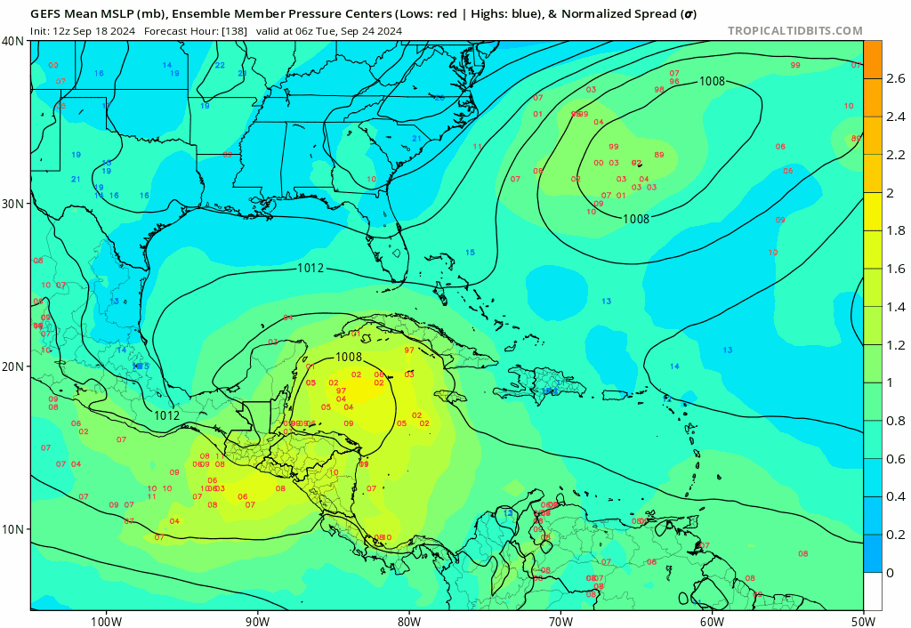
FWIW (not much at this point), 12z GEFS going to clobber FL. With amount of members, not necessarily strength.
0 likes
My Weather Station
https://www.wunderground.com/dashboard/pws/KFLPORTS603
https://www.wunderground.com/dashboard/pws/KFLPORTS603
-
SFLcane

- S2K Supporter
- Posts: 10281
- Age: 48
- Joined: Sat Jun 05, 2010 1:44 pm
- Location: Lake Worth Florida
Re: Area of low pressure to develop over the western Caribbean Sea
GEFS what in the heck are you doing? Stuck on the florida solution 
5 likes
-
Frank P
- S2K Supporter
- Posts: 2779
- Joined: Fri Aug 29, 2003 10:52 am
- Location: Biloxi Beach, Ms
- Contact:
Re: Area of low pressure to develop over the western Caribbean Sea
StPeteMike wrote:Ivanhater wrote:12z Canadian looks rough for Pensacola
Luckily it keeps it as a weak hurricane, but can’t say the GFS is best at intensity. The track is more concerning, that’s about two full days of water being pushed up the west coast.
12z Canadian shifted west to Mobile AL, 974mb is a Cat 2

0 likes
-
StPeteMike
- Category 2
- Posts: 657
- Joined: Thu Jun 07, 2018 11:26 pm
Re: Area of low pressure to develop over the western Caribbean Sea
Frank P wrote:StPeteMike wrote:Ivanhater wrote:12z Canadian looks rough for Pensacola
Luckily it keeps it as a weak hurricane, but can’t say the GFS is best at intensity. The track is more concerning, that’s about two full days of water being pushed up the west coast.
12z Canadian shifted west to Mobile AL, 974mb is a Cat 2
https://i.ibb.co/hH0R8GL/cmc.png
I meant GFS, not sure how Canadian looked like GFS to me.
1 likes
The above post is not official and should not be used as such. It is the opinion of the poster and may or may not be backed by sound meteorological data. It is not endorsed by any professional institution or storm2k.org. For official information, please refer to the NHC and NWS products.
-
DunedinDave
- Category 1
- Posts: 269
- Joined: Fri Aug 25, 2023 10:31 am
Re: Area of low pressure to develop over the western Caribbean Sea
I always look at the Hurricane Phoenix track as the most likely one to play out for a major storm to hit the TB area. If they’re gonna get it, it’s gonna come from that angle. Seems like some of the GFS ensembles want to copy that track here. Hope that doesn’t happen but it could form in that area with some of the ingredients for that right turn in place.
1 likes

Re: Area of low pressure to develop over the western Caribbean Sea
My best guess is that a vigorous but unorganized Low will race NNE across the East-Central GOM and across the Fl Apalachicola/Big Bend region.
This season's basin & global lack of instability coupled with upper level shear has me leaning towards Persistance regarding the possibility of cyclogenesis in the mid to long range. 2024 has taught me that Climatology and forecast ensemble models are simply less funtional toward predicting tropical cyclone development then they ordinarily would be in most years. Until I see an existing tropical disturbance with concentrated convection will I then consider a generally global model consensus as a reasonable outcome. Short of that I believe that any projection minus an extremely strong signal beyond 5 days, might as well be practically random.
This season's basin & global lack of instability coupled with upper level shear has me leaning towards Persistance regarding the possibility of cyclogenesis in the mid to long range. 2024 has taught me that Climatology and forecast ensemble models are simply less funtional toward predicting tropical cyclone development then they ordinarily would be in most years. Until I see an existing tropical disturbance with concentrated convection will I then consider a generally global model consensus as a reasonable outcome. Short of that I believe that any projection minus an extremely strong signal beyond 5 days, might as well be practically random.
3 likes
Andy D
(For official information, please refer to the NHC and NWS products.)
(For official information, please refer to the NHC and NWS products.)
Re: Area of low pressure to develop over the western Caribbean Sea
chaser1 wrote:My best guess is that a vigorous but unorganized Low will race NNE across the East-Central GOM and across the Fl Apalachicola/Big Bend region.
This season's basin & global lack of instability coupled with upper level shear has me leaning towards Persistance regarding the possibility of cyclogenesis in the mid to long range. 2024 has taught me that Climatology and forecast ensemble models are simply less funtional toward predicting tropical cyclone development then they ordinarily would be in most years. Until I see an existing tropical disturbance with concentrated convection will I then consider a generally global model consensus as a reasonable outcome. Short of that I believe that any projection minus an extremely strong signal beyond 5 days, might as well be practically random.
Keep in mind that this will likely form (if it does) from a gyre if not broader area of low pressure and not a single entity or intersection of a low pressure area and tropical wave or two low pressure centers like Francine. So if it races off NNE or staggers a bit off the Yucatan, it's going to come down to the upper pattern. Slower development and faster trough = no race NNE or a piece remaining back. Faster development and slower trough means probably farther west landfall (e.g. CMC). Slower development and slower trough = farther west. Faster consolidation and faster trough = NE Gulf.
2 likes
Who is online
Users browsing this forum: No registered users and 194 guests