Low pressure developing over the western Caribbean Sea (Is Invest 97L)
Moderator: S2k Moderators
Forum rules

The posts in this forum are NOT official forecasts and should not be used as such. They are just the opinion of the poster and may or may not be backed by sound meteorological data. They are NOT endorsed by any professional institution or STORM2K. For official information, please refer to products from the National Hurricane Center and National Weather Service.
-
Ivanhater

- Storm2k Moderator

- Posts: 11222
- Age: 39
- Joined: Fri Jul 01, 2005 8:25 am
- Location: Pensacola
Re: Area of low pressure to develop over the western Caribbean Sea
Wondering if we are gonna have an Opal-esque track . Who knows but GFS is coming into line with Icon and Euro
2 likes
Michael
-
WaveBreaking

- Category 2

- Posts: 727
- Joined: Sun Jun 30, 2024 11:33 am
- Location: US
Re: Area of low pressure to develop over the western Caribbean Sea
06Z GFS has it oddly merge with an EPAC model storm and start to bomb out in the SW Gulf at h225.
0 likes
I am NOT a professional meteorologist, so take all of my posts with a grain of salt. My opinions are mine and mine alone.
Re: Area of low pressure to develop over the western Caribbean Sea
6Z gfs caving to the euro!
0 likes
Re: Area of low pressure to develop over the western Caribbean Sea
wxman57 wrote:canes92 wrote:Why is the area highlighted when there's nothing there yet?
It's highlighted because we are expecting development to occur in that area. There is no disturbance to track, yet. We may not have an invest up until Monday, or Maybe Sunday evening.
Okay that makes sense. I thought it might be premature.
0 likes
-
eastcoastFL

- Category 5

- Posts: 3996
- Age: 44
- Joined: Thu Apr 12, 2007 12:29 pm
- Location: Palm City, FL
Re: Area of low pressure to develop over the western Caribbean Sea
At 246hrs it’s still just churning in the western gulf down to 949mb and growing large in size. Looked like we would get a break when it was over the Yucatán but it appears to be moving very slowly in the western gulf.
0 likes
Personal Forecast Disclaimer:
The posts in this forum are NOT official forecast and should not be used as such. They are just the opinion of the poster and may or may not be backed by sound meteorological data. They are NOT endorsed by any professional institution or storm2k.org. For official information, please refer to the NHC and NWS products.
The posts in this forum are NOT official forecast and should not be used as such. They are just the opinion of the poster and may or may not be backed by sound meteorological data. They are NOT endorsed by any professional institution or storm2k.org. For official information, please refer to the NHC and NWS products.

Re: Area of low pressure to develop over the western Caribbean Sea
GFS trying to make the second coming of Opal but much larger based on 06z track, out to Sep 29
0 likes
The above post is not official and should not be used as such. It is the opinion of the poster and may or may not be backed by sound meteorological data. It is not endorsed by any professional institution or storm2k.org. For official information, please refer to the NHC and NWS products.

Re: Area of low pressure to develop over the western Caribbean Sea
6z hits the brakes, deepens, and turns northeast:

Sent from my iPad using Tapatalk
Sent from my iPad using Tapatalk
1 likes

Re: Area of low pressure to develop over the western Caribbean Sea
06z GFS, bombing out in the GOM at +258hrs, 946 mbar (note: the other system in the MDR also seems to go wild, another MH).

2 likes
-
Ivanhater
- Storm2k Moderator
- Posts: 11222
- Age: 39
- Joined: Fri Jul 01, 2005 8:25 am
- Location: Pensacola
Re: Area of low pressure to develop over the western Caribbean Sea
Ivanhater wrote:Wondering if we are gonna have an Opal-esque track . Who knows but GFS is coming into line with Icon and Euro
There it goes
1 likes
Michael
-
eastcoastFL
- Category 5
- Posts: 3996
- Age: 44
- Joined: Thu Apr 12, 2007 12:29 pm
- Location: Palm City, FL
Re: Area of low pressure to develop over the western Caribbean Sea
Ivanhater wrote:Ivanhater wrote:Wondering if we are gonna have an Opal-esque track . Who knows but GFS is coming into line with Icon and Euro
There it goes
Not loving this set up. Just the enormous size of this could have potentially devastating storm surge effects across large portions of the gulf.
2 likes
Personal Forecast Disclaimer:
The posts in this forum are NOT official forecast and should not be used as such. They are just the opinion of the poster and may or may not be backed by sound meteorological data. They are NOT endorsed by any professional institution or storm2k.org. For official information, please refer to the NHC and NWS products.
The posts in this forum are NOT official forecast and should not be used as such. They are just the opinion of the poster and may or may not be backed by sound meteorological data. They are NOT endorsed by any professional institution or storm2k.org. For official information, please refer to the NHC and NWS products.
-
eastcoastFL
- Category 5
- Posts: 3996
- Age: 44
- Joined: Thu Apr 12, 2007 12:29 pm
- Location: Palm City, FL
Re: Area of low pressure to develop over the western Caribbean Sea
Looks to be slightly weakening as it heads towards the panhandle again
0 likes
Personal Forecast Disclaimer:
The posts in this forum are NOT official forecast and should not be used as such. They are just the opinion of the poster and may or may not be backed by sound meteorological data. They are NOT endorsed by any professional institution or storm2k.org. For official information, please refer to the NHC and NWS products.
The posts in this forum are NOT official forecast and should not be used as such. They are just the opinion of the poster and may or may not be backed by sound meteorological data. They are NOT endorsed by any professional institution or storm2k.org. For official information, please refer to the NHC and NWS products.
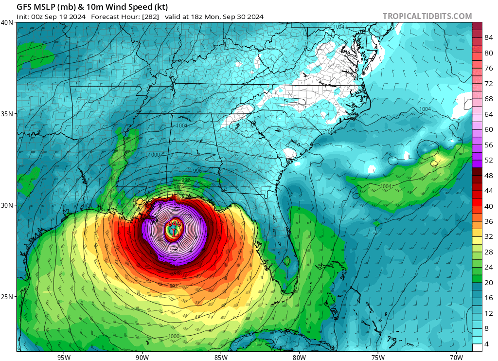
Re: Area of low pressure to develop over the western Caribbean Sea
+ 282hr

Sent from my iPad using Tapatalk
Sent from my iPad using Tapatalk
1 likes
-
ThunderForce

- Tropical Storm

- Posts: 208
- Age: 26
- Joined: Tue Sep 27, 2022 6:20 pm
- Location: Calhoun County, Florida
Re: Area of low pressure to develop over the western Caribbean Sea
Bizarrely, despite the track shift between 00z and 06z causing it to go to the Yucatan, 06z ends up in basically the same location as 00z GFS, at 18z Monday September 30th. Same exact pressure too.
4 likes
Please refer to the NWS, NHC, SPC or a professional meteorologist for information and decision making during storms.
Re: Area of low pressure to develop over the western Caribbean Sea
06z GFS, landfall just south of Panama City, +288 hrs. 957 mb after peaking at 945 mb.

0 likes
Re: Area of low pressure to develop over the western Caribbean Sea
Watching with keen interest from Tallahassee:

Sent from my iPad using Tapatalk
Sent from my iPad using Tapatalk
3 likes
Re: Area of low pressure to develop over the western Caribbean Sea
Apalachicola hit

Sent from my iPad using Tapatalk
Sent from my iPad using Tapatalk
0 likes
-
Frank P
- S2K Supporter

- Posts: 2779
- Joined: Fri Aug 29, 2003 10:52 am
- Location: Biloxi Beach, Ms
- Contact:
Re: Area of low pressure to develop over the western Caribbean Sea
GFS 06z loop in the GOM. landfall shifted east towards PC and surge on Mexico City would be catastrophic if it were to verify, but this will change too down the road, they always do this far out.

0 likes
-
Stormlover70
- Tropical Storm
- Posts: 194
- Age: 56
- Joined: Fri Jun 21, 2024 5:31 am
- Location: New port richey
Re: Area of low pressure to develop over the western Caribbean Sea
Too close for comfort here on the west coast north of Tampa. WE have dodged many bullets. Hopefully we dodge this one!
1 likes
-
MHC Tracking
- Tropical Storm
- Posts: 203
- Joined: Mon Mar 15, 2021 10:05 am
Re: Area of low pressure to develop over the western Caribbean Sea
WaveBreaking wrote:06Z GFS has it oddly merge with an EPAC model storm and start to bomb out in the SW Gulf at h225.
In reality, would be shocked if the two interact beyond causing each other outflow restriction.
There was a similar situation modeled in 2021 with Nora and Ida. In the end, the GFS turned out to be significantly overblowing Nora, as so often occurs with its mid-range depictions of EPAC storms.
2 likes
Who is online
Users browsing this forum: LadyBug72 and 178 guests