Low pressure developing over the western Caribbean Sea (Is Invest 97L)
Moderator: S2k Moderators
Forum rules

The posts in this forum are NOT official forecasts and should not be used as such. They are just the opinion of the poster and may or may not be backed by sound meteorological data. They are NOT endorsed by any professional institution or STORM2K. For official information, please refer to products from the National Hurricane Center and National Weather Service.

Re: Area of low pressure to develop over the western Caribbean Sea
12Z GFS could not have possibly ended better! Storm #2 maintains due west motion sparing Miami, just to ravage poor Cuba to the south. But then at 354 hr. the storm slips SW just south of W. Cuba and re-intensifies to 964 mb with all ridging collapsing and a new trough fast dropping out of the Midwest hanging south to the Louisiana coast, and at 372 hr's the strengthening small hurricane appears poised once again to aim for S. Florida.
3 likes
Andy D
(For official information, please refer to the NHC and NWS products.)
(For official information, please refer to the NHC and NWS products.)
-
cheezyWXguy

- Category 5

- Posts: 6282
- Joined: Mon Feb 13, 2006 12:29 am
- Location: Dallas, TX
Re: Area of low pressure to develop over the western Caribbean Sea
3090 wrote:Imagine the NHC posting a cone right now? It would be from Tampa over to Texas coast. Just saying.
That would be the case if the cone contained actual track uncertainty, but instead it shows statistical track uncertainty based on historical margin of error.
1 likes
-
StPeteMike

- Category 2

- Posts: 656
- Joined: Thu Jun 07, 2018 11:26 pm
Re: Area of low pressure to develop over the western Caribbean Sea
chaser1 wrote:12Z GFS could not have possibly ended better! Storm #2 maintains due west motion sparing Miami, just to ravage poor Cuba to the south. But then at 354 hr. the storm slips SW just south of W. Cuba and re-intensifies to 964 mb with all ridging collapsing and a new trough fast dropping out of the Midwest hanging south to the Louisiana coast, and at 372 hr's the strengthening small hurricane appears poised once again to aim for S. Florida.
GFS got confused and thought this was 18z with the Happy Hour run.
0 likes
The above post is not official and should not be used as such. It is the opinion of the poster and may or may not be backed by sound meteorological data. It is not endorsed by any professional institution or storm2k.org. For official information, please refer to the NHC and NWS products.
-
DunedinDave
- Category 1

- Posts: 269
- Joined: Fri Aug 25, 2023 10:31 am
Re: Area of low pressure to develop over the western Caribbean Sea
GFS is on crack. All they’re doing is copying Hurricane Phoenix’s track and plotting the points. This stuff ain’t funny dude.
0 likes

Re: Area of low pressure to develop over the western Caribbean Sea
Canadian 976mb landfall south of lake Charles but on a northward heading. There is almost no eastern component and in fact even after landfall it goes north and hooks a little left into Kansas. That’s a really odd track for late September.
https://www.tropicaltidbits.com/analysi ... 912&fh=210
The difference with the CMC vs the GFS is that the Canadian builds a ridge between the east coast cut off and a low center around Oklahoma.
https://www.tropicaltidbits.com/analysi ... 912&fh=198
https://www.tropicaltidbits.com/analysi ... 912&fh=210
The difference with the CMC vs the GFS is that the Canadian builds a ridge between the east coast cut off and a low center around Oklahoma.
https://www.tropicaltidbits.com/analysi ... 912&fh=198
Last edited by Steve on Thu Sep 19, 2024 12:28 pm, edited 1 time in total.
0 likes
Re: Area of low pressure to develop over the western Caribbean Sea
And there you have it. Cliff hanger LOL. At 380 hr's, the hurricane is over the extreme Western tip of Cuba at 960 mb drifting NE. "HELLO Key West & Cape Coral, I see you".
That GFS run was more fun then expected. Think I need a cold shower after that 12Z fantasy.
That GFS run was more fun then expected. Think I need a cold shower after that 12Z fantasy.
3 likes
Andy D
(For official information, please refer to the NHC and NWS products.)
(For official information, please refer to the NHC and NWS products.)
Re: Area of low pressure to develop over the western Caribbean Sea
cheezyWXguy wrote:3090 wrote:Imagine the NHC posting a cone right now? It would be from Tampa over to Texas coast. Just saying.
That would be the case if the cone contained actual track uncertainty, but instead it shows statistical track uncertainty based on historical margin of error.
I was not being serious obviously. The NHC is never going to issue a forecast track without a storm. I was simply trying to convey a message of wide uncertainty. The GFS tends to over amplify trofs and will have an east bias. The EURO has a left bias and under estimates trof axis. So as typical this early we have nothing of certainty.
0 likes
-
DunedinDave
- Category 1
- Posts: 269
- Joined: Fri Aug 25, 2023 10:31 am
Re: Area of low pressure to develop over the western Caribbean Sea
psyclone wrote:I don't know where it's going other than to say it won't be Tampa bay. We don't mess with these. You can tell us a cat 5 is coming and people will shrug their shoulders and move on. I distinctly recall people grumbling on the lead up to Ian about how they never come here...and they were right...again. tampa bay will not prepare for a hurricane again until they are first crushed which hasn't happened in over a century. The professional class has given us too many false alarms and we are totally done. We just waitin' on a cold front...
The good news is it’s got a cat 5 hitting us 10 days out. Every major Hurricane I’ve ever known to go into the Gulf has at least had a model that’s slammed Tampa Bay. Then when we get to within 72 hours they go south or north. So I’m glad we’re getting these runs out of the way now. Cause the big one that hits us is going to be one that no model has coming our way and will at the last second like Ian did to Fort Myers.
0 likes

Re: Area of low pressure to develop over the western Caribbean Sea
ConvergenceZone wrote:toad strangler wrote:I don't think there is one cloud in the region yet that will be associated with the spin up. Thus, it's "pin the tail on the donkey" every model cycle.
haha, maybe now we can take guesses on when the first cloud will show up. I'm thinking Sunday
Yeah, current model consensus is the first deep convection popping up on Sunday night.
2 likes
Kendall -> SLO -> PBC
Memorable Storms: Katrina (for its Florida landfall...) Wilma Matthew Irma
Memorable Storms: Katrina (for its Florida landfall...) Wilma Matthew Irma
Re: Area of low pressure to develop over the western Caribbean Sea
Steve wrote:Canadian 976mb landfall south of lake Charles but on a northward heading. There is almost no eastern component and in fact even after landfall it goes north and hooks a little left into Kansas. That’s a really odd track for late September.
https://www.tropicaltidbits.com/analysi ... 912&fh=210
The difference with the CMC vs the GFS is that the Canadian builds a ridge between the east coast cut off and a low center around Oklahoma.
https://www.tropicaltidbits.com/analysi ... 912&fh=198
Meanwhile, it really seems like the GFS is overplaying the depth of the east CONUS trough at the beginning of the cycle, and then the depth of the W. Atlantic westward ridging at the end of that cycle.
1 likes
Andy D
(For official information, please refer to the NHC and NWS products.)
(For official information, please refer to the NHC and NWS products.)
Re: Area of low pressure to develop over the western Caribbean Sea
DunedinDave wrote:GFS is on crack. All they’re doing is copying Hurricane Phoenix’s track and plotting the points. This stuff ain’t funny dude.
It’s kinda funny. You gotta laugh at these fantasy runs.
0 likes


Re: Area of low pressure to develop over the western Caribbean Sea
ConvergenceZone wrote:toad strangler wrote:I don't think there is one cloud in the region yet that will be associated with the spin up. Thus, it's "pin the tail on the donkey" every model cycle.
haha, maybe now we can take guesses on when the first cloud will show up. I'm thinking Sunday
Around 15z Saturday.
0 likes
-
SFLcane

- S2K Supporter

- Posts: 10281
- Age: 48
- Joined: Sat Jun 05, 2010 1:44 pm
- Location: Lake Worth Florida
Re: Area of low pressure to develop over the western Caribbean Sea
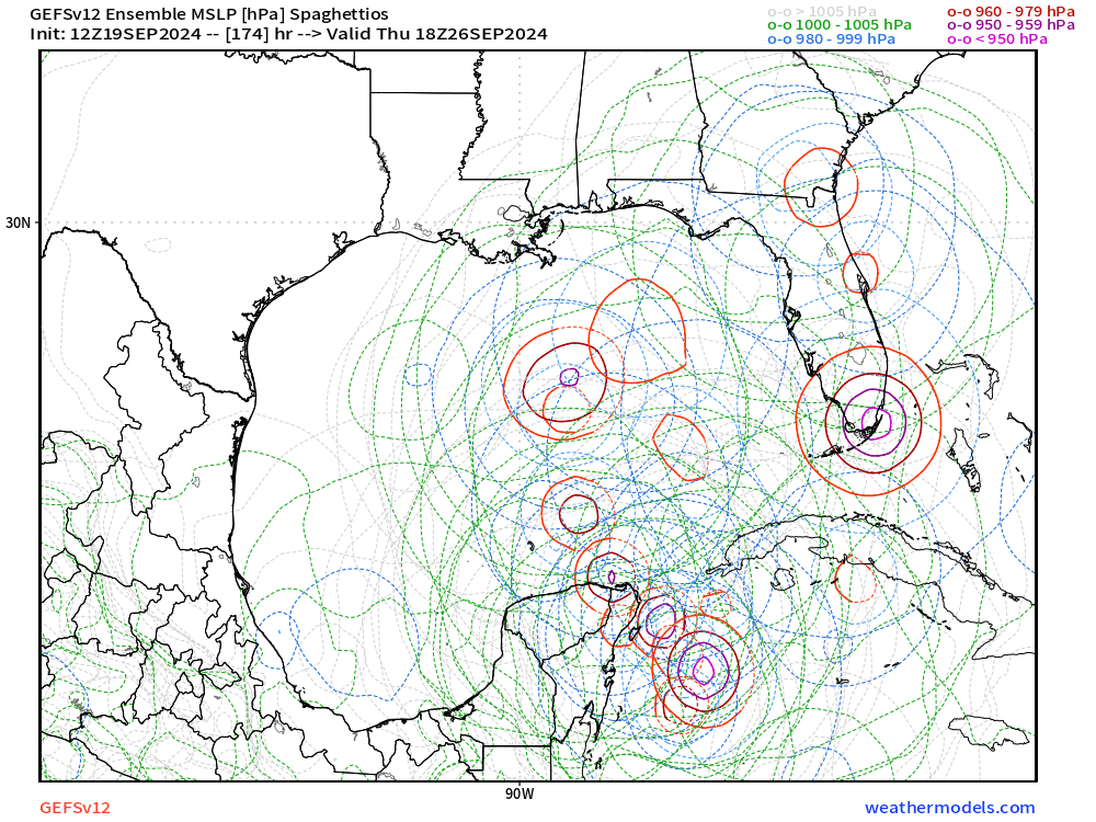
SouthFLTropics wrote:FWIW... GEFS 12z Ensembles still like the middle to eastern GOM. Not seeing much get past New Orleans longitude through 204 hours.
Destruction for FL lol..
1 likes
-
DunedinDave
- Category 1
- Posts: 269
- Joined: Fri Aug 25, 2023 10:31 am
Re: Area of low pressure to develop over the western Caribbean Sea
Fancy1002 wrote:DunedinDave wrote:GFS is on crack. All they’re doing is copying Hurricane Phoenix’s track and plotting the points. This stuff ain’t funny dude.
It’s kinda funny. You gotta laugh at these fantasy runs.
Yeah but there’s gonna come a day (hopefully after I’ve left this earth) where this kind of run will be a reality.
0 likes
-
AutoPenalti
- Category 5
- Posts: 4091
- Age: 29
- Joined: Mon Aug 17, 2015 4:16 pm
- Location: Ft. Lauderdale, Florida
Re: Area of low pressure to develop over the western Caribbean Sea
WaveBreaking wrote:And now the MDR hurricane is bombing out in the WCAR I can’t with this run
https://i.imgur.com/P3ePejO.gif
What the hell is that...
2 likes
The posts in this forum are NOT official forecasts and should not be used as such. They are just the opinion of the poster and may or may not be backed by sound meteorological data. They are NOT endorsed by any professional institution or STORM2K. For official information, please refer to products from the NHC and NWS.
Model Runs Cheat Sheet:
GFS (5:30 AM/PM, 11:30 AM/PM)
HWRF, GFDL, UKMET, NAVGEM (6:30-8:00 AM/PM, 12:30-2:00 AM/PM)
ECMWF (1:45 AM/PM)
TCVN is a weighted averaged

Re: Area of low pressure to develop over the western Caribbean Sea
chaser1 wrote:12 GFS is out to 126 hr's and i'm seeing shades of the goal posts moving back a bit. The EPAC low and W Caribbean Low seems to be part of the overall Gyre thus delaying development for the larger overall feature. Also as a sidenote, forget about ex-Gordon or the E. MDR wave coming off Africa. Seems that GFS is just not feeling them up to 126 hr's.
Narrator: The Eastern MDR wave survived until 384 hrs while threatening South Florida twice.
1 likes
TC naming lists: retirements and intensity
Most aggressive Advisory #1's in North Atlantic (cr. kevin for starting the list)
Most aggressive Advisory #1's in North Atlantic (cr. kevin for starting the list)
-
StPeteMike
- Category 2
- Posts: 656
- Joined: Thu Jun 07, 2018 11:26 pm
Re: Area of low pressure to develop over the western Caribbean Sea
chaser1 wrote:Steve wrote:Canadian 976mb landfall south of lake Charles but on a northward heading. There is almost no eastern component and in fact even after landfall it goes north and hooks a little left into Kansas. That’s a really odd track for late September.
https://www.tropicaltidbits.com/analysi ... 912&fh=210
The difference with the CMC vs the GFS is that the Canadian builds a ridge between the east coast cut off and a low center around Oklahoma.
https://www.tropicaltidbits.com/analysi ... 912&fh=198
Meanwhile, it really seems like the GFS is overplaying the depth of the east CONUS trough at the beginning of the cycle, and then the depth of the W. Atlantic westward ridging at the end of that cycle.
I have seen many years of overdoing and underdoing (it’s a word! haha) of potential troughs, even a day or so out.
But I’ll say that the forecasted ridge is being overdone in this instance. The trough is still expected to be close to the region Friday/Saturday according to the local temperature/precipitation chances here. I don’t see a ridge staying over the southeast as the Canadian is modeling.
2 likes
The above post is not official and should not be used as such. It is the opinion of the poster and may or may not be backed by sound meteorological data. It is not endorsed by any professional institution or storm2k.org. For official information, please refer to the NHC and NWS products.
-
TomballEd
- Category 5
- Posts: 1293
- Age: 62
- Joined: Wed Aug 16, 2023 4:52 pm
- Location: Spring/Klein area, not Tomball
Re: Area of low pressure to develop over the western Caribbean Sea
The Tampa Bay thing, 50 years ago when I was a student in Catholic school I checked out a book from the school library about hurricanes written by a man from Tampa who had shot down a Japanese plane at Pearl Harbor. Anyway, he said Tampa seems to have a protective force field, he recalled several forecast misses and sudden weakening. But 50 years ago people in Tampa thought there was a magic field. Something to do with Native Americans, IIRC.
Of course, a big hurricane will hit Tampa Bay, but the frequency seems low.
I got interested in hurricanes first from my parents' stories of 1938, and then Hurricane Belle in 1976. My Dad wouldn't let me go outside for the eye.
Will the force field hold again?
Of course, a big hurricane will hit Tampa Bay, but the frequency seems low.
I got interested in hurricanes first from my parents' stories of 1938, and then Hurricane Belle in 1976. My Dad wouldn't let me go outside for the eye.
Will the force field hold again?
2 likes
-
cycloneye

- Admin

- Posts: 149511
- Age: 69
- Joined: Thu Oct 10, 2002 10:54 am
- Location: San Juan, Puerto Rico
Re: Area of low pressure to develop over the western Caribbean Sea
2 PM:
Northwestern Caribbean Sea and Southeastern Gulf of Mexico:
A broad area of low pressure could form by early next week over the
northwestern Caribbean Sea. Thereafter, gradual development of this
system is possible, and a tropical depression could form as the
system moves slowly to the north or northwest over the northwestern
Caribbean Sea and into the southern Gulf of Mexico through the
middle part of next week.
* Formation chance through 48 hours...low...near 0 percent.
* Formation chance through 7 days...medium...40 percent.
1 likes
Visit the Caribbean-Central America Weather Thread where you can find at first post web cams,radars
and observations from Caribbean basin members Click Here
and observations from Caribbean basin members Click Here
Re: Area of low pressure to develop over the western Caribbean Sea
"Alex, I think I'll go with Alabama for $500"
Daily double!
"Um, who are the GFS 18Z Happy Hour model run victims this time around?"
Daily double!
"Um, who are the GFS 18Z Happy Hour model run victims this time around?"
2 likes
Andy D
(For official information, please refer to the NHC and NWS products.)
(For official information, please refer to the NHC and NWS products.)
Who is online
Users browsing this forum: ouragans and 465 guests