Low pressure developing over the western Caribbean Sea (Is Invest 97L)
Moderator: S2k Moderators
Forum rules

The posts in this forum are NOT official forecasts and should not be used as such. They are just the opinion of the poster and may or may not be backed by sound meteorological data. They are NOT endorsed by any professional institution or STORM2K. For official information, please refer to products from the National Hurricane Center and National Weather Service.
-
Stratton23
- Category 5

- Posts: 3563
- Joined: Fri Jul 21, 2023 10:59 pm
- Location: Katy, Tx
Re: Area of low pressure to develop over the western Caribbean Sea
The GFS is a head scratcher
1 likes
-
Category5Kaiju

- Category 5
- Posts: 4335
- Joined: Thu Dec 24, 2020 12:45 pm
- Location: Seattle during the summer, Phoenix during the winter
Re: Area of low pressure to develop over the western Caribbean Sea
So over the course of a single GFS model cycle, we went from Tampa being wiped off the map by a Category 4/5 hurricane to a weak storm hitting the general area.
It's fun to look at GFS operational runs, but it's also important to keep in mind that at least at this particular stage of this possible storm's life, these runs are extremely sensitive and can yield a radically different outcome every time. Ensembles probably paint a better picture of the possibilities, imho.
It's fun to look at GFS operational runs, but it's also important to keep in mind that at least at this particular stage of this possible storm's life, these runs are extremely sensitive and can yield a radically different outcome every time. Ensembles probably paint a better picture of the possibilities, imho.
3 likes
Unless explicitly stated, all information in my posts is based on my own opinions and observations. Tropical storms and hurricanes can be extremely dangerous. Refer to an accredited weather research agency or meteorologist if you need to make serious decisions regarding an approaching storm.
-
Hypercane_Kyle

- Category 5
- Posts: 3465
- Joined: Sat Mar 07, 2015 7:58 pm
- Location: Cape Canaveral, FL
Re: Area of low pressure to develop over the western Caribbean Sea
The amount of run-to-run variation is incredible, even for a system this far out for genesis.
0 likes
My posts are my own personal opinion, defer to the National Hurricane Center (NHC) and other NOAA products for decision making during hurricane season.
Re: Area of low pressure to develop over the western Caribbean Sea
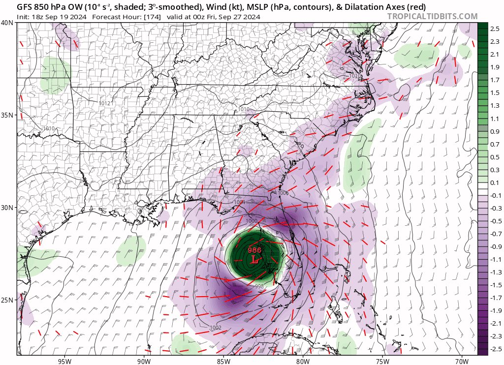
FWIW…18Z GFS.
POOF! A mess of rain and just a cluster really of not much. So it is the 18Z of which many poo poo on.
And in the SC GOM.
POOF! A mess of rain and just a cluster really of not much. So it is the 18Z of which many poo poo on.
And in the SC GOM.
0 likes

Re: Area of low pressure to develop over the western Caribbean Sea
3090 wrote:FWIW…18Z GFS.
POOF! A mess of rain and just a cluster really of not much. So it is the 18Z of which many poo poo on.
I thought you said just 40 minutes ago that models were clearly trending west? And yet 18z GFS is the furthest east that it has been for almost 2 days
1 likes
TC naming lists: retirements and intensity
Most aggressive Advisory #1's in North Atlantic (cr. kevin for starting the list)
Most aggressive Advisory #1's in North Atlantic (cr. kevin for starting the list)
-
Stratton23
- Category 5
- Posts: 3563
- Joined: Fri Jul 21, 2023 10:59 pm
- Location: Katy, Tx
Re: Area of low pressure to develop over the western Caribbean Sea
Im not sure the GFS is really seeing how this is going to play out, part in due to its biacy with the EPAC and overdoing systems, has a rapidly intensifying MI in the EPAC associated with the CAG, im not buying that
Last edited by Stratton23 on Thu Sep 19, 2024 5:35 pm, edited 1 time in total.
0 likes
-
SFLcane

- S2K Supporter

- Posts: 10281
- Age: 48
- Joined: Sat Jun 05, 2010 1:44 pm
- Location: Lake Worth Florida
Re: Area of low pressure to develop over the western Caribbean Sea
HP protecting FL gone on the gfs.. hmm
Last edited by SFLcane on Thu Sep 19, 2024 5:36 pm, edited 1 time in total.
0 likes
Re: Area of low pressure to develop over the western Caribbean Sea
Teban54 wrote:3090 wrote:FWIW…18Z GFS.
POOF! A mess of rain and just a cluster really of not much. So it is the 18Z of which many poo poo on.
I thought you said just 40 minutes ago that models were clearly trending west? And yet 18z GFS is the furthest east that it has been for almost 2 days
It is the 18Z that numerous folks in here discredit. So yeah the 18Z GFS is an outlier of a mess. And the GFS STILL over does trofs. So as always stay tuned. Long way to go there.
Last edited by 3090 on Thu Sep 19, 2024 5:37 pm, edited 1 time in total.
2 likes

Re: Area of low pressure to develop over the western Caribbean Sea
Environment is very similar this run. The cause for the major shift is a much stronger trough that comes dipping down in the day 5-7 range. Previous run this trough was more shallow and left the storm slowly crawling over the Gulf instead. It’s a matter of time over water.
4 likes
Kendall -> SLO -> PBC
Memorable Storms: Katrina (for its Florida landfall...) Wilma Matthew Irma
Memorable Storms: Katrina (for its Florida landfall...) Wilma Matthew Irma
Re: Area of low pressure to develop over the western Caribbean Sea
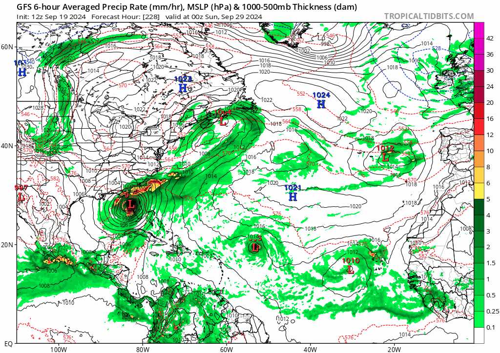
18z gfs ts/cat 1 landfall tampa then cat 2 landfall in new england.
2 likes
Re: Area of low pressure to develop over the western Caribbean Sea
Ubuntwo wrote:Environment is very similar this run. The cause for the major shift is a much stronger trough that comes dipping down in the day 5-7 range. Previous run this trough was more shallow and left the storm slowly crawling over the Gulf instead. It’s a matter of time over water.
I dont give a lot of credence to the GFS when it comes to troughs picking up storms. Especially to storms that have not yet even formed. BUT we shall see. Who knows.
0 likes
-
Stratton23
- Category 5
- Posts: 3563
- Joined: Fri Jul 21, 2023 10:59 pm
- Location: Katy, Tx
Re: Area of low pressure to develop over the western Caribbean Sea
As of right now, the GFS is a clear outlier in terms of an eastern gulf solution , we shall see what the overnight runs bring
1 likes

Re: Area of low pressure to develop over the western Caribbean Sea
18z GEFS still pretty active in the Caribbean.
0 likes
Re: Area of low pressure to develop over the western Caribbean Sea
Steve wrote:hipshot wrote:Steve wrote:Interestingly many of the MJO models are forecasting a move toward 8/1 next week. We haven’t been in super favorable territory since Debby and Ernesto. It’s likely why the Atlantic underperformed hyper seasonal forecasts. The Australian model doesn’t agree but it won’t update until tomorrow or Saturday. We could see a few intense systems if we get to 8/1/2/3 but that would only last until the second week of October unless it ducks back into the circle and re-emerges a couple days later.
I think you meant 10/1/2/3...correct?
No. MJO Phases go 1 through 8. It correlates with eastward moving “disturbance” moving across from the Indian Ocean or WPAC. I’m not on laptop today so I can’t send you a bunch of links. But depending on the phase we are in at a given time (or within the circle) telegraphs tropical weather and where to look for it, if at all, in the tropical Atlantic. Phases 2 and 3 are hyper for the Gulf. 8 and 1 are generally favorable as well. Fwiw it also telegraphs weather patterns in the winter.
Here is the link to the Climate Prediction Center and the models they use and an explanation of what each model represents. If you mouse over them on laptop or desktop those models will come up. Otherwise click and backspace.
https://www.cpc.ncep.noaa.gov/products/ ... r_wh.shtml
Opps, I didn't pay attention to the MJO you mentioned, I've been out in the sun to long today.
1 likes
-
Spacecoast

- Category 2

- Posts: 773
- Joined: Thu Aug 31, 2017 2:03 pm
Re: Area of low pressure to develop over the western Caribbean Sea
18z GFS Express...
Gets yanked from W of Tampa to OBX in 24 hours. That's one strong trough.
Gets yanked from W of Tampa to OBX in 24 hours. That's one strong trough.
1 likes
-
ConvergenceZone
.gif)
- Category 5
- Posts: 5241
- Joined: Fri Jul 29, 2005 1:40 am
- Location: Northern California
Re: Area of low pressure to develop over the western Caribbean Sea
3090 wrote:FWIW…18Z GFS.
POOF! A mess of rain and just a cluster really of not much. So it is the 18Z of which many poo poo on.
And in the SC GOM.
I knew GFS was on crack when I saw a cat 5 hitting Tampa. The new model run seems much more realistic.
0 likes
-
cheezyWXguy

- Category 5
- Posts: 6282
- Joined: Mon Feb 13, 2006 12:29 am
- Location: Dallas, TX
Re: Area of low pressure to develop over the western Caribbean Sea
3090 wrote:Teban54 wrote:3090 wrote:FWIW…18Z GFS.
POOF! A mess of rain and just a cluster really of not much. So it is the 18Z of which many poo poo on.
I thought you said just 40 minutes ago that models were clearly trending west? And yet 18z GFS is the furthest east that it has been for almost 2 days
It is the 18Z that numerous folks in here discredit. So yeah the 18Z GFS is an outlier of a mess. And the GFS STILL over does trofs. So as always stay tuned. Long way to go there.
I am desperate for this talking point to die. The 18z is not worse than the other runs. Like, 15-20 years ago, it used to be that the 6z and 18z models were not fed new initialization data (or at least, significantly less) compared to their previous 0z/12z runs. This is not the case anymore and hasn’t been for a while.
4 likes
Re: Area of low pressure to develop over the western Caribbean Sea
2-run trend, from a Tampa landfall to a Maine landfall:
(Both possibilities still have support from earlier GEFS runs, so I don't think either can be discounted.)
(Both possibilities still have support from earlier GEFS runs, so I don't think either can be discounted.)
1 likes
TC naming lists: retirements and intensity
Most aggressive Advisory #1's in North Atlantic (cr. kevin for starting the list)
Most aggressive Advisory #1's in North Atlantic (cr. kevin for starting the list)

Re: Area of low pressure to develop over the western Caribbean Sea
ConvergenceZone wrote:3090 wrote:FWIW…18Z GFS.
POOF! A mess of rain and just a cluster really of not much. So it is the 18Z of which many poo poo on.
And in the SC GOM.
I knew GFS was on crack when I saw a cat 5 hitting Tampa. The new model run seems much more realistic.
Perhaps for the GFS.
Last edited by Steve on Thu Sep 19, 2024 5:49 pm, edited 1 time in total.
0 likes
Who is online
Users browsing this forum: Google Adsense [Bot] and 215 guests