Low pressure developing over the western Caribbean Sea (Is Invest 97L)
Moderator: S2k Moderators
Forum rules

The posts in this forum are NOT official forecasts and should not be used as such. They are just the opinion of the poster and may or may not be backed by sound meteorological data. They are NOT endorsed by any professional institution or STORM2K. For official information, please refer to products from the National Hurricane Center and National Weather Service.

Re: Area of low pressure to develop over the western Caribbean Sea
12Z GFS the ridging is a little weaker with the 1014 mb isobar retreating NE into Georgia. Storm is dropping into the 970's south of Mobile bay at 180 hours.
1 likes
-
DunedinDave
- Category 1

- Posts: 269
- Joined: Fri Aug 25, 2023 10:31 am
Re: Area of low pressure to develop over the western Caribbean Sea
12z GFS developing this south of Isle of Youth. Way more east. But moves it more NNW into New Orleans. Definitely a more unique track compared to what we’ve seen.
1 likes
-
Frank P
- S2K Supporter

- Posts: 2779
- Joined: Fri Aug 29, 2003 10:52 am
- Location: Biloxi Beach, Ms
- Contact:
Re: Area of low pressure to develop over the western Caribbean Sea
The sat IR loop I posted earlier today in the NW Caribbean has seen its convection fade during the past several hours and now the area off to the SW of that area is looking more interesting with its building convection.

2 likes
-
AutoPenalti
- Category 5

- Posts: 4091
- Age: 29
- Joined: Mon Aug 17, 2015 4:16 pm
- Location: Ft. Lauderdale, Florida
Re: Area of low pressure to develop over the western Caribbean Sea
GFS continues to push back the trough timing and allows the ridge to build over Florida.
0 likes
The posts in this forum are NOT official forecasts and should not be used as such. They are just the opinion of the poster and may or may not be backed by sound meteorological data. They are NOT endorsed by any professional institution or STORM2K. For official information, please refer to products from the NHC and NWS.
Model Runs Cheat Sheet:
GFS (5:30 AM/PM, 11:30 AM/PM)
HWRF, GFDL, UKMET, NAVGEM (6:30-8:00 AM/PM, 12:30-2:00 AM/PM)
ECMWF (1:45 AM/PM)
TCVN is a weighted averaged
-
Ivanhater

- Storm2k Moderator

- Posts: 11221
- Age: 39
- Joined: Fri Jul 01, 2005 8:25 am
- Location: Pensacola
Re: Area of low pressure to develop over the western Caribbean Sea
12z GFS into Mississippi coast
12z Canadian into Central Louisiana
12z Icon Destin.
I think we are starting to see some consolidation onto northern gulf coast
12z Canadian into Central Louisiana
12z Icon Destin.
I think we are starting to see some consolidation onto northern gulf coast
1 likes
Michael
-
DunedinDave
- Category 1
- Posts: 269
- Joined: Fri Aug 25, 2023 10:31 am
Re: Area of low pressure to develop over the western Caribbean Sea
So did the TB area dodge another bullet? Crazy how we keep getting lucky.
2 likes
-
LadyBug72

- Tropical Storm

- Posts: 121
- Joined: Mon Jun 01, 2020 3:39 pm
- Location: about 20 miles from Galveston, Tx
Re: Area of low pressure to develop over the western Caribbean Sea
DunedinDave wrote:12z GFS developing this south of Isle of Youth. Way more east. But moves it more NNW into New Orleans. Definitely a more unique track compared to what we’ve seen.
Is it into NOLA or the MS Coast? It is very hard to see.
0 likes
Formerly known as the user: Nikki
Alicia 83, Allison 01, Rita 05, Ike 08, Harvey 17, Nicholas 21, Coastal Texas Derecho 24, Beryl 24
Alicia 83, Allison 01, Rita 05, Ike 08, Harvey 17, Nicholas 21, Coastal Texas Derecho 24, Beryl 24
-
Pipelines182
- Tropical Storm
- Posts: 159
- Joined: Tue Jul 02, 2024 8:46 am
Re: Area of low pressure to develop over the western Caribbean Sea
DunedinDave wrote:So did the TB area dodge another bullet? Crazy how we keep getting lucky.
way too early to assume anyone dodged anything yet
0 likes
-
cheezyWXguy

- Category 5
- Posts: 6282
- Joined: Mon Feb 13, 2006 12:29 am
- Location: Dallas, TX
Re: Area of low pressure to develop over the western Caribbean Sea
I’ve been watching the last several runs of these models for key details, and here’s what I’ve gathered:
- from run to run, there’s a general consistency with when the gyre takes shape, but there is notable inconsistency in where/when/how the resultant TC forms. Sometimes from an area of vorticity on the periphery of the gyre, sometimes from the gyre itself.
- earlier, stronger development is inversely related to the strength of whatever epac tc forms in the same time period. I’m not sure how legitimate the epac tc is. I am also not sure why the epac tc exerts influence on the Atlantic tc, but seemingly not vice-versa. Maybe someone can answer this
2 likes
-
ConvergenceZone
.gif)
- Category 5
- Posts: 5241
- Joined: Fri Jul 29, 2005 1:40 am
- Location: Northern California
Re: Area of low pressure to develop over the western Caribbean Sea
Hypercane_Kyle wrote:No longer much model support for anything particularly intense. Looks weak and strung out.
I thought the latest GFS model was showing hurricane strength still? Or maybe there's been another one since then that I missed.
Last edited by ConvergenceZone on Fri Sep 20, 2024 11:48 am, edited 1 time in total.
1 likes
-
Frank P
- S2K Supporter
- Posts: 2779
- Joined: Fri Aug 29, 2003 10:52 am
- Location: Biloxi Beach, Ms
- Contact:
Re: Area of low pressure to develop over the western Caribbean Sea
12z GFS run landfall Biloxi, Sat Sept 28th.


1 likes
Re: Area of low pressure to develop over the western Caribbean Sea
12z GEFS is still aggressive with this developing in the Caribbean. Looks fairly concentrated.
0 likes
-
gatorcane

- S2K Supporter
- Posts: 23708
- Age: 48
- Joined: Sun Mar 13, 2005 3:54 pm
- Location: Boca Raton, FL
Re: Area of low pressure to develop over the western Caribbean Sea
AutoPenalti wrote:GFS continues to push back the trough timing and allows the ridge to build over Florida.
Yep, GFS saved loop. A FL peninsula hit not looking likely with that 500MB setup and the CMC has even a stronger ridge. Northern Gulf coast on the other hand...
1 likes
-
Stratton23
- Category 5
- Posts: 3563
- Joined: Fri Jul 21, 2023 10:59 pm
- Location: Katy, Tx
Re: Area of low pressure to develop over the western Caribbean Sea
GFS/CMC into lousiana but ridge builds in and shoves future heline into se texas lol
0 likes
-
TomballEd
- Category 5
- Posts: 1293
- Age: 62
- Joined: Wed Aug 16, 2023 4:52 pm
- Location: Spring/Klein area, not Tomball
Re: Area of low pressure to develop over the western Caribbean Sea
Despite hostile shear and dry air wrapoing in, the GFS still deepens it, or the power of high ocean heat content is immense.
If the shear turns out weaker, and is less able tp push dry air towards the core, then what looks like a Cat 1 or Cat 2 now could be stronger. Gulf Coast is *probably* catching a break.
If the shear turns out weaker, and is less able tp push dry air towards the core, then what looks like a Cat 1 or Cat 2 now could be stronger. Gulf Coast is *probably* catching a break.
2 likes


Re: Area of low pressure to develop over the western Caribbean Sea
12z GEFS with an uptrend.

0 likes


Re: Area of low pressure to develop over the western Caribbean Sea
Yeah the Operational is on the front edge of the ensemble cluster. These two model images are the same timestamp. Usually the operational trends towards the ensembles and not the reverse. Still a massive range of outcomes, which makes sense given that we still don't have a disturbance.Pelicane wrote:12z GEFS is still aggressive with this developing in the Caribbean. Looks fairly concentrated.

Last edited by Woofde on Fri Sep 20, 2024 12:02 pm, edited 1 time in total.
0 likes
-
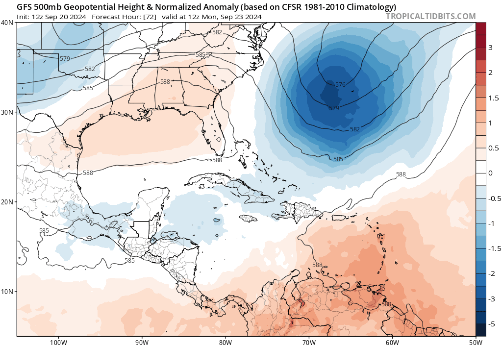
SFLcane

- S2K Supporter
- Posts: 10281
- Age: 48
- Joined: Sat Jun 05, 2010 1:44 pm
- Location: Lake Worth Florida
Re: Area of low pressure to develop over the western Caribbean Sea
gatorcane wrote:AutoPenalti wrote:GFS continues to push back the trough timing and allows the ridge to build over Florida.
Yep, GFS saved loop. A FL peninsula hit not looking likely with that 500MB setup and the CMC has even a stronger ridge. Northern Gulf coast on the other hand...
https://i.postimg.cc/Nfmk4RTS/gfs-z500a-Norm-watl-fh72-168.gif
"Florida Shield"
1 likes
-
DunedinDave
- Category 1
- Posts: 269
- Joined: Fri Aug 25, 2023 10:31 am
Re: Area of low pressure to develop over the western Caribbean Sea
SFLcane wrote:gatorcane wrote:AutoPenalti wrote:GFS continues to push back the trough timing and allows the ridge to build over Florida.
Yep, GFS saved loop. A FL peninsula hit not looking likely with that 500MB setup and the CMC has even a stronger ridge. Northern Gulf coast on the other hand...
https://i.postimg.cc/Nfmk4RTS/gfs-z500a-Norm-watl-fh72-168.gif
"Florida Shield"
Amazing. We dodged another one.
1 likes
-
toad strangler

- S2K Supporter
- Posts: 4546
- Joined: Sun Jul 28, 2013 3:09 pm
- Location: Earth
- Contact:
Re: Area of low pressure to develop over the western Caribbean Sea
FWIW, GEFS is still all over the place with a significant amount of members W of say Pensacola longitude and another group E of the there.
Last edited by toad strangler on Fri Sep 20, 2024 12:10 pm, edited 1 time in total.
0 likes
My Weather Station
https://www.wunderground.com/dashboard/pws/KFLPORTS603
https://www.wunderground.com/dashboard/pws/KFLPORTS603
Who is online
Users browsing this forum: Ulf and 174 guests