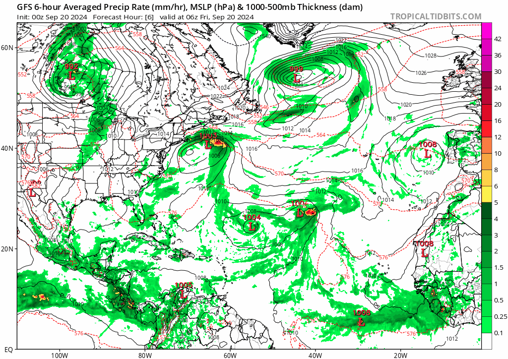
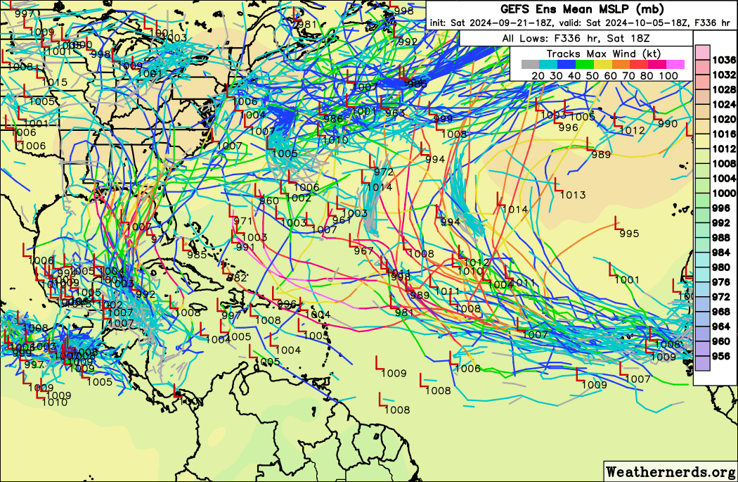
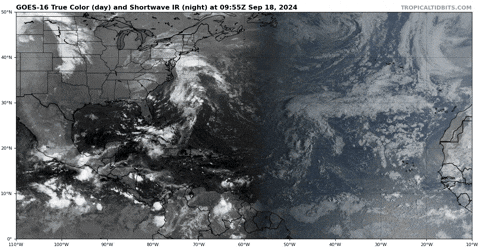
2024 Global Model Runs Discussion (Out thru day 16)

This is the general tropical discussion area. Anyone can take their shot at predicting a storms path.

Moderator: S2k Moderators

Forum rules

The posts in this forum are NOT official forecasts and should not be used as such. They are just the opinion of the poster and may or may not be backed by sound meteorological data. They are NOT endorsed by any professional institution or STORM2K. For official information, please refer to products from the National Hurricane Center and National Weather Service.

Help Support Storm2K
Message
Author
User avatar
REDHurricane
Category 1
Category 1
Posts: 396
Age: 27
Joined: Sun Jul 03, 2022 2:36 pm
Location: Northeast Pacific Ocean

Re: 2024 Global Model Runs Discussion (Out thru day 16)

#2061 Postby REDHurricane » Thu Sep 19, 2024 11:40 pm

Steve wrote:
REDHurricane wrote:Regardless of what models are saying could happen in the 7-14 day time frame, it's kind of shocking to see the MDR and Caribbean/Gulf (especially the MDR) completely barren of convective activity in the middle of September like this:

https://media4.giphy.com/media/v1.Y2lkPTc5MGI3NjExNnRxNW5wY2RoNHlqcXZ6bWhibGlpeDVmMGpmbjZjajl2dWVpeHllZiZlcD12MV9pbnRlcm5hbF9naWZfYnlfaWQmY3Q9Zw/pPadHtZSUGdu8zHv4h/giphy.gif


I don’t agree Red. It’s literally predictable and not shocking at all. There’s supposed to be sinking and stable air across most of the Atlantic. We been in Phases 4, 5 and 6 of the MJO since July 25th. These aren’t upward motion phases for the majority of the Atlantic though there are some minor corridors. But overall those phases don’t lend to multiple storms across the Atlantic.


I don't know, given the consensus hyperactive preseason forecasts from the experts (and everyone here, myself and probably you included) I think it's definitely reasonable to deem it "kind of shocking" that the entire MDR, entire Caribbean, and entire Gulf were all apparently devoid of even the slightest sustained convection on September 18th, i.e. 8 days removed from the climatological peak of the hurricane season, even with an unfavorable MJO
4 likes   

User avatar
Teban54
Category 5
Category 5
Posts: 3204
Joined: Sat May 19, 2018 1:19 pm

Re: 2024 Global Model Runs Discussion (Out thru day 16)

#2062 Postby Teban54 » Fri Sep 20, 2024 1:33 am

It's La La Land, but I guess people were too focused on the CAG to notice that the rest of 0z GFS is actually very active.

Image
4 likes   

AxaltaRacing24
Category 5
Category 5
Posts: 1753
Age: 25
Joined: Wed Jul 27, 2016 11:14 am
Location: Jupiter, FL

Re: 2024 Global Model Runs Discussion (Out thru day 16)

#2063 Postby AxaltaRacing24 » Fri Sep 20, 2024 2:53 am

Teban54 wrote:It's La La Land, but I guess people were too focused on the CAG to notice that the rest of 0z GFS is actually very active.

https://i.postimg.cc/GhzgYxT1/gfs-mslp-pcpn-atl-fh6-384.gif

After all that, this just might end up being another backloaded La Niña season.
3 likes   

jlauderdal
S2K Supporter
S2K Supporter
Posts: 7182
Joined: Wed May 19, 2004 5:46 am
Location: NE Fort Lauderdale
Contact:

Re: 2024 Global Model Runs Discussion (Out thru day 16)

#2064 Postby jlauderdal » Fri Sep 20, 2024 7:14 am

Teban54 wrote:It's La La Land, but I guess people were too focused on the CAG to notice that the rest of 0z GFS is actually very active.

https://i.postimg.cc/GhzgYxT1/gfs-mslp-pcpn-atl-fh6-384.gif

Ridge building in behind the gyre system could be big trouble for the central atlantic system being modeled.
0 likes   

Cachondo23
Tropical Depression
Tropical Depression
Posts: 75
Joined: Wed May 25, 2022 5:56 am

Re: 2024 Global Model Runs Discussion (Out thru day 16)

#2065 Postby Cachondo23 » Fri Sep 20, 2024 1:14 pm

One more shot in the MDR/CV season?

Maybe something like Tammy 2023 but earlier dates.
0 likes   

User avatar
Teban54
Category 5
Category 5
Posts: 3204
Joined: Sat May 19, 2018 1:19 pm

Re: 2024 Global Model Runs Discussion (Out thru day 16)

#2066 Postby Teban54 » Fri Sep 20, 2024 1:18 pm

Cachondo23 wrote:One more shot in the MDR/CV season?

Maybe something like Tammy 2023 but earlier dates.

If long-range GFS is to be believed, it has been suggesting over the past few runs that we may get two CV hurricanes in the next 16 days.
0 likes   

User avatar
Steve
S2K Supporter
S2K Supporter
Posts: 9621
Joined: Sat Apr 05, 2003 11:41 pm
Location: Not a state-caster

Re: 2024 Global Model Runs Discussion (Out thru day 16)

#2067 Postby Steve » Fri Sep 20, 2024 1:36 pm

REDHurricane wrote:
Steve wrote:
REDHurricane wrote:Regardless of what models are saying could happen in the 7-14 day time frame, it's kind of shocking to see the MDR and Caribbean/Gulf (especially the MDR) completely barren of convective activity in the middle of September like this:

https://media4.giphy.com/media/v1.Y2lkPTc5MGI3NjExNnRxNW5wY2RoNHlqcXZ6bWhibGlpeDVmMGpmbjZjajl2dWVpeHllZiZlcD12MV9pbnRlcm5hbF9naWZfYnlfaWQmY3Q9Zw/pPadHtZSUGdu8zHv4h/giphy.gif


I don’t agree Red. It’s literally predictable and not shocking at all. There’s supposed to be sinking and stable air across most of the Atlantic. We been in Phases 4, 5 and 6 of the MJO since July 25th. These aren’t upward motion phases for the majority of the Atlantic though there are some minor corridors. But overall those phases don’t lend to multiple storms across the Atlantic.


I don't know, given the consensus hyperactive preseason forecasts from the experts (and everyone here, myself and probably you included) I think it's definitely reasonable to deem it "kind of shocking" that the entire MDR, entire Caribbean, and entire Gulf were all apparently devoid of even the slightest sustained convection on September 18th, i.e. 8 days removed from the climatological peak of the hurricane season, even with an unfavorable MJO


We may find out from next week until possibly the middle of October. These things change frequently, but a bunch of models are showing a return to favorable phases we haven't been in since July (which isn't itself generally favorable). We'll have to check it the next several days to see if in fact we're heading for 8, 1 and/or 2. But for now:

NCPE (GEFS)
Image

NCPB (NCEP bias-corrected)
Image

CFSv2 (Climate Forecast System) <-- pretty bullish on the 9/28 - 10/15 period
Image

JMAN (only goes out next 11 days)
Image

ECMWF (15 days and is the least bullish besides the Australian)
Image

Overall the first 2 weeks of October should feature at least a few named Atlantic storms if these forecasts continue.
3 likes   

User avatar
Kazmit
Category 5
Category 5
Posts: 2124
Age: 22
Joined: Mon Jul 25, 2016 8:49 am
Location: Williamsburg, VA / Bermuda

Re: 2024 Global Model Runs Discussion (Out thru day 16)

#2068 Postby Kazmit » Fri Sep 20, 2024 1:36 pm

Three systems at once.

Image
4 likes   
Igor 2010, Sandy 2012, Fay 2014, Gonzalo 2014, Joaquin 2015, Nicole 2016, Humberto 2019

I am only a tropical weather enthusiast. My predictions are not official and may or may not be backed by sound meteorological data. For official information, please refer to the NHC and NWS products.

User avatar
Steve
S2K Supporter
S2K Supporter
Posts: 9621
Joined: Sat Apr 05, 2003 11:41 pm
Location: Not a state-caster

Re: 2024 Global Model Runs Discussion (Out thru day 16)

#2069 Postby Steve » Fri Sep 20, 2024 1:40 pm

Kazmit wrote:Three systems at once.

https://i.ibb.co/vVc1TJ3/gfs-mslp-pcpn-watl-64.png


That's right in the time frame where the models see the MJO back in the Western Hemisphere. I haven't checked on CCKW's though so maybe there is an enhancing one coming across?
1 likes   

KeysRedWine
Tropical Wave
Tropical Wave
Posts: 3
Age: 41
Joined: Thu Sep 19, 2024 12:30 pm
Location: Summerland Key, FL

Re: 2024 Global Model Runs Discussion (Out thru day 16)

#2070 Postby KeysRedWine » Fri Sep 20, 2024 1:53 pm

Long time lurker, first time poster. I must say that the last few days of GFS runs have gotten me worried. And then yesterdays (9/19) 12z GFS run finally pushed me to register on Storm2k. That was a GFS run for the ages for Florida! I also want to thank everyone for sharing their knowledge and posting the data on this forum. 8-)
9 likes   

User avatar
StPeteMike
Category 2
Category 2
Posts: 631
Joined: Thu Jun 07, 2018 11:26 pm

Re: 2024 Global Model Runs Discussion (Out thru day 16)

#2071 Postby StPeteMike » Fri Sep 20, 2024 2:18 pm

Y’all said it was quiet and Mother Nature heard load and clear.

Did any of you knock on wood after making such statements?!? lol
1 likes   
The above post is not official and should not be used as such. It is the opinion of the poster and may or may not be backed by sound meteorological data. It is not endorsed by any professional institution or storm2k.org. For official information, please refer to the NHC and NWS products.

User avatar
Hammy
Category 5
Category 5
Posts: 5849
Age: 41
Joined: Fri May 25, 2012 5:25 pm
Contact:

Re: 2024 Global Model Runs Discussion (Out thru day 16)

#2072 Postby Hammy » Fri Sep 20, 2024 2:32 pm

StPeteMike wrote:Y’all said it was quiet and Mother Nature heard load and clear.

Did any of you knock on wood after making such statements?!? lol


I'm willing to bet not one of those MDR storms actually develops :lol:

Teban54 wrote:It's La La Land, but I guess people were too focused on the CAG to notice that the rest of 0z GFS is actually very active.

https://i.postimg.cc/GhzgYxT1/gfs-mslp-pcpn-atl-fh6-384.gif


I'd seriously keep a very close eye on that CAG--as we saw in June, it seems displaced to the northeast compared to normal, and we had Alberto, an invest that could easily have been classified a depression, and then Chris (from a wave, but interacted with CAG in order to form) all in the span of two weeks, and conditions are far more favorable in the western Gulf now than they were in June, as we saw with Francine.
0 likes   
The above post is not official and should not be used as such. It is the opinion of the poster and may or may not be backed by sound meteorological data. It is not endorsed by any professional institution or storm2k.org. For official information, please refer to the NHC and NWS products.

User avatar
Woofde
Category 1
Category 1
Posts: 479
Joined: Tue Jul 06, 2021 11:33 am

Re: 2024 Global Model Runs Discussion (Out thru day 16)

#2073 Postby Woofde » Fri Sep 20, 2024 2:38 pm

Steve wrote:
REDHurricane wrote:
Steve wrote:

I don’t agree Red. It’s literally predictable and not shocking at all. There’s supposed to be sinking and stable air across most of the Atlantic. We been in Phases 4, 5 and 6 of the MJO since July 25th. These aren’t upward motion phases for the majority of the Atlantic though there are some minor corridors. But overall those phases don’t lend to multiple storms across the Atlantic.


I don't know, given the consensus hyperactive preseason forecasts from the experts (and everyone here, myself and probably you included) I think it's definitely reasonable to deem it "kind of shocking" that the entire MDR, entire Caribbean, and entire Gulf were all apparently devoid of even the slightest sustained convection on September 18th, i.e. 8 days removed from the climatological peak of the hurricane season, even with an unfavorable MJO


We may find out from next week until possibly the middle of October. These things change frequently, but a bunch of models are showing a return to favorable phases we haven't been in since July (which isn't itself generally favorable). We'll have to check it the next several days to see if in fact we're heading for 8, 1 and/or 2. But for now:

NCPE (GEFS)
Image

NCPB (NCEP bias-corrected)
Image

CFSv2 (Climate Forecast System) <-- pretty bullish on the 9/28 - 10/15 period
Image

JMAN (only goes out next 11 days)
Image

ECMWF (15 days and is the least bullish besides the Australian)
Image

Overall the first 2 weeks of October should feature at least a few named Atlantic storms if these forecasts continue.
Wow, yeah that would be a seriously amped up MJO signal. It's spiking instead of the usual peter off during 8,1,2. Maybe that'll be the kickstart this season requires for any major activity. We're fast approaching the end, but I'd say this period between the Gyre storm and maybe some MDR seeds taking advantage of the MJO could be it's best chance yet.
2 likes   

User avatar
WaveBreaking
Category 2
Category 2
Posts: 578
Joined: Sun Jun 30, 2024 11:33 am
Location: US

Re: 2024 Global Model Runs Discussion (Out thru day 16)

#2074 Postby WaveBreaking » Fri Sep 20, 2024 6:46 pm

Happy Hour GFS never disappoints :lol:

Image
2 likes   
I am NOT a professional meteorologist, so take all of my posts with a grain of salt. My opinions are mine and mine alone.

User avatar
MetroMike
Category 4
Category 4
Posts: 952
Joined: Sun Aug 29, 2004 8:13 pm
Location: Tampa Bay
Contact:

Re: 2024 Global Model Runs Discussion (Out thru day 16)

#2075 Postby MetroMike » Fri Sep 20, 2024 6:53 pm

Like I said earlier it shall be gone in the 0z run.
1 likes   

User avatar
Steve
S2K Supporter
S2K Supporter
Posts: 9621
Joined: Sat Apr 05, 2003 11:41 pm
Location: Not a state-caster

Re: 2024 Global Model Runs Discussion (Out thru day 16)

#2076 Postby Steve » Fri Sep 20, 2024 9:02 pm

MetroMike wrote:Like I said earlier it shall be gone in the 0z run.


It’s been a heavy Gulf year so far though. So no reason there couldn’t be a couple more hurricane hits and maybe a late October sheared TS. We’ve just been fortunate that nothing hit super strong as of yet. Season may well have more surprises in store and possibly sooner than later.
3 likes   

User avatar
cheezyWXguy
Category 5
Category 5
Posts: 6108
Joined: Mon Feb 13, 2006 12:29 am
Location: Dallas, TX

Re: 2024 Global Model Runs Discussion (Out thru day 16)

#2077 Postby cheezyWXguy » Sat Sep 21, 2024 1:11 am

Steve wrote:
MetroMike wrote:Like I said earlier it shall be gone in the 0z run.


It’s been a heavy Gulf year so far though. So no reason there couldn’t be a couple more hurricane hits and maybe a late October sheared TS. We’ve just been fortunate that nothing hit super strong as of yet. Season may well have more surprises in store and possibly sooner than later.

Narrator: It wasn’t gone in the 0z run

0z gefs likes it too. And it looks like 2 other waves in the mdr. Long way out, so not much stock to put into it yet, but a back-loaded season could still be on the table after all.
7 likes   

User avatar
Teban54
Category 5
Category 5
Posts: 3204
Joined: Sat May 19, 2018 1:19 pm

Re: 2024 Global Model Runs Discussion (Out thru day 16)

#2078 Postby Teban54 » Sat Sep 21, 2024 10:37 pm

Unlike the operational runs, 18z GEFS actually trended upwards in intensity with the 0/40 MDR wave. In addition to the recurving members (with many making it a hurricane), a few members also show a ridge pushing the system W or WSW to north of Lesser Antilles, where it then becomes a formidable major. Obviously that's unlikely now, but 6z GEFS shows a few similar tracks, just with the wave behind it.

Image
0 likes   

SconnieCane
Category 4
Category 4
Posts: 998
Joined: Thu Aug 02, 2018 5:29 pm
Location: Madison, WI

Re: 2024 Global Model Runs Discussion (Out thru day 16)

#2079 Postby SconnieCane » Sat Sep 21, 2024 11:23 pm

18Z GFS had another major hurricane forming in the Caribbean and striking the Florida Gulf Coast, behind the potential one we've all been watching for days. :eek: :double:
0 likes   

User avatar
MetroMike
Category 4
Category 4
Posts: 952
Joined: Sun Aug 29, 2004 8:13 pm
Location: Tampa Bay
Contact:

Re: 2024 Global Model Runs Discussion (Out thru day 16)

#2080 Postby MetroMike » Sun Sep 22, 2024 12:17 am

SconnieCane wrote:18Z GFS had another major hurricane forming in the Caribbean and striking the Florida Gulf Coast, behind the potential one we've all been watching for days. :eek: :double:


And again the 0z GFS has another perhaps MH right up the spine of Fl about 10 days after.
Crazy! I bet it will change though.
1 likes   


Return to “Talkin' Tropics”

Who is online

Users browsing this forum: No registered users and 47 guests