
While we are at it, WV shows what I think is a mid level swirl to the north of the convection. It shows up on visible with the SW shear on the clouds north of the convection. Ain’t nothing forming until this backs off SW and gets replaced by ridging.
https://www.tropicaltidbits.com/sat/sat ... uct=wv_mid
Low pressure developing over the western Caribbean Sea (Is Invest 97L)
Moderator: S2k Moderators
Forum rules

The posts in this forum are NOT official forecasts and should not be used as such. They are just the opinion of the poster and may or may not be backed by sound meteorological data. They are NOT endorsed by any professional institution or STORM2K. For official information, please refer to products from the National Hurricane Center and National Weather Service.
-
TomballEd
- Category 5

- Posts: 1293
- Age: 62
- Joined: Wed Aug 16, 2023 4:52 pm
- Location: Spring/Klein area, not Tomball
Re: Area of low pressure to develop over the western Caribbean sea (0/60)
More likely Wednesday or Thursday, but this could be a storm by late Tuesday. That leaves four days of watching the various model runs and choosing a favorite landfall location and intensity.
0 likes
-
floridasun
- Tropical Storm

- Posts: 245
- Joined: Tue Sep 14, 2021 3:59 pm
Re: Area of low pressure to develop over the western Caribbean sea (0/60)
so area need watch this area iis from Myers, Florida to houston tx ? or only from big bend to new Orlean?
0 likes
-
StPeteMike

- Category 2

- Posts: 656
- Joined: Thu Jun 07, 2018 11:26 pm
Re: Area of low pressure to develop over the western Caribbean sea (0/60)
Steve wrote:Ubuntwo wrote:Off topic, but the chatter yesterday about the longest pre-invest thread made me look. It's not pre-Francine contrary to the popular belief. Pre-Nicole in 2010 had 1,461 posts/74 pages (!) before being designated as invest 96L. It was a SFL model storm which ended up peaking as a 40kt tropical storm dissipating after crossing Cuba. We've got a ways to go with this one.
I’ll raise you one visible satellite of the area featuring a nice outflow boundary.
https://www.tropicaltidbits.com/sat/sat ... t=vis_swir
Can see what is the likely issues with the current models, IMO, is the numerous vortices on both sides of CA. You got one just off the El Salvador coast, another the southeast there, and about two off of Honduras in the Caribbean.
It’s been a beaten down horse, but we will not know until something can gain dominance with the CAG and the models can latch onto one thing instead of struggling with 3.
1 likes
The above post is not official and should not be used as such. It is the opinion of the poster and may or may not be backed by sound meteorological data. It is not endorsed by any professional institution or storm2k.org. For official information, please refer to the NHC and NWS products.
-
StPeteMike
- Category 2
- Posts: 656
- Joined: Thu Jun 07, 2018 11:26 pm
Re: Area of low pressure to develop over the western Caribbean sea (0/60)
floridasun wrote:so area need watch this area iis from Myers, Florida to houston tx ? or only from big bend to new Orlean?
All of the Gulf Coast, except maybe Brownsville area. But until we have a storm and it’s in the gulf or about to enter the gulf, it’s hard to say. We’re still 3 days from something getting close to the GoM.
1 likes
The above post is not official and should not be used as such. It is the opinion of the poster and may or may not be backed by sound meteorological data. It is not endorsed by any professional institution or storm2k.org. For official information, please refer to the NHC and NWS products.
-
jlauderdal
- S2K Supporter

- Posts: 7240
- Joined: Wed May 19, 2004 5:46 am
- Location: NE Fort Lauderdale
- Contact:
Re: Area of low pressure to develop over the western Caribbean sea (0/60)
Fort Myers to Mobile but a big storm so north and east well away on alertfloridasun wrote:so area need watch this area iis from Myers, Florida to houston tx ? or only from big bend to new Orlean?
1 likes
Re: Area of low pressure to develop over the western Caribbean sea (0/60)
jlauderdal wrote:Fort Myers to Mobile but a big storm so north and east well away on alertfloridasun wrote:so area need watch this area iis from Myers, Florida to houston tx ? or only from big bend to new Orlean?
Ft Myers to Mobile?? How anyone can narrow down an area with NOTHING is a mystery.
0 likes
Re: Area of low pressure to develop over the western Caribbean sea (0/60)
StPeteMike wrote:Steve wrote:Ubuntwo wrote:Off topic, but the chatter yesterday about the longest pre-invest thread made me look. It's not pre-Francine contrary to the popular belief. Pre-Nicole in 2010 had 1,461 posts/74 pages (!) before being designated as invest 96L. It was a SFL model storm which ended up peaking as a 40kt tropical storm dissipating after crossing Cuba. We've got a ways to go with this one.
I’ll raise you one visible satellite of the area featuring a nice outflow boundary.
https://www.tropicaltidbits.com/sat/sat ... t=vis_swir
Can see what is the likely issues with the current models, IMO, is the numerous vortices on both sides of CA. You got one just off the El Salvador coast, another the southeast there, and about two off of Honduras in the Caribbean.
It’s been a beaten down horse, but we will not know until something can gain dominance with the CAG and the models can latch onto one thing instead of struggling with 3.
That’s right Mike and why I’ve mostly stuck to discussing the model outputs as they were released. There was always going to be a wide range of possibilities. It’s narrowing down as we get closer. The players on the field are the low north of the disturbance, a big high over the south and the upper low over the 4 corners as well as that trough you can see coming into Washington state.
https://www.tropicaltidbits.com/sat/sat ... uct=wv_mid
4 likes
-
TomballEd
- Category 5
- Posts: 1293
- Age: 62
- Joined: Wed Aug 16, 2023 4:52 pm
- Location: Spring/Klein area, not Tomball
Re: Area of low pressure to develop over the western Caribbean sea (0/60)ile
Steve wrote:While we are at it, WV shows what I think is a mid level swirl to the north of the convection. It shows up on visible with the SW shear on the clouds north of the convection. Ain’t nothing forming until this backs off SW and gets replaced by ridging.
https://www.tropicaltidbits.com/sat/sat ... uct=wv_mid
I believe that is the trough that is supposed to help fire up the convection in the Caribbean that probably develops into a TC. It is a needed trigger for convective initiation.
1 likes
Re: RE: Re: Area of low pressure to develop over the western Caribbean sea (0/60)
3090 wrote:jlauderdal wrote:Fort Myers to Mobile but a big storm so north and east well away on alertfloridasun wrote:so area need watch this area iis from Myers, Florida to houston tx ? or only from big bend to new Orlean?
Ft Myers to Mobile?? How anyone can narrow down an area with NOTHING is a mystery.
Anyone can guess. I think more Plaquemines Parish to Dixie County with an emphasis on Harrison Co. MS to Apalachicola. That’s based on setup which certainly will evolve next week.
1 likes
Re: Area of low pressure to develop over the western Caribbean sea (0/60)ile
TomballEd wrote:Steve wrote:While we are at it, WV shows what I think is a mid level swirl to the north of the convection. It shows up on visible with the SW shear on the clouds north of the convection. Ain’t nothing forming until this backs off SW and gets replaced by ridging.
https://www.tropicaltidbits.com/sat/sat ... uct=wv_mid
I believe that is the trough that is supposed to help fire up the convection in the Caribbean that probably develops into a TC. It is a needed trigger for convective initiation.
Yeah but pattern has to reverse.
1 likes
-
jlauderdal
- S2K Supporter
- Posts: 7240
- Joined: Wed May 19, 2004 5:46 am
- Location: NE Fort Lauderdale
- Contact:
Re: Area of low pressure to develop over the western Caribbean sea (0/60)
I will narrow it more tomorrow, most likely on the western side.3090 wrote:jlauderdal wrote:Fort Myers to Mobile but a big storm so north and east well away on alertfloridasun wrote:so area need watch this area iis from Myers, Florida to houston tx ? or only from big bend to new Orlean?
Ft Myers to Mobile?? How anyone can narrow down an area with NOTHING is a mystery.
0 likes
-
TomballEd
- Category 5
- Posts: 1293
- Age: 62
- Joined: Wed Aug 16, 2023 4:52 pm
- Location: Spring/Klein area, not Tomball
Re: Area of low pressure to develop over the western Caribbean sea (0/60)
Quick glance at GFS, Euro and Canadian ensemble conus heights, this getting to the Upper Texas Coast would require Divine intervention. Mid level NW flow over the NW Gulf is not how Caribbean storms reach Texas. Impossible, no, extremely unlikely, yes. Not a single Euro or GFS ensemble model has a Texas landfall. One of the GEFS members tries, but the system hooks beyond a 90 degree right turn before it gets close. Even cooler is the lone EPS member that hooks a hard left before it gets to Texas.
I don't think the ensembles are that lost on what the 500 mb pattern will be in a week. Enough ECENS still have landfalls further W than Florida that I wouldn't rule out a landfall as far W as Cocodrie, where a ginat horsefly bit me while I was changing a tire. Terrebonne Parish roads are bad enough to blow tires.
I don't think the ensembles are that lost on what the 500 mb pattern will be in a week. Enough ECENS still have landfalls further W than Florida that I wouldn't rule out a landfall as far W as Cocodrie, where a ginat horsefly bit me while I was changing a tire. Terrebonne Parish roads are bad enough to blow tires.
1 likes
-
Blown Away

- S2K Supporter
- Posts: 10253
- Joined: Wed May 26, 2004 6:17 am
Re: Area of low pressure to develop over the western Caribbean sea (0/60)

12z ECENS
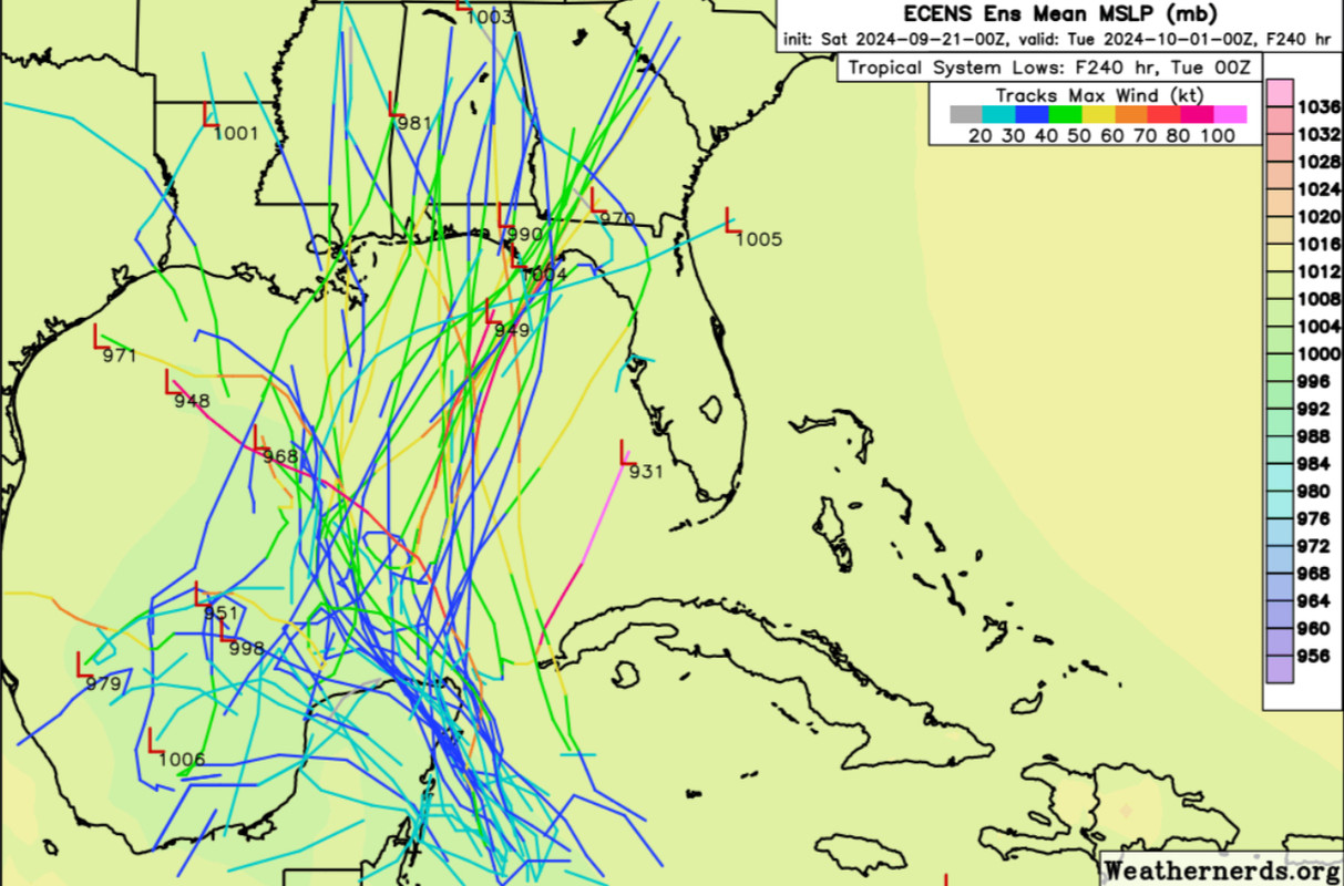
ECENS from 00z to 12z…
2 likes
Hurricane Eye Experience: David 79, Irene 99, Frances 04, Jeanne 04, Wilma 05… Hurricane Brush Experience: Andrew 92, Erin 95, Floyd 99, Matthew 16, Irma 17, Ian 22, Nicole 22…
-
floridasun
- Tropical Storm
- Posts: 245
- Joined: Tue Sep 14, 2021 3:59 pm
Re: RE: Re: RE: Re: Area of low pressure to develop over the western Caribbean sea (0/60)
western side?jlauderdal wrote:I will narrow it more tomorrow, most likely on the western side.3090 wrote:jlauderdal wrote:Fort Myers to Mobile but a big storm so north and east well away on alert
Ft Myers to Mobile?? How anyone can narrow down an area with NOTHING is a mystery.
0 likes
-
MarioProtVI
- Category 5
- Posts: 1034
- Age: 24
- Joined: Sun Sep 29, 2019 7:33 pm
- Location: New Jersey
Re: Area of low pressure to develop over the western Caribbean sea (0/60)
Blown Away wrote:[url]https://i.postimg.cc/90sDfpjq/IMG-0263.jpg [/url]
12z ECENS
[url]https://i.postimg.cc/Vvz8W0BH/IMG-0264.jpg [/url]
ECENS from 00z to 12z…
Definitely a downtick in intensity
0 likes
Re: RE: Re: RE: Re: Area of low pressure to develop over the western Caribbean sea (0/60)
floridasun wrote:western side?jlauderdal wrote:I will narrow it more tomorrow, most likely on the western side.3090 wrote:Ft Myers to Mobile?? How anyone can narrow down an area with NOTHING is a mystery.
Sun how you doing with that transplant?
——————
18z ICON with weaker EPAC action than 12z. Only a slight 1007mb low in the Caribbean at 57 hours though.
https://www.tropicaltidbits.com/analysi ... 2118&fh=57
0 likes
-
Weathertracker96
- Tropical Storm
- Posts: 150
- Joined: Mon Oct 16, 2023 3:41 pm
Re: Area of low pressure to develop over the western Caribbean sea (0/60)
I don't know if its been posted but the Euro- AI shifted east to near the big bend of FL. Still know we have no center so not surprised the models are jumping around.
1 likes
-
jlauderdal
- S2K Supporter
- Posts: 7240
- Joined: Wed May 19, 2004 5:46 am
- Location: NE Fort Lauderdale
- Contact:
Re: Area of low pressure to develop over the western Caribbean sea (0/60)
I will move my target east of mobile, will see.floridasun wrote:western side?jlauderdal wrote:I will narrow it more tomorrow, most likely on the western side.3090 wrote:Ft Myers to Mobile?? How anyone can narrow down an area with NOTHING is a mystery.
0 likes
-
floridasun
- Tropical Storm
- Posts: 245
- Joined: Tue Sep 14, 2021 3:59 pm
Re: Area of low pressure to develop over the western Caribbean sea (0/60)
Steve wrote:floridasun wrote:western side?jlauderdal wrote:I will narrow it more tomorrow, most likely on the western side.
Sun how you doing with that transplant?
——————
18z ICON with weaker EPAC action than 12z. Only a slight 1007mb low in the Caribbean at 57 hours though.
https://www.tropicaltidbits.com/analysi ... 2118&fh=57
good blood test coming out good now almost 6 months
1 likes
Who is online
Users browsing this forum: Teban54 and 211 guests