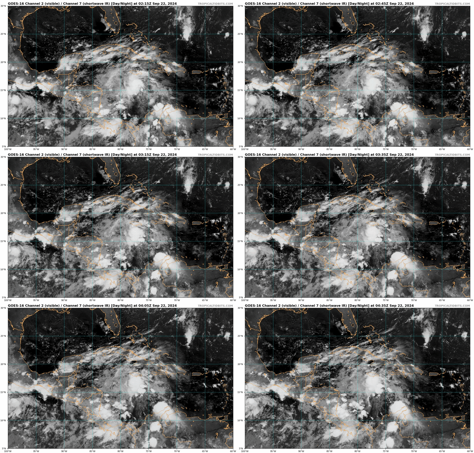
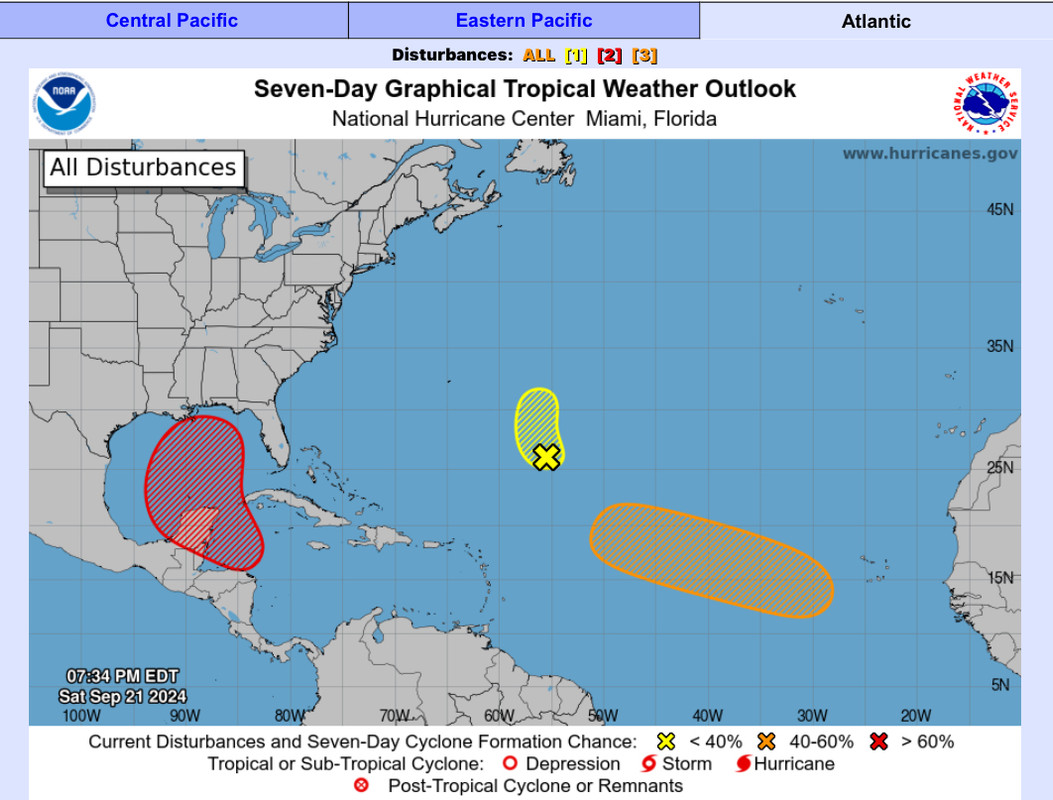
Low pressure developing over the western Caribbean Sea (Is Invest 97L)

This is the general tropical discussion area. Anyone can take their shot at predicting a storms path.

Moderator: S2k Moderators

Forum rules

The posts in this forum are NOT official forecasts and should not be used as such. They are just the opinion of the poster and may or may not be backed by sound meteorological data. They are NOT endorsed by any professional institution or STORM2K. For official information, please refer to products from the National Hurricane Center and National Weather Service.

Help Support Storm2K
Message
Author
User avatar
jfk08c
S2K Supporter
S2K Supporter
Posts: 204
Joined: Mon Jun 11, 2018 4:36 pm
Location: Lakeland, FL

Re: Area of low pressure to develop over the western Caribbean sea (0/70)

#1021 Postby jfk08c » Sat Sep 21, 2024 11:35 pm

Hammy wrote:Canadian and European seem to be the in the most agreement, with the GFS being an outlier. IF the latest Canadian plays out we'll probably get another unnamed PTC out of this and not much more.


If you throw the Euro AI in with them, it has basically the exact same landfall location as the latest GFS, albeit a little weaker
0 likes   

User avatar
Blown Away
S2K Supporter
S2K Supporter
Posts: 10145
Joined: Wed May 26, 2004 6:17 am

Re: Area of low pressure to develop over the western Caribbean sea (0/70)

#1022 Postby Blown Away » Sat Sep 21, 2024 11:38 pm

Hammy wrote:Canadian and European seem to be the in the most agreement, with the GFS being an outlier. IF the latest Canadian plays out we'll probably get another unnamed PTC out of this and not much more.


CMC has been adjusting E a few hundred miles each of its past few runs…
0 likes   
Hurricane Eye Experience: David 79, Irene 99, Frances 04, Jeanne 04, Wilma 05... EYE COMING MY WAY IN 2024…
Hurricane Brush Experience: Andrew 92, Erin 95, Floyd 99, Matthew 16, Irma 17, Ian 22, Nicole 22…

User avatar
Steve
S2K Supporter
S2K Supporter
Posts: 9621
Joined: Sat Apr 05, 2003 11:41 pm
Location: Not a state-caster

Re: Area of low pressure to develop over the western Caribbean sea (0/70)

#1023 Postby Steve » Sat Sep 21, 2024 11:48 pm

sponger wrote:Changing the gen oil tomorrow and starting the slow build up of Ethanol free fuel. I never take lightly a Fall Low South and West of me. Especially with that low shear forecast and good ventilation.


Good to see you.
1 likes   

User avatar
MetroMike
Category 4
Category 4
Posts: 952
Joined: Sun Aug 29, 2004 8:13 pm
Location: Tampa Bay
Contact:

Re: Area of low pressure to develop over the western Caribbean sea (0/70)

#1024 Postby MetroMike » Sat Sep 21, 2024 11:50 pm

It's hard to imagine we don't even have an invest and the TC could hit the gulf coast before the week is over.
Quite a dicey situation for the NHC.
1 likes   

TomballEd
Category 2
Category 2
Posts: 692
Age: 61
Joined: Wed Aug 16, 2023 4:52 pm
Location: Spring/Klein area, not Tomball

Re: Area of low pressure to develop over the western Caribbean sea (0/70)

#1025 Postby TomballEd » Sat Sep 21, 2024 11:52 pm

Still a smidge early to lock in on one model or even one model run. One comment about the ICON run, someone said they think a hard right turn in the Gulf seems wrong, looking at the 500 mb pattern, whether it gets into the Gulf N of the BoC or the E. Gulf, it will eventually get caught by that trough even though the ICON and the GFS had pretty significant differences on the upper air pattern. Landfall locations close to each other, as is intensity, even if they take different paths at different times, and similar intensities. Ensembles are still the best tool, and even randomly tweaking various initial conditions may not capture where the actual center forms.

Free GFS ensembles on Tropical Tidbits only out to 132 hours, but there is still a spread, but Florida looks like it gets most of the landfalls with some members still offshore. There will be at least a day's worth of delta on the arrival time of the system, with the earliest landfalls very early Thursday.
0 likes   

User avatar
Blown Away
S2K Supporter
S2K Supporter
Posts: 10145
Joined: Wed May 26, 2004 6:17 am

Re: Area of low pressure to develop over the western Caribbean sea (0/70)

#1026 Postby Blown Away » Sat Sep 21, 2024 11:53 pm

Image
Image

I do find it interesting that most of the convection and rotation is occurring to the E of the potential development area…
1 likes   
Hurricane Eye Experience: David 79, Irene 99, Frances 04, Jeanne 04, Wilma 05... EYE COMING MY WAY IN 2024…
Hurricane Brush Experience: Andrew 92, Erin 95, Floyd 99, Matthew 16, Irma 17, Ian 22, Nicole 22…

User avatar
Blown Away
S2K Supporter
S2K Supporter
Posts: 10145
Joined: Wed May 26, 2004 6:17 am

Re: Area of low pressure to develop over the western Caribbean sea (0/70)

#1027 Postby Blown Away » Sun Sep 22, 2024 12:00 am

Image

00z ICON… Large shift E from 12z near LA now in line with GFS near FL Big Bend…
0 likes   
Hurricane Eye Experience: David 79, Irene 99, Frances 04, Jeanne 04, Wilma 05... EYE COMING MY WAY IN 2024…
Hurricane Brush Experience: Andrew 92, Erin 95, Floyd 99, Matthew 16, Irma 17, Ian 22, Nicole 22…

User avatar
MetroMike
Category 4
Category 4
Posts: 952
Joined: Sun Aug 29, 2004 8:13 pm
Location: Tampa Bay
Contact:

Re: Area of low pressure to develop over the western Caribbean sea (0/70)

#1028 Postby MetroMike » Sun Sep 22, 2024 12:04 am

Blown Away wrote:[url]https://i.postimg.cc/k5KDyWF9/icon-mslp-pcpn-watl-fh48-180.gif [/url]

00z ICON… Large shift E from 12z near LA now in line with GFS near FL Big Bend…


Not an unusual track for this time of year given current set-up
0 likes   

User avatar
Blown Away
S2K Supporter
S2K Supporter
Posts: 10145
Joined: Wed May 26, 2004 6:17 am

Re: Area of low pressure to develop over the western Caribbean sea (0/70)

#1029 Postby Blown Away » Sun Sep 22, 2024 12:07 am

MetroMike wrote:
Blown Away wrote:[url]https://i.postimg.cc/k5KDyWF9/icon-mslp-pcpn-watl-fh48-180.gif [/url]

00z ICON… Large shift E from 12z near LA now in line with GFS near FL Big Bend…


Not an unusual track for this time of year given current set-up


I do think the large W swing into Central GOM is unusual, I think the likely scenario now is a sharper turn more in line with climatology… JMHO
0 likes   
Hurricane Eye Experience: David 79, Irene 99, Frances 04, Jeanne 04, Wilma 05... EYE COMING MY WAY IN 2024…
Hurricane Brush Experience: Andrew 92, Erin 95, Floyd 99, Matthew 16, Irma 17, Ian 22, Nicole 22…

psyclone
S2K Supporter
S2K Supporter
Posts: 4762
Joined: Wed Aug 24, 2005 9:04 pm
Location: palm harbor fl

Re: Area of low pressure to develop over the western Caribbean sea (0/70)

#1030 Postby psyclone » Sun Sep 22, 2024 12:07 am

That's a wild shift in the models. Who knows what they will show in 24 hours.
0 likes   

CrazyC83
Professional-Met
Professional-Met
Posts: 34002
Joined: Tue Mar 07, 2006 11:57 pm
Location: Deep South, for the first time!

Re: Area of low pressure to develop over the western Caribbean sea (0/70)

#1031 Postby CrazyC83 » Sun Sep 22, 2024 12:09 am

It seems that a stronger storm is farther east and a weaker storm is farther west?

Despite being 0% for the next 2 days, I'd tag it as 97L ASAP, since we need the model runs as the thinking is that this could be a quick-hitter.
7 likes   

User avatar
Steve
S2K Supporter
S2K Supporter
Posts: 9621
Joined: Sat Apr 05, 2003 11:41 pm
Location: Not a state-caster

Re: Area of low pressure to develop over the western Caribbean sea (0/70)

#1032 Postby Steve » Sun Sep 22, 2024 12:12 am

MetroMike wrote:
Blown Away wrote:[url]https://i.postimg.cc/k5KDyWF9/icon-mslp-pcpn-watl-fh48-180.gif [/url]

00z ICON… Large shift E from 12z near LA now in line with GFS near FL Big Bend…


Not an unusual track for this time of year given current set-up


No but that pressure is way low from what we’d typically see in that area. There might have been a couple systems, if that, in the last 200 years that got into the 940’s and hit the big bend. Idalia got to 950 (I think?) last year and was historic. This would be in that range back to back years which would be unprecedented. Not saying it can’t happen but it’s suspect at 949.
3 likes   

TomballEd
Category 2
Category 2
Posts: 692
Age: 61
Joined: Wed Aug 16, 2023 4:52 pm
Location: Spring/Klein area, not Tomball

Re: Area of low pressure to develop over the western Caribbean sea (0/70)

#1033 Postby TomballEd » Sun Sep 22, 2024 12:14 am

psyclone wrote:That's a wild shift in the models. Who knows what they will show in 24 hours.


I'll trust the models more after Monday's recon (listed as possible for the succeeding day on tomorrow's POD, but I'm thinking very likely). But even if the GFS and ICON are days different and take very different paths, they do get to about the same place with about the same intensity.
0 likes   

User avatar
Blown Away
S2K Supporter
S2K Supporter
Posts: 10145
Joined: Wed May 26, 2004 6:17 am

Re: Area of low pressure to develop over the western Caribbean sea (0/70)

#1034 Postby Blown Away » Sun Sep 22, 2024 12:16 am

Steve wrote:
MetroMike wrote:
Blown Away wrote:[url]https://i.postimg.cc/k5KDyWF9/icon-mslp-pcpn-watl-fh48-180.gif [/url]

00z ICON… Large shift E from 12z near LA now in line with GFS near FL Big Bend…


Not an unusual track for this time of year given current set-up


No but that pressure is way low from what we’d typically see in that area. There might have been a couple systems, if that, in the last 200 years that got into the 940’s and hit the big bend. Idalia got to 950 (I think?) last year and was historic. This would be in that range back to back years which would be unprecedented. Not saying it can’t happen but it’s suspect at 949.


Agree, to see that pressure in the area between Cedar Key to Appalachicola is eye opening, tells me conditions could be really good… Even though Big Bend area has had a few hits recently, it’s still a very rare location for hurricane landfall… I’d expect a trend W of Panama City or Ft Myers to the S, that’s what climatology says…
Last edited by Blown Away on Sun Sep 22, 2024 12:18 am, edited 1 time in total.
2 likes   
Hurricane Eye Experience: David 79, Irene 99, Frances 04, Jeanne 04, Wilma 05... EYE COMING MY WAY IN 2024…
Hurricane Brush Experience: Andrew 92, Erin 95, Floyd 99, Matthew 16, Irma 17, Ian 22, Nicole 22…

psyclone
S2K Supporter
S2K Supporter
Posts: 4762
Joined: Wed Aug 24, 2005 9:04 pm
Location: palm harbor fl

Re: Area of low pressure to develop over the western Caribbean sea (0/70)

#1035 Postby psyclone » Sun Sep 22, 2024 12:17 am

Steve wrote:
MetroMike wrote:
Blown Away wrote:[url]https://i.postimg.cc/k5KDyWF9/icon-mslp-pcpn-watl-fh48-180.gif [/url]

00z ICON… Large shift E from 12z near LA now in line with GFS near FL Big Bend…


Not an unusual track for this time of year given current set-up


No but that pressure is way low from what we’d typically see in that area. There might have been a couple systems, if that, in the last 200 years that got into the 940’s and hit the big bend. Idalia got to 950 (I think?) last year and was historic. This would be in that range back to back years which would be unprecedented. Not saying it can’t happen but it’s suspect at 949.

I'd agree but were it to happen this would be the set up. A long track through the gulf that has maxed ohc. This area catches early and late slop storms more frequently. This could be a rare peak season strike where such an intensity isn't far fetched
1 likes   

User avatar
Steve
S2K Supporter
S2K Supporter
Posts: 9621
Joined: Sat Apr 05, 2003 11:41 pm
Location: Not a state-caster

Re: Area of low pressure to develop over the western Caribbean sea (0/70)

#1036 Postby Steve » Sun Sep 22, 2024 12:32 am

Blown Away wrote:
Steve wrote:
MetroMike wrote:
Not an unusual track for this time of year given current set-up


No but that pressure is way low from what we’d typically see in that area. There might have been a couple systems, if that, in the last 200 years that got into the 940’s and hit the big bend. Idalia got to 950 (I think?) last year and was historic. This would be in that range back to back years which would be unprecedented. Not saying it can’t happen but it’s suspect at 949.


Agree, to see that pressure in the area between Cedar Key to Appalachicola is eye opening, tells me conditions could be really good… Even though Big Bend area has had a few hits recently, it’s still a very rare location for hurricane landfall… I’d expect a trend W of Panama City or Ft Myers to the S, that’s what climatology says…


Yeah. I said it yesterday but I don’t think the surprises are done yet.
0 likes   

User avatar
Steve
S2K Supporter
S2K Supporter
Posts: 9621
Joined: Sat Apr 05, 2003 11:41 pm
Location: Not a state-caster

Re: Area of low pressure to develop over the western Caribbean sea (0/70)

#1037 Postby Steve » Sun Sep 22, 2024 12:37 am

psyclone wrote:
Steve wrote:
MetroMike wrote:
Not an unusual track for this time of year given current set-up


No but that pressure is way low from what we’d typically see in that area. There might have been a couple systems, if that, in the last 200 years that got into the 940’s and hit the big bend. Idalia got to 950 (I think?) last year and was historic. This would be in that range back to back years which would be unprecedented. Not saying it can’t happen but it’s suspect at 949.

I'd agree but were it to happen this would be the set up. A long track through the gulf that has maxed ohc. This area catches early and late slop storms more frequently. This could be a rare peak season strike where such an intensity isn't far fetched


Moving NE against SW shear that’s bound to be there from/out front of the trough makes it possible. We’ve seen that as recently as a couple of weeks ago with Francine and of course slightly different flow but Michael among others. If ICON is right, 970’s/Cat 2 seems more likely. But as everyone says - the North American continent has been around a long time and we haven’t. So we really don’t know what extremes are reachable. And just last year…
1 likes   

redingtonbeach
Tropical Depression
Tropical Depression
Posts: 56
Joined: Mon Sep 04, 2017 12:05 am

Re: Area of low pressure to develop over the western Caribbean sea (0/70)

#1038 Postby redingtonbeach » Sun Sep 22, 2024 12:50 am

CrazyC83 wrote:Despite being 0% for the next 2 days, I'd tag it as 97L ASAP, since we need the model runs as the thinking is that this could be a quick-hitter.


Should have already been tagged. Agree. Having a senior at Uf and watching the public schools making dangerous last minute decisions this year already worries me a bit with this storm. With Gainesville all but certain to see some wrath from this storm, and all the brand new freshmen who just hit campus and 70% of the students living off campus mostly in flood zone relic shacks, somebody needs to get their act together in a hurry. Last time the university cancelled classes students stayed put because classes were cancelled too late and many didn’t even know they didn’t have to go in for exams or classes. Very dangerous setup.
0 likes   

redingtonbeach
Tropical Depression
Tropical Depression
Posts: 56
Joined: Mon Sep 04, 2017 12:05 am

Re: Area of low pressure to develop over the western Caribbean sea (0/70)

#1039 Postby redingtonbeach » Sun Sep 22, 2024 12:50 am

redingtonbeach wrote:
CrazyC83 wrote:Despite being 0% for the next 2 days, I'd tag it as 97L ASAP, since we need the model runs as the thinking is that this could be a quick-hitter.


Should have already been tagged. Agree. Having a senior at UF and watching the public schools making dangerous last minute decisions this year already worries me a bit with this storm. With Gainesville all but certain to see some wrath from this storm, and all the brand new freshmen who just hit campus and 70% of the students living off campus mostly in flood zone relic shacks, somebody needs to get their act together in a hurry. Last time the university cancelled classes students stayed put because classes were cancelled too late and many didn’t even know they didn’t have to go in for exams or classes. Very dangerous setup.
0 likes   

redingtonbeach
Tropical Depression
Tropical Depression
Posts: 56
Joined: Mon Sep 04, 2017 12:05 am

Re: Area of low pressure to develop over the western Caribbean sea (0/70)

#1040 Postby redingtonbeach » Sun Sep 22, 2024 12:52 am

redingtonbeach wrote:
CrazyC83 wrote:Despite being 0% for the next 2 days, I'd tag it as 97L ASAP, since we need the model runs as the thinking is that this could be a quick-hitter.


Should have already been tagged. Agree. Having a senior at UF and watching the public schools making dangerous last minute decisions this year already worries me a bit with this storm. With Gainesville all but certain to see some wrath from this storm, and all the brand new freshmen who just hit campus and 70% of the students living off campus mostly in flood zone relic shacks, somebody needs to get their act together in a hurry. Last time the university cancelled classes students stayed put because classes were cancelled too late and many didn’t even know they didn’t have to go in for exams or classes. Very dangerous setup, especially with the increasing intensity modeling.
0 likes   


Return to “Talkin' Tropics”

Who is online

Users browsing this forum: Google Adsense [Bot], SconnieCane and 38 guests