Low pressure developing over the western Caribbean Sea (Is Invest 97L)
Moderator: S2k Moderators
Forum rules

The posts in this forum are NOT official forecasts and should not be used as such. They are just the opinion of the poster and may or may not be backed by sound meteorological data. They are NOT endorsed by any professional institution or STORM2K. For official information, please refer to products from the National Hurricane Center and National Weather Service.
Re: Area of low pressure to develop over the western Caribbean sea (0/70)
GFS has a landfall thursday night, so a little under 5 days until landfall if that's true. Still no invest area (or anything really worth being called one) Ensembles all over Florida. This one will be interesting since I don't think people will have much time to prepare if things start to click on intensity like the GFS shows.
0 likes
Re: Area of low pressure to develop over the western Caribbean sea (0/70)
[quote="ThunderForce"]Looks like the GFS caved to the Euro and CMC. The storm is quite a bit west on the 06z run, with the trough's progression being closer to those two models than the previous GFS run.
Thats not Caving. CMC and EURO and you can include UKMET AND ICON have came far further east already. Gfs thus far without a true center has had less shifting around and a better handle.
Thats not Caving. CMC and EURO and you can include UKMET AND ICON have came far further east already. Gfs thus far without a true center has had less shifting around and a better handle.
Last edited by caneman on Sun Sep 22, 2024 6:46 am, edited 1 time in total.
0 likes

Re: Area of low pressure to develop over the western Caribbean sea (0/70)
gatorcane wrote:Huge shift east by the UKMET, eventually landfalls near Cedar Key:
https://i.postimg.cc/pXQ57wnF/sfcwind-mslp-gom.png
At least this is TS and Euro AI weaker too compared to gfs 00z which wanted to wipe us out.
Last edited by robbielyn on Sun Sep 22, 2024 6:42 am, edited 1 time in total.
2 likes
Robbielyn McCrary
I know just about enough to sound like I know what I'm talking about sometimes. But for your safety please follow the nhc for truly professional forecasting.
I know just about enough to sound like I know what I'm talking about sometimes. But for your safety please follow the nhc for truly professional forecasting.
-
gatorcane

- S2K Supporter

- Posts: 23708
- Age: 48
- Joined: Sun Mar 13, 2005 3:54 pm
- Location: Boca Raton, FL
Re: Area of low pressure to develop over the western Caribbean sea (0/70)
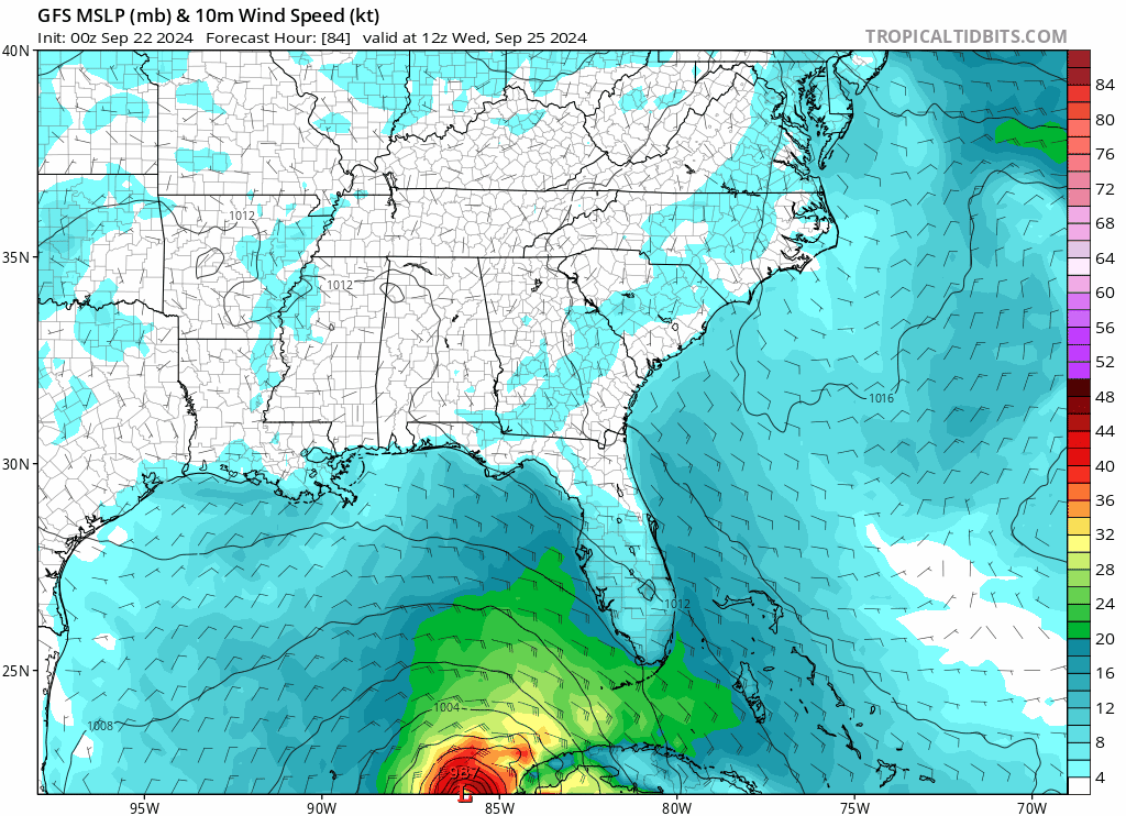
Let's hope this 00Z GFS was a fluke, no bueno for the Tampa Bay area being on the east side of that:
1 likes

Re: Area of low pressure to develop over the western Caribbean sea (0/70)
gatorcane wrote:Let's hope this 00Z GFS was a fluke, no bueno for the Tampa Bay area being on the east side of that:
https://i.postimg.cc/8PfT3MJf/gfs-mslp-wind-seus-fh84-126.gif
Looks like Michael Lite on that run.
1 likes
Irene '11 Sandy '12 Hermine '16 5/15/2018 Derecho Fay '20 Isaias '20 Elsa '21 Henri '21 Ida '21
I am only a meteorology enthusiast who knows a decent amount about tropical cyclones. Look to the professional mets, the NHC, or your local weather office for the best information.
I am only a meteorology enthusiast who knows a decent amount about tropical cyclones. Look to the professional mets, the NHC, or your local weather office for the best information.
Re: Area of low pressure to develop over the western Caribbean sea (0/70)
gatorcane wrote:Let's hope this 00Z GFS was a fluke, no bueno for the Tampa Bay area being on the east side of that:
https://i.postimg.cc/8PfT3MJf/gfs-mslp-wind-seus-fh84-126.gif
This would be catastrophic!
1 likes
Robbielyn McCrary
I know just about enough to sound like I know what I'm talking about sometimes. But for your safety please follow the nhc for truly professional forecasting.
I know just about enough to sound like I know what I'm talking about sometimes. But for your safety please follow the nhc for truly professional forecasting.
-
Ivanhater

- Storm2k Moderator

- Posts: 11222
- Age: 39
- Joined: Fri Jul 01, 2005 8:25 am
- Location: Pensacola
Re: Area of low pressure to develop over the western Caribbean sea (0/70)
06s Gfs into Northwest Florida is because it now has the trough cutting off in line with Euro and Canadian. That's why it shifted west. Let's see if the afternoon models continue with the trough cutting off
0 likes
Michael
-
REDHurricane

- Category 1

- Posts: 438
- Age: 28
- Joined: Sun Jul 03, 2022 2:36 pm
- Location: Northeast Pacific Ocean
Re: Area of low pressure to develop over the western Caribbean sea (0/70)
All three of GFS, Euro, and ICON look nearly identical 48 hours out except for in the EPac -- GFS shows the strongest mid-level vorticity in the NW Caribbean with no consolidated system forming in the EPac, ICON shows a slightly less defined mid-level vorticity but tries to spin up two separate weak storms off the southern coast of Mexico, and ECMWF shows the weakest mid-level vorticity in the Caribbean while it develops a more singular, tightly concentrated system south of Mexico compared to the other two models.
06z GFS +48 hours

06z ICON +48 hours

00z ECMWF +54 hours

Using very simple and probably inexact logic, this tells me that the whatever happens in the EPac south of Mexico could end up affecting the ultimate fate of future Helene (should be 96L but you know whatever), so I think this will be the area to watch closely over the next 2 days or so. A stronger EPac system likely means a weaker Caribbean system and vice versa, which makes sense on its face at least. ICON could be the caveat to this rule, though, as it predicts a much slower developing system at first compared to GFS/ECMWF which I'm guessing would allow the ridging off the SE US coast to strengthen and thus slow down the NE progression of the Caribbean/Gulf system, potentially giving it an extra day or two over water and significantly increasing its top-end potential if the ULAC/trough interaction lines up favorably for rapid intensification. Definitely interesting (and kind of concerning) to see so much variance between the major models just 5-6 days out, but as always it's best to just wait and see how everything progresses today/tomorrow before making any strong conclusions either way.
06z GFS +120 hours

06z ICON +120 hours

06z GFS +48 hours
06z ICON +48 hours
00z ECMWF +54 hours
Using very simple and probably inexact logic, this tells me that the whatever happens in the EPac south of Mexico could end up affecting the ultimate fate of future Helene (should be 96L but you know whatever), so I think this will be the area to watch closely over the next 2 days or so. A stronger EPac system likely means a weaker Caribbean system and vice versa, which makes sense on its face at least. ICON could be the caveat to this rule, though, as it predicts a much slower developing system at first compared to GFS/ECMWF which I'm guessing would allow the ridging off the SE US coast to strengthen and thus slow down the NE progression of the Caribbean/Gulf system, potentially giving it an extra day or two over water and significantly increasing its top-end potential if the ULAC/trough interaction lines up favorably for rapid intensification. Definitely interesting (and kind of concerning) to see so much variance between the major models just 5-6 days out, but as always it's best to just wait and see how everything progresses today/tomorrow before making any strong conclusions either way.
06z GFS +120 hours
06z ICON +120 hours
Last edited by REDHurricane on Sun Sep 22, 2024 6:58 am, edited 3 times in total.
3 likes
-
Blown Away

- S2K Supporter
- Posts: 10253
- Joined: Wed May 26, 2004 6:17 am
Re: Area of low pressure to develop over the western Caribbean sea (10/70)
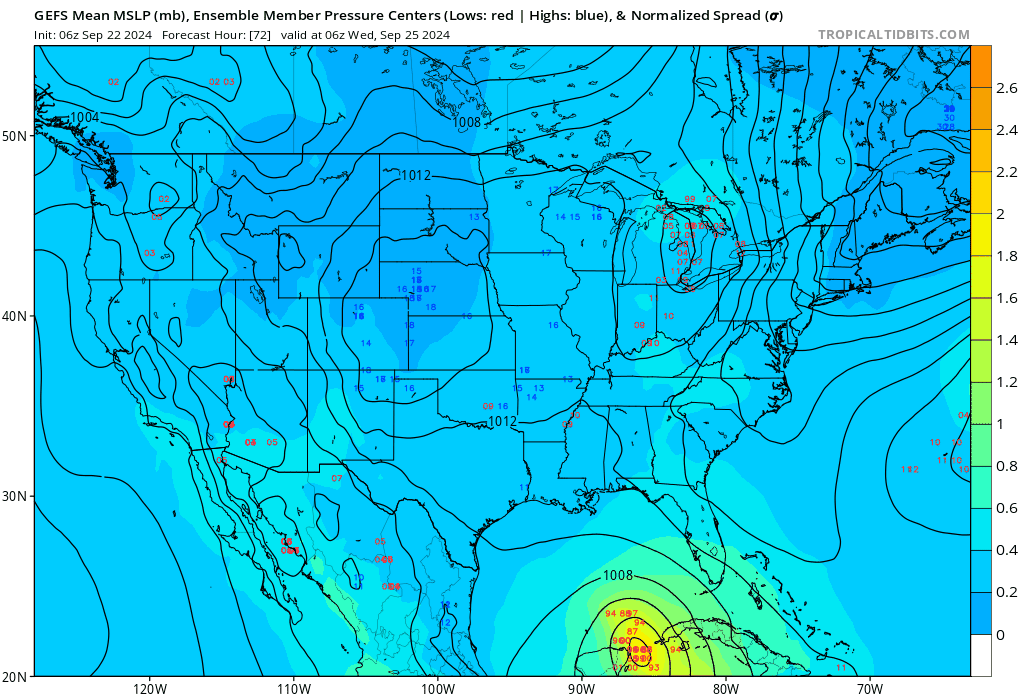
06z GFS ensemble…
2 likes
Hurricane Eye Experience: David 79, Irene 99, Frances 04, Jeanne 04, Wilma 05… Hurricane Brush Experience: Andrew 92, Erin 95, Floyd 99, Matthew 16, Irma 17, Ian 22, Nicole 22…
-
eastcoastFL

- Category 5

- Posts: 3996
- Age: 44
- Joined: Thu Apr 12, 2007 12:29 pm
- Location: Palm City, FL
Re: Area of low pressure to develop over the western Caribbean sea (0/70)
gatorcane wrote:Let's hope this 00Z GFS was a fluke, no bueno for the Tampa Bay area being on the east side of that:
https://i.postimg.cc/8PfT3MJf/gfs-mslp-wind-seus-fh84-126.gif
The only positive take from these runs is the forward speed.
1 likes
Personal Forecast Disclaimer:
The posts in this forum are NOT official forecast and should not be used as such. They are just the opinion of the poster and may or may not be backed by sound meteorological data. They are NOT endorsed by any professional institution or storm2k.org. For official information, please refer to the NHC and NWS products.
The posts in this forum are NOT official forecast and should not be used as such. They are just the opinion of the poster and may or may not be backed by sound meteorological data. They are NOT endorsed by any professional institution or storm2k.org. For official information, please refer to the NHC and NWS products.
-
cycloneye

- Admin

- Posts: 149696
- Age: 69
- Joined: Thu Oct 10, 2002 10:54 am
- Location: San Juan, Puerto Rico
Re: Area of low pressure to develop over the western Caribbean sea (10/70)
The area that I mentioned earlier now has the X.

Northwestern Caribbean Sea and Gulf of Mexico:
Disorganized showers and thunderstorms located over the western
Caribbean Sea and portions of Central America are associated with a
very broad area of low pressure. Environmental conditions appear
favorable for gradual development of this system during the next
several days. A tropical depression is likely to form while the
system moves slowly northward across the northwestern Caribbean Sea
and Gulf of Mexico through the end of the week. Regardless of
development, this system is expected to produce heavy rains over
portions of Central America during the next several days.
* Formation chance through 48 hours...low...10 percent.
* Formation chance through 7 days...high...70 percent.
5 likes
Visit the Caribbean-Central America Weather Thread where you can find at first post web cams,radars
and observations from Caribbean basin members Click Here
and observations from Caribbean basin members Click Here
-
StPeteMike

- Category 2

- Posts: 657
- Joined: Thu Jun 07, 2018 11:26 pm
Re: Area of low pressure to develop over the western Caribbean sea (0/70)
gatorcane wrote:Let's hope this 00Z GFS was a fluke, no bueno for the Tampa Bay area being on the east side of that:
https://i.postimg.cc/8PfT3MJf/gfs-mslp-wind-seus-fh84-126.gif
I was expecting the shift but definitely not the strength! Is it too late to take it back?!?
I’ll take the Euro AI of slopfest storm over this.
1 likes
The above post is not official and should not be used as such. It is the opinion of the poster and may or may not be backed by sound meteorological data. It is not endorsed by any professional institution or storm2k.org. For official information, please refer to the NHC and NWS products.


Re: Area of low pressure to develop over the western Caribbean sea (10/70)
Did they mark the wrong spot...? Looks to me like the vorticity maximum is a little to the south-southeast of Jamaica. What just got marked doesn't have much spin to it. 
0 likes
Re: Area of low pressure to develop over the western Caribbean sea (10/70)
ThomasW wrote:Did they mark the wrong spot...? Looks to me like the vorticity maximum is a little to the south-southeast of Jamaica. What just got marked doesn't have much spin to it.
It does look bad, a bit inland, but this was 3 hours ago

0 likes
-
eastcoastFL
- Category 5
- Posts: 3996
- Age: 44
- Joined: Thu Apr 12, 2007 12:29 pm
- Location: Palm City, FL
Re: Area of low pressure to develop over the western Caribbean sea (10/70)
cycloneye wrote:The area that I mentioned earlier now has the X.
https://i.imgur.com/TF6epjE.pngNorthwestern Caribbean Sea and Gulf of Mexico:
Disorganized showers and thunderstorms located over the western
Caribbean Sea and portions of Central America are associated with a
very broad area of low pressure. Environmental conditions appear
favorable for gradual development of this system during the next
several days. A tropical depression is likely to form while the
system moves slowly northward across the northwestern Caribbean Sea
and Gulf of Mexico through the end of the week. Regardless of
development, this system is expected to produce heavy rains over
portions of Central America during the next several days.
* Formation chance through 48 hours...low...10 percent.
* Formation chance through 7 days...high...70 percent.
Guess we will have an invest pretty soon.
0 likes
Personal Forecast Disclaimer:
The posts in this forum are NOT official forecast and should not be used as such. They are just the opinion of the poster and may or may not be backed by sound meteorological data. They are NOT endorsed by any professional institution or storm2k.org. For official information, please refer to the NHC and NWS products.
The posts in this forum are NOT official forecast and should not be used as such. They are just the opinion of the poster and may or may not be backed by sound meteorological data. They are NOT endorsed by any professional institution or storm2k.org. For official information, please refer to the NHC and NWS products.
Re: Area of low pressure to develop over the western Caribbean sea (10/70)
xironman wrote:ThomasW wrote:Did they mark the wrong spot...? Looks to me like the vorticity maximum is a little to the south-southeast of Jamaica. What just got marked doesn't have much spin to it.
It does look bad, a bit inland, but this was 3 hours ago
https://i.imgur.com/cVl5t14.gif
From what I know, these charts are largely model-based, hence the unrealistically low vorticity on budding Invest 96E. So if the models whiff, these become useless.
1 likes

Re: Area of low pressure to develop over the western Caribbean sea (0/70)
eastcoastFL wrote:GCANE wrote:Massive 700mb gyre centered over Honduras with a strong 500mb vort centered just south of Grand Cayman.
Just as GFS forecasted a few days ago.
Looks like GFS is on par.
Big positive-tilted 250mb trough overhead currently creating shear induced convection.
Any big hot-towers should drive the mid-level vorts to the surface in the next couple days.
GFS has the LL vort entering the GoM thru the Yucatan Channel.
Will be ahead of the tail of a Rossby Wave then.
At that point need to see if an anti-cyclone develops overhead or if gets caught up in the RW's UL flow and gets sheared.
Hey G, is that slop moving around the W. Carib the ingredients to our future storm? Is that expected to move into the AOI published by the NHC?
A lot of vorticity in the mid-levels.
Need some high-helicity hot towers to push it down to the surface of the water.
What fuels that? Tons of unstable air, in terms of high CAPE & TPW air, coming in from the EPAC across Nicaragua and Panama due to the 700mb Gyre.
I am thinking afternoon popup storms from Honduras and Nicaragua will move into the Carib and set it off early morning Monday and develop thru Tuesday,
1 likes
Re: Area of low pressure to develop over the western Caribbean sea (0/70)
jlauderdal wrote:3090 wrote:Stormlover70 wrote:getting concerned here in Pasco County.
And folks between Pensacola and Biloxi should equally be concerned if they follow the EURO members. So now, which model is going to be more accurate?
We can't discount the Euro completely, but what we do know is that it had a westerly solution and now has moved significantly to the east, playing catch up with the other guidance. Watch the trends and it has been significantly east the last 24 hours. Apalachicola to Sarasota, I moved my goal posts in on the east and west sides.
EURO has most members between Biloxi and Pensacola even with it trending east the past two days.
0 likes
-
Hypercane_Kyle

- Category 5
- Posts: 3465
- Joined: Sat Mar 07, 2015 7:58 pm
- Location: Cape Canaveral, FL
Re: Area of low pressure to develop over the western Caribbean sea (10/70)
Looking like this one will take a similar path to Michael, Idalia and Debby. A lot will change once that LLC develops. Expect to be tagged as an invest in the next 24 hours.
1 likes
My posts are my own personal opinion, defer to the National Hurricane Center (NHC) and other NOAA products for decision making during hurricane season.
Re: Area of low pressure to develop over the western Caribbean sea (10/70)
ThomasW wrote:xironman wrote:ThomasW wrote:Did they mark the wrong spot...? Looks to me like the vorticity maximum is a little to the south-southeast of Jamaica. What just got marked doesn't have much spin to it.
It does look bad, a bit inland, but this was 3 hours ago
https://i.imgur.com/cVl5t14.gif
From what I know, these charts are largely model-based, hence the unrealistically low vorticity on budding Invest 96E. So if the models whiff, these become useless.
The product is based on satellite, the model is just the background structure where there is insufficient cloud data. There are currently lots of clouds there.
Atmospheric Motion Vector (AMV) Gridded Analysis
Background: Analyses are calculated utilizing gridded output from the auto editing process of the satellite atmospheric motion vector (AMV) fields. The AMV data are fit to a one degree grid at the following heights (100, 150, 200, 250, 300, 350, 400, 500, 600, 700, 775, 850, and 925 hPa), with data sparse regions at each height filled with numerical model output. Grids consist of u and v wind components.
The background model used is United States NOAA's GFS model.
More info on AMV https://tropic.ssec.wisc.edu/misc/winds ... ds.ir.html
Atmospheric Motion Vectors are derived using a sequence of three images. Features are targeted in the second image (cirrus cloud edges, gradients in water vapor, small cumulus clouds, etc.) are tracked within the first and third images yielding two displacement vectors. These vectors are averaged to derive the final wind vector.
Vector heights are assigned in a two-step process. The first utilizes the measured radiances of the target and is based on the spectral response function of the individual satellite and channel being sampled. The brightness temperature of the target is derived from this radiance measurement. Once determined, the brightness temperature is compared with a collocated numerical model guess temperature profile, from which an initial height is estimated. The final vector height is derived in the post-processing of the vector field.
Vector heights are assigned in a two-step process. The first utilizes the measured radiances of the target and is based on the spectral response function of the individual satellite and channel being sampled. The brightness temperature of the target is derived from this radiance measurement. Once determined, the brightness temperature is compared with a collocated numerical model guess temperature profile, from which an initial height is estimated. The final vector height is derived in the post-processing of the vector field.
Last edited by xironman on Sun Sep 22, 2024 7:37 am, edited 1 time in total.
2 likes
Who is online
Users browsing this forum: Google Adsense [Bot], Old-TimeCane and 165 guests