Low pressure developing over the western Caribbean Sea (Is Invest 97L)
Moderator: S2k Moderators
Forum rules

The posts in this forum are NOT official forecasts and should not be used as such. They are just the opinion of the poster and may or may not be backed by sound meteorological data. They are NOT endorsed by any professional institution or STORM2K. For official information, please refer to products from the National Hurricane Center and National Weather Service.
-
ThunderForce

- Tropical Storm

- Posts: 208
- Age: 26
- Joined: Tue Sep 27, 2022 6:20 pm
- Location: Calhoun County, Florida
Re: Low pressure developing over the western Caribbean Sea (10/70)
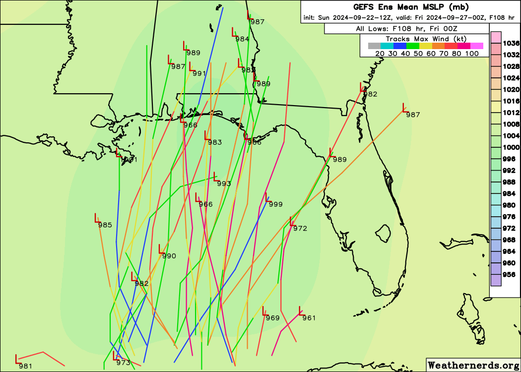
12z GEFS ensembles from Weathernerds:
1 likes
Please refer to the NWS, NHC, SPC or a professional meteorologist for information and decision making during storms.
-
Sciencerocks
- Category 5

- Posts: 10181
- Age: 40
- Joined: Thu Jul 06, 2017 1:51 am
Re: Low pressure developing over the western Caribbean Sea (10/70)
Reminds me somewhat of Michael 2018 as it is developing in a similar area with a similar track with some of the models do in fact hint at it(gfs, ecmwf, etc), but I also believe another 1921 hurricane also looks possible based on the eastern possibilities within the models. SO track is between Michael 2018 and 1921. I don't think as strong as Michael but possibly cat2-3 range.
Last edited by Sciencerocks on Sun Sep 22, 2024 12:18 pm, edited 1 time in total.
2 likes


Re: Low pressure developing over the western Caribbean Sea (10/70)
hipshot wrote:Steve wrote:hipshot wrote:So how/what makes this different in the way it will effect a storm?
Thks
Hey hip. In the case of Francine you had a developing low coming up from the BOC with a trough across most of Texas. Like 57 said It was textbook that the center would continue to develop to the right as it repeatedly consolidated with the energy ahead of it. It probably eventually split but was a v shaped trough so the flow ahead of it is out of the SW. That’s still the same but when the point cuts off you have counter-clockwise rotating energy within the trough and in this case the strongest part of the trough. It buckles and the flow, again counterclockwise is going to draw in the energy from the surface tropics circulation.
A trough is an area of low pressure correct so... the cut off low becomes stronger when when it is basically broken up or disturbed by
some other weather pattern?
In the case of most other models yeah. Press play on the CMC icon and Nam below and watch the interaction. This is at 500mb so roughly 18,000 feet/3.41 miles.
Icon
https://www.tropicaltidbits.com/analysi ... 92212&fh=6
CMC
https://www.tropicaltidbits.com/analysi ... 212&fh=150
Nam
https://www.tropicaltidbits.com/analysi ... 212&fh=-36
0 likes
-
Hypercane_Kyle

- Category 5
- Posts: 3465
- Joined: Sat Mar 07, 2015 7:58 pm
- Location: Cape Canaveral, FL
Re: Low pressure developing over the western Caribbean Sea (10/70)
That 12z GFS run is absolutely horrifying. For that to happen we'd need to have a TS by tomorrow though.
Not sure that will happen based on current organization.

Not sure that will happen based on current organization.
1 likes
My posts are my own personal opinion, defer to the National Hurricane Center (NHC) and other NOAA products for decision making during hurricane season.
Re: Low pressure developing over the western Caribbean Sea (10/70)
hipshot wrote:Steve wrote:hipshot wrote:So how/what makes this different in the way it will effect a storm?
Thks
Hey hip. In the case of Francine you had a developing low coming up from the BOC with a trough across most of Texas. Like 57 said It was textbook that the center would continue to develop to the right as it repeatedly consolidated with the energy ahead of it. It probably eventually split but was a v shaped trough so the flow ahead of it is out of the SW. That’s still the same but when the point cuts off you have counter-clockwise rotating energy within the trough and in this case the strongest part of the trough. It buckles and the flow, again counterclockwise is going to draw in the energy from the surface tropics circulation.
A trough is an area of low pressure correct so... the cut off low becomes stronger when when it is basically broken up or disturbed by
some other weather pattern?
I’m watching football so neglected to mention that troughs in La Niña patterns tend to be more fluid and split off at their apex. In El Niños they generally are progressive and move west to east across the country. This is a general rule and not 100%.
0 likes
-
TomballEd
- Category 5
- Posts: 1260
- Age: 62
- Joined: Wed Aug 16, 2023 4:52 pm
- Location: Spring/Klein area, not Tomball
Re: Low pressure developing over the western Caribbean Sea (10/70)
One of the things Berger doesn't like is that this isn't 97L yet. I know Dr. Andy Hazelton cautions about the models he helped develop, the HAFS models, not being as useful without a defined existing center, but Berger seems to think they'd be useful. I think using remote sensing and putting a low in at the area of greatest low level vorticity would at least help somewhat on the intensity side.
0 likes
-
StPeteMike

- Category 2

- Posts: 653
- Joined: Thu Jun 07, 2018 11:26 pm
Re: Low pressure developing over the western Caribbean Sea (10/70)
Hoping the Happy Hour run doesn’t play any games if they designate this as an invest at 2 pm.
1 likes
The above post is not official and should not be used as such. It is the opinion of the poster and may or may not be backed by sound meteorological data. It is not endorsed by any professional institution or storm2k.org. For official information, please refer to the NHC and NWS products.
Re: Low pressure developing over the western Caribbean Sea (10/70)
EC 12z is loading on pivotal but early.
0 likes
-
ConvergenceZone
.gif)
- Category 5
- Posts: 5241
- Joined: Fri Jul 29, 2005 1:40 am
- Location: Northern California
Re: Low pressure developing over the western Caribbean Sea (10/70)
As someone pointed out earlier is that this system will be moving at an absolute lightning speed. While that's bad for preparation, it should be over just a few short hours after it begins, thus a short duration event. Also, will have much less time to get really strong.
0 likes
-
Sciencerocks
- Category 5
- Posts: 10181
- Age: 40
- Joined: Thu Jul 06, 2017 1:51 am
-
Pipelines182
- Tropical Storm
- Posts: 159
- Joined: Tue Jul 02, 2024 8:46 am
Re: Low pressure developing over the western Caribbean Sea (10/70)
Hypercane_Kyle wrote:That 12z GFS run is absolutely horrifying. For that to happen we'd need to have a TS by tomorrow though.
Not sure that will happen based on current organization.
https://i.imgur.com/HRYczM0.jpeg
Not really, we’ve seen numerous systems intensify from TS to C5 in 48 hours, I believe Michael did it in around 54. It only needs to be a TS by 00z Wednesday.
0 likes
-
TomballEd
- Category 5
- Posts: 1260
- Age: 62
- Joined: Wed Aug 16, 2023 4:52 pm
- Location: Spring/Klein area, not Tomball
Re: Low pressure developing over the western Caribbean Sea (10/70)
Steve wrote:EC 12z is loading on pivotal but early.
The 6Z ECENS are pretty focused, most members into the Panhandle. There is more spread on the GEFS, if I could see a mean, I'd guess the Panhandle as well. Be interesting to see if Euro catches up a little on intensity. Like the UK Met, it tends to downplay intensity, nowhere near as bad as the UK model, but it still seems to downplay intensity.
Berger mentioned in his Space City Weather post that despite the increasing shear and dry air E of the center as it approaches the coast, the warmer than normal temperatures will hold off dry air into the core. GFS and 6Z Euro show less shear than earlier model predictions, I suspect because the storm is strong enough to pump up enough of an anticyclone above it to help protect it from shear.
0 likes
Re: Low pressure developing over the western Caribbean Sea (10/70)
ConvergenceZone wrote:As someone pointed out earlier is that this system will be moving at an absolute lightning speed. While that's bad for preparation, it should be over just a few short hours after it begins, thus a short duration event. Also, will have much less time to get really strong.
Can you define "lightning speed"...I'm not seeing that. I do see plenty of solutions...some of which are very strong. If a system organizes it can intensify very rapidly if the stars align. OHC in the Gulf and Caribbean is record highs for this date per McNoldy's data. Otis went from a cat 1 to a 5 in 12 hours last year with similar rocket fuel. Explosive development should be a consideration even if that outcome isn't most likely.
1 likes

Re: Low pressure developing over the western Caribbean Sea (10/70)
Just offshore NicHon Border.
Convection regenerating.
Convection regenerating.
4 likes
Re: Low pressure developing over the western Caribbean Sea (10/70)
102 hour EC says GFS needs to take a break with that Cat 4 BS and joins the other models
https://www.pivotalweather.com/model.ph ... &dpdt=&mc=
GFS is the outlier rightfully or wrongfully.
https://www.pivotalweather.com/model.ph ... &dpdt=&mc=
GFS is the outlier rightfully or wrongfully.
0 likes
-
Argcane
- Tropical Low

- Posts: 24
- Age: 25
- Joined: Wed Aug 19, 2020 12:52 pm
- Location: Patagonia/Argentina
Re: Low pressure developing over the western Caribbean Sea (10/70)
GCANE wrote:Just offshore NicHon Border.
Convection regenerating.
1 likes
Re: Low pressure developing over the western Caribbean Sea (40/80)
Northwestern Caribbean Sea and Gulf of Mexico:
Disorganized showers and thunderstorms located over the northwestern
Caribbean Sea and portions of Central America are associated with a
broad area of low pressure. Environmental conditions appear
favorable for development of this system, and a tropical depression
or tropical storm is likely to form during the next few days while
moving northward across the northwestern Caribbean Sea and Gulf of
Mexico. Regardless of development, this disturbance is expected to
produce heavy rains over portions of Central America during the next
several days. Interests in the northwestern Caribbean, Yucatan
Peninsula of Mexico, and western Cuba should closely monitor the
progress of this feature. Later this week, the system is forecast to
move generally northward across the Gulf of Mexico, and interests
along the northern and northeastern Gulf Coast should also monitor
the progress of this system.
* Formation chance through 48 hours...medium...40 percent.
* Formation chance through 7 days...high...80 percent.
0 likes
-
ConvergenceZone
- Category 5
- Posts: 5241
- Joined: Fri Jul 29, 2005 1:40 am
- Location: Northern California
Re: Low pressure developing over the western Caribbean Sea (10/70)
Pipelines182 wrote:Hypercane_Kyle wrote:That 12z GFS run is absolutely horrifying. For that to happen we'd need to have a TS by tomorrow though.
Not sure that will happen based on current organization.
https://i.imgur.com/HRYczM0.jpeg
Not really, we’ve seen numerous systems intensify from TS to C5 in 48 hours, I believe Michael did it in around 54. It only needs to be a TS by 00z Wednesday.
True, but that was only because the atmospheric conditions were nearly "perfect" and that rarely happens.
0 likes
Re: Low pressure developing over the western Caribbean Sea (40/80)
They went from 10 to 40 for 48 hour development odds. For an agency that likes to step a dime at a time...stacking 3 in one forecast cycle tells a lot.
2 likes
-
Category5Kaiju

- Category 5
- Posts: 4330
- Joined: Thu Dec 24, 2020 12:45 pm
- Location: Seattle and Phoenix
Re: Low pressure developing over the western Caribbean Sea (40/80)
I think the fact that some model runs have this thing developing into a named storm as early as tomorrow explains the massive, seemingly abrupt increase in development odds.
5 likes
Unless explicitly stated, all info in my posts is based on my own opinions and observations. Tropical storms and hurricanes can be extremely dangerous. Refer to an accredited weather research agency or meteorologist if you need to make serious decisions regarding an approaching storm.
Who is online
Users browsing this forum: No registered users and 88 guests