ATL: HELENE - Models
Moderator: S2k Moderators

-
cycloneye

- Admin

- Posts: 149682
- Age: 69
- Joined: Thu Oct 10, 2002 10:54 am
- Location: San Juan, Puerto Rico
Re: ATL: INVEST 97L - Models

1 likes
Visit the Caribbean-Central America Weather Thread where you can find at first post web cams,radars
and observations from Caribbean basin members Click Here
and observations from Caribbean basin members Click Here

Re: ATL: INVEST 97L - Models
It looks like every single 12z EPS member has development in some capacity? Most members are hurricanes and about 10-15% get down to the 960s. Tightest clustering is around the big bend region.
3 likes
Kendall -> SLO -> PBC
Memorable Storms: Katrina (for its Florida landfall...) Wilma Matthew Irma
Memorable Storms: Katrina (for its Florida landfall...) Wilma Matthew Irma
-
Category5Kaiju

- Category 5

- Posts: 4345
- Joined: Thu Dec 24, 2020 12:45 pm
- Location: Seattle during the summer, Phoenix during the winter
ATL: INVEST 97L - Discussion
Get ready for the hurricane models 
6 likes
Unless explicitly stated, all information in my posts is based on my own opinions and observations. Tropical storms and hurricanes can be extremely dangerous. Refer to an accredited weather research agency or meteorologist if you need to make serious decisions regarding an approaching storm.
-
ThunderForce

- Tropical Storm

- Posts: 208
- Age: 26
- Joined: Tue Sep 27, 2022 6:20 pm
- Location: Calhoun County, Florida
Re: ATL: INVEST 97L - Models
I'm curious about something. Is the track pretty much a "lock" at this point? It seems like all of the operational models are now showing this hitting either Bay County or Gulf County, and landfall seems to be only 4-5 days away.
0 likes
Please refer to the NWS, NHC, SPC or a professional meteorologist for information and decision making during storms.
-
chris_fit

- Category 5
- Posts: 3261
- Age: 43
- Joined: Wed Sep 10, 2003 11:58 pm
- Location: Tampa Bay Area, FL
Re: ATL: INVEST 97L - Models
ThunderForce wrote:I'm curious about something. Is the track pretty much a "lock" at this point? It seems like all of the operational models are now showing this hitting either Bay County or Gulf County, and landfall seems to be only 4-5 days away.
Far from a lock. Center needs to be established first.
3 likes
-
CrazyC83
- Professional-Met

- Posts: 34316
- Joined: Tue Mar 07, 2006 11:57 pm
- Location: Deep South, for the first time!
Re: ATL: INVEST 97L - Models
Time is not our friend either - I'd be getting the G-IV into the Gulf tomorrow as well. As it is, a Hurricane Watch will likely be needed somewhere on the Gulf Coast by late Tuesday based on projections...additionally, I think more balloon launches are needed, since we need to know the strength of the trough and the orientation.
Last edited by CrazyC83 on Sun Sep 22, 2024 3:21 pm, edited 1 time in total.
4 likes
-
redingtonbeach
- Tropical Depression

- Posts: 65
- Joined: Mon Sep 04, 2017 12:05 am
Re: ATL: INVEST 97L - Models
cycloneye wrote:https://i.imgur.com/TSkzLMG.jpeg
If I’m reading this right, the SHIPS model is projecting a low-end Cat 3 at landfall. Is that accurate?
0 likes
-
DunedinDave
- Category 1

- Posts: 269
- Joined: Fri Aug 25, 2023 10:31 am
Re: ATL: INVEST 97L - Models
ThunderForce wrote:I'm curious about something. Is the track pretty much a "lock" at this point? It seems like all of the operational models are now showing this hitting either Bay County or Gulf County, and landfall seems to be only 4-5 days away.
That's a good question because I was on this morning and there were several board members on here basically saying Appalachicola to Biloxi is a lock. Kind of made me drop my guard here a bit in the TB area since I figure they know a lot more than I do but I'd be curious if this track seems pretty set?
0 likes
Re: ATL: INVEST 97L - Models
chris_fit wrote:ThunderForce wrote:I'm curious about something. Is the track pretty much a "lock" at this point? It seems like all of the operational models are now showing this hitting either Bay County or Gulf County, and landfall seems to be only 4-5 days away.
Far from a lock. Center needs to be established first.
Definitely not a “lock”, but the window for windshield wiping is closing quickly. Models are, as of this morning, zeroing in on the area from Destin to Apalachicola. This is subject to change, however.
0 likes
-
StPeteMike

- Category 2

- Posts: 657
- Joined: Thu Jun 07, 2018 11:26 pm
Re: ATL: INVEST 97L - Models
DunedinDave wrote:ThunderForce wrote:I'm curious about something. Is the track pretty much a "lock" at this point? It seems like all of the operational models are now showing this hitting either Bay County or Gulf County, and landfall seems to be only 4-5 days away.
That's a good question because I was on this morning and there were several board members on here basically saying Appalachicola to Biloxi is a lock. Kind of made me drop my guard here a bit in the TB area since I figure they know a lot more than I do but I'd be curious if this track seems pretty set?
Nothing is locked yet. I would let the models digest all the new information they have now with a fixed point and check the 0z model and much of tomorrow. Anything from a cenger reformation to a little jug to the east or west could put new areas at risk.
3 likes
The above post is not official and should not be used as such. It is the opinion of the poster and may or may not be backed by sound meteorological data. It is not endorsed by any professional institution or storm2k.org. For official information, please refer to the NHC and NWS products.
-
gatorcane

- S2K Supporter

- Posts: 23708
- Age: 48
- Joined: Sun Mar 13, 2005 3:54 pm
- Location: Boca Raton, FL
Re: ATL: INVEST 97L - Models
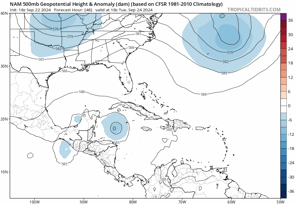
The NAM is not a tropical model but it is reasonably good at forecasting large-scale features and 500MB steering. Interesting that it's the first run in the last few runs where it shows the cut-off low more east over Arkansas. In the 12Z it was over eastern Oklahoma, are the models getting any special data fed into them in this 18Z cycle?
3 likes
-
StPeteMike
- Category 2
- Posts: 657
- Joined: Thu Jun 07, 2018 11:26 pm
Re: ATL: INVEST 97L - Models
gatorcane wrote:The NAM is not a tropical model but it is reasonably good at forecasting large-scale features and 500MB steering. Interesting that it's the first run in the last few runs where it shows the cut-off low more east over Arkansas. In the 12Z it was over eastern Oklahoma, are the models getting some data fed into them in this 18Z cycle?
https://i.postimg.cc/yY1LB3nX/nam-z500a-watl-fh48-84.gif
Not good for the Tampa Bay region if that is the case.
0 likes
The above post is not official and should not be used as such. It is the opinion of the poster and may or may not be backed by sound meteorological data. It is not endorsed by any professional institution or storm2k.org. For official information, please refer to the NHC and NWS products.
-
DunedinDave
- Category 1
- Posts: 269
- Joined: Fri Aug 25, 2023 10:31 am
Re: ATL: INVEST 97L - Models
Curious for those who remember…what were the factors that pushed Ian so hard to the right? Was it a trough like the one forecast to come down into the SE? If so where was that positioned?
0 likes

Re: ATL: INVEST 97L - Models
[quote="DunedinDave"]Curious for those who remember…what were the factors that pushed Ian so hard to the right? Was it a trough like the one forecast to come down into the SE? If so where was that positioned?[/]
Last edited by robbielyn on Sun Sep 22, 2024 4:26 pm, edited 2 times in total.
0 likes
Robbielyn McCrary
I know just about enough to sound like I know what I'm talking about sometimes. But for your safety please follow the nhc for truly professional forecasting.
I know just about enough to sound like I know what I'm talking about sometimes. But for your safety please follow the nhc for truly professional forecasting.
-
Weathertracker96
- Tropical Storm
- Posts: 150
- Joined: Mon Oct 16, 2023 3:41 pm
-
gatorcane
- S2K Supporter
- Posts: 23708
- Age: 48
- Joined: Sun Mar 13, 2005 3:54 pm
- Location: Boca Raton, FL
Re: ATL: INVEST 97L - Models
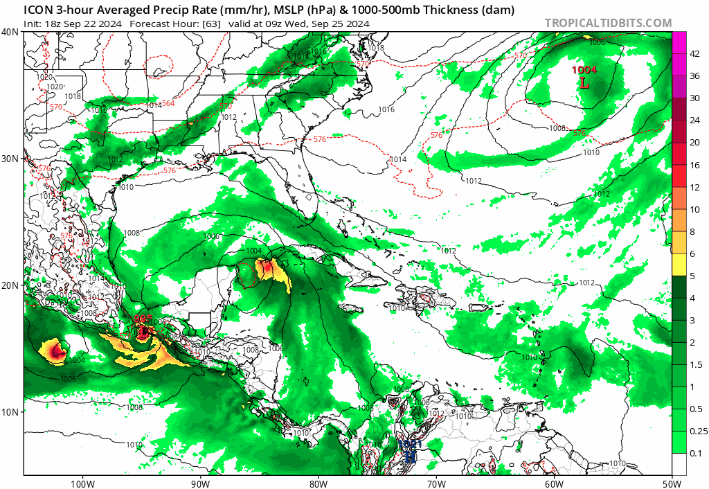
18Z ICON with some NE movement across the EGOM:
Last edited by gatorcane on Sun Sep 22, 2024 4:25 pm, edited 2 times in total.
0 likes
-
jlauderdal
- S2K Supporter
- Posts: 7240
- Joined: Wed May 19, 2004 5:46 am
- Location: NE Fort Lauderdale
- Contact:
Re: ATL: INVEST 97L - Models
Icon sniffed out ian movement.gatorcane wrote:18Z ICON with NE movement across the EGOM now:
2 likes
-
eastcoastFL

- Category 5
- Posts: 3996
- Age: 44
- Joined: Thu Apr 12, 2007 12:29 pm
- Location: Palm City, FL
Re: ATL: INVEST 97L - Models
ThunderForce wrote:I'm curious about something. Is the track pretty much a "lock" at this point? It seems like all of the operational models are now showing this hitting either Bay County or Gulf County, and landfall seems to be only 4-5 days away.
No such thing as a lock in the tropics. This isn't a simple set up and it will come down to timing. Once we get a defined center and the flights start sampling the air we will have a much better idea from the models.
2 likes
Personal Forecast Disclaimer:
The posts in this forum are NOT official forecast and should not be used as such. They are just the opinion of the poster and may or may not be backed by sound meteorological data. They are NOT endorsed by any professional institution or storm2k.org. For official information, please refer to the NHC and NWS products.
The posts in this forum are NOT official forecast and should not be used as such. They are just the opinion of the poster and may or may not be backed by sound meteorological data. They are NOT endorsed by any professional institution or storm2k.org. For official information, please refer to the NHC and NWS products.
-
DunedinDave
- Category 1
- Posts: 269
- Joined: Fri Aug 25, 2023 10:31 am
Re: ATL: INVEST 97L - Models
That 18z ICON track is almost a carbon copy of Hurricane Idalia. I mean if you put the two on top of each other you would barely notice a difference.
0 likes
Who is online
Users browsing this forum: No registered users and 80 guests