ATL: HELENE - Models
Moderator: S2k Moderators
-
lsuhurricane
- Category 1

- Posts: 270
- Joined: Tue Aug 15, 2017 2:53 pm


Re: ATL: NINE - Models
SouthFLTropics wrote:DunedinDave wrote:18z ICON with a shift east. Hard to tell but it appears landfall north of Pasco county. Hard to tell. Looks like between Spring Hill and Crystal River.
That’s a significant shift East. Not as noticeable at landfall as it is once it gets into Georgia.
Sent from my iPhone using Tapatalk
Worst case scenario for Tampa Bay metro.
1 likes
-
tolakram
- Admin

- Posts: 20186
- Age: 62
- Joined: Sun Aug 27, 2006 8:23 pm
- Location: Florence, KY (name is Mark)
Re: ATL: NINE - Models
The one model you don't want to see shift east. Will the Icon accuracy streak continue?
7 likes
M a r k
- - - - -
Join us in chat: Storm2K Chatroom Invite. Android and IOS apps also available.
The posts in this forum are NOT official forecasts and should not be used as such. Posts are NOT endorsed by any professional institution or STORM2K.org. For official information and forecasts, please refer to NHC and NWS products.
-
ConvergenceZone
.gif)
- Category 5

- Posts: 5241
- Joined: Fri Jul 29, 2005 1:40 am
- Location: Northern California
Re: ATL: NINE - Models
Let's hope that ICON run isn't starting a trend, or else bye bye Tampa. Luckily it's just one model run.
1 likes
-
SouthFLTropics

- Category 5
- Posts: 4258
- Age: 50
- Joined: Thu Aug 14, 2003 8:04 am
- Location: Port St. Lucie, Florida
Re: ATL: NINE - Models
ronjon wrote:SouthFLTropics wrote:DunedinDave wrote:18z ICON with a shift east. Hard to tell but it appears landfall north of Pasco county. Hard to tell. Looks like between Spring Hill and Crystal River.
That’s a significant shift East. Not as noticeable at landfall as it is once it gets into Georgia.
Sent from my iPhone using Tapatalk
Worst case scenario for Tampa Bay metro.
Absolutely…one of the NHC’s biggest fears has always been a major making landfall just north of Tampa Bay. The entire region around the bay will be inundated.
Sent from my iPhone using Tapatalk
3 likes
Fourth Generation Florida Native
Personal Storm History: David 79, Andrew 92, Erin 95, Floyd 99, Irene 99, Frances 04, Jeanne 04, Wilma 05, Matthew 16, Irma 17, Ian 22, Nicole 22, Milton 24
Personal Storm History: David 79, Andrew 92, Erin 95, Floyd 99, Irene 99, Frances 04, Jeanne 04, Wilma 05, Matthew 16, Irma 17, Ian 22, Nicole 22, Milton 24
-
ConvergenceZone
- Category 5
- Posts: 5241
- Joined: Fri Jul 29, 2005 1:40 am
- Location: Northern California
Re: ATL: NINE - Models
tolakram wrote:The one model you don't want to see shift east. Will the Icon accuracy streak continue?
Yea I was thinking the same thing. It will be interesting to see if we see any shifts with GFS and EURO later.
1 likes
-
jlauderdal
- S2K Supporter

- Posts: 7240
- Joined: Wed May 19, 2004 5:46 am
- Location: NE Fort Lauderdale
- Contact:
Re: ATL: NINE - Models
Blown Away wrote:[url]https://i.postimg.cc/fbnVx9mr/icon-mslp-wind-seus-fh48-90.gif [/url]
18z Icon… Decent shift S to just N of Tampa…
PTSD from Ian and I am on the other side of the state.
2 likes
-
DunedinDave
- Category 1
- Posts: 269
- Joined: Fri Aug 25, 2023 10:31 am
Re: ATL: NINE - Models
If there’s any good news the ICON is racing and has it around cat 2 level.
3 likes

-
jlauderdal
- S2K Supporter
- Posts: 7240
- Joined: Wed May 19, 2004 5:46 am
- Location: NE Fort Lauderdale
- Contact:
Re: ATL: NINE - Models
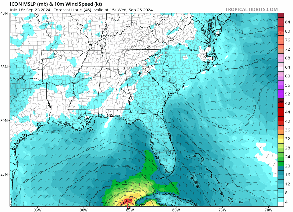
gatorcane wrote:Saved 18Z ICON, hope it is not the start of a trend:
https://i.postimg.cc/nLWCwtjv/icon-mslp-wind-seus-fh45-84.gif
Hasn't the trend been east for over a day with the exception of an occasional windshield wiper?
0 likes
Re: ATL: NINE - Models
ConvergenceZone wrote:tolakram wrote:The one model you don't want to see shift east. Will the Icon accuracy streak continue?
Yea I was thinking the same thing. It will be interesting to see if we see any shifts with GFS and EURO later.
I may be staying up late for 00z model suite. Let's hope it's just a one off run from the ICON.
0 likes

Re: ATL: NINE - Models
SouthFLTropics wrote:DunedinDave wrote:18z ICON with a shift east. Hard to tell but it appears landfall north of Pasco county. Hard to tell. Looks like between Spring Hill and Crystal River.
That’s a significant shift East. Not as noticeable at landfall as it is once it gets into Georgia.
Sent from my iPhone using Tapatalk
ICON seems to want to continue the trek NE, instead of looping back over Georgia and Tennessee headed NW.
0 likes
Personal Forecast Disclaimer:
The posts in this forum are NOT official forecast and should not be used as such. They are just the opinion of the poster and may or may not be backed by sound meteorological data. They are NOT endorsed by any professional institution or storm2k.org. For official information, please refer to the NHC and NWS products.
The posts in this forum are NOT official forecast and should not be used as such. They are just the opinion of the poster and may or may not be backed by sound meteorological data. They are NOT endorsed by any professional institution or storm2k.org. For official information, please refer to the NHC and NWS products.

-
ConvergenceZone
- Category 5
- Posts: 5241
- Joined: Fri Jul 29, 2005 1:40 am
- Location: Northern California
Re: ATL: NINE - Models
DunedinDave wrote:If there’s any good news the ICON is racing and has it around cat 2 level.
A cat 2 IF it were to hit Tampa can still be devastating.
1 likes

Re: ATL: NINE - Models
SoupBone wrote:SouthFLTropics wrote:DunedinDave wrote:18z ICON with a shift east. Hard to tell but it appears landfall north of Pasco county. Hard to tell. Looks like between Spring Hill and Crystal River.
That’s a significant shift East. Not as noticeable at landfall as it is once it gets into Georgia.
Sent from my iPhone using Tapatalk
ICON seems to want to continue the trek NE, instead of looping back over Georgia and Tennessee headed NW.
Looks like the trough gets a little further east before getting cut off. Would reduce the tugging to the west which makes sense
4 likes
-
DunedinDave
- Category 1
- Posts: 269
- Joined: Fri Aug 25, 2023 10:31 am
Re: ATL: NINE - Models
jfk08c wrote:SoupBone wrote:SouthFLTropics wrote:That’s a significant shift East. Not as noticeable at landfall as it is once it gets into Georgia.
Sent from my iPhone using Tapatalk
ICON seems to want to continue the trek NE, instead of looping back over Georgia and Tennessee headed NW.
Looks like the trough gets a little further east before getting cut off. Would reduce the tugging to the west which makes sense
What's scary is if the Euro and GFS also forecast that trough moving more east, then they also are going to shift their track right. Kinda nervous about these 18z models.
1 likes
-
chris_fit

- Category 5
- Posts: 3261
- Age: 43
- Joined: Wed Sep 10, 2003 11:58 pm
- Location: Tampa Bay Area, FL
Re: ATL: NINE - Models
ConvergenceZone wrote:DunedinDave wrote:If there’s any good news the ICON is racing and has it around cat 2 level.
A cat 2 IF it were to hit Tampa can still be devastating.
Debby was devastating. More than so than Irma and Ian at least here in Parrish... Just south of Tampa.
0 likes
-
StPeteMike

- Category 2

- Posts: 657
- Joined: Thu Jun 07, 2018 11:26 pm
Re: ATL: NINE - Models
jfk08c wrote:SoupBone wrote:SouthFLTropics wrote:That’s a significant shift East. Not as noticeable at landfall as it is once it gets into Georgia.
Sent from my iPhone using Tapatalk
ICON seems to want to continue the trek NE, instead of looping back over Georgia and Tennessee headed NW.
Looks like the trough gets a little further east before getting cut off. Would reduce the tugging to the west which makes sense
Unfortunately, exactly what I was expecting. The models do a lot, but boy have I see them underperform on incoming troughs. Unsure if the Euro will cave but I can see the GFS aligning with the ICON.
1 likes
The above post is not official and should not be used as such. It is the opinion of the poster and may or may not be backed by sound meteorological data. It is not endorsed by any professional institution or storm2k.org. For official information, please refer to the NHC and NWS products.
Re: ATL: NINE - Models
18z GFS now running on TT. I haven't been this nervous anticipating a model run since IAN. 
2 likes
Who is online
Users browsing this forum: No registered users and 76 guests