ATL: HELENE - Post-Tropical - Discussion

Moderator: S2k Moderators

Message
Author
User avatar
eastcoastFL
Category 5
Category 5
Posts: 3901
Age: 43
Joined: Thu Apr 12, 2007 12:29 pm
Location: Palm City, FL

Re: ATL: NINE - Potential Tropical Cyclone - Discussion

#601 Postby eastcoastFL » Mon Sep 23, 2024 8:42 pm

Steve wrote:
StPeteMike wrote:
3090 wrote:I doubt it. ULL is still ripping. Still going to be some time. Let the ULL do its thing as long as possible. But hearing this sentiment for the past 24 hours sooner or later it will happen. Probably some time tomorrow.

Sorry, the satellite image is not of a storm being ripped.


Its influence is waning as it pulls west. Gonna result in OG pattern reversal though which is why it is likely to ramp unless there are land interactions.

https://www.tropicaltidbits.com/sat/sat ... uct=wv_mid


Oh ya, that is a pretty good look at it. Probably won't be much of a factor come morning. Even less if the center is actually reforming further east.
1 likes   
Personal Forecast Disclaimer:
The posts in this forum are NOT official forecast and should not be used as such. They are just the opinion of the poster and may or may not be backed by sound meteorological data. They are NOT endorsed by any professional institution or storm2k.org. For official information, please refer to the NHC and NWS products.

rigbyrigz
S2K Supporter
S2K Supporter
Posts: 125
Joined: Thu Aug 29, 2019 11:31 pm
Location: Big Bend

Re: ATL: NINE - Potential Tropical Cyclone - Discussion

#602 Postby rigbyrigz » Mon Sep 23, 2024 8:42 pm

[/quote]

What do they do when the shelters are closed? Seems like it defeats the purpose of having shelters. Do they direct people towards neighboring counties with better shelters?[/quote]

Yes, usually to Tallahassee. But right now said "we will let you know where else". I think Tally is limited space and not in a great path either.
1 likes   

User avatar
ROCK
Category 5
Category 5
Posts: 9484
Age: 54
Joined: Tue Aug 17, 2004 7:30 am
Location: Kemah, Texas

Re: ATL: NINE - Potential Tropical Cyclone - Discussion

#603 Postby ROCK » Mon Sep 23, 2024 8:43 pm

aspen wrote:
ROCK wrote:Plane takes off in a hour EC time. Then an upper air sampling mission afterwards. JMO, by the way it looks now, they should find Helene in a few hours. Blasting right by TD status. It is not wasting any time.

At the very least it should find a TS-strength system, even if the LLC still isn’t quite closed enough to upgrade to a TC. Last flight already supported 40 kt, dunno why the NHC kept it at TD intensity for 5pm.


agree...IMO the NHC cant afford to delay given some of the recent developments and models showing a 72hr landfall. I think they need to show this is the real deal sooner rather than later. You get some more east movement NOW could mean some right shifts into more populated areas down the FL coast. 18Z ICON run made me pause. I also see the center consolidating further east like everyone has mentioned. RECON in a few hours is going to be interesting!!
2 likes   

User avatar
ConvergenceZone
Category 5
Category 5
Posts: 5194
Joined: Fri Jul 29, 2005 1:40 am
Location: Northern California

Re: ATL: NINE - Potential Tropical Cyclone - Discussion

#604 Postby ConvergenceZone » Mon Sep 23, 2024 8:45 pm

ROCK wrote:
3090 wrote:
ROCK wrote:Plane takes off in a hour EC time. Then a upper air sampling mission afterwards. JMO, by the way it looks now, they should find Helene in a few hours. Blasting right by TD status. It is not wasting any time.

I doubt it. ULL is still ripping. Still going to be some time. Let the ULL do its thing as long as possible. But hearing this sentiment for the past 24 hours sooner or later it will happen. Probably some time tomorrow.


I will take that bet... :lol:


I agree with Rock, they even mentioned on the weather channel just a bit ago that it will more than likely be upgraded later tonight. They can be wrong, but got to go with Rock on this one. j
2 likes   

floridasun
Tropical Storm
Tropical Storm
Posts: 203
Joined: Tue Sep 14, 2021 3:59 pm

Re: ATL: NINE - Potential Tropical Cyclone - Discussion

#605 Postby floridasun » Mon Sep 23, 2024 8:46 pm

so will llc to east beat llc to llc to west?
1 likes   

User avatar
sasha_B
Tropical Depression
Tropical Depression
Posts: 83
Age: 24
Joined: Sun Jun 30, 2024 4:32 pm
Location: Charleston, SC

Re: ATL: NINE - Potential Tropical Cyclone - Discussion

#606 Postby sasha_B » Mon Sep 23, 2024 8:47 pm

aspen wrote:
ROCK wrote:Plane takes off in a hour EC time. Then an upper air sampling mission afterwards. JMO, by the way it looks now, they should find Helene in a few hours. Blasting right by TD status. It is not wasting any time.

At the very least it should find a TS-strength system, even if the LLC still isn’t quite closed enough to upgrade to a TC. Last flight already supported 40 kt, dunno why the NHC kept it at TD intensity for 5pm.


Agreed. As a layperson I might just be missing something, but between the flight-level winds measured by recon, the gradual but steady decline in central pressure, the fact that there have been named TCs this year that looked less organised than this, and their extremely aggressive forecast for intensity at landfall, the updates to best track this evening seem pretty conservative. Ultimately it's not very significant - the clarity of communication & accuracy of the forecasts are what counts - but it feels like there have been a few times this year where they've "held off" on assigning a name/raising intensity on best track early in a storm's development, only to catch up later.
0 likes   

User avatar
StPeteMike
Category 2
Category 2
Posts: 631
Joined: Thu Jun 07, 2018 11:26 pm

Re: ATL: NINE - Potential Tropical Cyclone - Discussion

#607 Postby StPeteMike » Mon Sep 23, 2024 8:48 pm

I would honestly be shocked if they don’t upgrade at 2300.
2 likes   
The above post is not official and should not be used as such. It is the opinion of the poster and may or may not be backed by sound meteorological data. It is not endorsed by any professional institution or storm2k.org. For official information, please refer to the NHC and NWS products.

Fancy1002
Tropical Storm
Tropical Storm
Posts: 135
Joined: Sun Dec 25, 2022 3:47 pm

Re: ATL: NINE - Potential Tropical Cyclone - Discussion

#608 Postby Fancy1002 » Mon Sep 23, 2024 8:51 pm

Is the center around 18.5N and 80.75W. There seems to be decent rotation there unless my eyes are playing tricks on me.
Last edited by Fancy1002 on Mon Sep 23, 2024 8:53 pm, edited 1 time in total.
0 likes   

User avatar
Blown Away
S2K Supporter
S2K Supporter
Posts: 10146
Joined: Wed May 26, 2004 6:17 am

Re: ATL: NINE - Potential Tropical Cyclone - Discussion

#609 Postby Blown Away » Mon Sep 23, 2024 8:52 pm

Honestly, if the NHC thinks PTC9 will be this MH event in 4 days, regardless of the lack of a clear LLC now, they gotta pull the trigger. Most of the population has no idea what a PTC means…
11 likes   
Hurricane Eye Experience: David 79, Irene 99, Frances 04, Jeanne 04, Wilma 05... EYE COMING MY WAY IN 2024…
Hurricane Brush Experience: Andrew 92, Erin 95, Floyd 99, Matthew 16, Irma 17, Ian 22, Nicole 22…

User avatar
fwbbreeze
S2K Supporter
S2K Supporter
Posts: 896
Joined: Sun Mar 21, 2004 10:09 pm
Location: Fort Walton Beach, FL

Re: ATL: NINE - Potential Tropical Cyclone - Discussion

#610 Postby fwbbreeze » Mon Sep 23, 2024 8:53 pm

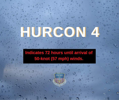
Hurlburt Field AFB in Fort Walton Beach has upped its readiness level.

Image
pictures of link
3 likes   

User avatar
cycloneye
Admin
Admin
Posts: 145327
Age: 68
Joined: Thu Oct 10, 2002 10:54 am
Location: San Juan, Puerto Rico

Re: ATL: NINE - Potential Tropical Cyclone - Discussion

#611 Postby cycloneye » Mon Sep 23, 2024 8:56 pm

Blown Away wrote:Honestly, if the NHC thinks PTC9 will be this MH event in 4 days, regardless of the lack of a clear LLC now, they gotta pull the trigger. Most of the population has no idea what a PTC means…


Waiting for the overnight recon?
1 likes   
Visit the Caribbean-Central America Weather Thread where you can find at first post web cams,radars
and observations from Caribbean basin members Click Here

User avatar
ROCK
Category 5
Category 5
Posts: 9484
Age: 54
Joined: Tue Aug 17, 2004 7:30 am
Location: Kemah, Texas

Re: ATL: NINE - Potential Tropical Cyclone - Discussion

#612 Postby ROCK » Mon Sep 23, 2024 8:59 pm

Blown Away wrote:Honestly, if the NHC thinks PTC9 will be this MH event in 4 days, regardless of the lack of a clear LLC now, they gotta pull the trigger. Most of the population has no idea what a PTC means…


:uarrow:
exactly!!
0 likes   

User avatar
MGC
S2K Supporter
S2K Supporter
Posts: 5899
Joined: Sun Mar 23, 2003 9:05 pm
Location: Pass Christian MS, or what is left.

Re: ATL: NINE - Potential Tropical Cyclone - Discussion

#613 Postby MGC » Mon Sep 23, 2024 8:59 pm

It is becoming apparent that the MCL is where the surface circulation will likely relocate to, currently due south of Grand Cayman. Deep convection has persisted there for over 6 hours and there looks to be increasing vorticity. Lets see what the upcoming recon finds before everyone starts to panic......MGC
2 likes   

Stormlover70
Tropical Storm
Tropical Storm
Posts: 175
Age: 55
Joined: Fri Jun 21, 2024 5:31 am
Location: New port richey

Re: ATL: NINE - Potential Tropical Cyclone - Discussion

#614 Postby Stormlover70 » Mon Sep 23, 2024 9:01 pm

cycloneye wrote:
Blown Away wrote:Honestly, if the NHC thinks PTC9 will be this MH event in 4 days, regardless of the lack of a clear LLC now, they gotta pull the trigger. Most of the population has no idea what a PTC means…


Waiting for the overnight recon?
what time Luis?
0 likes   

3090
Category 2
Category 2
Posts: 549
Age: 65
Joined: Fri Aug 19, 2011 4:01 pm

Re: ATL: NINE - Potential Tropical Cyclone - Discussion

#615 Postby 3090 » Mon Sep 23, 2024 9:02 pm

18Z EURO forecast - weaker at landfall. Good news. Woukd be wonderful if that trend continues.
1 likes   

Stormlover70
Tropical Storm
Tropical Storm
Posts: 175
Age: 55
Joined: Fri Jun 21, 2024 5:31 am
Location: New port richey

Re: ATL: NINE - Potential Tropical Cyclone - Discussion

#616 Postby Stormlover70 » Mon Sep 23, 2024 9:02 pm

MGC wrote:It is becoming apparent that the MCL is where the surface circulation will likely relocate to, currently due south of Grand Cayman. Deep convection has persisted there for over 6 hours and there looks to be increasing vorticity. Lets see what the upcoming recon finds before everyone starts to panic......MGC
that would not be good for west coast
0 likes   

caneman
Category 5
Category 5
Posts: 1447
Joined: Fri Sep 05, 2014 5:44 am
Location: Clearwater Beach, Fl

Re: ATL: NINE - Potential Tropical Cyclone - Discussion

#617 Postby caneman » Mon Sep 23, 2024 9:03 pm

Looks to be ramping now!!
0 likes   

User avatar
cycloneye
Admin
Admin
Posts: 145327
Age: 68
Joined: Thu Oct 10, 2002 10:54 am
Location: San Juan, Puerto Rico

Re: ATL: NINE - Potential Tropical Cyclone - Discussion

#618 Postby cycloneye » Mon Sep 23, 2024 9:05 pm

Stormlover70 wrote:
cycloneye wrote:
Blown Away wrote:Honestly, if the NHC thinks PTC9 will be this MH event in 4 days, regardless of the lack of a clear LLC now, they gotta pull the trigger. Most of the population has no idea what a PTC means…


Waiting for the overnight recon?
what time Luis?


Plane departs at 10:30 PM and will make first pass before the 2 AM intermidiate advisory.
1 likes   
Visit the Caribbean-Central America Weather Thread where you can find at first post web cams,radars
and observations from Caribbean basin members Click Here

User avatar
Blown Away
S2K Supporter
S2K Supporter
Posts: 10146
Joined: Wed May 26, 2004 6:17 am

Re: ATL: NINE - Potential Tropical Cyclone - Discussion

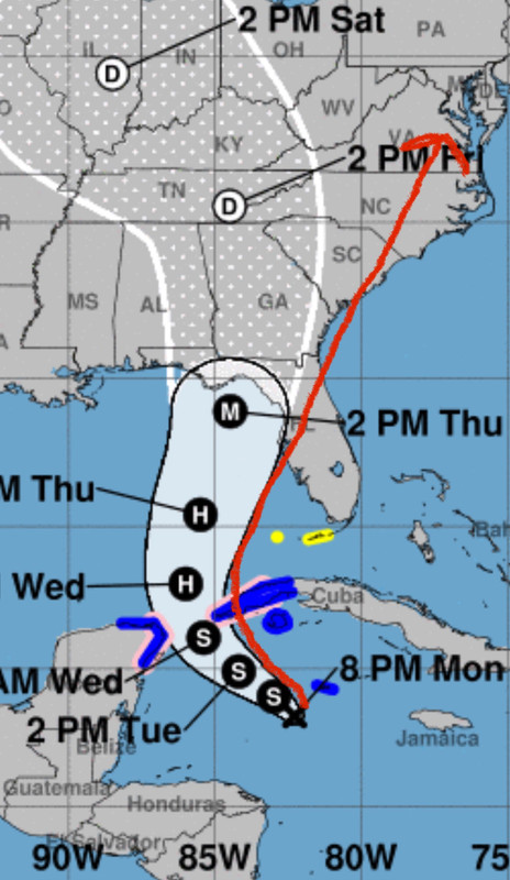
#619 Postby Blown Away » Mon Sep 23, 2024 9:08 pm

Image

My thoughts on how this plays out… JMHO
3 likes   
Hurricane Eye Experience: David 79, Irene 99, Frances 04, Jeanne 04, Wilma 05... EYE COMING MY WAY IN 2024…
Hurricane Brush Experience: Andrew 92, Erin 95, Floyd 99, Matthew 16, Irma 17, Ian 22, Nicole 22…

tolakram
Admin
Admin
Posts: 20009
Age: 62
Joined: Sun Aug 27, 2006 8:23 pm
Location: Florence, KY (name is Mark)

Re: ATL: NINE - Potential Tropical Cyclone - Discussion

#620 Postby tolakram » Mon Sep 23, 2024 9:08 pm

I'm trying to show day vs now as it appears towers are starting to fire around the LLC.
Image
7 likes   
M a r k
- - - - -
Join us in chat: Storm2K Chatroom Invite. Android and IOS apps also available.

The posts in this forum are NOT official forecasts and should not be used as such. Posts are NOT endorsed by any professional institution or STORM2K.org. For official information and forecasts, please refer to NHC and NWS products.


Return to “2024”

Who is online

Users browsing this forum: No registered users and 3 guests