I think, as John moves inland and weakens, the outflow should break down and the shear should decrease as a result.
Now, can the LLC (with the -80C hot tops) and MLC consolidate? I'm thinking this has tropical storm-force winds, but agreed with holding as a PTC for now.
ATL: HELENE - Post-Tropical - Discussion
Moderator: S2k Moderators
Re: ATL: NINE - Potential Tropical Cyclone - Discussion
ROCK wrote:3090 wrote:ROCK wrote:Plane takes off in a hour EC time. Then a upper air sampling mission afterwards. JMO, by the way it looks now, they should find Helene in a few hours. Blasting right by TD status. It is not wasting any time.
I doubt it. ULL is still ripping. Still going to be some time. Let the ULL do its thing as long as possible. But hearing this sentiment for the past 24 hours sooner or later it will happen. Probably some time tomorrow.
I will take that bet...
So what do I win?
1 likes
Re: ATL: NINE - Potential Tropical Cyclone - Discussion
Poonwalker wrote:3090 wrote:ConvergenceZone wrote:
I thought the same initially, but apparently the 18z models were ran with an incorrect center location in error, which is why they were all showing much weaker. Someone just bought that to my attention. So I guess throw those runs. If true that means they should all be bumped up and stronger next run.
Not sure center location as it is now relates to incorrect forecast intensity at landfall. Not certain though.
It certainly would affect the intensity. It would allow a more vertically stacked system spend time over the carribean. Essentially launching a more organized and likely hurricane into the gulf waters.
But will cross more land (Cuba) instead of shooting the YC. Probably a wash at the end of it all.
1 likes
-
StPeteMike

- Category 2

- Posts: 657
- Joined: Thu Jun 07, 2018 11:26 pm
Re: ATL: NINE - Potential Tropical Cyclone - Discussion
NHC has been so conservative recently. Just look at John over in the EPAC. I am kind of shocked to not see an upgrade, I have seen multiple TD look way worse than PTC9.
3 likes
The above post is not official and should not be used as such. It is the opinion of the poster and may or may not be backed by sound meteorological data. It is not endorsed by any professional institution or storm2k.org. For official information, please refer to the NHC and NWS products.
-
Poonwalker
- Category 1

- Posts: 270
- Joined: Tue Sep 20, 2022 11:12 am
Re: ATL: NINE - Potential Tropical Cyclone - Discussion
3090 wrote:Poonwalker wrote:3090 wrote:Not sure center location as it is now relates to incorrect forecast intensity at landfall. Not certain though.
It certainly would affect the intensity. It would allow a more vertically stacked system spend time over the carribean. Essentially launching a more organized and likely hurricane into the gulf waters.
But will cross more land (Cuba) instead of shooting the YC. Probably a wash at the end of it all.
If it goes over Cuba it will hit Florida earlier. That would certainly be a wash in intensity but not cost damage unfortunately.
0 likes
Re: ATL: NINE - Potential Tropical Cyclone - Discussion
Not shocked at all at NHC, it's prudent just to wait for recon on this, the system isn't too hot on radar, and the track forecast is held steady. I don't think they even think about changing much until this system gets a recon vortex message, It's going to be another 24 hours before anything really gets going based on the models.
2 likes
-
tolakram
- Admin

- Posts: 20186
- Age: 62
- Joined: Sun Aug 27, 2006 8:23 pm
- Location: Florence, KY (name is Mark)
Re: ATL: NINE - Potential Tropical Cyclone - Discussion
And with the PTC designation they have issued all the products, watches, and warnings needed. Naming it is academic at this point.
10 likes
M a r k
- - - - -
Join us in chat: Storm2K Chatroom Invite. Android and IOS apps also available.
The posts in this forum are NOT official forecasts and should not be used as such. Posts are NOT endorsed by any professional institution or STORM2K.org. For official information and forecasts, please refer to NHC and NWS products.
-
ConvergenceZone
.gif)
- Category 5

- Posts: 5241
- Joined: Fri Jul 29, 2005 1:40 am
- Location: Northern California
Re: ATL: NINE - Potential Tropical Cyclone - Discussion
3090 wrote:Poonwalker wrote:3090 wrote:Not sure center location as it is now relates to incorrect forecast intensity at landfall. Not certain though.
It certainly would affect the intensity. It would allow a more vertically stacked system spend time over the carribean. Essentially launching a more organized and likely hurricane into the gulf waters.
But will cross more land (Cuba) instead of shooting the YC. Probably a wash at the end of it all.
Regardless the center location does often effect models runs and intensity forecasts. I've seen it happen many times in the past . Also, there have been storms that have went from TS to Major in 24 hours Even if the forecasted strength doesn't change, remember that models aren't great when it comes to forecasting strength. We've seen it most recently with Francine when they almost all showed weakening at landfall and it never happened. So don't read much into what the models are showing in regards to strength, they make lovely liars sometimes.
1 likes
-
CrazyC83
- Professional-Met

- Posts: 34316
- Joined: Tue Mar 07, 2006 11:57 pm
- Location: Deep South, for the first time!
Re: ATL: NINE - Potential Tropical Cyclone - Discussion
ConvergenceZone wrote:3090 wrote:Poonwalker wrote:
It certainly would affect the intensity. It would allow a more vertically stacked system spend time over the carribean. Essentially launching a more organized and likely hurricane into the gulf waters.
But will cross more land (Cuba) instead of shooting the YC. Probably a wash at the end of it all.
Regardless the center location does often effect models runs and intensity forecasts. I've seen it happen many times in the past . Also, there have been storms that have went from TS to Major in 24 hours Even if the forecasted strength doesn't change, remember that models aren't great when it comes to forecasting strength. We've seen it most recently with Francine when they almost all showed weakening at landfall and it never happened. So don't read much into what the models are showing in regards to strength, they make lovely liars sometimes.
Ida crossed Cuba and it didn't stop it from becoming a strong cat 4...
3 likes

Re: ATL: NINE - Potential Tropical Cyclone - Discussion
StPeteMike wrote:NHC has been so conservative recently. Just look at John over in the EPAC. I am kind of shocked to not see an upgrade, I have seen multiple TD look way worse than PTC9.
It’s so odd that they didn’t take the TS-force winds from recon into account.
Although to be fair in regards to John, I don’t think many or any models predicted its Otis-lite RI phase.
3 likes
Irene '11 Sandy '12 Hermine '16 5/15/2018 Derecho Fay '20 Isaias '20 Elsa '21 Henri '21 Ida '21
I am only a meteorology enthusiast who knows a decent amount about tropical cyclones. Look to the professional mets, the NHC, or your local weather office for the best information.
I am only a meteorology enthusiast who knows a decent amount about tropical cyclones. Look to the professional mets, the NHC, or your local weather office for the best information.

Re: ATL: NINE - Potential Tropical Cyclone - Discussion
My boy Reed overselling stuff on YouTube with “Live Update on Cat 3+ Hurricane Helene heading to Florida.”
No offense because I love Reed and watch him all the time. And maybe it’s just a sign of the times where everything has to be extreme for click bait. But come on man. This is PTC9.
No offense because I love Reed and watch him all the time. And maybe it’s just a sign of the times where everything has to be extreme for click bait. But come on man. This is PTC9.
4 likes


Re: ATL: NINE - Potential Tropical Cyclone - Discussion
CrazyC83 wrote:ConvergenceZone wrote:3090 wrote:But will cross more land (Cuba) instead of shooting the YC. Probably a wash at the end of it all.
Regardless the center location does often effect models runs and intensity forecasts. I've seen it happen many times in the past . Also, there have been storms that have went from TS to Major in 24 hours Even if the forecasted strength doesn't change, remember that models aren't great when it comes to forecasting strength. We've seen it most recently with Francine when they almost all showed weakening at landfall and it never happened. So don't read much into what the models are showing in regards to strength, they make lovely liars sometimes.
Ida crossed Cuba and it didn't stop it from becoming a strong cat 4...
Correct the Western tip of Cuba is flat and won't normally impede strength.
0 likes

Re: ATL: NINE - Potential Tropical Cyclone - Discussion
Interesting how NHC made no mention of the weaker 18z model cycle. Perhaps they're also in agreement that the 18z runs were erroneous.
Also, not often do they add a fourth paragraph, much less explicitly saying something like this:
An upper-level low over the northeastern Yucatan Peninsula has been
imparting some southwesterly vertical wind shear over the
disturbance. This has probably caused a temporary disruption in
development. Dynamical guidance shows this low weakening with time,
resulting in a reduction of shear in an environment that is
otherwise very conducive for intensification. The system is
projected to move over waters of very high ocean heat content,
which should lead to considerable strengthening during the forecast
period. The official intensity forecast is similar to the previous
one and lies between the statistical-dynamical model guidance and
the purely dynamical model predictions. It should be noted that
the 72-hour forecast allows for a little weakening after moving
inland, so the cyclone is still expected to be at major hurricane
strength at landfall.
Also, not often do they add a fourth paragraph, much less explicitly saying something like this:
It should also be noted that the cyclone is expected to grow in
size while it traverses the Gulf. Thus, the storm surge, wind, and
rainfall impacts will extend well away from the center, particularly
to the east of the system. In addition, the fast forward speed
while it crosses the coast will likely result in farther inland
penetration of strong winds over parts of the southeastern United
States after landfall.
3 likes
TC naming lists: retirements and intensity
Most aggressive Advisory #1's in North Atlantic (cr. kevin for starting the list)
Most aggressive Advisory #1's in North Atlantic (cr. kevin for starting the list)
-
Nederlander
- S2K Supporter

- Posts: 1259
- Joined: Sat Jul 19, 2008 4:28 pm
- Location: Conroe, TX
Re: ATL: NINE - Potential Tropical Cyclone - Discussion
ConvergenceZone wrote:3090 wrote:18Z EURO forecast - weaker at landfall. Good news. Woukd be wonderful if that trend continues.
I thought the same initially, but apparently the 18z models were ran with an incorrect center location in error, which is why they were all showing much weaker. Someone just bought that to my attention. So I guess throw those runs out. If true that means they should all be bumped up and all showing stronger next run.
Don’t trust the Euro for intensity
0 likes

Re: ATL: NINE - Potential Tropical Cyclone - Discussion
The weak LLC discussed here on radar appears to have been elongated as inflow is surging into the new area of convection. Given how massive the pressure field is right now, a relocation wouldn't be very hard to pull off. Convection just needs to stick here.
2 likes
Kendall -> SLO -> PBC
Memorable Storms: Katrina (for its Florida landfall...) Wilma Matthew Irma
Memorable Storms: Katrina (for its Florida landfall...) Wilma Matthew Irma
-
Nederlander
- S2K Supporter
- Posts: 1259
- Joined: Sat Jul 19, 2008 4:28 pm
- Location: Conroe, TX
Re: ATL: NINE - Potential Tropical Cyclone - Discussion
FLpanhandle91 wrote:Boom. -80 right over the supposed LLC.
Yep, it’s definitely winning out right now
0 likes
-
Typhoon Hunter
- WesternPacificWeather.com

- Posts: 1222
- Joined: Wed Oct 11, 2006 11:37 am
- Location: Tokyo
- Contact:
Re: ATL: NINE - Potential Tropical Cyclone - Discussion
Teban54 wrote:Interesting how NHC made no mention of the weaker 18z model cycle. Perhaps they're also in agreement that the 18z runs were erroneous.
Maybe just waiting a few cycles before seeing if it's a trend. Should be noted the 00z cycle appears weaker than the 18z per Tropical Tidbits
2 likes
-
Nederlander
- S2K Supporter
- Posts: 1259
- Joined: Sat Jul 19, 2008 4:28 pm
- Location: Conroe, TX
Re: ATL: NINE - Potential Tropical Cyclone - Discussion
Would not be surprised if Cancun got a direct hit by a hurricane. It still has about 36 hours before it gets to the channel.
0 likes
Re: ATL: NINE - Potential Tropical Cyclone - Discussion
redingtonbeach wrote:I’ve been calling for a Crystal River landfall ever since the HMON model swung far east, the first one to do so while the others were saying New Orleans or so. Just a gut feeling as I’m no MET but the 200mb and 500mb winds that day, coupled with the progression of other CONUS depictions, made sense at the time. I did not notice the stacking issue in the model, however. It just seemed to be right loaded as it entered the GOM.
No models were saying New Orleans when the HMON first ran yesterday…
0 likes
-
Blown Away

- S2K Supporter
- Posts: 10253
- Joined: Wed May 26, 2004 6:17 am
Re: ATL: NINE - Potential Tropical Cyclone - Discussion
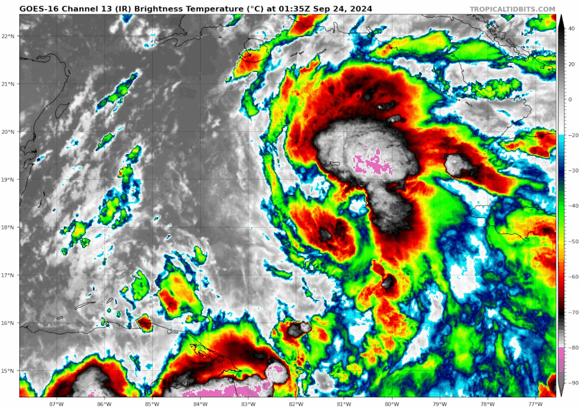
Nice little pulse of deep convection just E of the 11pm position of 18.4N/82.4W… PTC9 Been hanging around this position most of the day…
Last edited by Blown Away on Mon Sep 23, 2024 11:13 pm, edited 1 time in total.
3 likes
Hurricane Eye Experience: David 79, Irene 99, Frances 04, Jeanne 04, Wilma 05… Hurricane Brush Experience: Andrew 92, Erin 95, Floyd 99, Matthew 16, Irma 17, Ian 22, Nicole 22…
Who is online
Users browsing this forum: No registered users and 46 guests