ATL: HELENE - Post-Tropical - Discussion
Moderator: S2k Moderators
-
redingtonbeach
- Tropical Depression

- Posts: 65
- Joined: Mon Sep 04, 2017 12:05 am
Re: ATL: NINE - Potential Tropical Cyclone - Discussion
5:00 AM official NHC update = nearly identical landfall location, a tick earlier CAT 3 intensity, but the approaching track in the GOM has shifted noticeably more east.
2 likes
-
eastcoastFL

- Category 5

- Posts: 3996
- Age: 44
- Joined: Thu Apr 12, 2007 12:29 pm
- Location: Palm City, FL
Re: ATL: NINE - Potential Tropical Cyclone - Discussion
Nederlander wrote:eastcoastFL wrote:TomballEd wrote:Over the on the models thread- after a muted 18Z following a nuclear 12Z series of runs, the high res hurricane models are swinging back to significant hurricane mode.
Upper low near the Yucatan that has been shearing PTC9 is backing W, shear should be dropping as modeled.
https://i.giphy.com/media/v1.Y2lkPTc5MGI3NjExNGM1MnVwcXYzMG9zeDF5c2NiZ3ZseHNxZWozY2RiazNoZHhzN2thNCZlcD12MV9pbnRlcm5hbF9naWZfYnlfaWQmY3Q9Zw/UPNCSoz2xGkhDaLBmv/giphy.gif
It looks like it's going to be tough for the system to split the channel. It might clip the western edge of Cuba.
It’s more likely to hit Cancun or split the channel than Cuba imo
It’s surely possible, the NHC cone covers the entire channel. I just personally think it’s going to be on the eastern edge of the cone at that point. This is my amateur guess.
0 likes
Personal Forecast Disclaimer:
The posts in this forum are NOT official forecast and should not be used as such. They are just the opinion of the poster and may or may not be backed by sound meteorological data. They are NOT endorsed by any professional institution or storm2k.org. For official information, please refer to the NHC and NWS products.
The posts in this forum are NOT official forecast and should not be used as such. They are just the opinion of the poster and may or may not be backed by sound meteorological data. They are NOT endorsed by any professional institution or storm2k.org. For official information, please refer to the NHC and NWS products.

Re: ATL: NINE - Potential Tropical Cyclone - Discussion
redingtonbeach wrote:5:00 AM official NHC update = nearly identical landfall location, a tick earlier CAT 3 intensity, but the approaching track in the GOM has shifted noticeably more east.
Longitude 82.4 is about where Idalia passed last year and you remember the roads that were closed with her.
Just a few inches difference in flood height due to an earlier RI makes the difference between carpet and drywall replacement. I doubt you will need to hunker down in the attic with an axe though.
Last edited by Nimbus on Tue Sep 24, 2024 5:16 am, edited 1 time in total.
1 likes
-
eastcoastFL
- Category 5
- Posts: 3996
- Age: 44
- Joined: Thu Apr 12, 2007 12:29 pm
- Location: Palm City, FL
Re: ATL: NINE - Potential Tropical Cyclone - Discussion
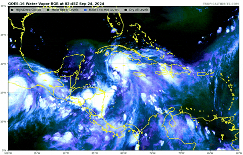
aspen wrote:If I’m looking at and interpreting the WV loop correctly, the source of the shear is an ULL over the Yucatan backing off towards the west, not the outflow from John. Someone correct me if I’m wrong.
You’re correct.
2 likes
Personal Forecast Disclaimer:
The posts in this forum are NOT official forecast and should not be used as such. They are just the opinion of the poster and may or may not be backed by sound meteorological data. They are NOT endorsed by any professional institution or storm2k.org. For official information, please refer to the NHC and NWS products.
The posts in this forum are NOT official forecast and should not be used as such. They are just the opinion of the poster and may or may not be backed by sound meteorological data. They are NOT endorsed by any professional institution or storm2k.org. For official information, please refer to the NHC and NWS products.
Re: ATL: NINE - Potential Tropical Cyclone - Discussion
eastcoastFL wrote:aspen wrote:If I’m looking at and interpreting the WV loop correctly, the source of the shear is an ULL over the Yucatan backing off towards the west, not the outflow from John. Someone correct me if I’m wrong.
You’re correct.
My understanding is that one it gets North of the ULL it will then help to enhance it.
0 likes
-
Blown Away

- S2K Supporter

- Posts: 10253
- Joined: Wed May 26, 2004 6:17 am
Re: ATL: NINE - Potential Tropical Cyclone - Discussion
Geez only 3-4 days out and the lack of a clearly defined LLC leaves just enough track uncertainty for PTC9 to go anywhere from Naples to Panama City. JMHO
1 likes
Hurricane Eye Experience: David 79, Irene 99, Frances 04, Jeanne 04, Wilma 05… Hurricane Brush Experience: Andrew 92, Erin 95, Floyd 99, Matthew 16, Irma 17, Ian 22, Nicole 22…
-
chris_fit

- Category 5
- Posts: 3261
- Age: 43
- Joined: Wed Sep 10, 2003 11:58 pm
- Location: Tampa Bay Area, FL
Re: ATL: NINE - Potential Tropical Cyclone - Discussion
Recon missing a dataset, but it appears it's north/right of the forecast track in the short term? Blue line is official forecast track.

3 likes
Re: ATL: NINE - Potential Tropical Cyclone - Discussion
Blown Away wrote:Geez only 3-4 days out and the lack of a clearly defined LLC leaves just enough track uncertainty for PTC9 to go anywhere from Naples to Panama City. JMHO
The first plane through was not doing a classic survey, once they get a NE to SW run they can nail down the center. But from NOAA mission 4 you can easily see where it is.

1 likes

Re: ATL: NINE - Potential Tropical Cyclone - Discussion
chris_fit wrote:Recon missing a dataset, but it appears it's north/right of the forecast track in the short term? Blue line is official forecast track.
https://i.imgur.com/yVyuYXN.png
Of course the one section of data it’s missing is from the exact center lol.
3 likes
Irene '11 Sandy '12 Hermine '16 5/15/2018 Derecho Fay '20 Isaias '20 Elsa '21 Henri '21 Ida '21
I am only a meteorology enthusiast who knows a decent amount about tropical cyclones. Look to the professional mets, the NHC, or your local weather office for the best information.
I am only a meteorology enthusiast who knows a decent amount about tropical cyclones. Look to the professional mets, the NHC, or your local weather office for the best information.
Re: ATL: NINE - Potential Tropical Cyclone - Discussion
xironman wrote:Blown Away wrote:Geez only 3-4 days out and the lack of a clearly defined LLC leaves just enough track uncertainty for PTC9 to go anywhere from Naples to Panama City. JMHO
The first plane through was not doing a classic survey, once they get a NE to SW run they can nail down the center. But from NOAA mission 4 you can easily see where it is.
https://i.imgur.com/a8PKFMl.png
It's nearly a full degree North and slightly east of the 5 am update.
0 likes
Re: ATL: NINE - Potential Tropical Cyclone - Discussion
chris_fit wrote:Recon missing a dataset, but it appears it's north/right of the forecast track in the short term? Blue line is official forecast track.
https://i.imgur.com/yVyuYXN.png
The retreating upper level low will tend to tug it west a little later in the forecast when its a deeper system but the NNW initial motion does appear to have continued a few hours longer than initially thought(or bothered to be concerned with for Cuba).
1 likes
Re: ATL: NINE - Potential Tropical Cyclone - Discussion
caneman wrote:xironman wrote:Blown Away wrote:Geez only 3-4 days out and the lack of a clearly defined LLC leaves just enough track uncertainty for PTC9 to go anywhere from Naples to Panama City. JMHO
The first plane through was not doing a classic survey, once they get a NE to SW run they can nail down the center. But from NOAA mission 4 you can easily see where it is.
https://i.imgur.com/a8PKFMl.png
It's nearly a full degree North and slightly east of the 5 am update.
It looked like there was a center reformation or it got pulled north by the MLC going on a few hours ago using SWIR
1 likes

Re: ATL: NINE - Potential Tropical Cyclone - Discussion
Note that most models nearly bring NINE to Yucatan. So even if NINE is more east/north than forecast I don't think it's that much at risk of hitting Cuba. If anything, it'll allow for an even clearer run through the channel between Yucatan and Cuba.
1 likes
Re: ATL: NINE - Potential Tropical Cyclone - Discussion
kevin wrote:Note that most models nearly bring NINE to Yucatan. So even if NINE is more east/north than forecast I don't think it's that much at risk of hitting Cuba. If anything, it'll allow for an even clearer run through the channel between Yucatan and Cuba.
Possibly leaning more towards the right side of forecast cone towards landfall putting Cedar Key and possibly down to Cutrus county more at risk and Tampa Bay for even more effects. But these movements can also tend to smooth out over time unless of course this is a true center relocation. It may also mean we now have a fully stacked system.
0 likes
-
eastcoastFL
- Category 5
- Posts: 3996
- Age: 44
- Joined: Thu Apr 12, 2007 12:29 pm
- Location: Palm City, FL
Re: ATL: NINE - Potential Tropical Cyclone - Discussion
PTC9 doesn't yet look structurally impressive but it sure is growing in overall size with quite a bit of deep convection and cold cloud tops to the east of center. I can imagine it will be significantly larger once shear abates, it gets stacked and it fills into the west.
It might not look like much this morning but that can change rapidly in this environment.
It might not look like much this morning but that can change rapidly in this environment.
2 likes
Personal Forecast Disclaimer:
The posts in this forum are NOT official forecast and should not be used as such. They are just the opinion of the poster and may or may not be backed by sound meteorological data. They are NOT endorsed by any professional institution or storm2k.org. For official information, please refer to the NHC and NWS products.
The posts in this forum are NOT official forecast and should not be used as such. They are just the opinion of the poster and may or may not be backed by sound meteorological data. They are NOT endorsed by any professional institution or storm2k.org. For official information, please refer to the NHC and NWS products.
-
Keldeo1997
- Category 2

- Posts: 688
- Joined: Fri Oct 11, 2019 11:35 pm

-
cycloneye

- Admin

- Posts: 149721
- Age: 69
- Joined: Thu Oct 10, 2002 10:54 am
- Location: San Juan, Puerto Rico
Re: ATL: NINE - Potential Tropical Cyclone - Discussion
There is the center at AF pass.

3 likes
Visit the Caribbean-Central America Weather Thread where you can find at first post web cams,radars
and observations from Caribbean basin members Click Here
and observations from Caribbean basin members Click Here
-
Hypercane_Kyle

- Category 5
- Posts: 3465
- Joined: Sat Mar 07, 2015 7:58 pm
- Location: Cape Canaveral, FL
Re: ATL: NINE - Potential Tropical Cyclone - Discussion
09L is looking better organization this morning. Definitely getting some shear still from the ULL, likely as a result of John. Now that John is weakening and will quickly be out of the picture, I anticipate gradual organization today followed by rapid intensification once it passes Cuba.

1 likes
My posts are my own personal opinion, defer to the National Hurricane Center (NHC) and other NOAA products for decision making during hurricane season.
-
eastcoastFL
- Category 5
- Posts: 3996
- Age: 44
- Joined: Thu Apr 12, 2007 12:29 pm
- Location: Palm City, FL
Re: ATL: NINE - Potential Tropical Cyclone - Discussion
aspen wrote:chris_fit wrote:Recon missing a dataset, but it appears it's north/right of the forecast track in the short term? Blue line is official forecast track.
https://i.imgur.com/yVyuYXN.png
Of course the one section of data it’s missing is from the exact center lol.
Do you know if the last ASCAT caught PTC9?
1 likes
Personal Forecast Disclaimer:
The posts in this forum are NOT official forecast and should not be used as such. They are just the opinion of the poster and may or may not be backed by sound meteorological data. They are NOT endorsed by any professional institution or storm2k.org. For official information, please refer to the NHC and NWS products.
The posts in this forum are NOT official forecast and should not be used as such. They are just the opinion of the poster and may or may not be backed by sound meteorological data. They are NOT endorsed by any professional institution or storm2k.org. For official information, please refer to the NHC and NWS products.
-
eastcoastFL
- Category 5
- Posts: 3996
- Age: 44
- Joined: Thu Apr 12, 2007 12:29 pm
- Location: Palm City, FL
Re: ATL: NINE - Potential Tropical Cyclone - Discussion
kevin wrote:Note that most models nearly bring NINE to Yucatan. So even if NINE is more east/north than forecast I don't think it's that much at risk of hitting Cuba. If anything, it'll allow for an even clearer run through the channel between Yucatan and Cuba.
It's hard to tell but it appears that it's been east of the track so far. That's why my guess is that it will hug the eastern side of the cone and brush western Cuba. The models will have a better idea once they ingest the data from this mornings flights.
0 likes
Personal Forecast Disclaimer:
The posts in this forum are NOT official forecast and should not be used as such. They are just the opinion of the poster and may or may not be backed by sound meteorological data. They are NOT endorsed by any professional institution or storm2k.org. For official information, please refer to the NHC and NWS products.
The posts in this forum are NOT official forecast and should not be used as such. They are just the opinion of the poster and may or may not be backed by sound meteorological data. They are NOT endorsed by any professional institution or storm2k.org. For official information, please refer to the NHC and NWS products.
Who is online
Users browsing this forum: No registered users and 68 guests