ATL: HELENE - Post-Tropical - Discussion
Moderator: S2k Moderators
-
Pipelines182
- Tropical Storm

- Posts: 159
- Joined: Tue Jul 02, 2024 8:46 am
Re: ATL: HELENE - Tropical Storm - Discussion
What's the implications of a delayed landfall, further east or west?
0 likes
-
ScottNAtlanta

- Category 5

- Posts: 2535
- Joined: Sat May 25, 2013 3:11 pm
- Location: Atlanta, GA
Re: ATL: HELENE - Tropical Storm - Discussion
wxman57 wrote:Stormlover70 wrote:for now it is good news for us at leastMetroMike wrote:
You can't say its good news at this time. The NHC says future track adjustments may be made in later cycles.
The cone is completely irrelevant as far as potential impacts. The cone is the same for every storm, every advisory, no matter the confidence level or the storm size. In this case strong TS and even hurricane wind will extend outside that cone. Some good news for the western FL Peninsula is that the new ICON run is a bit farther west of Tampa. That would keep Tampa out of sustained hurricane force wind, but he area may still see wind gusts 70-85 mph.
The local met discussion indicates they will be issuing a Tropical Storm Watch for the Atlanta Metro when we get within the timing for it
0 likes
The posts in this forum are NOT official forecast and should not be used as such. They are just the opinion of the poster and may or may not be backed by sound meteorological data. They are NOT endorsed by any professional institution or storm2k.org. For official information, please refer to the NHC and NWS products.
-
TomballEd
- Category 5
- Posts: 1322
- Age: 62
- Joined: Wed Aug 16, 2023 4:52 pm
- Location: Spring/Klein area, not Tomball
Re: ATL: HELENE - Tropical Storm - Discussion
Re: Max surge into the Florida Big Bend and Tampa Bay. I see 5 feet possible in Tampa Bay. Dr. Tang is at U-Albany, which seems to produce more than its share of good mets.
https://x.com/btangyWx/status/1838615817044308325
https://x.com/btangyWx/status/1838615817044308325
0 likes
-
Frank P
- S2K Supporter

- Posts: 2779
- Joined: Fri Aug 29, 2003 10:52 am
- Location: Biloxi Beach, Ms
- Contact:
Re: ATL: HELENE - Tropical Storm - Discussion
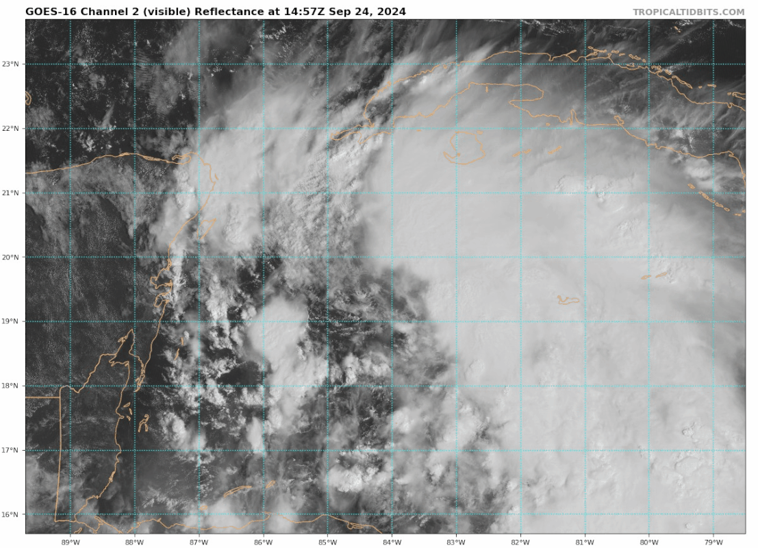
There is the little HT firing on the NE, center at 19.3n and 84.5w

Last edited by Frank P on Tue Sep 24, 2024 11:32 am, edited 1 time in total.
0 likes
-
cycloneye

- Admin

- Posts: 149746
- Age: 69
- Joined: Thu Oct 10, 2002 10:54 am
- Location: San Juan, Puerto Rico
Re: ATL: HELENE - Tropical Storm - Discussion
A nascent burst.

1 likes
Visit the Caribbean-Central America Weather Thread where you can find at first post web cams,radars
and observations from Caribbean basin members Click Here
and observations from Caribbean basin members Click Here
-
Hypercane_Kyle

- Category 5
- Posts: 3465
- Joined: Sat Mar 07, 2015 7:58 pm
- Location: Cape Canaveral, FL
Re: ATL: HELENE - Tropical Storm - Discussion
Shear is still absolutely ripping over Helene. I don’t think this was well forecast at all by the models. If it can’t establish an inner core and then hits the Yucatán, the bar for intensity will be much lower and more in line with the current NHC forecast.
2 likes
My posts are my own personal opinion, defer to the National Hurricane Center (NHC) and other NOAA products for decision making during hurricane season.

Re: ATL: HELENE - Tropical Storm - Discussion
Hypercane_Kyle wrote:Shear is still absolutely ripping over Helene. I don’t think this was well forecast at all by the models. If it can’t establish an inner core and then hits the Yucatán, the bar for intensity will be much lower and more in line with the current NHC forecast.
The GFS since 18z yesterday has been showing some shear around this period into the Yucatan passage crossing. NHC says shear is starting to let up now, you can see the high clouds are no longer soaring to the northeast on popup convection.
Last edited by Ubuntwo on Tue Sep 24, 2024 11:36 am, edited 1 time in total.
2 likes
Kendall -> SLO -> PBC
Memorable Storms: Katrina (for its Florida landfall...) Wilma Matthew Irma
Memorable Storms: Katrina (for its Florida landfall...) Wilma Matthew Irma
-
ScottNAtlanta
- Category 5
- Posts: 2535
- Joined: Sat May 25, 2013 3:11 pm
- Location: Atlanta, GA
Re: ATL: HELENE - Tropical Storm - Discussion
Hypercane_Kyle wrote:Shear is still absolutely ripping over Helene. I don’t think this was well forecast at all by the models. If it can’t establish an inner core and then hits the Yucatán, the bar for intensity will be much lower and more in line with the current NHC forecast.
I respectfully disagree on that one. There is very little shear over the storm right now. Looking at WV you see no shear currently
6 likes
The posts in this forum are NOT official forecast and should not be used as such. They are just the opinion of the poster and may or may not be backed by sound meteorological data. They are NOT endorsed by any professional institution or storm2k.org. For official information, please refer to the NHC and NWS products.
Re: ATL: HELENE - Tropical Storm - Discussion
Hypercane_Kyle wrote:Shear is still absolutely ripping over Helene. I don’t think this was well forecast at all by the models. If it can’t establish an inner core and then hits the Yucatán, the bar for intensity will be much lower and more in line with the current NHC forecast.
And thus why they are the world’s best at specifically what they are tasked with.
0 likes
Re: ATL: HELENE - Tropical Storm - Discussion
Light shear but ingesting some drier air.ScottNAtlanta wrote:Hypercane_Kyle wrote:Shear is still absolutely ripping over Helene. I don’t think this was well forecast at all by the models. If it can’t establish an inner core and then hits the Yucatán, the bar for intensity will be much lower and more in line with the current NHC forecast.
I respectfully disagree on that one. There is very little shear over the storm right now. Looking at WV you see no shear currently
0 likes
-
emeraldislenc
- Category 2

- Posts: 602
- Joined: Fri Aug 24, 2012 4:49 pm
- Location: Emerald Isle NC
-
ScottNAtlanta
- Category 5
- Posts: 2535
- Joined: Sat May 25, 2013 3:11 pm
- Location: Atlanta, GA
Re: ATL: HELENE - Tropical Storm - Discussion
3090 wrote:Light shear but ingesting some drier air.ScottNAtlanta wrote:Hypercane_Kyle wrote:Shear is still absolutely ripping over Helene. I don’t think this was well forecast at all by the models. If it can’t establish an inner core and then hits the Yucatán, the bar for intensity will be much lower and more in line with the current NHC forecast.
I respectfully disagree on that one. There is very little shear over the storm right now. Looking at WV you see no shear currently
Not really any dry air showing up on WV either. Sometimes it just takes more time for these large systems to pull it all together. It will happen with a little more time. Patience grasshopper, patience.
2 likes
The posts in this forum are NOT official forecast and should not be used as such. They are just the opinion of the poster and may or may not be backed by sound meteorological data. They are NOT endorsed by any professional institution or storm2k.org. For official information, please refer to the NHC and NWS products.
Re: ATL: HELENE - Tropical Storm - Discussion
As others have mentioned a meso starting to circle an nascent eyewall

2 likes
-
Pipelines182
- Tropical Storm
- Posts: 159
- Joined: Tue Jul 02, 2024 8:46 am
Re: ATL: HELENE - Tropical Storm - Discussion
That's the very first convective burst I've seen associated with the LLC, if Helene can keep these coming we may be on to something.
1 likes
Re: ATL: HELENE - Tropical Storm - Discussion
Hypercane_Kyle wrote:Shear is still absolutely ripping over Helene. I don’t think this was well forecast at all by the models. If it can’t establish an inner core and then hits the Yucatán, the bar for intensity will be much lower and more in line with the current NHC forecast.
I really expected a lot more by this point. A naked swirl was not on my bingo card today. The system still looks like complete mess
4 likes
-
Weatherboy1

- Category 5
- Posts: 1190
- Age: 50
- Joined: Mon Jul 05, 2004 1:50 pm
- Location: Jupiter/Sarasota, FL
Re: ATL: HELENE - Tropical Storm - Discussion
I think this erratic short-term movement is actually LIKELY the pre-cursor to the turn. Prior dominant steering force (high N/NE of Florida) giving way to the next dominant steering force (low over AR/SE US), which will take over soon. IF I'm right, we're going to see a turn well before the Yucatan, which could have implications for future landfall point. We'll see.
3 likes
-
Blown Away

- S2K Supporter
- Posts: 10253
- Joined: Wed May 26, 2004 6:17 am
Re: ATL: HELENE - Tropical Storm - Discussion
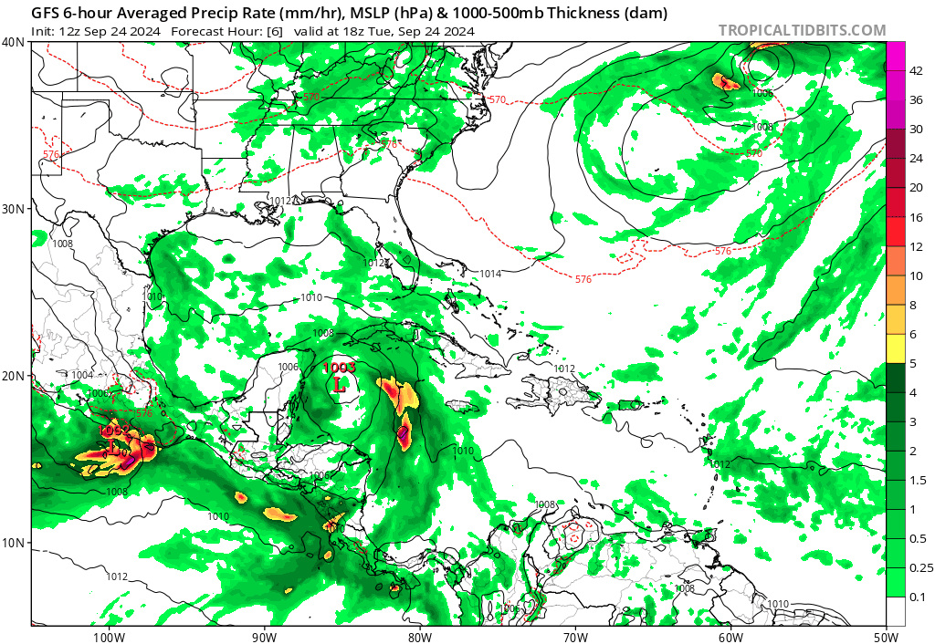
12z GFS tracked that little exposed eddy/LLC and moved it WSW to W for next @18 hrs. The cloud mass continues to move to NW, this has to be the point where a new LLC could reform and change the track models like the GFS have been showing and NHC mentioned as a possibility at 11am.
1 likes
Hurricane Eye Experience: David 79, Irene 99, Frances 04, Jeanne 04, Wilma 05… Hurricane Brush Experience: Andrew 92, Erin 95, Floyd 99, Matthew 16, Irma 17, Ian 22, Nicole 22…
-
ScottNAtlanta
- Category 5
- Posts: 2535
- Joined: Sat May 25, 2013 3:11 pm
- Location: Atlanta, GA
Re: ATL: HELENE - Tropical Storm - Discussion
I still don't think that's the main center. It looks like it is starting to move east indicative of a rotating center
0 likes
The posts in this forum are NOT official forecast and should not be used as such. They are just the opinion of the poster and may or may not be backed by sound meteorological data. They are NOT endorsed by any professional institution or storm2k.org. For official information, please refer to the NHC and NWS products.
-
Frank P
- S2K Supporter
- Posts: 2779
- Joined: Fri Aug 29, 2003 10:52 am
- Location: Biloxi Beach, Ms
- Contact:
Re: ATL: HELENE - Tropical Storm - Discussion
psyclone wrote:Hypercane_Kyle wrote:Shear is still absolutely ripping over Helene. I don’t think this was well forecast at all by the models. If it can’t establish an inner core and then hits the Yucatán, the bar for intensity will be much lower and more in line with the current NHC forecast.
I really expected a lot more by this point. A naked swirl was not on my bingo card today. The system still looks like complete mess
Sure looks to me that it's pulling all that convection from the east and SW towards that center..
1 likes
Re: ATL: HELENE - Tropical Storm - Discussion
Frank P wrote:psyclone wrote:Hypercane_Kyle wrote:Shear is still absolutely ripping over Helene. I don’t think this was well forecast at all by the models. If it can’t establish an inner core and then hits the Yucatán, the bar for intensity will be much lower and more in line with the current NHC forecast.
I really expected a lot more by this point. A naked swirl was not on my bingo card today. The system still looks like complete mess
Sure looks to me that it's pulling all that convection from the east and SW towards that center..
Probably a situation of delayed but not denied
1 likes
Who is online
Users browsing this forum: No registered users and 54 guests