ATL: HELENE - Models
Moderator: S2k Moderators
-
tolakram
- Admin

- Posts: 20186
- Age: 62
- Joined: Sun Aug 27, 2006 8:23 pm
- Location: Florence, KY (name is Mark)
Re: ATL: HELENE - Models
Seeing some of the models scrape the Yuk reminds me of the issue with a single plot hurricane model. Land interaction will tend to screw up the entire run, and if it's wrong then the final intensity will probably be wrong. Is there such a thing as ensembles for the newer HAFs models?
0 likes
M a r k
- - - - -
Join us in chat: Storm2K Chatroom Invite. Android and IOS apps also available.
The posts in this forum are NOT official forecasts and should not be used as such. Posts are NOT endorsed by any professional institution or STORM2K.org. For official information and forecasts, please refer to NHC and NWS products.

Re: ATL: HELENE - Models
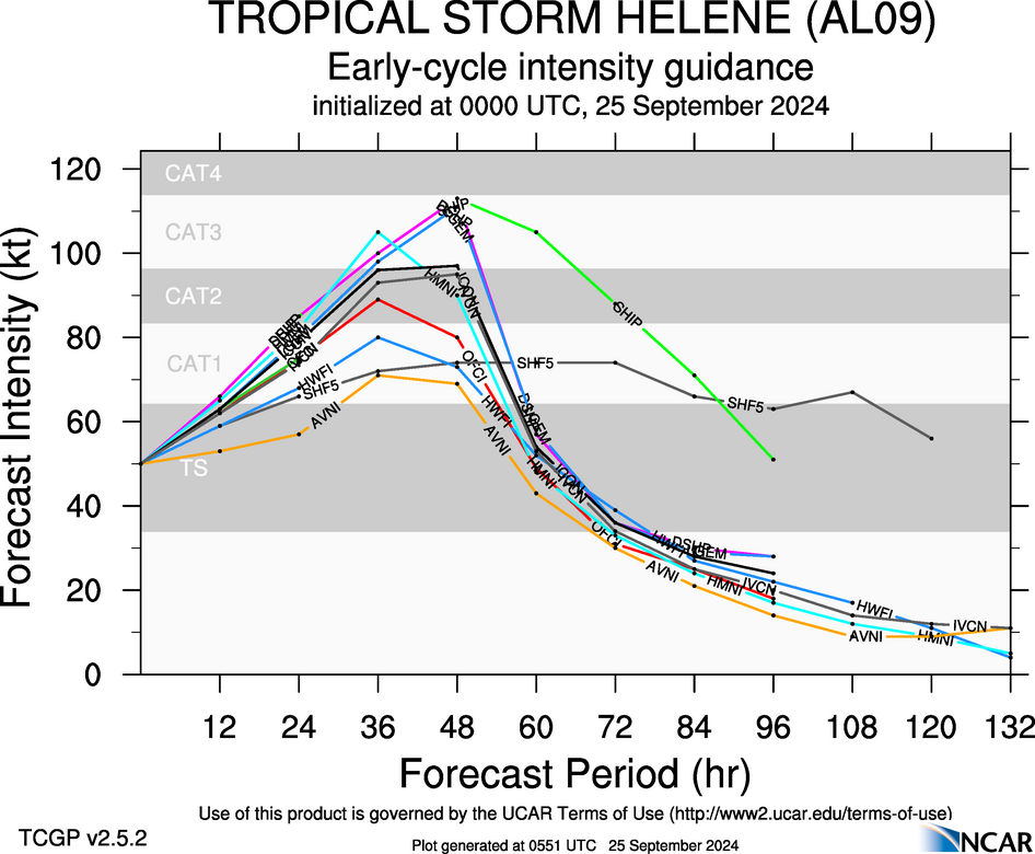
This is the strongest forecast yet by SHIPS, near Cat 4 before landfall with a fairly good chance for RI over the next 48 hrs.


4 likes

Re: ATL: HELENE - Models
NDG wrote:This is the strongest forecast yet by SHIPS, near Cat 4 before landfall with a fairly good chance for RI over the next 48 hrs.
https://i.imgur.com/rTImLkV.gif
https://i.imgur.com/uodsOeI.gif

3 likes

Re: ATL: HELENE - Models
Early cycle still likes Franklin/Wakulla
https://hurricanes.ral.ucar.edu/realtim ... _early.png
Early intensity is strong as well Think we all figured Cat 2 but reasonable shot at a 3 with some of those.
https://hurricanes.ral.ucar.edu/realtim ... _early.png
https://hurricanes.ral.ucar.edu/realtim ... _early.png
Early intensity is strong as well Think we all figured Cat 2 but reasonable shot at a 3 with some of those.
https://hurricanes.ral.ucar.edu/realtim ... _early.png
1 likes

Re: ATL: HELENE - Models
BobHarlem wrote:NDG wrote:This is the strongest forecast yet by SHIPS, near Cat 4 before landfall with a fairly good chance for RI over the next 48 hrs.
https://i.imgur.com/rTImLkV.gif
https://i.imgur.com/uodsOeI.gif
https://i.imgur.com/Zic63nM.png
On one hand there's a significant drop in mid level relative humidity, couple with upper level shear increasing - both right around 48 hr's. On the other hand, the storm may practically be on the doorstep to landfall.
0 likes
Andy D
(For official information, please refer to the NHC and NWS products.)
(For official information, please refer to the NHC and NWS products.)
Re: ATL: HELENE - Models
I just got off the phone with my friends in Crawfordville (Wakulla county). Everything is already closed down already and there is a mandatory evacuation order in place. I've never heard of a mandatory evacuation for a whole county?!
4 likes
Andy D
(For official information, please refer to the NHC and NWS products.)
(For official information, please refer to the NHC and NWS products.)
-
gatorcane

- S2K Supporter

- Posts: 23708
- Age: 48
- Joined: Sun Mar 13, 2005 3:54 pm
- Location: Boca Raton, FL
Re: ATL: HELENE - Models
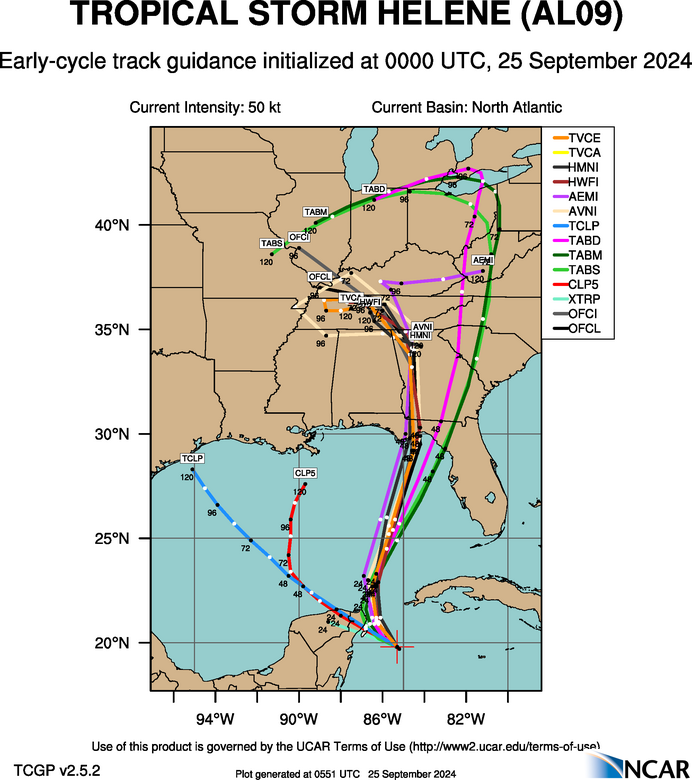
Anybody notice how there is a relatively sizeable difference between the GFS and ECMWF between hours 24 and 42 as far as the track once it makes the turn NE near the Yucatan with the ECMWF more to the east and the GFS more to the west? The models end up converging again around 48 hours but I do wonder if the GFS will shift more to the right during this timeframe or whether ECMWF will shift more to the left. Usually the ECMWF is on the left and the GFS is on the right.
18Z ECMWF track below:
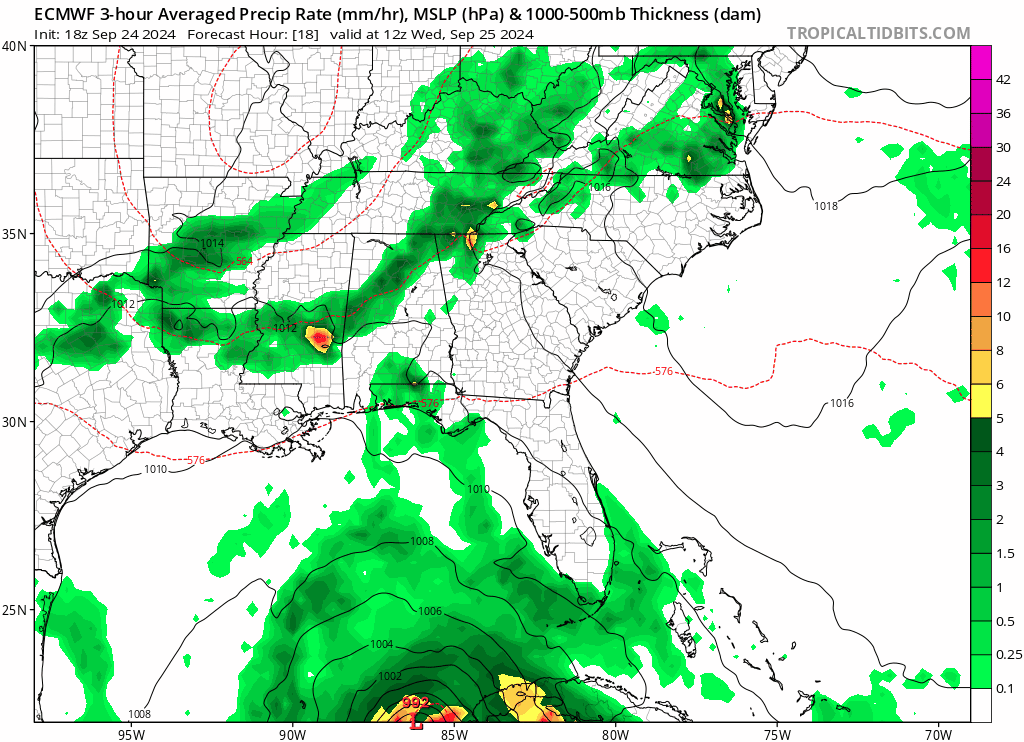
18Z ECMWF track below:
0 likes
-
USTropics
- Professional-Met

- Posts: 2739
- Joined: Sun Aug 12, 2007 3:45 am
- Location: Florida State University
Re: ATL: HELENE - Models
Some of us MET students at FSU (mixture of grads/undergrads) will be posting articles before the event, somewhat during, and (power permitting) afterwards. We'll be doing a mixture of current observations, some informative/teaching posts, and other cool things! If you have any suggestions or topics you want us to cover, just drop a comment or message me.
https://rcedergren8.wixsite.com/northflams/post/forecasting-helene-using-satellite-imagery-1
https://rcedergren8.wixsite.com/northflams/post/forecasting-helene-using-satellite-imagery-1
4 likes

Re: ATL: HELENE - Models
chaser1 wrote:I just got off the phone with my friends in Crawfordville (Wakulla county). Everything is already closed down already and there is a mandatory evacuation order in place. I've never heard of a mandatory evacuation for a whole county?!
Yes this is where i live by the coast, we are leaving in the morning. Most of my neighbors are staying. Crazy
2 likes
Re: ATL: HELENE - Models
chaser1 wrote:BobHarlem wrote:NDG wrote:This is the strongest forecast yet by SHIPS, near Cat 4 before landfall with a fairly good chance for RI over the next 48 hrs.
https://i.imgur.com/rTImLkV.gif
https://i.imgur.com/uodsOeI.gif
https://i.imgur.com/Zic63nM.png
On one hand there's a significant drop in mid level relative humidity, couple with upper level shear increasing - both right around 48 hr's. On the other hand, the storm may practically be on the doorstep to landfall.
17 knots of shear parallel to its track is probably not enough to weaken it before landfall. Francine had 20-30 knots and was still able to intensify into a Cat 2 before landfall.
1 likes

Re: ATL: HELENE - Models
sweetpea wrote:chaser1 wrote:I just got off the phone with my friends in Crawfordville (Wakulla county). Everything is already closed down already and there is a mandatory evacuation order in place. I've never heard of a mandatory evacuation for a whole county?!
Yes this is where i live by the coast, we are leaving in the morning. Most of my neighbors are staying. Crazy
We are in Zone B... I wanted to stay, but the better half convinced me that we should head west and make a mini-vacation of it.
0 likes
Re: ATL: HELENE - Models
0z icon is rolling, coming in a little stronger than 18z so far 959mb at 36 hours, track is about the same out to 36 hours.
0 likes
Re: ATL: HELENE - Models
FV3 out to 60 hours (7am cdt friday) cut off grabs Helene.
https://www.tropicaltidbits.com/analysi ... 2500&fh=60
It’s got rainfall at landfall, across N GA and W NC.
https://www.tropicaltidbits.com/analysi ... 2500&fh=60
https://www.tropicaltidbits.com/analysi ... 2500&fh=60
It’s got rainfall at landfall, across N GA and W NC.
https://www.tropicaltidbits.com/analysi ... 2500&fh=60
0 likes
-
lsuhurricane
- Category 1

- Posts: 270
- Joined: Tue Aug 15, 2017 2:53 pm
Re: ATL: HELENE - Models
0z Icon with a hit near Steinhatchee this time about 10mb lower pressure than 18z on this run.

Last edited by BobHarlem on Tue Sep 24, 2024 9:58 pm, edited 1 time in total.
0 likes
-
TallyTracker
- Category 2

- Posts: 787
- Joined: Thu Oct 11, 2018 2:46 pm
Re: ATL: HELENE - Models
chaser1 wrote:I just got off the phone with my friends in Crawfordville (Wakulla county). Everything is already closed down already and there is a mandatory evacuation order in place. I've never heard of a mandatory evacuation for a whole county?!
Most of the County is forecast to go under water. Surge actually reaches Leon County in the worst storm scenarios (of which Helene is likely the prime example).
https://floridadisaster.maps.arcgis.com/apps/instant/lookup/index.html?appid=aa18a2d8737c4d66bb6434a09e17203a
0 likes
Fran '96, Georges '98, Gordon '00, Gabrielle '01, Charley '04, Frances '04, Jeanne '04, Barry '07, Fay '08, Debby '12, Matthew '16, Emily '17, Irma '17, Michael ‘18, Elsa ‘21, Fred ‘21, Mindy ‘21, Nicole ‘22, Idalia ‘23, Debby ‘24, Helene ‘24
Re: ATL: HELENE - Models
BobHarlem wrote:0z Icon with a hit near Steinhatchee this time about 10mb lower pressure than 18z on this run.
https://i.imgur.com/C5e3tK9.png
That’s a big hit. It’s still east of most models but we’ll see.
0 likes
Re: ATL: HELENE - Models
TallyTracker wrote:chaser1 wrote:I just got off the phone with my friends in Crawfordville (Wakulla county). Everything is already closed down already and there is a mandatory evacuation order in place. I've never heard of a mandatory evacuation for a whole county?!
Most of the County is forecast to go under water. Surge actually reaches Leon County in the worst storm scenarios (of which Helene is likely the prime example).
https://floridadisaster.maps.arcgis.com/apps/instant/lookup/index.html?appid=aa18a2d8737c4d66bb6434a09e17203a
Yeah not liking that, I am in that red area. We leave in the morning, we will see what we come back too. Most of my neighbors are staying.
0 likes

Who is online
Users browsing this forum: No registered users and 73 guests