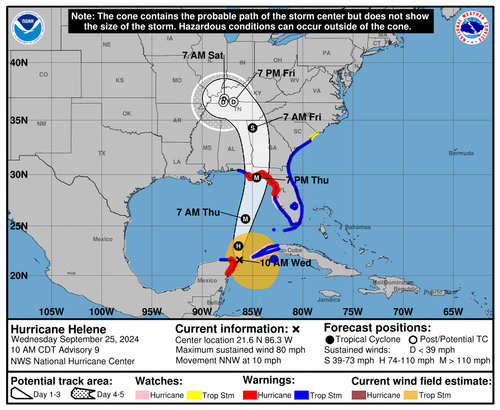
ATL: HELENE - Post-Tropical - Discussion

Moderator: S2k Moderators

Message
Author
User avatar
tronbunny
S2K Supporter
S2K Supporter
Posts: 1558
Joined: Wed Sep 01, 2004 1:18 am
Location: Central FL

Re: ATL: HELENE - Tropical Storm - Discussion

#1601 Postby tronbunny » Wed Sep 25, 2024 10:21 am

CronkPSU wrote:i am lookign at the weather channel's forecast for Tally, and the highest winds forecast are just above 50 mph and just one hour of 65 mph as it passes by...that seems really low for what they are forecasting the storm to be around landfall and how quickly it moves thru Tally after landfall, what am I missing?

Something sounds off about that. the old trees in that city are a hazard unto themselves.
https://www.weather.gov/srh/tropical?office=tae#hti
Last edited by tronbunny on Wed Sep 25, 2024 10:23 am, edited 1 time in total.
2 likes   

jlauderdal
S2K Supporter
S2K Supporter
Posts: 7183
Joined: Wed May 19, 2004 5:46 am
Location: NE Fort Lauderdale
Contact:

Re: ATL: HELENE - Tropical Storm - Discussion

#1602 Postby jlauderdal » Wed Sep 25, 2024 10:21 am

AtlanticWind wrote:Lived in South Florida all my life
We just had a rainband move in from a
Tropical storm that is 500 miles away

Incredible how large Helene is
Getting that band now, 2.5 in/hr. with lighting
3 likes   

Pipelines182
Tropical Storm
Tropical Storm
Posts: 159
Joined: Tue Jul 02, 2024 8:46 am

Re: ATL: HELENE - Tropical Storm - Discussion

#1603 Postby Pipelines182 » Wed Sep 25, 2024 10:22 am

jdjaguar wrote:
Steve wrote:
lovingseason2013 wrote:Has anyone ever heard of Panacea, FL??? I think you just proved the guy's point, that there is no large metropolitan area in the crosshairs. While it will be devasting for a town like Panacea, it is small-scale compared to a Tampa type of event. I hope they fare okay given what is headed their way.


Yes. I've been there. And we have some members here from there. Also Alligator Point is going to get wrecked. Most of the center and eastern part of the bay is state parks and wildlife refuges/estuaries. But there are actually some decent little towns tucked away in what you'd think are nowhere like Shell Point and Live Oak Point. Shell Point has a bunch of homes on canals with boat docks. You'd never even know it was there if you didn't need to know about it. It's getting wrecked too, and I'd be surprised if there was much left if the surge gets as high as it might. It is very sparse beyond that until you get over to Perry and Adams Beach

I get the point though. If somewhere's got to get hit, the least populated portion is best for the common good.


I go there twice a year and stay with friends at their coastal home. I guess it was just the callousness of "just gators, swamps and a few campgrounds", and then "has anyone ever heard of Panacea?
just plain cold.

I know its no Tampa, but people should think before they make comments like that.


It's just a fact, the area that may get 30' of surge is not where the towns are, it's literally where there's only gators, swamps, and campgrounds. I'm going to assume that's the peak storm surge number right at the very northern section of the bay, where all the surge gets piled up. The west side of the bay will not get 30' of surge from this storm, the NHC is forecasting around 10' at Carrabelle, with a touch more to the east of there.

I would absolutely not downplay 30' of surge coming for those small towns, I used to live near there, their lives are just as important as anyone else's.
5 likes   

lovingseason2013
Tropical Depression
Tropical Depression
Posts: 71
Joined: Sat Oct 12, 2013 7:54 am
Location: Pensacola, FL

Re: ATL: HELENE - Tropical Storm - Discussion

#1604 Postby lovingseason2013 » Wed Sep 25, 2024 10:23 am

Noles2016 wrote:
lovingseason2013 wrote:
jdjaguar wrote:I beg to differ. Panacea is smack on the bay, albeit the western portion.

Has anyone ever heard of Panacea, FL??? I think you just proved the guy's point, that there is no large metropolitan area in the crosshairs. While it will be devasting for a town like Panacea, it is small-scale compared to a Tampa type of event. I hope they fare okay given what is headed their way.


Guy literally said "nothing", and "just swamps and campgrounds". Most definitely did not prove his point, lol.

Its way off topic to even respond to you but . . . "Aside from the Everglades, that is the least populated coastline in Florida. If you had to pick somewhere in Florida to get hit by a major, this is the spot."
2 likes   

User avatar
chaser1
S2K Supporter
S2K Supporter
Posts: 5476
Age: 64
Joined: Sat Oct 15, 2005 5:59 pm
Location: Longwood, Fl

Re: ATL: HELENE - Tropical Storm - Discussion

#1605 Postby chaser1 » Wed Sep 25, 2024 10:26 am

decgirl66 wrote:
Canelaw99 wrote:
tulum07 wrote:Does anyone know if Palm Beach District schools will be closed tomorrow, 9/26/24?


I work in Miami-Dade County Schools and we haven’t heard yet. Not sure about Palm Beach. I’m sure those decisions will be made today.

Brevard County schools are closed tomorrow!


Up here in Central Florida, all Orange and Seminole County schools are closed tomorrow
3 likes   
Andy D

(For official information, please refer to the NHC and NWS products.)

jdjaguar
Category 2
Category 2
Posts: 551
Joined: Fri Aug 26, 2005 12:07 pm
Location: Jacksonville Beach, FL

Re: ATL: HELENE - Tropical Storm - Discussion

#1606 Postby jdjaguar » Wed Sep 25, 2024 10:26 am

Pipelines182 wrote:
jdjaguar wrote:
Steve wrote:
Yes. I've been there. And we have some members here from there. Also Alligator Point is going to get wrecked. Most of the center and eastern part of the bay is state parks and wildlife refuges/estuaries. But there are actually some decent little towns tucked away in what you'd think are nowhere like Shell Point and Live Oak Point. Shell Point has a bunch of homes on canals with boat docks. You'd never even know it was there if you didn't need to know about it. It's getting wrecked too, and I'd be surprised if there was much left if the surge gets as high as it might. It is very sparse beyond that until you get over to Perry and Adams Beach

I get the point though. If somewhere's got to get hit, the least populated portion is best for the common good.


I go there twice a year and stay with friends at their coastal home. I guess it was just the callousness of "just gators, swamps and a few campgrounds", and then "has anyone ever heard of Panacea?
just plain cold.

I know its no Tampa, but people should think before they make comments like that.


It's just a fact, the area that may get 30' of surge is not where the towns are, it's literally where there's only gators, swamps, and campgrounds. I'm going to assume that's the peak storm surge number right at the very northern section of the bay, where all the surge gets piled up. The west side of the bay will not get 30' of surge from this storm, the NHC is forecasting around 10' at Carrabelle, with a touch more to the east of there.

I would absolutely not downplay 30' of surge coming for those small towns, I used to live near there, their lives are just as important as anyone else's.

Understood. Their home is up on concrete pilings 19' elevation.
1 likes   

Pipelines182
Tropical Storm
Tropical Storm
Posts: 159
Joined: Tue Jul 02, 2024 8:46 am

Re: ATL: HELENE - Tropical Storm - Discussion

#1607 Postby Pipelines182 » Wed Sep 25, 2024 10:30 am

tronbunny wrote:
CronkPSU wrote:i am lookign at the weather channel's forecast for Tally, and the highest winds forecast are just above 50 mph and just one hour of 65 mph as it passes by...that seems really low for what they are forecasting the storm to be around landfall and how quickly it moves thru Tally after landfall, what am I missing?

Something sounds off about that. the old trees in that city are a hazard unto themselves.
https://www.weather.gov/srh/tropical?office=tae#hti


The trees are honestly the biggest issue with inland hurricanes when it comes to wind damage. Trees in coastal areas are more resilient to wind, not so much inland. The inland tree damage from Michael was the worst I've ever seen from a tropical system, it was incredible.
7 likes   

Powellrm
Tropical Storm
Tropical Storm
Posts: 102
Joined: Sun Sep 03, 2017 1:40 pm

Re: ATL: HELENE - Hurricane - Discussion

#1608 Postby Powellrm » Wed Sep 25, 2024 10:36 am

Well I suppose the question now is how quickly Helene can clear the dry air and wrap its core. Given the environment and conditions, I would say that it should not take long, but the question is how long it'll take. And if that delay will be enough to prevent Helene from more quickly reaching RI to achieve the 930-940 numbers. Given the way she shaped up yesterday and the pressure dropping like an anchor recently, it may not be a good sign.

Will the dry air be one of those huge speed bumps that you hate because you basically have to stop before driving over it, or will it be one of those mild nuisance speed bumps where you barely have to slow down for lol.
0 likes   

User avatar
Woofde
Category 1
Category 1
Posts: 481
Joined: Tue Jul 06, 2021 11:33 am

Re: ATL: HELENE - Hurricane - Discussion

#1609 Postby Woofde » Wed Sep 25, 2024 10:37 am

I'm not gonna lie this "Best spot for the storm to go discussion" is useless imo. I'll tell you, when I was chasing Idalia in Perry last year and staring at people's homes with trees through the middle and businesses without roofs, I definitely wasn't thinking "Well this was the best place for this storm to go!" I'm not a fan of this discussion it feels insensitive to the people who live there. There's nothing to be gained from it, we can't control where these go.
21 likes   

User avatar
ElectricStorm
Category 5
Category 5
Posts: 5051
Age: 24
Joined: Tue Aug 13, 2019 11:23 pm
Location: Skiatook, OK / Norman, OK

Re: ATL: HELENE - Hurricane - Discussion

#1610 Postby ElectricStorm » Wed Sep 25, 2024 10:37 am

Still think it needs to get past the Yucatan before it can really start intensifying at a faster rate. You can see the dry slot continuing to wrap around the east and north sides. Should keep it in check for the next 12 hours or so IMO
2 likes   
B.S Meteorology, University of Oklahoma '25

Please refer to the NHC, NWS, or SPC for official information.

User avatar
HurricaneBelle
S2K Supporter
S2K Supporter
Posts: 1179
Joined: Sun Aug 27, 2006 6:12 pm
Location: Clearwater, FL

Re: ATL: HELENE - Tropical Storm - Discussion

#1611 Postby HurricaneBelle » Wed Sep 25, 2024 10:39 am

HurricaneBelle wrote:
CronkPSU wrote:i am lookign at the weather channel's forecast for Tally, and the highest winds forecast are just above 50 mph and just one hour of 65 mph as it passes by...that seems really low for what they are forecasting the storm to be around landfall and how quickly it moves thru Tally after landfall, what am I missing?


Don't look at TWC, rely on the NWS. This is their official forecast for Leon County:

THURSDAY
HURRICANE CONDITIONS POSSIBLE. SHOWERS WITH A CHANCE
OF THUNDERSTORMS. SOME THUNDERSTORMS MAY PRODUCE HEAVY RAINFALL.
HUMID WITH HIGHS IN THE UPPER 70S. EAST WINDS 10 TO 15 MPH WITH
GUSTS UP TO 30 MPH, INCREASING TO 20 TO 25 MPH WITH GUSTS UP TO
40 MPH IN THE AFTERNOON. CHANCE OF RAIN NEAR 100 PERCENT.

THURSDAY NIGHT
HURRICANE CONDITIONS EXPECTED. SHOWERS WITH A
CHANCE OF THUNDERSTORMS. SOME THUNDERSTORMS MAY PRODUCE HEAVY
RAINFALL. LOWS IN THE LOWER 70S. EAST WINDS 70 TO 80 MPH WITH
GUSTS UP TO 95 MPH
, BECOMING SOUTHWEST AND DIMINISHING TO 25 TO
35 MPH WITH GUSTS UP TO 60 MPH AFTER MIDNIGHT. CHANCE OF RAIN NEAR
100 PERCENT.


NWS Tallahassee just updated their forecast:

THURSDAY NIGHT
SHOWERS WITH A CHANCE OF THUNDERSTORMS. SOME
THUNDERSTORMS MAY PRODUCE HEAVY RAINFALL. HURRICANE FORCE WINDS
WITH LOWS IN THE LOWER 70S. EAST WINDS 70 TO 90 MPH WITH GUSTS UP
TO 120 MPH
, BECOMING SOUTHWEST AND DIMINISHING TO 25 TO 30 MPH
WITH GUSTS UP TO 40 MPH AFTER MIDNIGHT. CHANCE OF RAIN NEAR
100 PERCENT.


I'd get the heck out of there - even if you're OK in the spot you are, you'll be living without power for an extended period of time if this forecast verifies.
4 likes   

User avatar
Kazmit
Category 5
Category 5
Posts: 2124
Age: 22
Joined: Mon Jul 25, 2016 8:49 am
Location: Williamsburg, VA / Bermuda

Re: ATL: HELENE - Hurricane - Discussion

#1612 Postby Kazmit » Wed Sep 25, 2024 10:39 am

The slight dry air issues were taken into account on the 06z HWRF. Note the band of lower (50%) RH on the east side of the core.

Image

Now compare this to visible imagery right now and it's clear to see.

Image

Despite this, the HWRF still peaks it right around landfall as a mid-range cat 3.
4 likes   
Igor 2010, Sandy 2012, Fay 2014, Gonzalo 2014, Joaquin 2015, Nicole 2016, Humberto 2019

I am only a tropical weather enthusiast. My predictions are not official and may or may not be backed by sound meteorological data. For official information, please refer to the NHC and NWS products.

Noles2016
Tropical Depression
Tropical Depression
Posts: 58
Joined: Tue Aug 30, 2016 9:15 pm

Re: ATL: HELENE - Tropical Storm - Discussion

#1613 Postby Noles2016 » Wed Sep 25, 2024 10:39 am

lovingseason2013 wrote:
Noles2016 wrote:
lovingseason2013 wrote:Has anyone ever heard of Panacea, FL??? I think you just proved the guy's point, that there is no large metropolitan area in the crosshairs. While it will be devasting for a town like Panacea, it is small-scale compared to a Tampa type of event. I hope they fare okay given what is headed their way.


Guy literally said "nothing", and "just swamps and campgrounds". Most definitely did not prove his point, lol.

Its way off topic to even respond to you but . . . "Aside from the Everglades, that is the least populated coastline in Florida. If you had to pick somewhere in Florida to get hit by a major, this is the spot."


That's a different statement altogether. I can agree with that one, not the other.
2 likes   

tolakram
Admin
Admin
Posts: 20012
Age: 62
Joined: Sun Aug 27, 2006 8:23 pm
Location: Florence, KY (name is Mark)

Re: ATL: HELENE - Tropical Storm - Discussion

#1614 Postby tolakram » Wed Sep 25, 2024 10:41 am

Noles2016 wrote:
lovingseason2013 wrote:
Noles2016 wrote:
Guy literally said "nothing", and "just swamps and campgrounds". Most definitely did not prove his point, lol.

Its way off topic to even respond to you but . . . "Aside from the Everglades, that is the least populated coastline in Florida. If you had to pick somewhere in Florida to get hit by a major, this is the spot."


That's a different statement altogether. I can agree with that one, not the other.


Let's move on please.
9 likes   
M a r k
- - - - -
Join us in chat: Storm2K Chatroom Invite. Android and IOS apps also available.

The posts in this forum are NOT official forecasts and should not be used as such. Posts are NOT endorsed by any professional institution or STORM2K.org. For official information and forecasts, please refer to NHC and NWS products.

User avatar
fwbbreeze
S2K Supporter
S2K Supporter
Posts: 896
Joined: Sun Mar 21, 2004 10:09 pm
Location: Fort Walton Beach, FL

Re: ATL: HELENE - Hurricane - Discussion

#1615 Postby fwbbreeze » Wed Sep 25, 2024 10:44 am

Tropical storm warnings now appear to extend west through Okaloosa County.

Image
0 likes   

User avatar
Jr0d
S2K Supporter
S2K Supporter
Posts: 1409
Joined: Tue Aug 27, 2019 10:52 am
Location: Cayo Hueso

Re: ATL: HELENE - Hurricane - Discussion

#1616 Postby Jr0d » Wed Sep 25, 2024 10:44 am

I cant say I agree with the NHC saying Helene is moving NNW given these center low pressure fixes show slightly east of north movement.

Image
3 likes   

Pipelines182
Tropical Storm
Tropical Storm
Posts: 159
Joined: Tue Jul 02, 2024 8:46 am

Re: ATL: HELENE - Hurricane - Discussion

#1617 Postby Pipelines182 » Wed Sep 25, 2024 10:46 am

Powellrm wrote:Well I suppose the question now is how quickly Helene can clear the dry air and wrap its core. Given the environment and conditions, I would say that it should not take long, but the question is how long it'll take. And if that delay will be enough to prevent Helene from more quickly reaching RI to achieve the 930-940 numbers. Given the way she shaped up yesterday and the pressure dropping like an anchor recently, it may not be a good sign.

Will the dry air be one of those huge speed bumps that you hate because you basically have to stop before driving over it, or will it be one of those mild nuisance speed bumps where you barely have to slow down for lol.


That's going to be key and something we (humans + technology) can't model or predict with much accuracy. It could get mixed out in the next few hours or it could be an impediment all day and significantly reduce overall strength. Nothing to do but sit and watch if you aren't in the landfall area. Anywhere from C2-C4 on this storm seems very plausible.
1 likes   

User avatar
chaser1
S2K Supporter
S2K Supporter
Posts: 5476
Age: 64
Joined: Sat Oct 15, 2005 5:59 pm
Location: Longwood, Fl

Re: ATL: HELENE - Hurricane - Discussion

#1618 Postby chaser1 » Wed Sep 25, 2024 10:49 am

Pipelines182 wrote:Judging from the satellite appearance, Helene is dealing with some wind shear, the CDO has become asymmetric. There's also signs of dry air entrainment, the CDO is warming and there's signs of thunderstorms collapsing with the outflow boundaries streaming off the southern and western sides. No RI for the time being.


I don't see that. Outflow is unrestricted and whatever pulsing of convection and cloud tops appear to me as nothing greater than part of the diurnal processes still at hand until the systems core is fully developed (getting close). I will say this though, there is a small upper level of dry air capping between 200mb and 300mb that might be slightly affecting the system's vertical vorticity where RH is showing to be only 40-50% within that layer (as depicted on the 6Z GFS vertical cross-section graphs - https://www.tropicaltidbits.com/analysi ... 92506&fh=1 ) from about Longitude 85.5 and points westward. I'm sure that NHC clearly sees that, and why RI is practically a given after the hurricane begins moving northward and especially as it begins motion east of due north.
4 likes   
Andy D

(For official information, please refer to the NHC and NWS products.)

User avatar
Steve
S2K Supporter
S2K Supporter
Posts: 9621
Joined: Sat Apr 05, 2003 11:41 pm
Location: Not a state-caster

Re: ATL: HELENE - Hurricane - Discussion

#1619 Postby Steve » Wed Sep 25, 2024 10:51 am

Jr0d wrote:I cant say I agree with the NHC saying Helene is moving NNW given these center low pressure fixes show slightly east of north movement.

https://i.ibb.co/tLGMgKG/recon-AF309-1109-A-HELENE-6.png


You are right but as you probably also know their motion goes by several hours prior to the write up.
2 likes   

User avatar
dkommers
Tropical Low
Tropical Low
Posts: 13
Joined: Wed Jul 16, 2008 1:23 pm

Re: ATL: HELENE - Hurricane - Discussion

#1620 Postby dkommers » Wed Sep 25, 2024 10:52 am

Woofde wrote:I'm not gonna lie this "Best spot for the storm to go discussion" is useless imo. I'll tell you, when I was chasing Idalia in Perry last year and staring at people's homes with trees through the middle and businesses without roofs, I definitely wasn't thinking "Well this was the best place for this storm to go!" I'm not a fan of this discussion it feels insensitive to the people who live there. There's nothing to be gained from it, we can't control where these go.


Yeah I'm a Public Adjuster and have about 20 clients in Perry, Madison, Mayo, etc, from Idalia. Debbie created more messes, and now Helene. Three hurricanes hitting an area in a one-year time period is bonkers. It is true that being an isolated area, the money loss of a hit here compared to other regions will count as a win in the insurance companies' eyes. But the communities in this area are in shambles. The morale of the amazing people there is beyond horrible.

It seems this storm will also be much worse than the previous two. My stomach is hurting thinking about what people will soon be dealing with.
12 likes   


Return to “2024”

Who is online

Users browsing this forum: No registered users and 4 guests