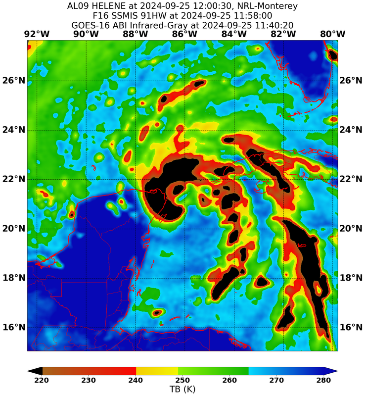
ATL: HELENE - Post-Tropical - Discussion

Moderator: S2k Moderators

Message
Author
tolakram
Admin
Admin
Posts: 20012
Age: 62
Joined: Sun Aug 27, 2006 8:23 pm
Location: Florence, KY (name is Mark)

Re: ATL: HELENE - Hurricane - Discussion

#1641 Postby tolakram » Wed Sep 25, 2024 11:26 am

acidus wrote:Can you believe this guy?

Huge News! Helene Will Not Be A Major Hurricane On Landfall!
https://www.youtube.com/watch?v=GG3nS9ZAxZ4&lc


No, why would you? That was also 19 hours ago. He's making a forecast, he can be wrong, I judge forecasts based on track record and nothing else.

This is a good opportunity to remind people that you can find a lot of crazy things on social media. If you post it you own it, and if it violates S2K policy (the above does not) it could lead to a warning.

Also, if you are posting something that seems obviously off I would advise against it, or using the convenient disclaimer button in the post just to draw attention to something that might not be true.

The posts in this forum are NOT official forecasts and should not be used as such. They are just the opinion of the poster and may or may not be backed by sound meteorological data. They are NOT endorsed by any professional institution or STORM2K. For official information, please refer to products from the NHC and NWS.
4 likes   
M a r k
- - - - -
Join us in chat: Storm2K Chatroom Invite. Android and IOS apps also available.

The posts in this forum are NOT official forecasts and should not be used as such. Posts are NOT endorsed by any professional institution or STORM2K.org. For official information and forecasts, please refer to NHC and NWS products.

User avatar
jfk08c
S2K Supporter
S2K Supporter
Posts: 204
Joined: Mon Jun 11, 2018 4:36 pm
Location: Lakeland, FL

Re: ATL: HELENE - Hurricane - Discussion

#1642 Postby jfk08c » Wed Sep 25, 2024 11:28 am

acidus wrote:Can you believe this guy?

Huge News! Helene Will Not Be A Major Hurricane On Landfall!
https://www.youtube.com/watch?v=GG3nS9ZAxZ4&lc


The amount of weather YouTubers these days with clickbait thumbnails just spewing cliffnotes of what they've learned from others is alarming. Especially when they make bold claims to try and be different
4 likes   

User avatar
MGC
S2K Supporter
S2K Supporter
Posts: 5899
Joined: Sun Mar 23, 2003 9:05 pm
Location: Pass Christian MS, or what is left.

Re: ATL: HELENE - Hurricane - Discussion

#1643 Postby MGC » Wed Sep 25, 2024 11:28 am

Zonacane wrote:
Kingarabian wrote:Center is getting closer to the leading edge of the CDO so it probably means a temporary CCC is in place. Likely meaning that intensification could slow down for a few hours until the dry air is mixed out.

This is very wrong, there's a tongue of dry air getting wrapped in, but the intensity models show this getting mixed out very quickly. There is no shear or CCC developing. The dry slot makes the outline of the formative eye very obvious


I think that dry air will gradually mix out as the hurricane moves away from the Yucatan. Helene will be moving over the loop current which seems to be displaced to the east a bit. Should have high ocean heat content until Helene crosses the West Florida Escarpment......MGC
4 likes   

xironman
S2K Supporter
S2K Supporter
Posts: 2522
Joined: Sun Jun 10, 2007 4:53 pm
Location: NoVA

Re: ATL: HELENE - Hurricane - Discussion

#1644 Postby xironman » Wed Sep 25, 2024 11:28 am

The eye could almost be the size of the channel, you don't see that every day.
1 likes   

User avatar
acidus
Tropical Low
Tropical Low
Posts: 29
Joined: Tue Aug 31, 2004 3:10 pm
Location: Orlando, FL

Re: ATL: HELENE - Hurricane - Discussion

#1645 Postby acidus » Wed Sep 25, 2024 11:30 am

tolakram wrote:
acidus wrote:Can you believe this guy?

Huge News! Helene Will Not Be A Major Hurricane On Landfall!
https://www.youtube.com/watch?v=GG3nS9ZAxZ4&lc


No, why would you?

This is a good opportunity to remind people that you can find a lot of crazy things on social media. If you post it you own it, and if it violates S2K policy (the above does not) it could lead to a warning.

Also, if you are posting something that seems obviously off I would advise against it, or using the convenient disclaimer button in the post just to draw attention to something that might not be true.

The posts in this forum are NOT official forecasts and should not be used as such. They are just the opinion of the poster and may or may not be backed by sound meteorological data. They are NOT endorsed by any professional institution or STORM2K. For official information, please refer to products from the NHC and NWS.


I certainly don't believe him at all. NHC has it as a major hurricane, meteorologist Brian Shields saying strong Cat 3 or maybe Cat 4. And meteorologist Joe Bastardi posted on Twitter he thinks Cat 5. And there's some bozo telling people it will just be Cat 1 on YouTube. That is potentially life threatening.
1 likes   

User avatar
Kazmit
Category 5
Category 5
Posts: 2124
Age: 22
Joined: Mon Jul 25, 2016 8:49 am
Location: Williamsburg, VA / Bermuda

Re: ATL: HELENE - Hurricane - Discussion

#1646 Postby Kazmit » Wed Sep 25, 2024 11:31 am

jfk08c wrote:
acidus wrote:Can you believe this guy?

Huge News! Helene Will Not Be A Major Hurricane On Landfall!
https://www.youtube.com/watch?v=GG3nS9ZAxZ4&lc


The amount of weather YouTubers these days with clickbait thumbnails just spewing cliffnotes of what they've learned from others is alarming. Especially when they make bold claims to try and be different

What always annoys me are the thumbnails of an obviously photoshopped image of a past storm (usually a cat 5 or something) on top of the forecast track for the storm that the video is actually about.
4 likes   
Igor 2010, Sandy 2012, Fay 2014, Gonzalo 2014, Joaquin 2015, Nicole 2016, Humberto 2019

I am only a tropical weather enthusiast. My predictions are not official and may or may not be backed by sound meteorological data. For official information, please refer to the NHC and NWS products.

User avatar
Kingarabian
S2K Supporter
S2K Supporter
Posts: 15997
Joined: Sat Aug 08, 2009 3:06 am
Location: Honolulu, Hawaii

Re: ATL: HELENE - Hurricane - Discussion

#1647 Postby Kingarabian » Wed Sep 25, 2024 11:31 am

Large eye for sure. Still has some work to do to wall off the dry air so it can formally take off.

Image
2 likes   
RIP Kobe Bryant

tolakram
Admin
Admin
Posts: 20012
Age: 62
Joined: Sun Aug 27, 2006 8:23 pm
Location: Florence, KY (name is Mark)

Re: ATL: HELENE - Hurricane - Discussion

#1648 Postby tolakram » Wed Sep 25, 2024 11:34 am

acidus wrote:
tolakram wrote:
acidus wrote:Can you believe this guy?

Huge News! Helene Will Not Be A Major Hurricane On Landfall!
https://www.youtube.com/watch?v=GG3nS9ZAxZ4&lc


No, why would you?

This is a good opportunity to remind people that you can find a lot of crazy things on social media. If you post it you own it, and if it violates S2K policy (the above does not) it could lead to a warning.

Also, if you are posting something that seems obviously off I would advise against it, or using the convenient disclaimer button in the post just to draw attention to something that might not be true.

The posts in this forum are NOT official forecasts and should not be used as such. They are just the opinion of the poster and may or may not be backed by sound meteorological data. They are NOT endorsed by any professional institution or STORM2K. For official information, please refer to products from the NHC and NWS.


I certainly don't believe him at all. NHC has it as a major hurricane, meteorologist Brian Shields saying strong Cat 3 or maybe Cat 4. And meteorologist Joe Bastardi posted on Twitter he thinks Cat 5. And there's some bozo telling people it will just be Cat 1 on YouTube. That is potentially life threatening.


Many weather youtubers feeds look like this. Anyone serious about being informed should look at these videos and walk away, or at least understand this is NOT serious meteorology.
Image

This is all about getting the clicks and the ad revenue.
11 likes   
M a r k
- - - - -
Join us in chat: Storm2K Chatroom Invite. Android and IOS apps also available.

The posts in this forum are NOT official forecasts and should not be used as such. Posts are NOT endorsed by any professional institution or STORM2K.org. For official information and forecasts, please refer to NHC and NWS products.

Laser30033003
Tropical Depression
Tropical Depression
Posts: 52
Age: 55
Joined: Tue Aug 19, 2008 1:24 pm
Location: Seminole, Fl

Re: ATL: HELENE - Hurricane - Discussion

#1649 Postby Laser30033003 » Wed Sep 25, 2024 11:34 am

I'm just worried about her moving closer to Pinellas County... like a Charley turn and coming in farther east... I know that the models don't show this, but still a worry.
0 likes   

User avatar
eastcoastFL
Category 5
Category 5
Posts: 3901
Age: 43
Joined: Thu Apr 12, 2007 12:29 pm
Location: Palm City, FL

Re: ATL: HELENE - Hurricane - Discussion

#1650 Postby eastcoastFL » Wed Sep 25, 2024 11:35 am

Martin county schools will be closed tomorrow, Thursday the 26th.
0 likes   
Personal Forecast Disclaimer:
The posts in this forum are NOT official forecast and should not be used as such. They are just the opinion of the poster and may or may not be backed by sound meteorological data. They are NOT endorsed by any professional institution or storm2k.org. For official information, please refer to the NHC and NWS products.

wx98
Category 5
Category 5
Posts: 1383
Joined: Sat Aug 25, 2018 9:24 pm

Re: ATL: HELENE - Hurricane - Discussion

#1651 Postby wx98 » Wed Sep 25, 2024 11:36 am

hiflyer wrote:I guess we all remember Katrina 20 years ago…came off Florida weak and hit the loop current and went into New Orleans as a cat 5. Bringing it up as current forecast path has Helene staying close to it for a ways after riding past Yucatan/Cuba in it. That is a lot of deep warmer water to be near.

FWIW Katrina missed New Orleans to the east and was a Cat 3 at landfall…
4 likes   

User avatar
cycloneye
Admin
Admin
Posts: 145490
Age: 68
Joined: Thu Oct 10, 2002 10:54 am
Location: San Juan, Puerto Rico

Re: ATL: HELENE - Hurricane - Discussion

#1652 Postby cycloneye » Wed Sep 25, 2024 11:36 am

3 likes   
Visit the Caribbean-Central America Weather Thread where you can find at first post web cams,radars
and observations from Caribbean basin members Click Here

User avatar
HurricaneBelle
S2K Supporter
S2K Supporter
Posts: 1179
Joined: Sun Aug 27, 2006 6:12 pm
Location: Clearwater, FL

Re: ATL: HELENE - Hurricane - Discussion

#1653 Postby HurricaneBelle » Wed Sep 25, 2024 11:41 am

Laser30033003 wrote:I'm just worried about her moving closer to Pinellas County... like a Charley turn and coming in farther east... I know that the models don't show this, but still a worry.


Well you're never in the clear until the storm passes your latitude, but forecasting and modeling has come a long way in the 20 years since Charley so here in Clearwater I'm not really worried about it. And Tampa's hurricane-force wind probabilities have been decreasing from the teens yesterday to 2% with the 11AM advisory. Which is not to say we won't get a hurricane-force gust or two but the sustained winds should be in the 40s and 50s, still enough to do some damage and cause quite a few power outages.
4 likes   

User avatar
GCANE
S2K Supporter
S2K Supporter
Posts: 11500
Joined: Mon Oct 22, 2007 8:03 am

Re: ATL: HELENE - Hurricane - Discussion

#1654 Postby GCANE » Wed Sep 25, 2024 11:41 am

Looks like a new EPAC TPW feed is starting up across the IoT.

https://tropic.ssec.wisc.edu/real-time/ ... anim=html5

I don't think GFS and other models were forecasting this.
Could mean a higher intensity than current forecast.
7 likes   

User avatar
aspen
Category 5
Category 5
Posts: 8818
Joined: Sat Oct 12, 2019 7:10 pm
Location: Connecticut, USA

Re: ATL: HELENE - Hurricane - Discussion

#1655 Postby aspen » Wed Sep 25, 2024 11:42 am

The dry slot is getting quite pronounced on visible. Probably gonna take the rest of the day to mix out. Good news is that potentially lowers Helene’s ceiling…bad news is a delay in RI could mean RI-to-landfall like Michael.
0 likes   
Irene '11 Sandy '12 Hermine '16 5/15/2018 Derecho Fay '20 Isaias '20 Elsa '21 Henri '21 Ida '21

I am only a meteorology enthusiast who knows a decent amount about tropical cyclones. Look to the professional mets, the NHC, or your local weather office for the best information.

wx98
Category 5
Category 5
Posts: 1383
Joined: Sat Aug 25, 2018 9:24 pm

Re: ATL: HELENE - Hurricane - Discussion

#1656 Postby wx98 » Wed Sep 25, 2024 11:43 am

acidus wrote:Can you believe this guy? People listening to him could be putting their lives in danger!

Huge News! Helene Will Not Be A Major Hurricane On Landfall!
https://www.youtube.com/watch?v=GG3nS9ZAxZ4&lc

The posts in this forum are NOT official forecasts and should not be used as such. They are just the opinion of the poster and may or may not be backed by sound meteorological data. They are NOT endorsed by any professional institution or STORM2K. For official information, please refer to products from the NHC and NWS.


Having 85,000 views in one day for nonsense is concerning in a different aspect as well…
2 likes   

User avatar
chaser1
S2K Supporter
S2K Supporter
Posts: 5478
Age: 64
Joined: Sat Oct 15, 2005 5:59 pm
Location: Longwood, Fl

Re: ATL: HELENE - Hurricane - Discussion

#1657 Postby chaser1 » Wed Sep 25, 2024 11:44 am

Pipelines182 wrote:
chaser1 wrote:
Pipelines182 wrote:Judging from the satellite appearance, Helene is dealing with some wind shear, the CDO has become asymmetric. There's also signs of dry air entrainment, the CDO is warming and there's signs of thunderstorms collapsing with the outflow boundaries streaming off the southern and western sides. No RI for the time being.


I don't see that. Outflow is unrestricted and whatever pulsing of convection and cloud tops appear to me as nothing greater than part of the diurnal processes still at hand until the systems core is fully developed (getting close). I will say this though, there is a small upper level of dry air capping between 200mb and 300mb that might be slightly affecting the system's vertical vorticity where RH is showing to be only 40-50% within that layer (as depicted on the 6Z GFS vertical cross-section graphs - https://www.tropicaltidbits.com/analysi ... 92506&fh=1 ) from about Longitude 85.5 and points westward. I'm sure that NHC clearly sees that, and why RI is practically a given after the hurricane begins moving northward and especially as it begins motion east of due north.


If you look back to 12z you can see a large outflow boundary coming out of the CDO on the SW half, that's a sign of a large collapse of thunderstorms. The feathery cirrus outflow that's continuing is another sign of continued dry air entrainment. The diurnal process isn't that significant for hurricanes, and they don't cause drastic warming/cooling of the CDO in short time frames.


Feathery cirrus outflow is NOT a sign of dry air entrainment. Outflow boundaries indicative of collapsing CB's ARE a sign of dry air. In actuality the diurnal process is practically insignificant for any well developed or mature hurricane but where other conditions mitigate the hurricane from sustaining it's vertical structure the diurnal process can and will enhance the low-level convergence, updraft and vertical velocity, and ultimately upper air heat & energy dispersion. Helene is now a hurricane however still in the final stages of organization and remains short of having a very well-developed structure. That will change soon enough.
6 likes   
Andy D

(For official information, please refer to the NHC and NWS products.)

Sailingtime
Tropical Low
Tropical Low
Posts: 37
Joined: Thu Aug 29, 2019 7:02 pm

Re: ATL: HELENE - Hurricane - Discussion

#1658 Postby Sailingtime » Wed Sep 25, 2024 11:47 am

wx98 wrote:
hiflyer wrote:I guess we all remember Katrina 20 years ago…came off Florida weak and hit the loop current and went into New Orleans as a cat 5. Bringing it up as current forecast path has Helene staying close to it for a ways after riding past Yucatan/Cuba in it. That is a lot of deep warmer water to be near.

FWIW Katrina missed New Orleans to the east and was a Cat 3 at landfall…


New Orleans survived Katrina quite well actually. It was after the storm had passed when the insufficient levy system failed allowing storm water to enter the city. If the levy's would have held the disaster would have never happened other than normal hurricane damage.
8 likes   

Pipelines182
Tropical Storm
Tropical Storm
Posts: 159
Joined: Tue Jul 02, 2024 8:46 am

Re: ATL: HELENE - Hurricane - Discussion

#1659 Postby Pipelines182 » Wed Sep 25, 2024 11:50 am

aspen wrote:The dry slot is getting quite pronounced on visible. Probably gonna take the rest of the day to mix out. Good news is that potentially lowers Helene’s ceiling…bad news is a delay in RI could mean RI-to-landfall like Michael.

It could take a full 24 hours to get mixed out or longer, due to the size of the eye and it's current struggles I think C5 is already off the table, C4 will be next if it can't get the dry air out today. I don't think Helene can RI until landfall like Michael did, too much forward speed when it nears land. I think the best bet is a max of C3 with weakening near landfall to a low end C3/C2.
0 likes   

psyclone
S2K Supporter
S2K Supporter
Posts: 4769
Joined: Wed Aug 24, 2005 9:04 pm
Location: palm harbor fl

Re: ATL: HELENE - Hurricane - Discussion

#1660 Postby psyclone » Wed Sep 25, 2024 11:51 am

HurricaneBelle wrote:
Laser30033003 wrote:I'm just worried about her moving closer to Pinellas County... like a Charley turn and coming in farther east... I know that the models don't show this, but still a worry.


Well you're never in the clear until the storm passes your latitude, but forecasting and modeling has come a long way in the 20 years since Charley so here in Clearwater I'm not really worried about it. And Tampa's hurricane-force wind probabilities have been decreasing from the teens yesterday to 2% with the 11AM advisory. Which is not to say we won't get a hurricane-force gust or two but the sustained winds should be in the 40s and 50s, still enough to do some damage and cause quite a few power outages.


Those west shifts give us some breathing room...which we might need if things tick back east a bit. Folks in Pinellas on high ground should be good. Probably the biggest hazard here is surge related.
0 likes   


Return to “2024”

Who is online

Users browsing this forum: No registered users and 0 guests