ATL: HELENE - Models

Moderator: S2k Moderators

Message
Author
caneman
Category 5
Category 5
Posts: 1447
Joined: Fri Sep 05, 2014 5:44 am
Location: Clearwater Beach, Fl

Re: ATL: HELENE - Models

#781 Postby caneman » Wed Sep 25, 2024 7:19 pm

tolakram wrote:
caneman wrote:
gatorcane wrote:Latest 18Z GEFS ensembles, with a slight SE shift from the 12Z and east of the NHC track:
https://i.postimg.cc/Y2JmDJTR/gfs-ememb-lowlocs-watl-fh0-36.gif


I've noticed the same in previous storms. I'm not questioning the NHC'S ability but I am asking does that mean they've discounted these other models for one reason or another? Legit question.


I'm not sure, you could ask them. They still use the Florida State Super ensemble as far as I know, and it's skill blending various models has shown to be higher than individual models.


How could I really ask them? Are you being serious? It's just a curious question. Maybe they are relying on the FSU model. I have zero clue and just curious. I just don't know if sometimes they rely on one some models more than others for one reason or another. Maybe things have changed but I remember not so long ago when the Euro spoke people listened as an example. Wanting to learn and certainly not wanting to challenge them as they are almost always spot on. Maybe they are so skilled that they have more knowledge than models?
Last edited by caneman on Wed Sep 25, 2024 7:28 pm, edited 2 times in total.
0 likes   

User avatar
Bocadude85
Category 5
Category 5
Posts: 2991
Age: 38
Joined: Mon Apr 18, 2005 2:20 pm
Location: Honolulu,Hi

Re: ATL: HELENE - Models

#782 Postby Bocadude85 » Wed Sep 25, 2024 7:24 pm

gatorcane wrote:Latest 18Z GEFS ensembles, with a slight SE shift from the 12Z and east of the NHC track:
https://i.postimg.cc/Y2JmDJTR/gfs-ememb-lowlocs-watl-fh0-36.gif


Something to watch will be at which latitude Helene crosses east of longitude 86. The farther west models don’t show her crossing this until 25-26N.
2 likes   

User avatar
Steve
S2K Supporter
S2K Supporter
Posts: 9617
Joined: Sat Apr 05, 2003 11:41 pm
Location: Not a state-caster

Re: ATL: HELENE - Models

#783 Postby Steve » Wed Sep 25, 2024 7:28 pm

caneman wrote:
tolakram wrote:
caneman wrote:
I've noticed the same in previous storms. I'm not questioning the NHC'S ability but I am asking does that mean they've discounted these other models for one reason or another? Legit question.


I'm not sure, you could ask them. They still use the Florida State Super ensemble as far as I know, and it's skill blending various models has shown to be higher than individual models.


How could I really ask them? Are you being serious? It's just a curious question. Maybe they are relying on the FSU model. I have zero clue and just curious. I just don't know if sometimes they rely on one some models more than others for one reason or another. Maybe things have changed but I remember not so long ago when the Euro spoke people listened as an example. Wanting to learn and certainly not wanting to challenge them as they are almost always spot on. Maybe they are so skilled that they have more knowledge than models?


Send them an email or letter?
1 likes   

tolakram
Admin
Admin
Posts: 20009
Age: 62
Joined: Sun Aug 27, 2006 8:23 pm
Location: Florence, KY (name is Mark)

Re: ATL: HELENE - Models

#784 Postby tolakram » Wed Sep 25, 2024 7:30 pm

Steve wrote:
caneman wrote:
tolakram wrote:
I'm not sure, you could ask them. They still use the Florida State Super ensemble as far as I know, and it's skill blending various models has shown to be higher than individual models.


How could I really ask them? Are you being serious? It's just a curious question. Maybe they are relying on the FSU model. I have zero clue and just curious. I just don't know if sometimes they rely on one some models more than others for one reason or another. Maybe things have changed but I remember not so long ago when the Euro spoke people listened as an example. Wanting to learn and certainly not wanting to challenge them as they are almost always spot on. Maybe they are so skilled that they have more knowledge than models?


Send them an email or letter?


I forget who from here last asked them a question but I remember that they answered.
2 likes   
M a r k
- - - - -
Join us in chat: Storm2K Chatroom Invite. Android and IOS apps also available.

The posts in this forum are NOT official forecasts and should not be used as such. Posts are NOT endorsed by any professional institution or STORM2K.org. For official information and forecasts, please refer to NHC and NWS products.

caneman
Category 5
Category 5
Posts: 1447
Joined: Fri Sep 05, 2014 5:44 am
Location: Clearwater Beach, Fl

Re: ATL: HELENE - Models

#785 Postby caneman » Wed Sep 25, 2024 7:31 pm

Steve wrote:
caneman wrote:
tolakram wrote:
I'm not sure, you could ask them. They still use the Florida State Super ensemble as far as I know, and it's skill blending various models has shown to be higher than individual models.


How could I really ask them? Are you being serious? It's just a curious question. Maybe they are relying on the FSU model. I have zero clue and just curious. I just don't know if sometimes they rely on one some models more than others for one reason or another. Maybe things have changed but I remember not so long ago when the Euro spoke people listened as an example. Wanting to learn and certainly not wanting to challenge them as they are almost always spot on. Maybe they are so skilled that they have more knowledge than models?


Send them an email or letter?


You seriously can do that?
1 likes   

caneman
Category 5
Category 5
Posts: 1447
Joined: Fri Sep 05, 2014 5:44 am
Location: Clearwater Beach, Fl

Re: ATL: HELENE - Models

#786 Postby caneman » Wed Sep 25, 2024 7:32 pm

tolakram wrote:
Steve wrote:
caneman wrote:
How could I really ask them? Are you being serious? It's just a curious question. Maybe they are relying on the FSU model. I have zero clue and just curious. I just don't know if sometimes they rely on one some models more than others for one reason or another. Maybe things have changed but I remember not so long ago when the Euro spoke people listened as an example. Wanting to learn and certainly not wanting to challenge them as they are almost always spot on. Maybe they are so skilled that they have more knowledge than models?


Send them an email or letter?


I forget who from here last asked them a question but I remember that they answered.


Ok. Cool. My scientific part of my brain begs for an answer. Like things have to make sense. Lol
1 likes   

User avatar
MetsIslesNoles
S2K Supporter
S2K Supporter
Posts: 64
Joined: Thu Jul 07, 2005 10:42 pm
Location: Tallahassee, FL

Re: ATL: HELENE - Models

#787 Postby MetsIslesNoles » Wed Sep 25, 2024 7:43 pm

Anybody know why so many tv stations and social media account seem to be pushing the GRAF model. (What even is that?)
2 likes   

Slughitter3
Tropical Depression
Tropical Depression
Posts: 54
Age: 35
Joined: Wed Jul 10, 2013 1:16 pm
Location: Huntingtown, MD

Re: RE: Re: ATL: HELENE - Models

#788 Postby Slughitter3 » Wed Sep 25, 2024 7:44 pm

caneman wrote:
tolakram wrote:
Steve wrote:
Send them an email or letter?


I forget who from here last asked them a question but I remember that they answered.


Ok. Cool. My scientific part of my brain begs for an answer. Like things have to make sense. Lol
There's a good chance they'll answer you via social media as well. I've had some success with that method in the past.

Sent from my SM-S928U using Tapatalk
2 likes   
I'm a weather-loving Coastie.
This post is only an opinion not a forecast. Please refer to the NHC and local NWS offices for forecasts.

Shawn

jlauderdal
S2K Supporter
S2K Supporter
Posts: 7182
Joined: Wed May 19, 2004 5:46 am
Location: NE Fort Lauderdale
Contact:

Re: ATL: HELENE - Models

#789 Postby jlauderdal » Wed Sep 25, 2024 7:46 pm

MetsIslesNoles wrote:Anybody know why so many tv stations and social media account seem to be pushing the GRAF model. (What even is that?)
They are paying for access so they are going to use it and some of their competitors in the media are unhappy about it because its to the east.
5 likes   

caneman
Category 5
Category 5
Posts: 1447
Joined: Fri Sep 05, 2014 5:44 am
Location: Clearwater Beach, Fl

Re: ATL: HELENE - Models

#790 Postby caneman » Wed Sep 25, 2024 7:54 pm

MetsIslesNoles wrote:Anybody know why so many tv stations and social media account seem to be pushing the GRAF model. (What even is that?)


Where is it calling for landfall?
0 likes   

User avatar
ronjon
Category 5
Category 5
Posts: 4822
Joined: Fri Aug 19, 2005 5:17 pm
Location: Hernando Beach, FL

Re: ATL: HELENE - Models

#791 Postby ronjon » Wed Sep 25, 2024 7:56 pm

caneman wrote:
gatorcane wrote:Latest 18Z GEFS ensembles, with a slight SE shift from the 12Z and east of the NHC track:
https://i.postimg.cc/Y2JmDJTR/gfs-ememb-lowlocs-watl-fh0-36.gif


I've noticed the same in previous storms. I'm not questioning the NHC'S ability but I am asking does that mean they've discounted these other models for one reason or another? Legit question and would like a knowledgeable persons answer and not guess work.


Gatorcane makes a good point. And your observations Caneman are valid. Believe NHC had consistently tracked west for Debby which made landfall in Steinhachee. Now its way too early to say one way or the other how Helene will landfall. I had forgot NHC utilizes UKMET and the ensembles in addition to the big two: Euro and GFS. In any case, think we're in real time tracking mode now and specifically watching if the storm follows that NE track the first 24 hrs that GFS is projecting to maybe get a better handle on ultimate landfall.
1 likes   

User avatar
aspen
Category 5
Category 5
Posts: 8818
Joined: Sat Oct 12, 2019 7:10 pm
Location: Connecticut, USA

Re: ATL: HELENE - Models

#792 Postby aspen » Wed Sep 25, 2024 8:06 pm

18z hurricane models still show recovery over the next 6-12 hours and RI until landfall. Helene looks pretty roughed-up now — 2024’s Gulf dry air strikes again — but the chances for a Cat 4 landfall remain.
2 likes   
Irene '11 Sandy '12 Hermine '16 5/15/2018 Derecho Fay '20 Isaias '20 Elsa '21 Henri '21 Ida '21

I am only a meteorology enthusiast who knows a decent amount about tropical cyclones. Look to the professional mets, the NHC, or your local weather office for the best information.

User avatar
Steve
S2K Supporter
S2K Supporter
Posts: 9617
Joined: Sat Apr 05, 2003 11:41 pm
Location: Not a state-caster

Re: ATL: HELENE - Models

#793 Postby Steve » Wed Sep 25, 2024 8:11 pm

MetsIslesNoles wrote:Anybody know why so many tv stations and social media account seem to be pushing the GRAF model. (What even is that?)


It’s been a while since I read it but I think the weather company was some weather tech nerds who partnered with IBM and possibly NVDA technology to put together a physics oriented modeling solution that incorporated AI. I don’t think it’s an exclusively radar derived product your local weather station might have - like vipir or whatever. This is their words and not an independent 3rd party analysis. So it’s biased. But it’s interesting. And it’s also had some pretty decent successes over the last couple years and some head scratchers as well.

https://www.weathercompany.com/global-h ... recasting/

Here’s when it came out in 2018 with Weather Underground describing what it was supposed to be.

https://www.wunderground.com/cat6/IBM-I ... ting-Model
4 likes   

User avatar
gatorcane
S2K Supporter
S2K Supporter
Posts: 23691
Age: 47
Joined: Sun Mar 13, 2005 3:54 pm
Location: Boca Raton, FL

Re: ATL: HELENE - Models

#794 Postby gatorcane » Wed Sep 25, 2024 8:36 pm

The GFS at hour 24 shifted right but the landfall is still similar. It also shifted slightly right between the 12Z and 6Z. We may see a more NE track for some period of time tomorrow across the EGOM before it veers a bit more NNE. Again, the NHC isn't showing this but the GFS and ECMWF are both showing a period of time where it moves more NE than NNE, maybe it ends up a bit closer to the west coast of Florida as a result:

Image
0 likes   

Poonwalker
Category 1
Category 1
Posts: 270
Joined: Tue Sep 20, 2022 11:12 am

Re: ATL: HELENE - Models

#795 Postby Poonwalker » Wed Sep 25, 2024 8:44 pm

Sometimes NHC will explain their track decision in their discussions. They will give weight to models based on the previous trends. They are also privy to exactly what is being fed into these prior to the runs.
0 likes   

User avatar
Travorum
Category 1
Category 1
Posts: 406
Joined: Tue Sep 05, 2023 9:36 am
Location: Dunedin, FL

Re: ATL: HELENE - Models

#796 Postby Travorum » Wed Sep 25, 2024 8:48 pm

gatorcane wrote:The GFS at hour 24 shifted right but the landfall is still similar. It also shifted slightly right between the 12Z and 6Z. We may see a more NE track for some period of time tomorrow across the EGOM before it veers a bit more NNE. Again, the NHC isn't showing this but the GFS and ECMWF are both showing a period of time where it moves more NE than NNE, maybe it ends up a bit closer to the west coast of Florida as a result:

https://i.postimg.cc/bwdTGLmW/gfs-mslp-pcpn-watl-fh24-trend.gif


I'm not well versed in reading the steering currents, but it looks to me like on the 18z GFS the high pressure east of Florida doesn't build as far west in the short run, which allows the initial motion of Helene to head more to the northeast. After that, the ULL over the US builds more further to the southeast than in previous runs which pulls Helene further to the north. The overall effect of this ends up being that the more easterly trajectory through 24 hours is counteracted by the more northerly pull after that, and therefore the final landfall location doesn't change significantly.

A notable result of this, like you said, is that while the landfall location doesn't change significantly, the trajectory leading up to landfall reaches much closer to the west coast of Florida, possibly resulting in greater storm surge.
2 likes   

User avatar
gatorcane
S2K Supporter
S2K Supporter
Posts: 23691
Age: 47
Joined: Sun Mar 13, 2005 3:54 pm
Location: Boca Raton, FL

Re: ATL: HELENE - Models

#797 Postby gatorcane » Wed Sep 25, 2024 9:05 pm

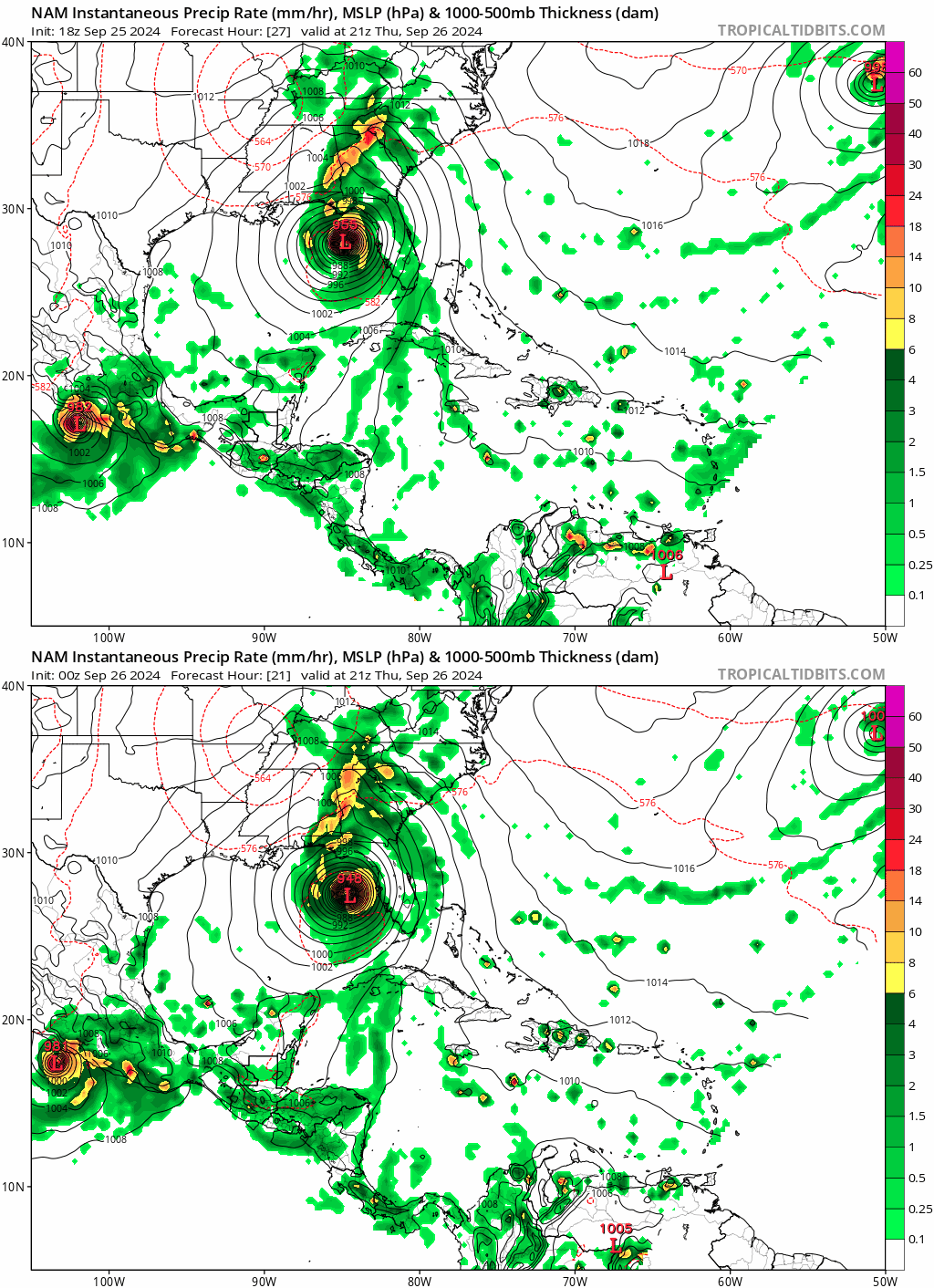
It's the NAM, but even it has shifted east, a bit closer to the west coast of Florida:
Image
0 likes   

redingtonbeach
Tropical Depression
Tropical Depression
Posts: 55
Joined: Mon Sep 04, 2017 12:05 am

Re: ATL: HELENE - Models

#798 Postby redingtonbeach » Wed Sep 25, 2024 9:09 pm

gatorcane wrote:It's the NAM, but even it has shifted east, a bit closer to the west coast of Florida:
https://i.postimg.cc/BbLDgZz0/nam-mslp-pcpn-watl-fh21-trend.gif


Like the NAM for track, especially the conus NAM.
0 likes   

CycloysisNegative
Tropical Low
Tropical Low
Posts: 12
Joined: Fri Jul 05, 2024 11:36 am
Location: Summerville, SC

Re: ATL: HELENE - Models

#799 Postby CycloysisNegative » Wed Sep 25, 2024 9:20 pm

What I noticed is there is a difference in the placement of the cutoff low between 12z/18z model runs. It’s further NW, not by a ton, but by around the same margin of the eastward shift. I would imagine being further away, its influence would decrease.
Last edited by CycloysisNegative on Wed Sep 25, 2024 9:25 pm, edited 1 time in total.
0 likes   

TampaWxLurker
Tropical Depression
Tropical Depression
Posts: 99
Joined: Thu Aug 01, 2024 8:20 am

Re: ATL: HELENE - Models

#800 Postby TampaWxLurker » Wed Sep 25, 2024 9:21 pm

These models showing a right nudge are interesting. Maybe the start of a trend. Let's see if it can thread the needle.

Head just slightly east of track, not far enough for major rises in predicted surge for the Tampa Bay area, but just far enough east that it ends up coming onshore where Tallahassee ends up on the western side and doesn't get the worst of it. Coming onshore in the vicinity of the mouth of the Aucillla River.
2 likes   


Return to “2024”

Who is online

Users browsing this forum: No registered users and 3 guests