
ATL: HELENE - Post-Tropical - Discussion
Moderator: S2k Moderators
-
tropicwatch

- Category 5

- Posts: 3426
- Age: 62
- Joined: Sat Jun 02, 2007 10:01 am
- Location: Panama City Florida
- Contact:
Re: ATL: HELENE - Hurricane - Discussion
Spaghetti models are indicating that Helene might start making its little westward turn before it makes landfall.
0 likes
Tropicwatch
Agnes 72', Eloise 75, Elena 85', Kate 85', Charley 86', Florence 88', Beryl 94', Dean 95', Erin 95', Opal 95', Earl 98', Georges 98', Ivan 2004', Arlene 2005', Dennis 2005', Ida 2009' Debby 2012' Irma 2017' Michael 2018'
Agnes 72', Eloise 75, Elena 85', Kate 85', Charley 86', Florence 88', Beryl 94', Dean 95', Erin 95', Opal 95', Earl 98', Georges 98', Ivan 2004', Arlene 2005', Dennis 2005', Ida 2009' Debby 2012' Irma 2017' Michael 2018'
-
eastcoastFL

- Category 5
- Posts: 3996
- Age: 44
- Joined: Thu Apr 12, 2007 12:29 pm
- Location: Palm City, FL
Re: ATL: HELENE - Hurricane - Discussion
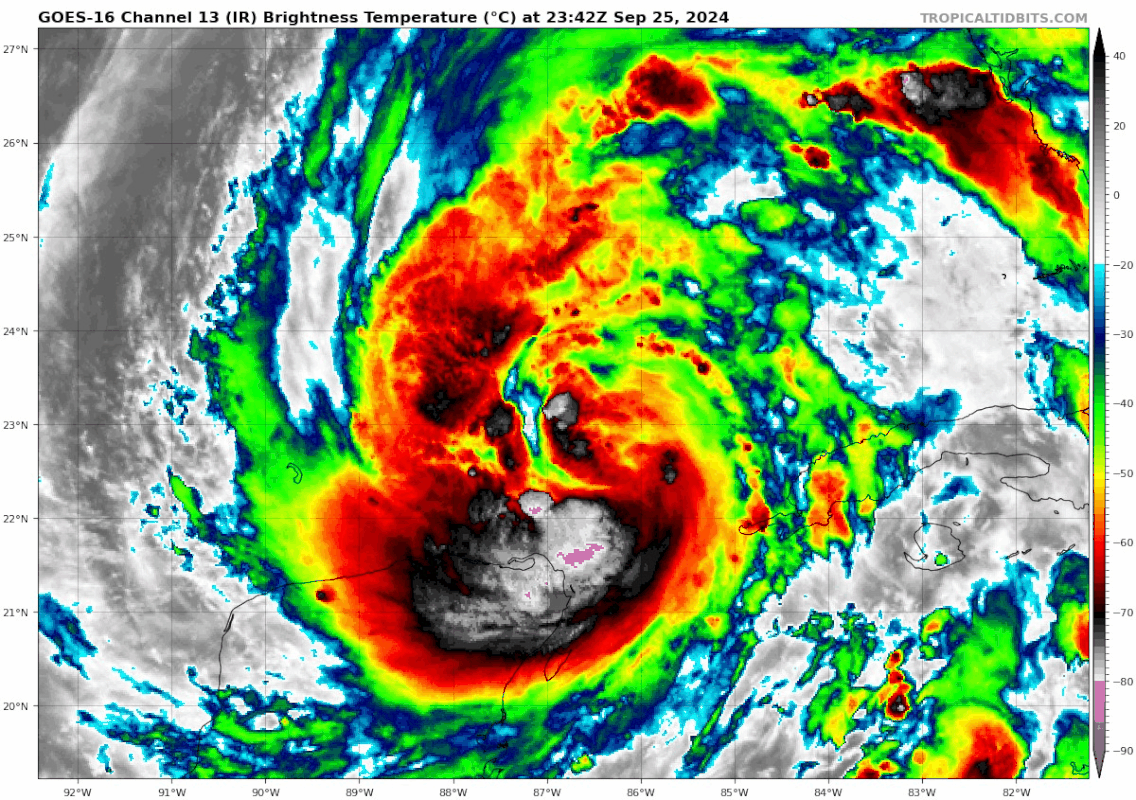
Looks like the eye is starting to close off

5 likes
Personal Forecast Disclaimer:
The posts in this forum are NOT official forecast and should not be used as such. They are just the opinion of the poster and may or may not be backed by sound meteorological data. They are NOT endorsed by any professional institution or storm2k.org. For official information, please refer to the NHC and NWS products.
The posts in this forum are NOT official forecast and should not be used as such. They are just the opinion of the poster and may or may not be backed by sound meteorological data. They are NOT endorsed by any professional institution or storm2k.org. For official information, please refer to the NHC and NWS products.

Re: RE: Re: RE: Re: RE: Re: ATL: HELENE - Hurricane - Discussion
eastcoastFL wrote:ObsessedMiami wrote:jlauderdal wrote:Thanks everyone, Dade is the only public school system open in Florida tomorrow, it could change.
I just don’t see it. Betty Davis was just on Channel 10 here predicting 45-55 mph gusts at noon tomorrow across Miami. I don’t see how they can justify being open during dismissal
A lot of parents will probably keep their kids home tomorrow. I work in palm beach and everyone already decided their kids were going to be home tomorrow before they announced closures this afternoon.
So irresponsible for Dade County to be the only county in the state open tomorrow.
If they do get TS Force winds they will exceed what most counties allow a school bus to operate in.
Dumb..
4 likes
Personal Forecast Disclaimer:
My posts are just my opinion and are most likely not backed by sound meteorological data. They are NOT endorsed by any professional institution or storm2k.org. For official information, please refer to the NHC and NWS products.
Bottom line is that I am just expressing my opinion!!!
My posts are just my opinion and are most likely not backed by sound meteorological data. They are NOT endorsed by any professional institution or storm2k.org. For official information, please refer to the NHC and NWS products.
Bottom line is that I am just expressing my opinion!!!

Re: ATL: HELENE - Hurricane - Discussion
eastcoastFL wrote:Looks like the eye is starting to close off
https://tropic.ssec.wisc.edu/real-time/mimtc/2024_09L/web/gifsBy12hr_02.gif
You can tell how the Yucatan really slowed it down. Some of the HAFS solutions where it really bottomed out had it with a smaller core. However, the HWRF and HMON had a larger core, so it deepened but not as much. Seems like the HWRF and HMON solutions are more accurate at the moment.
1 likes
-
gatorcane

- S2K Supporter

- Posts: 23708
- Age: 48
- Joined: Sun Mar 13, 2005 3:54 pm
- Location: Boca Raton, FL
Re: ATL: HELENE - Hurricane - Discussion
Pompano Beach Airpark recently reported a 49mph wind gust.
0 likes
-
jlauderdal
- S2K Supporter
- Posts: 7240
- Joined: Wed May 19, 2004 5:46 am
- Location: NE Fort Lauderdale
- Contact:
Re: RE: Re: RE: Re: RE: Re: RE: Re: ATL: HELENE - Hurricane - Discussion
We just had a 55 mph gust at FLL.ObsessedMiami wrote:jlauderdal wrote:Thanks everyone, Dade is the only public school system open in Florida tomorrow, it could change.Majek wrote:Escambia and Santa Rosa are the western most counties in Florida. Schools in both counties are closed tomorrow.
I just don’t see it. Betty Davis was just on Channel 10 here predicting 45-55 mph gusts at noon tomorrow across Miami. I don’t see how they can justify being open during dismissal
1 likes
-
cycloneye

- Admin

- Posts: 149160
- Age: 69
- Joined: Thu Oct 10, 2002 10:54 am
- Location: San Juan, Puerto Rico
Re: ATL: HELENE - Hurricane - Discussion
4 likes
Visit the Caribbean-Central America Weather Thread where you can find at first post web cams,radars
and observations from Caribbean basin members Click Here
and observations from Caribbean basin members Click Here
-
eastcoastFL
- Category 5
- Posts: 3996
- Age: 44
- Joined: Thu Apr 12, 2007 12:29 pm
- Location: Palm City, FL
Re: ATL: HELENE - Hurricane - Discussion
wzrgirl1 wrote:wzrgirl1 wrote:underthwx wrote:That may change tho.....this is an evolving event....impacts will be widespread unfortunately....im not sure how these school districts make decisions...regarding Helene....but im sure they are being advised by many agencies.....
The decision won't change unless it is a drastic change. I work for Miami-Dade County Public Schools and the superintendent met with Broward's superintendent and they made the decision together. I also am a union representative and we pushed for it but it was a no. The only thing that changed is that outdoor events are to be moved indoors.
So much for the joint statement. Now Broward is closed and Dade remains open. SMH
I thought that was interesting too. Not too long after I read that I see broward is closing. Whoever the dade superintendent is, they now stand alone.
3 likes
Personal Forecast Disclaimer:
The posts in this forum are NOT official forecast and should not be used as such. They are just the opinion of the poster and may or may not be backed by sound meteorological data. They are NOT endorsed by any professional institution or storm2k.org. For official information, please refer to the NHC and NWS products.
The posts in this forum are NOT official forecast and should not be used as such. They are just the opinion of the poster and may or may not be backed by sound meteorological data. They are NOT endorsed by any professional institution or storm2k.org. For official information, please refer to the NHC and NWS products.
Re: ATL: HELENE - Hurricane - Discussion
https://www.tropicaltidbits.com/stormin ... latest.png
so...is this good news? meaning...not quite as intense?
so...is this good news? meaning...not quite as intense?
0 likes
Re: ATL: HELENE - Tropical Storm - Discussion
rigbyrigz wrote:The upgraded Tallahassee NWS regional forecasts are now out... of 15 sections the worst one is PERRY:
For: Inland Taylor County
...HURRICANE WARNING REMAINS IN EFFECT...
* LOCATIONS AFFECTED
- Perry
* WIND
- LATEST LOCAL FORECAST: Equivalent Cat 2 Hurricane
force wind
- Peak Wind Forecast: 80-100 mph with gusts to
120 mph
Sorry if this isn't interesting to many but I find it mindboggling despite decades of Florida storms. (Above is last nite 11PM upd.)
The excerpt below is the LATEST for Perry (Inland Taylor County). My Florida weather resource (Linda Somers) says it's due to a wee nudge westward of expected landfall. OFC could nudge back(timing is everything, and models are so-so?) Just amazes me what a difference 50 miles of landfall can make, despite all the experts saying don't let that fool you for such a big storm. Comments?
Helene Local Watch/Warning Statement/Intermediate Advisory Number 9A
National Weather Service Tallahassee FL AL092024
205 PM EDT Wed Sep 25 2024
FLZ028-260215-
/O.CON.KTAE.HU.W.1009.000000T0000Z-000000T0000Z/
Inland Taylor-
205 PM EDT Wed Sep 25 2024
...HURRICANE WARNING REMAINS IN EFFECT...
* LOCATIONS AFFECTED
- Perry
* WIND
- LATEST LOCAL FORECAST: Equivalent Tropical Storm force wind
- Peak Wind Forecast: 30-40 mph with gusts to 55 mph
- Window for Tropical Storm force winds: Thursday afternoon
until early Friday morning
0 likes
-
sicktght311
- Tropical Depression

- Posts: 86
- Joined: Thu Sep 02, 2010 11:31 am
Re: ATL: HELENE - Hurricane - Discussion
GTStorm wrote:https://www.tropicaltidbits.com/storminfo/09L_intensity_latest.png
so...is this good news? meaning...not quite as intense?
Look at the 24hr portion. Cat 3 likely. Probably still Cat 4+ tho
Last edited by sicktght311 on Wed Sep 25, 2024 8:05 pm, edited 1 time in total.
0 likes
-
canetracker

- S2K Supporter
- Posts: 751
- Age: 63
- Joined: Wed Jul 27, 2005 8:49 pm
- Location: Suburbia New Orleans...Harahan, LA
Re: ATL: HELENE - Hurricane - Discussion
Prof wrote:I have friends just west of Gainesville who are trying to decide whether to go more east. I can’t seem to find clear weather info for that area. Does anyone know what to expect around the Newberry/Archer area?
This is the wind gust model from the 18z GFS. Hope this helps.
2 likes
-
CycloysisNegative
- Tropical Low

- Posts: 28
- Joined: Fri Jul 05, 2024 11:36 am
- Location: Summerville, SC
Re: ATL: HELENE - Hurricane - Discussion
eastcoastFL wrote:Looks like the eye is starting to close off
https://tropic.ssec.wisc.edu/real-time/mimtc/2024_09L/web/gifsBy12hr_02.gif
Link to this product?
0 likes
Re: ATL: HELENE - Hurricane - Discussion
canetracker wrote:Prof wrote:I have friends just west of Gainesville who are trying to decide whether to go more east. I can’t seem to find clear weather info for that area. Does anyone know what to expect around the Newberry/Archer area?
This is the wind gust model from the 18z GFS. Hope this helps.
https://imgur.com/7K8UgUD
Which would be problematic for the west coast, except NHC isn't going by gfs and has it considerably further west
Is there any places that shows nhc model vs actual eye location? i know after 2am it should show up on https://www.sfwmd.gov/weather-radar/cur ... conditions
1 likes

Re: ATL: HELENE - Hurricane - Discussion
Almost calm in St. Petersburg now. One squall line came through late afternoon. Looks like the next band might work its way up from near Charlotte Harbor now, and on radar Broward is getting the east end of that band. For us, looks like a big dry/clear area after that, with almost no storm cloud tops.
Anybody on Treasure Island, St. Pete beach, Gulfport, if you're not 20'+ elevation and out of Zone A should be getting out. Evac orders for mobile homes and all of zone A have been going off on my phone since this morning. The last hurricane flooded Gulfport within an inch of the floor of O'Malley's, that had to be at about 5' on Beach drive. I'm thinking Helene could push a lot more if it cranks up overnight.
======================================================
DISCLAIMER: Not an expert! Always consult the NHC, local NWS
and local authorities. Heed evacuation warnings!
-----------------------------------------------------------------------------
0 likes
-
gatorcane
- S2K Supporter
- Posts: 23708
- Age: 48
- Joined: Sun Mar 13, 2005 3:54 pm
- Location: Boca Raton, FL
Re: ATL: HELENE - Hurricane - Discussion
canetracker wrote:Prof wrote:I have friends just west of Gainesville who are trying to decide whether to go more east. I can’t seem to find clear weather info for that area. Does anyone know what to expect around the Newberry/Archer area?
This is the wind gust model from the 18z GFS. Hope this helps.
https://imgur.com/7K8UgUD
Looks like wind gusts in the 70-80mph range for portions of West-Central Florida and the Tampa Bay area.
1 likes

Re: ATL: HELENE - Hurricane - Discussion
3 likes
TC naming lists: retirements and intensity
Most aggressive Advisory #1's in North Atlantic (cr. kevin for starting the list)
Most aggressive Advisory #1's in North Atlantic (cr. kevin for starting the list)
-
ScottNAtlanta

- Category 5
- Posts: 2535
- Joined: Sat May 25, 2013 3:11 pm
- Location: Atlanta, GA
Re: ATL: HELENE - Hurricane - Discussion
Looking at the satellite, when the eye finally opens up, it will be very large
1 likes
The posts in this forum are NOT official forecast and should not be used as such. They are just the opinion of the poster and may or may not be backed by sound meteorological data. They are NOT endorsed by any professional institution or storm2k.org. For official information, please refer to the NHC and NWS products.
-
sicktght311
- Tropical Depression
- Posts: 86
- Joined: Thu Sep 02, 2010 11:31 am
Re: ATL: HELENE - Hurricane - Discussion
Say what you want about the NAM, but it never fails to produce nightmare fuel

5 likes
-
canetracker
- S2K Supporter
- Posts: 751
- Age: 63
- Joined: Wed Jul 27, 2005 8:49 pm
- Location: Suburbia New Orleans...Harahan, LA
Re: ATL: HELENE - Hurricane - Discussion
LandoWill wrote:canetracker wrote:Prof wrote:I have friends just west of Gainesville who are trying to decide whether to go more east. I can’t seem to find clear weather info for that area. Does anyone know what to expect around the Newberry/Archer area?
This is the wind gust model from the 18z GFS. Hope this helps.
https://imgur.com/7K8UgUD
Which would be problematic for the west coast, except NHC isn't going by gfs and has it considerably further west
Is there any places that shows nhc model vs actual eye location? i know after 2am it should show up on https://www.sfwmd.gov/weather-radar/cur ... conditions
You can use zoom earth to track the eye vs the NHC track: https://zoom.earth/storms/helene-2024/#overlays=radar,crosshair
Also, the only global model that I can find that goes as far west as the NHC says it will is the CMC:
1 likes
Who is online
Users browsing this forum: No registered users and 62 guests