ATL: HELENE - Post-Tropical - Discussion

Moderator: S2k Moderators

Message
Author
User avatar
aspen
Category 5
Category 5
Posts: 8819
Joined: Sat Oct 12, 2019 7:10 pm
Location: Connecticut, USA

Re: ATL: HELENE - Hurricane - Discussion

#1981 Postby aspen » Wed Sep 25, 2024 8:36 pm

InfernoFlameCat wrote:
Cunxi Huang wrote:Uh, not a healthy structure.

https://i.imgur.com/35VEa1h.png

That is quite a healthy structure. Most of an eyewall is complete. IMHO

That’s a very large eye, still with an opening for dry air to sneak in (and IR suggests it’s still dealing with dry air). Would be a tough structure to get any RI from.

It’s crazy to think how the Gulf has had so many systems this year, yet all of them have struggled to varying degrees. All four of the Gulf hurricanes have had significant issues with even brief land interaction and/or dry air entrainment. Goes to show how SSTs aren’t everything (even though they can theoretically support a Rita 2.0 this year).
2 likes   
Irene '11 Sandy '12 Hermine '16 5/15/2018 Derecho Fay '20 Isaias '20 Elsa '21 Henri '21 Ida '21

I am only a meteorology enthusiast who knows a decent amount about tropical cyclones. Look to the professional mets, the NHC, or your local weather office for the best information.

User avatar
MetroMike
Category 4
Category 4
Posts: 952
Joined: Sun Aug 29, 2004 8:13 pm
Location: Tampa Bay
Contact:

Re: ATL: HELENE - Hurricane - Discussion

#1982 Postby MetroMike » Wed Sep 25, 2024 8:37 pm

canetracker wrote:
LandoWill wrote:
canetracker wrote:This is the wind gust model from the 18z GFS. Hope this helps.
https://imgur.com/7K8UgUD

Which would be problematic for the west coast, except NHC isn't going by gfs and has it considerably further west

Is there any places that shows nhc model vs actual eye location? i know after 2am it should show up on https://www.sfwmd.gov/weather-radar/cur ... conditions


You can use zoom earth to track the eye vs the NHC track: https://zoom.earth/storms/helene-2024/#overlays=radar,crosshair

Also, the only global model that I can find that goes as far west as the NHC says it will is the CMC:
https://imgur.com/bVYFnjt


My local TV mets would not agree with that wind depiction for Tampa
0 likes   

Michele B
S2K Supporter
S2K Supporter
Posts: 1114
Joined: Thu Aug 25, 2016 8:08 am
Location: SWFL

Re: ATL: HELENE - Hurricane - Discussion

#1983 Postby Michele B » Wed Sep 25, 2024 8:38 pm

Recurve wrote:Almost calm in St. Petersburg now. One squall line came through late afternoon. Looks like the next band might work its way up from near Charlotte Harbor now, and on radar Broward is getting the east end of that band. For us, looks like a big dry/clear area after that, with almost no storm cloud tops.

Anybody on Treasure Island, St. Pete beach, Gulfport, if you're not 20'+ elevation and out of Zone A should be getting out. Evac orders for mobile homes and all of zone A have been going off on my phone since this morning. The last hurricane flooded Gulfport within an inch of the floor of O'Malley's, that had to be at about 5' on Beach drive. I'm thinking Helene could push a lot more if it cranks up overnight.

======================================================
DISCLAIMER: Not an expert! Always consult the NHC, local NWS
and local authorities. Heed evacuation warnings!
-----------------------------------------------------------------------------


Anybody know when is high tide tomorrow near St. Pete area?
0 likes   
Cleo - 1964, Betsy - 1965, David - 1979, Andrew - 1992, Charlie (Francis, Ivan, Jeanne) - 2004, Irma - 2017, Ian - 2022

User avatar
Kingarabian
S2K Supporter
S2K Supporter
Posts: 16015
Joined: Sat Aug 08, 2009 3:06 am
Location: Honolulu, Hawaii

Re: ATL: HELENE - Hurricane - Discussion

#1984 Postby Kingarabian » Wed Sep 25, 2024 8:40 pm

Kingarabian wrote:Center is getting closer to the leading edge of the CDO so it probably means a temporary CCC is in place. Likely meaning that intensification could slow down for a few hours until the dry air is mixed out.


While the Cold Cast Cover (CCC) feature is gone, it's always an important satellite observation. That being said, as long as shear is low systems that undergo that feature can recover and become potent systems.
2 likes   
RIP Kobe Bryant

tolakram
Admin
Admin
Posts: 20012
Age: 62
Joined: Sun Aug 27, 2006 8:23 pm
Location: Florence, KY (name is Mark)

Re: ATL: HELENE - Hurricane - Discussion

#1985 Postby tolakram » Wed Sep 25, 2024 8:41 pm

Low level WV loop. A simple objective measurement is green vs blue, and green is on the increase near the center. I think.

Image

source: https://weather.cod.edu/satrad/?parms=m ... =undefined
6 likes   
M a r k
- - - - -
Join us in chat: Storm2K Chatroom Invite. Android and IOS apps also available.

The posts in this forum are NOT official forecasts and should not be used as such. Posts are NOT endorsed by any professional institution or STORM2K.org. For official information and forecasts, please refer to NHC and NWS products.

weathernet
Tropical Wave
Tropical Wave
Posts: 8
Joined: Sat Jun 23, 2012 3:16 pm
Location: TampaBay Florida

Re: ATL: HELENE - Hurricane - Discussion

#1986 Postby weathernet » Wed Sep 25, 2024 8:42 pm

Michele B wrote:
Recurve wrote:Almost calm in St. Petersburg now. One squall line came through late afternoon. Looks like the next band might work its way up from near Charlotte Harbor now, and on radar Broward is getting the east end of that band. For us, looks like a big dry/clear area after that, with almost no storm cloud tops.

Anybody on Treasure Island, St. Pete beach, Gulfport, if you're not 20'+ elevation and out of Zone A should be getting out. Evac orders for mobile homes and all of zone A have been going off on my phone since this morning. The last hurricane flooded Gulfport within an inch of the floor of O'Malley's, that had to be at about 5' on Beach drive. I'm thinking Helene could push a lot more if it cranks up overnight.

======================================================
DISCLAIMER: Not an expert! Always consult the NHC, local NWS
and local authorities. Heed evacuation warnings!
-----------------------------------------------------------------------------


Anybody know when is high tide tomorrow near St. Pete area?


Next Tide State HIGH TIDE in Saint Pete Beach is at 7:19AM.
0 likes   
Tim

User avatar
canetracker
S2K Supporter
S2K Supporter
Posts: 751
Age: 62
Joined: Wed Jul 27, 2005 8:49 pm
Location: Suburbia New Orleans...Harahan, LA

Re: ATL: HELENE - Hurricane - Discussion

#1987 Postby canetracker » Wed Sep 25, 2024 8:42 pm

MetroMike wrote:
canetracker wrote:
LandoWill wrote:Which would be problematic for the west coast, except NHC isn't going by gfs and has it considerably further west

Is there any places that shows nhc model vs actual eye location? i know after 2am it should show up on https://www.sfwmd.gov/weather-radar/cur ... conditions


You can use zoom earth to track the eye vs the NHC track: https://zoom.earth/storms/helene-2024/#overlays=radar,crosshair

Also, the only global model that I can find that goes as far west as the NHC says it will is the CMC:
https://imgur.com/bVYFnjt


My local TV mets would not agree with that wind depiction for Tampa


Right. That's just model depictions of wind gusts to get a general idea of what may happen. Always best to follow the local guys and the NHC.
1 likes   

tolakram
Admin
Admin
Posts: 20012
Age: 62
Joined: Sun Aug 27, 2006 8:23 pm
Location: Florence, KY (name is Mark)

Re: ATL: HELENE - Hurricane - Discussion

#1988 Postby tolakram » Wed Sep 25, 2024 8:43 pm

3 likes   
M a r k
- - - - -
Join us in chat: Storm2K Chatroom Invite. Android and IOS apps also available.

The posts in this forum are NOT official forecasts and should not be used as such. Posts are NOT endorsed by any professional institution or STORM2K.org. For official information and forecasts, please refer to NHC and NWS products.

PavelGaborik10
Category 1
Category 1
Posts: 455
Joined: Tue Sep 04, 2018 3:23 pm

Re: ATL: HELENE - Hurricane - Discussion

#1989 Postby PavelGaborik10 » Wed Sep 25, 2024 8:44 pm

Looks to finally be fighting off the dry air, though it's tried and failed in this very spot before earlier today.

With 24 hours to go before landfall every hour counts, it's hard not to be pleased that this is still a category 1 hurricane at the moment.
5 likes   

User avatar
ConvergenceZone
Category 5
Category 5
Posts: 5194
Joined: Fri Jul 29, 2005 1:40 am
Location: Northern California

Re: ATL: HELENE - Hurricane - Discussion

#1990 Postby ConvergenceZone » Wed Sep 25, 2024 8:50 pm

aspen wrote:
InfernoFlameCat wrote:
Cunxi Huang wrote:Uh, not a healthy structure.

https://i.imgur.com/35VEa1h.png

That is quite a healthy structure. Most of an eyewall is complete. IMHO

That’s a very large eye, still with an opening for dry air to sneak in (and IR suggests it’s still dealing with dry air). Would be a tough structure to get any RI from.

It’s crazy to think how the Gulf has had so many systems this year, yet all of them have struggled to varying degrees. All four of the Gulf hurricanes have had significant issues with even brief land interaction and/or dry air entrainment. Goes to show how SSTs aren’t everything (even though they can theoretically support a Rita 2.0 this year).


well we will see, maybe those who mentioned dry air were right and perhaps it might have a hard time getting past high end cat 1 or cat 2. But I guess only time will tell.
0 likes   

User avatar
cheezyWXguy
Category 5
Category 5
Posts: 6108
Joined: Mon Feb 13, 2006 12:29 am
Location: Dallas, TX

Re: ATL: HELENE - Hurricane - Discussion

#1991 Postby cheezyWXguy » Wed Sep 25, 2024 8:51 pm

With regard to appearance, remember to focus on the trend over time, and not on what it looks like in this moment in a vacuum. While still fragmented, convection in the core is substantially deeper than it was a few hours ago. If this trend continues, it’s likely we will be waking up to a storm that even the naysayers will acknowledge is prettier.
6 likes   


User avatar
eastcoastFL
Category 5
Category 5
Posts: 3901
Age: 43
Joined: Thu Apr 12, 2007 12:29 pm
Location: Palm City, FL

Re: ATL: HELENE - Hurricane - Discussion

#1993 Postby eastcoastFL » Wed Sep 25, 2024 8:52 pm

The two recon flights look like they’re about to cross paths.
0 likes   
Personal Forecast Disclaimer:
The posts in this forum are NOT official forecast and should not be used as such. They are just the opinion of the poster and may or may not be backed by sound meteorological data. They are NOT endorsed by any professional institution or storm2k.org. For official information, please refer to the NHC and NWS products.

User avatar
ObsessedMiami
Category 1
Category 1
Posts: 431
Joined: Tue Aug 31, 2004 8:08 pm
Location: West Kendall, Fl

Re: ATL: HELENE - Hurricane - Discussion

#1994 Postby ObsessedMiami » Wed Sep 25, 2024 8:53 pm

I have relatives in Liberty County, where the center of the cone tracks, and the Liberty County EMS ordered a mandatory evacuation of all residences in the county as of noon tomorrow. Not unsafe structures. All of them

ATTENTION ALL LIBERTY COUNTY RESIDENTS

We are now expecting a Category 4 or stronger hurricane to impact us. For your safety, we are ordering a MANDATORY EVACUATION no later than 12:00 noon on Thursday, September 26th.

*Secure your property if time allows
* Follow designated evacuation routes
* If you need assistance, please contact local authorities first thing in the morning
* Stay tuned to officials for updates

Your safety is our priority. Please evacuate!
Last edited by ObsessedMiami on Wed Sep 25, 2024 8:58 pm, edited 1 time in total.
0 likes   

Poonwalker
Category 1
Category 1
Posts: 270
Joined: Tue Sep 20, 2022 11:12 am

Re: ATL: HELENE - Hurricane - Discussion

#1995 Postby Poonwalker » Wed Sep 25, 2024 8:55 pm

Michele B wrote:
Recurve wrote:Almost calm in St. Petersburg now. One squall line came through late afternoon. Looks like the next band might work its way up from near Charlotte Harbor now, and on radar Broward is getting the east end of that band. For us, looks like a big dry/clear area after that, with almost no storm cloud tops.

Anybody on Treasure Island, St. Pete beach, Gulfport, if you're not 20'+ elevation and out of Zone A should be getting out. Evac orders for mobile homes and all of zone A have been going off on my phone since this morning. The last hurricane flooded Gulfport within an inch of the floor of O'Malley's, that had to be at about 5' on Beach drive. I'm thinking Helene could push a lot more if it cranks up overnight.

======================================================
DISCLAIMER: Not an expert! Always consult the NHC, local NWS
and local authorities. Heed evacuation warnings!
-----------------------------------------------------------------------------


Anybody know when is high tide tomorrow near St. Pete area?


From what I can tell the next high tide is around 6am and a low around 2 pm. Helene should be pushing the most surge around 4 pm tomorrow. That means it won’t be at a full high tide.
Last edited by Poonwalker on Wed Sep 25, 2024 9:18 pm, edited 2 times in total.
0 likes   

tolakram
Admin
Admin
Posts: 20012
Age: 62
Joined: Sun Aug 27, 2006 8:23 pm
Location: Florence, KY (name is Mark)

Re: ATL: HELENE - Hurricane - Discussion

#1996 Postby tolakram » Wed Sep 25, 2024 8:57 pm

Steady to starting to intensify.

Image

There is a comparison to Michael on X which took in some dry air as well before rapidly organizing the next day.

 https://x.com/HurricaneAddict/status/1839019333340770601

8 likes   
M a r k
- - - - -
Join us in chat: Storm2K Chatroom Invite. Android and IOS apps also available.

The posts in this forum are NOT official forecasts and should not be used as such. Posts are NOT endorsed by any professional institution or STORM2K.org. For official information and forecasts, please refer to NHC and NWS products.

User avatar
Kazmit
Category 5
Category 5
Posts: 2124
Age: 22
Joined: Mon Jul 25, 2016 8:49 am
Location: Williamsburg, VA / Bermuda

Re: ATL: HELENE - Hurricane - Discussion

#1997 Postby Kazmit » Wed Sep 25, 2024 8:58 pm
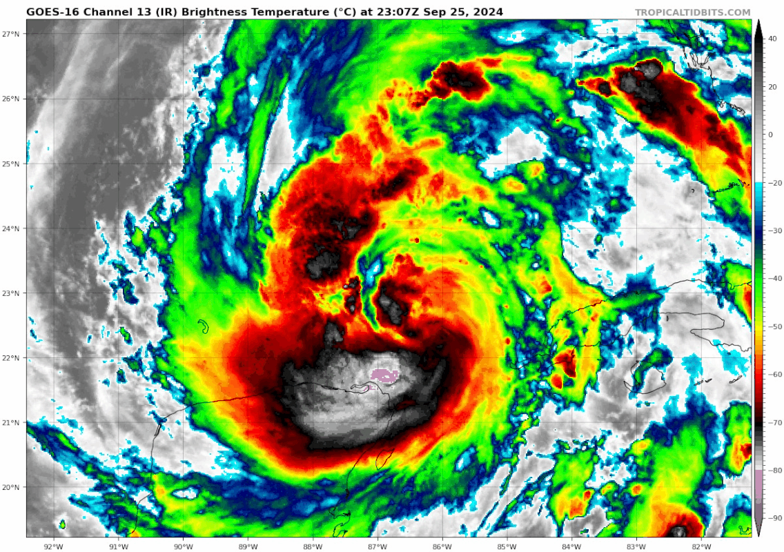
aspen wrote:
InfernoFlameCat wrote:
Cunxi Huang wrote:Uh, not a healthy structure.

https://i.imgur.com/35VEa1h.png

That is quite a healthy structure. Most of an eyewall is complete. IMHO

That’s a very large eye, still with an opening for dry air to sneak in (and IR suggests it’s still dealing with dry air). Would be a tough structure to get any RI from.

It’s crazy to think how the Gulf has had so many systems this year, yet all of them have struggled to varying degrees. All four of the Gulf hurricanes have had significant issues with even brief land interaction and/or dry air entrainment. Goes to show how SSTs aren’t everything (even though they can theoretically support a Rita 2.0 this year).

Dry air is the theme for this season. It may not be the inhibiting factor for genesis but it sure is for storms that already formed. In addition to the Gulf hurricanes, Ernesto also struggled with dry air which is why it never became a major. So that's every single hurricane of the season.
2 likes   
Igor 2010, Sandy 2012, Fay 2014, Gonzalo 2014, Joaquin 2015, Nicole 2016, Humberto 2019

I am only a tropical weather enthusiast. My predictions are not official and may or may not be backed by sound meteorological data. For official information, please refer to the NHC and NWS products.

User avatar
Teban54
Category 5
Category 5
Posts: 3208
Joined: Sat May 19, 2018 1:19 pm

Re: ATL: HELENE - Hurricane - Discussion

#1998 Postby Teban54 » Wed Sep 25, 2024 8:58 pm

tolakram wrote:Steady to starting to intensify.

https://i.imgur.com/d7ulCdR.png

There is a comparison to Michael on X which took in some dry air as well before rapidly organizing the next day.

 https://x.com/HurricaneAddict/status/1839019333340770601


Laura and Ida also "struggled" as Cat 1s when first entering the Gulf. People were saying very similar things to what's being said to Helene right now.
6 likes   

Powellrm
Tropical Storm
Tropical Storm
Posts: 102
Joined: Sun Sep 03, 2017 1:40 pm

Re: ATL: HELENE - Hurricane - Discussion

#1999 Postby Powellrm » Wed Sep 25, 2024 8:58 pm

ConvergenceZone wrote:
aspen wrote:
InfernoFlameCat wrote:That is quite a healthy structure. Most of an eyewall is complete. IMHO

That’s a very large eye, still with an opening for dry air to sneak in (and IR suggests it’s still dealing with dry air). Would be a tough structure to get any RI from.

It’s crazy to think how the Gulf has had so many systems this year, yet all of them have struggled to varying degrees. All four of the Gulf hurricanes have had significant issues with even brief land interaction and/or dry air entrainment. Goes to show how SSTs aren’t everything (even though they can theoretically support a Rita 2.0 this year).


well we will see, maybe those who mentioned dry air were right and perhaps it might have a hard time getting past high end cat 1 or cat 2. But I guess only time will tell.


Keep in mind, it’s still handling this quite well and is entering an environment that supports explosive intensification. Storms of this caliber will be just fine. It’s not entering anything that would prohibit RI. I also hope it chokes, but I am very much worried about the next stage. It’s good that it had ingested some dry air because I’d be worried about the potential if it had not, but many of the hurricane models had this dry air within the prognosis.
1 likes   

User avatar
Teban54
Category 5
Category 5
Posts: 3208
Joined: Sat May 19, 2018 1:19 pm

Re: ATL: HELENE - Hurricane - Discussion

#2000 Postby Teban54 » Wed Sep 25, 2024 9:01 pm

Also, imagine looking at this full loop and telling me this is not improving:

Image
8 likes   


Return to “2024”

Who is online

Users browsing this forum: No registered users and 152 guests