agreed. It’s clearly behind schedule now. I’ve been seeing posts for the last 24 hours saying “it’s about to take off any minute now.” It seems to have really leveled off and delayed its RI phase. The longer the better!.ConvergenceZone wrote:If you would have told me this morning that we would only be looking at an 85 mph tonight I would have been shocked. It's going to have to ramp up quick if it's going to make it from cat 1 to cat 4 in 17 hours. It's still possible , but from now on every hour it doesn't intensify lessons that chance of it landfalling as a cat 4.
ATL: HELENE - Post-Tropical - Discussion
Moderator: S2k Moderators
-
otowntiger
- Category 5

- Posts: 1932
- Joined: Tue Aug 31, 2004 7:06 pm
Re: ATL: HELENE - Hurricane - Discussion
Last edited by otowntiger on Thu Sep 26, 2024 1:51 am, edited 1 time in total.
2 likes
Re: ATL: HELENE - Hurricane - Discussion
rigbyrigz wrote:ThunderForce wrote:When is this supposed to start turning NNE/NE? NHC has said it's been moving north for quite a while now.
If you look at the Forecast discussion future-points over 36 hours, it moves almost due north for 12, then NNE* for 12, then almost due N for the last 12 hours. And the "outlooks" tend to say "north or north-northeast" but never says NE.
*in the second 12 hours actually moves up 4, right 1.5 = 69.4, when pure NNE is 67.5 ...just to show you it's on the North side of NNE.
Despite GFS and other models differing, these outlooks suggest landfall near St. Marks, abut 60 nm west of Perry area, where earlier landfall points in the discussions (and GFS etc) suggested. Due to eyewall aspects, that modification lowered the NWS local forecast for Perry (inland Taylor County) from 80-100 with gusts to 120, to 40-45 with gusts to 65. (So these things matter to the locals!!)
As some suggest, the large wind field means Perry could still bear 100+ horrors, and the coastal Taylor (Keaton Beach, Steinhatchee) indeed says 60-80 gusts to 100 (and has been rising over the day.)
Of course, slowing, front interaction timing, wobbles, and such could see this change. I've sought to see what experts (or hobbyists here) say abt this enduring difference in path (and landfall) from NHC official discussions, versus most of the models (besides CMC?) ...no one seems to have an answer, still seeking, lol!
According to my zoom earth app and assuming it's correct, it's been moving NNE for last few hours. I believe alot of times the intermediary updates are just a continuation of the regular updates. When you have ICON, GFS AND EURO agreeing on 30 or so miles more east that's pretty powerful so we'll have to wait til the 5 am update
0 likes
-
HurricaneRyan
- Category 3

- Posts: 844
- Age: 32
- Joined: Sun Dec 05, 2010 3:05 pm
Re: ATL: HELENE - Hurricane - Discussion
ElectricStorm wrote:ConvergenceZone wrote:If you would have told me this morning that we would only be looking at an 85 mph tonight I would have been shocked. It's going to have to ramp up quick if it's going to make it from cat 1 to cat 4 in 17 hours. It's still possible , but from now on every hour it doesn't intensify lessons that chance of it landfalling as a cat 4.
Needs 45mph to get to 130, looks like that's about a 2.6mph increase every hour. That is very doable
Wouldn't be the first time I woke up to a major hurricane after going to bed. Ian 2022 was just like that.
1 likes
Kay '22 Hilary '23


Re: ATL: HELENE - Hurricane - Discussion
Those hurricane force winds extend a good 100 miles east of the eye, definitely Tampa will get hurricane force winds at least in gusts. With the latest Euro showing wind gusts by the coast in Pinellas getting 90+ mph wind gusts.

2 likes
Re: ATL: HELENE - Hurricane - Discussion
please delete
Last edited by rigbyrigz on Thu Sep 26, 2024 2:01 am, edited 1 time in total.
0 likes
Re: ATL: HELENE - Hurricane - Discussion
caneman wrote:rigbyrigz wrote:ThunderForce wrote:
According to my zoom earth app and assuming it's correct, it's been moving NNE for last few hours.
I admit I know nothing about zoom earth app, but the last 5 NHC positions 3 hours apart show 86.2W 86.3W 86.4W 86.6W and 86.6W...
I just dont see an easterly tilt so wouldn't agree it's moving NNE no matter what earthly zoom azooms.
3 likes
Re: ATL: HELENE - Hurricane - Discussion
NDG wrote:Those hurricane force winds extend a good 100 miles east of the eye, definitely Tampa will get hurricane force winds at least in gusts. With the latest Euro showing wind gusts by the coast in Pinellas getting 90+ mph wind gusts.
https://i.imgur.com/nHrvioh.png
Yikes. I'm on the beach. People here think we're only getting 45 to 55. Winds will be like Irma then.. Lots of tree and fence damage and power outages.
1 likes
Re: ATL: HELENE - Hurricane - Discussion
rigbyrigz wrote:caneman wrote:rigbyrigz wrote:
I admit I know nothing about zoom earth app, but the last 5 NHC positions 3 hours apart show 86.2W 86.3W 86.4W 86.6W and 86.6W...
I just dont see an easterly tilt so wouldn't agree it's moving NNE no matter what earthly zoom azooms.
Look at the last recon image posted above. It's now NNE of last update. Which also verifies it Now nearly at 86.4
Last edited by caneman on Thu Sep 26, 2024 2:04 am, edited 1 time in total.
1 likes
-
Typhoon Hunter
- WesternPacificWeather.com

- Posts: 1222
- Joined: Wed Oct 11, 2006 11:37 am
- Location: Tokyo
- Contact:
Re: ATL: HELENE - Hurricane - Discussion
ElectricStorm wrote:AxaltaRacing24 wrote:ElectricStorm wrote:970 extrap. Hardly dropped at all
FWIW, the hurricane models all showed stable, or rising, pressure through the evening and early night. They did not start showing RI until between 06-09z. So we should start seeing pressures drop sometime within the next hour or so. It's current structure evolution also supports this as well.
0z hurricane models all had 963mb or lower by now so it's lagging pretty far behind them. We'll see how it evolves overnight
Yup, currently 07z right now, the 00Z hurricane models central pressure for 06z were:
HWRF 960hPa
HMON 958hPa
HAFS-A 963hPa
HAFS-B 961hPa
Helene does remind me of many a Wpac typhoon with its structure. Hopefully this means a steadier rate of intensification versus RI though of course still looking at major impacts whatever happens.
0 likes
-
REDHurricane

- Category 1

- Posts: 438
- Age: 28
- Joined: Sun Jul 03, 2022 2:36 pm
- Location: Northeast Pacific Ocean
-
REDHurricane
- Category 1
- Posts: 438
- Age: 28
- Joined: Sun Jul 03, 2022 2:36 pm
- Location: Northeast Pacific Ocean
Re: ATL: HELENE - Hurricane - Discussion
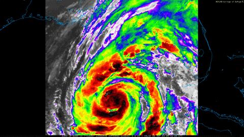
And there's the eye just starting to peek out from underneath on IR, should be go time now or within the next couple of hours

1 likes

Re: ATL: HELENE - Hurricane - Discussion
Second recon pass, 967.7 mbar extrapolated, down 1.4 mbar from the last pass.
5 likes
Re: ATL: HELENE - Hurricane - Discussion
Helene has about 19 hours left over water before landfall. If the current intensification rate between the last two passes holds (0.8 mb/hr), we're looking at a landfall intensity of about 952 mbar. I'd put that as the theoretically most conservative estimate for landfall intensity. On IR it looks like she's clearing an eye and improving rapidly as we speak. As such a higher intensification rate seems likely with landfall pressure in the 940s. Here is Helene's landfall pressure depending on the average intensification rate from now on.
0 mb/hr = 968 mb
0.5 mb/hr = 958 mb
0.8 mb/hr (current rate) = 952 mb
1.0 mb/hr = 949 mb
1.5 mb/hr = 939 mb
1.75 mb/hr (rapid deepening) = 935 mb
2.0 mb/hr = 930 mb
4.0 mb/hr (Wilma-level deepening) = 892 mb
0 mb/hr = 968 mb
0.5 mb/hr = 958 mb
0.8 mb/hr (current rate) = 952 mb
1.0 mb/hr = 949 mb
1.5 mb/hr = 939 mb
1.75 mb/hr (rapid deepening) = 935 mb
2.0 mb/hr = 930 mb
4.0 mb/hr (Wilma-level deepening) = 892 mb
5 likes

Re: ATL: HELENE - Hurricane - Discussion
RI usually correlates with a near term EWRC.
Hopefully that happens on approach to landfall.
Watch the eyedrops from Recon.
When the eye starts to dry out then an EWRC is hours away.
Hopefully that happens on approach to landfall.
Watch the eyedrops from Recon.
When the eye starts to dry out then an EWRC is hours away.
0 likes
Re: ATL: HELENE - Hurricane - Discussion
Helene seemingly cannot get going into that classic looking major like appearnce. Hurricanes are so intriguing and fascinating, along with so difficult to forecast their structure and intensity even with the best tools available. Still going to be interesting (hopefully NOT) to see if Helene does reach high end major status before landfall. High end CAT2 may be in the cards or low end CAT3. Considering a high end CAT3 low end CAT4, the CAT2 low end CAT3 would be almost like a gift considering the damage factors and potential loss of life. Stay safe folks.
0 likes
-
Keldeo1997
- Category 2

- Posts: 688
- Joined: Fri Oct 11, 2019 11:35 pm
Re: ATL: HELENE - Hurricane - Discussion

It's showtime boys and girls. The dancing VHTs have appeared. Laura had this same structure before she exploded.
2 likes
Re: ATL: HELENE - Hurricane - Discussion
Eye drop of 967 mb with 11 kt winds supports 966 mbar. About 3 - 4 mbar lower than the previous eye drop (970 mb with 4 kt winds).

0 likes
-
eastcoastFL

- Category 5
- Posts: 3996
- Age: 44
- Joined: Thu Apr 12, 2007 12:29 pm
- Location: Palm City, FL
Re: ATL: HELENE - Hurricane - Discussion
Looks like the winds are finally catching up with last nights pressure drops. I’m curious to see if the rain rates also go up. After being cloudy all day yesterday with storms, the sky is clear on this side of the state for now. Looks like a lot of storms are being thrown into NW Florida now.
1 likes
Personal Forecast Disclaimer:
The posts in this forum are NOT official forecast and should not be used as such. They are just the opinion of the poster and may or may not be backed by sound meteorological data. They are NOT endorsed by any professional institution or storm2k.org. For official information, please refer to the NHC and NWS products.
The posts in this forum are NOT official forecast and should not be used as such. They are just the opinion of the poster and may or may not be backed by sound meteorological data. They are NOT endorsed by any professional institution or storm2k.org. For official information, please refer to the NHC and NWS products.
-
Chris_in_Tampa
- Category 5
- Posts: 5101
- Age: 42
- Joined: Thu Jun 21, 2007 11:06 pm
- Location: Tampa, Florida, USA
- Contact:
Re: ATL: HELENE - Hurricane - Discussion
Model forecast for NOAA's tides in Tampa Bay:
https://tidesandcurrents.noaa.gov/ofs/o ... l_forecast
It's hour by hour. Good guide for the timing. It's based on the MLLW datum.
Every datum is different.
For Old Port Tampa the datum is:
https://tidesandcurrents.noaa.gov/datum ... id=8726607
The values for MHHW, for what the NHC uses, I think you would subtract 2.48 feet for that particular station.
For Clearwater Beach, subtract 2.74 to get MHHW for what the NHC uses:
https://tidesandcurrents.noaa.gov/datum ... id=8726724
I have never used it before. At 3:30am EDT I downloaded the images and at 4am I happened to look again and they were higher.
1 likes
Who is online
Users browsing this forum: No registered users and 31 guests