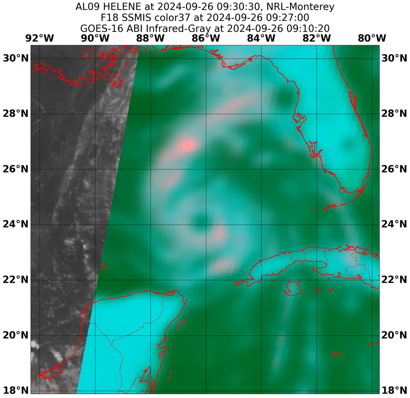
ATL: HELENE - Post-Tropical - Discussion

Moderator: S2k Moderators

Message
Author
User avatar
johngaltfla
Category 5
Category 5
Posts: 2069
Joined: Sun Jul 10, 2005 9:17 pm
Location: Sarasota County, FL
Contact:

Re: ATL: HELENE - Hurricane - Discussion

#2381 Postby johngaltfla » Thu Sep 26, 2024 7:34 am

gatorcane wrote:
johngaltfla wrote:
NDG wrote:Based on my calculation from the recon fixes on Helene during between 1:48 AM & 6:38 AM, Helene's average heading has been at 29 degrees at 12.6 mph.


If that confirms for the next 4 hours, then the original ICON solution from a few days ago with Cedar Key area would be correct.


The ECMWF and GFS have showed this more NE movement before turning it more NNE later today. The NHC track doesn’t show that for some reason.


Maybe the 11 a.m. update will revise it. They still have it at 15 degrees, but who knows. Recon will keep this group ahead of the game, that's for certain.
1 likes   

User avatar
GCANE
S2K Supporter
S2K Supporter
Posts: 11500
Joined: Mon Oct 22, 2007 8:03 am

Re: ATL: HELENE - Hurricane - Discussion

#2382 Postby GCANE » Thu Sep 26, 2024 7:34 am

Looks like she is strong enough now to push back that trof
0 likes   

User avatar
aspen
Category 5
Category 5
Posts: 8818
Joined: Sat Oct 12, 2019 7:10 pm
Location: Connecticut, USA

Re: ATL: HELENE - Hurricane - Discussion

#2383 Postby aspen » Thu Sep 26, 2024 7:35 am

I’m still floored by the massive extent of Helene’s TS force winds. Consequently, the NHC’s peak surge estimates around the landfall point keep going up. Even if Helene’s struggles yesterday and its large core result in it underperforming intensity-wise (like “only” a 100-105 kt Cat 3 at landfall instead of the 4 everyone was expecting), it’s still going to be extremely impactful.

Also thanks to its Fujiwhara interaction with the ULL over the Midwest and it sticking around for a while, I don’t think I’m gonna have another chance to see comet Tsuchinshan-Atlas before it gets too low in the morning sky. Rats.
1 likes   
Irene '11 Sandy '12 Hermine '16 5/15/2018 Derecho Fay '20 Isaias '20 Elsa '21 Henri '21 Ida '21

I am only a meteorology enthusiast who knows a decent amount about tropical cyclones. Look to the professional mets, the NHC, or your local weather office for the best information.

User avatar
storm_in_a_teacup
Category 1
Category 1
Posts: 421
Joined: Wed Aug 16, 2017 5:01 pm
Location: Huntsville, Alabama (originally from Houston)
Contact:

Re: ATL: HELENE - Hurricane - Discussion

#2384 Postby storm_in_a_teacup » Thu Sep 26, 2024 7:35 am

GCANE wrote:She is pretty much draining the EPAC swamp

https://tropic.ssec.wisc.edu/real-time/ ... anim=html5


She’s very hungry, I see :eek:
0 likes   
I know I can't straddle the atmosphere...just a tiny storm in your teacup, girl.

User avatar
GCANE
S2K Supporter
S2K Supporter
Posts: 11500
Joined: Mon Oct 22, 2007 8:03 am

Re: ATL: HELENE - Hurricane - Discussion

#2385 Postby GCANE » Thu Sep 26, 2024 7:35 am

0 likes   

xironman
S2K Supporter
S2K Supporter
Posts: 2522
Joined: Sun Jun 10, 2007 4:53 pm
Location: NoVA

Re: ATL: HELENE - Hurricane - Discussion

#2386 Postby xironman » Thu Sep 26, 2024 7:36 am

NOAA's center looks NNE, of course the vortex can bounce around in a dynamic storm
1 likes   

Michele B
S2K Supporter
S2K Supporter
Posts: 1114
Joined: Thu Aug 25, 2016 8:08 am
Location: SWFL

Re: ATL: HELENE - Hurricane - Discussion

#2387 Postby Michele B » Thu Sep 26, 2024 7:38 am

Bamagirl2408 wrote:
Michele B wrote:
Bamagirl2408 wrote:Actually, it was Mike Seidel who was videoed struggling with the winds while the two boys walking normally in the background with no troubles standing up :D


Well Dang!!!! in my mind it was Cantore! Still liking the new channel discovery for coverage.


I thought it was Cantore, too.

So if it was Seidel, was he canned? Is that why he's on Fox Weather now?


I thought he was cut sometime around Covid in a layoff. No idea!


\Bamagirl,

Is that YT channel (for FoxWeather) a pay channel or just subscriber?
1 likes   
Cleo - 1964, Betsy - 1965, David - 1979, Andrew - 1992, Charlie (Francis, Ivan, Jeanne) - 2004, Irma - 2017, Ian - 2022

caneman
Category 5
Category 5
Posts: 1447
Joined: Fri Sep 05, 2014 5:44 am
Location: Clearwater Beach, Fl

Re: ATL: HELENE - Hurricane - Discussion

#2388 Postby caneman » Thu Sep 26, 2024 7:38 am

HurricaneBelle wrote:This storm may yet go east of forecast with all the S2Kers pushing it in that direction.


It isn't pushing anything. On the right side of cone would mean far more effects for other areas to include hurricane gusts and worse surge. Not really that funny for those living in flood zone a. Including family living in low lying Oldsmar and many other areas. For the record. I've been saying Cedar Key to perry so I wouldn't call that cheerleading.
Last edited by caneman on Thu Sep 26, 2024 7:49 am, edited 2 times in total.
4 likes   

User avatar
NDG
S2K Supporter
S2K Supporter
Posts: 15446
Joined: Sun Jul 09, 2006 10:14 pm
Location: Orlando, FL

Re: ATL: HELENE - Hurricane - Discussion

#2389 Postby NDG » Thu Sep 26, 2024 7:40 am

xironman wrote:NOAA's center looks NNE, of course the vortex can bounce around in a dynamic storm


That's why is good to calculate the heading in between the fixes over a number of hours vs just 1.5 hours.

Which by the way, entering the last NOAA fix compared to the one from the AF recon at 1:30 AM still gives me a 29 deg average heading.
Last edited by NDG on Thu Sep 26, 2024 7:41 am, edited 1 time in total.
8 likes   

User avatar
Hypercane_Kyle
Category 5
Category 5
Posts: 3354
Joined: Sat Mar 07, 2015 7:58 pm
Location: Cape Canaveral, FL

Re: ATL: HELENE - Hurricane - Discussion

#2390 Postby Hypercane_Kyle » Thu Sep 26, 2024 7:41 am

Image

IR really popping off, eye is rapidly clearing.
Last edited by Hypercane_Kyle on Thu Sep 26, 2024 7:41 am, edited 1 time in total.
4 likes   
My posts are my own personal opinion, defer to the National Hurricane Center (NHC) and other NOAA products for decision making during hurricane season.

caneman
Category 5
Category 5
Posts: 1447
Joined: Fri Sep 05, 2014 5:44 am
Location: Clearwater Beach, Fl

Re: ATL: HELENE - Hurricane - Discussion

#2391 Postby caneman » Thu Sep 26, 2024 7:41 am

GCANE wrote:Looks like she is strong enough now to push back that trof


Strong enough usually skews right
1 likes   

technikal
Tropical Low
Tropical Low
Posts: 21
Joined: Tue Sep 24, 2024 1:41 pm

Re: ATL: HELENE - Hurricane - Discussion

#2392 Postby technikal » Thu Sep 26, 2024 7:41 am

HurricaneBelle wrote:
technikal wrote:When you go to bed expecting a primed and ready cat 4 in the middle of RI, waking up to its current look is a relief lol. Still fully prepping for a bad storm but it doesn’t have the look of a potential cat 5 right now, with its current structure and time remaining for RI.


Seeing this post followed by one with this image is the height of irony.

https://i.postimg.cc/hj79Mztd/20240926-092700-AL092024-ssmis-F18-color37-62kts-100p00-res1p0-cr100-ar-H91-bg-Infrared-Gray.png


It is ironic. I guess we’ll see. Conditions have looked favorable for RI since it left the Yucatán Peninsula, hasn’t started yet. I’m closely watching for when it begins. People are overly bullish on these forums, it’s natural. It’s a bad, highly destructive storm. But with only ~15 hours till landfall, imo progression to cat 5 would be legendary at this point.
3 likes   

Sciencerocks
Category 5
Category 5
Posts: 9156
Age: 39
Joined: Thu Jul 06, 2017 1:51 am

Re: ATL: HELENE - Hurricane - Discussion

#2393 Postby Sciencerocks » Thu Sep 26, 2024 7:42 am

Reminds me of wilma in the eastern Gulf as it was making landfall over Florida...Possible cat3 but very larger hurricane with probably 40-60 nmi wide eye.
1 likes   

User avatar
WaveBreaking
Category 2
Category 2
Posts: 578
Joined: Sun Jun 30, 2024 11:33 am
Location: US

Re: ATL: HELENE - Hurricane - Discussion

#2394 Postby WaveBreaking » Thu Sep 26, 2024 7:43 am

Half of the eyewall is lighting up with VHTs

Image
3 likes   
I am NOT a professional meteorologist, so take all of my posts with a grain of salt. My opinions are mine and mine alone.

wx98
Category 5
Category 5
Posts: 1383
Joined: Sat Aug 25, 2018 9:24 pm

Re: ATL: HELENE - Hurricane - Discussion

#2395 Postby wx98 » Thu Sep 26, 2024 7:43 am

Michele B wrote:
Bamagirl2408 wrote:
Frank P wrote:

Actually, it was Mike Seidel who was videoed struggling with the winds while the two boys walking normally in the background with no troubles standing up :D


Well Dang!!!! in my mind it was Cantore! Still liking the new channel discovery for coverage.


I thought it was Cantore, too.

So if it was Seidel, was he canned? Is that why he's on Fox Weather now?

Supposedly he was “part time” and they let a bunch of part timers go.
0 likes   

xironman
S2K Supporter
S2K Supporter
Posts: 2522
Joined: Sun Jun 10, 2007 4:53 pm
Location: NoVA

Re: ATL: HELENE - Hurricane - Discussion

#2396 Postby xironman » Thu Sep 26, 2024 7:44 am

NDG wrote:
xironman wrote:NOAA's center looks NNE, of course the vortex can bounce around in a dynamic storm


That's why is good to calculate the heading in between the fixes over a number of hours vs just 1.5 hours.

Which by the way, entering the last NOAA fix compared to the one from the AF recon at 1:30 AM still gives me a 29 deg average heading.


That would take all the fun out of wobble watching
2 likes   

LandoWill
Tropical Storm
Tropical Storm
Posts: 154
Joined: Sun Sep 25, 2022 10:25 pm

Re: ATL: HELENE - Hurricane - Discussion

#2397 Postby LandoWill » Thu Sep 26, 2024 7:48 am

Image ninja shift by NHC.
0 likes   

User avatar
ronjon
Category 5
Category 5
Posts: 4822
Joined: Fri Aug 19, 2005 5:17 pm
Location: Hernando Beach, FL

Re: ATL: HELENE - Hurricane - Discussion

#2398 Postby ronjon » Thu Sep 26, 2024 7:49 am

caneman wrote:
HurricaneBelle wrote:This storm may yet go east of forecast with all the S2Kers pushing it in that direction.


It isn't pushing anything. One the right side of cone would mean far more effects for other areas to include hurricane gusts and worse surge. Not really that funny for those living in flood zone a. Including family living in low lying Oldsmar and many other areas. For the record. I've been saying Cedar Key to perry so I wouldn't call that cheerleading.


Nobody is -removed- here. When you have our best models such as GFS, Euro, Euro AI, ICON, and now GFS ensembles pointing toward a closer approach to the Florida west coast you start paying attention - particularly us posters on the west side of the state.
6 likes   

tolakram
Admin
Admin
Posts: 20012
Age: 62
Joined: Sun Aug 27, 2006 8:23 pm
Location: Florence, KY (name is Mark)

Re: ATL: HELENE - Hurricane - Discussion

#2399 Postby tolakram » Thu Sep 26, 2024 7:49 am

technikal wrote:
HurricaneBelle wrote:
technikal wrote:When you go to bed expecting a primed and ready cat 4 in the middle of RI, waking up to its current look is a relief lol. Still fully prepping for a bad storm but it doesn’t have the look of a potential cat 5 right now, with its current structure and time remaining for RI.


Seeing this post followed by one with this image is the height of irony.

https://i.postimg.cc/hj79Mztd/20240926-092700-AL092024-ssmis-F18-color37-62kts-100p00-res1p0-cr100-ar-H91-bg-Infrared-Gray.png


It is ironic. I guess we’ll see. Conditions have looked favorable for RI since it left the Yucatán Peninsula, hasn’t started yet. I’m closely watching for when it begins. People are overly bullish on these forums, it’s natural. It’s a bad, highly destructive storm. But with only ~15 hours till landfall, imo progression to cat 5 would be legendary at this point.


Who is predicting cat 5? Ever? High cat 3 or low cat 4 is all that was ever reasonable.

IMO the bigger the storm is the lower the category will be and the higher the damage. This is why I think Saffir Simpson is useless for large storms, except to say that is this beast actually reaches cat 4 the damage will be extraordinary just from the surge alone.
5 likes   
M a r k
- - - - -
Join us in chat: Storm2K Chatroom Invite. Android and IOS apps also available.

The posts in this forum are NOT official forecasts and should not be used as such. Posts are NOT endorsed by any professional institution or STORM2K.org. For official information and forecasts, please refer to NHC and NWS products.

User avatar
Steve
S2K Supporter
S2K Supporter
Posts: 9621
Joined: Sat Apr 05, 2003 11:41 pm
Location: Not a state-caster

Re: ATL: HELENE - Hurricane - Discussion

#2400 Postby Steve » Thu Sep 26, 2024 7:50 am

WaveBreaking wrote:Half of the eyewall is lighting up with VHTs

https://i.imgur.com/H8q7dnJ.gif


It’s not done that’s for sure.
3 likes   


Return to “2024”

Who is online

Users browsing this forum: No registered users and 3 guests