
946.6 extrap so far. My prediction range was pretty good.
Excellent improvement on the west side.
ATL: HELENE - Post-Tropical - Discussion
Moderator: S2k Moderators
Re: ATL: HELENE - Hurricane - Discussion
2 likes
Irene '11 Sandy '12 Hermine '16 5/15/2018 Derecho Fay '20 Isaias '20 Elsa '21 Henri '21 Ida '21
I am only a meteorology enthusiast who knows a decent amount about tropical cyclones. Look to the professional mets, the NHC, or your local weather office for the best information.
I am only a meteorology enthusiast who knows a decent amount about tropical cyclones. Look to the professional mets, the NHC, or your local weather office for the best information.
-
johngaltfla

- Category 5

- Posts: 2073
- Joined: Sun Jul 10, 2005 9:17 pm
- Location: Sarasota County, FL
- Contact:
Re: ATL: HELENE - Hurricane - Discussion
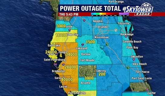
ConvergenceZone wrote:johngaltfla wrote:caneman wrote:43,000 without power in Tampa Bay
And climbing regionally.
https://johngaltfla.com/wp-content/uploads/2024/09/Screen-Shot-09-26-24-at-05.46-PM.jpg
does anyone know of a site where you can get a map like you show that shows updated power outages across the affected states?
https://www.fox13news.com/news/hurrican ... a-bay-area
0 likes
-
ConvergenceZone
.gif)
- Category 5
- Posts: 5241
- Joined: Fri Jul 29, 2005 1:40 am
- Location: Northern California
Re: ATL: HELENE - Hurricane - Discussion
Hurrilurker wrote:I guess the "good" news is the coastal areas near where the center is projected to make landfall appear to mostly be a giant network of nature reserves and state parks with very few human occupants. Although that probably also means it will be more difficult to get help into those areas.
but the bad news is that very high winds will move inland and projected to go through several towns well past Tallahassee. This damage will be enhanced if Helene does indeed strengthen up until landfall.
3 likes
-
johngaltfla
- Category 5
- Posts: 2073
- Joined: Sun Jul 10, 2005 9:17 pm
- Location: Sarasota County, FL
- Contact:
Re: ATL: HELENE - Hurricane - Discussion
aspen wrote:946.6 extrap so far. My prediction range was pretty good.
Excellent improvement on the west side.
No bueno.
I hope that doesn't swing around before landfall.
1 likes

Re: ATL: HELENE - Hurricane - Discussion
caneman wrote:Nimbus wrote:caneman wrote:43,000 without power in Tampa Bay
NHC shifted track to the crack..
Might save Tally?
https://www.sfwmd.gov/weather-radar/cur ... conditions
Probably but it's looked like Perry from the beginning.
I'm thinking between Perry and Steinhatchee. Definitely Taylor County. Euro, GFS, UK, ICON all zeroed in on a 20 mile strip of coast.
1 likes
-
StormPyrate
- Category 1

- Posts: 286
- Joined: Sun May 27, 2018 8:41 pm
- Location: Clearwater, FL
Re: ATL: HELENE - Hurricane - Discussion
ConvergenceZone wrote:johngaltfla wrote:caneman wrote:43,000 without power in Tampa Bay
And climbing regionally.
https://johngaltfla.com/wp-content/uploads/2024/09/Screen-Shot-09-26-24-at-05.46-PM.jpg
does anyone know of a site where you can get a map like you show that shows updated power outages across the affected states?
https://outagemap.duke-energy.com/#/current-outages/fl
0 likes
St Petersburg Florida
-
ConvergenceZone
- Category 5
- Posts: 5241
- Joined: Fri Jul 29, 2005 1:40 am
- Location: Northern California
Re: ATL: HELENE - Hurricane - Discussion
johngaltfla wrote:ConvergenceZone wrote:johngaltfla wrote:
And climbing regionally.
https://johngaltfla.com/wp-content/uploads/2024/09/Screen-Shot-09-26-24-at-05.46-PM.jpg
does anyone know of a site where you can get a map like you show that shows updated power outages across the affected states?
https://www.fox13news.com/news/hurrican ... a-bay-area
Thanks, although I wish there was a map that would actually show the power outages since it would be easier to read. I'll keep googling it and see what I can find.
0 likes
Re: ATL: HELENE - Hurricane - Discussion
johngaltfla wrote:ConvergenceZone wrote:johngaltfla wrote:
And climbing regionally.
https://johngaltfla.com/wp-content/uploads/2024/09/Screen-Shot-09-26-24-at-05.46-PM.jpg
does anyone know of a site where you can get a map like you show that shows updated power outages across the affected states?
https://www.fox13news.com/news/hurrican ... a-bay-area
Also Duke energy just Google and then maybe Tampa electric and combine numbers
1 likes
-
ConvergenceZone
- Category 5
- Posts: 5241
- Joined: Fri Jul 29, 2005 1:40 am
- Location: Northern California
Re: ATL: HELENE - Hurricane - Discussion
StormPyrate wrote:ConvergenceZone wrote:johngaltfla wrote:
And climbing regionally.
https://johngaltfla.com/wp-content/uploads/2024/09/Screen-Shot-09-26-24-at-05.46-PM.jpg
does anyone know of a site where you can get a map like you show that shows updated power outages across the affected states?
https://outagemap.duke-energy.com/#/current-outages/fl
this is more what I was looking for. thanks.
0 likes
-
WaveBreaking

- Category 2

- Posts: 728
- Joined: Sun Jun 30, 2024 11:33 am
- Location: US
Re: ATL: HELENE - Hurricane - Discussion
Full W Ring on Dvorak

11 likes
I am NOT a professional meteorologist, so take all of my posts with a grain of salt. My opinions are mine and mine alone.
Re: ATL: HELENE - Hurricane - Discussion
ronjon wrote:caneman wrote:Nimbus wrote:
NHC shifted track to the crack..
Might save Tally?
https://www.sfwmd.gov/weather-radar/cur ... conditions
Probably but it's looked like Perry from the beginning.
I'm thinking between Perry and Steinhatchee. Definitely Taylor County. Euro, GFS, UK, ICON all zeroed in on a 20 mile strip of coast.
100% you, I and NDG were on it and maybe a few others. I've lived here since 1976. You kinda learn how these things behave minus the meteorology degree. Credit to Bay News 9 and Spectrum News they've been all over Perry area or Taylor county. Klystron is the real deal!
Last edited by caneman on Thu Sep 26, 2024 5:06 pm, edited 3 times in total.
2 likes
-
FLLurker32
- Tropical Storm

- Posts: 245
- Joined: Mon Aug 29, 2016 10:31 am
Re: ATL: HELENE - Hurricane - Discussion
Taylor county has asked that anyone who stays in an evacuation zone to write their name, birthday and important identifying information on their arm in permanent marker.
No matter how many times I’ve seen counties request this, it’s always a sick gut feeling to read.
No matter how many times I’ve seen counties request this, it’s always a sick gut feeling to read.
9 likes
Heather
-
PavelGaborik10
- Category 1
- Posts: 472
- Joined: Tue Sep 04, 2018 3:23 pm
Re: ATL: HELENE - Hurricane - Discussion
Uh, did NHC just lower the intensity of a rapidly intensifying major hurricane mere hours from landfall?
1 likes

Re: ATL: HELENE - Hurricane - Discussion
946.2 extrap, 136 FL winds in the eastern eyewall 
215230 2754N 08422W 7527 02045 9467 +227 +145 204039 042 /// /// 03
215300 2754N 08419W 7519 02057 9462 +239 +130 205044 045 /// /// 03
215330 2754N 08417W 7517 02061 9466 +237 +139 204050 053 /// /// 03
215400 2753N 08414W 7523 02063 9478 +227 +157 201063 071 /// /// 03
215430 2753N 08412W 7522 02078 9510 +199 +171 199077 082 /// /// 03
215500 2753N 08409W 7521 02097 9537 +186 +185 198088 089 /// /// 05
215530 2753N 08407W 7512 02125 9556 +184 +180 200099 107 /// /// 03
215600 2753N 08404W 7512 02138 9582 +173 +187 198124 128 /// /// 05
215630 2753N 08402W 7529 02135 9603 +171 +182 195130 134 /// /// 05
215700 2753N 08400W 7497 02186 9627 +161 +188 188134 136 /// /// 05
215730 2753N 08358W 7523 02178 9648 +159 +183 186134 136 /// /// 05
215800 2753N 08356W 7522 02206 9676 +163 +182 185126 130 /// /// 05
215830 2753N 08354W 7524 02225 9705 +156 +175 184118 124 /// /// 05
215900 2753N 08351W 7513 02254 9717 +162 +175 184116 117 /// /// 05
215930 2753N 08349W 7523 02258 9726 +169 +177 185110 115 /// /// 05
220000 2753N 08347W 7516 02273 9741 +164 +177 187108 108 /// /// 05
220030 2753N 08345W 7518 02286 9754 +164 +174 184104 108 /// /// 05
220100 2753N 08343W 7516 02295 9763 +165 +168 183099 102 /// /// 05
220130 2753N 08341W 7519 02299 9775 +162 +168 184096 097 /// /// 05
220200 2753N 08339W 7520 02305 9779 +165 +174 184095 096 /// /// 05
Last edited by Travorum on Thu Sep 26, 2024 5:04 pm, edited 1 time in total.
7 likes
-
KirbyDude25

- Tropical Storm
- Posts: 162
- Age: 21
- Joined: Mon Sep 20, 2021 8:03 am
- Location: Westfield, New Jersey
Re: ATL: HELENE - Hurricane - Discussion
PavelGaborik10 wrote:Uh, did NHC just lower the intensity of a rapidly intensifying major hurricane mere hours from landfall?
To be fair, they have more data than us, so I'm sure there's a good reason. That, or they just made a typo
2 likes
New Jersey, Rutgers '27
Irene 2011 | Sandy 2012 | Fay 2020 | Isaias 2020 | Ida 2021
Irene 2011 | Sandy 2012 | Fay 2020 | Isaias 2020 | Ida 2021


Re: ATL: HELENE - Hurricane - Discussion
Cat 4!
RNT15 KWBC 262202
NOAA2 1709A HELENE HDOB 13 20240926
215230 2754N 08422W 7527 02045 9467 +227 +145 204039 042 /// /// 03
215300 2754N 08419W 7519 02057 9462 +239 +130 205044 045 /// /// 03
215330 2754N 08417W 7517 02061 9466 +237 +139 204050 053 /// /// 03
215400 2753N 08414W 7523 02063 9478 +227 +157 201063 071 /// /// 03
215430 2753N 08412W 7522 02078 9510 +199 +171 199077 082 /// /// 03
215500 2753N 08409W 7521 02097 9537 +186 +185 198088 089 /// /// 05
215530 2753N 08407W 7512 02125 9556 +184 +180 200099 107 /// /// 03
215600 2753N 08404W 7512 02138 9582 +173 +187 198124 128 /// /// 05
215630 2753N 08402W 7529 02135 9603 +171 +182 195130 134 /// /// 05
215700 2753N 08400W 7497 02186 9627 +161 +188 188134 136 /// /// 05
215730 2753N 08358W 7523 02178 9648 +159 +183 186134 136 /// /// 05
215800 2753N 08356W 7522 02206 9676 +163 +182 185126 130 /// /// 05
215830 2753N 08354W 7524 02225 9705 +156 +175 184118 124 /// /// 05
215900 2753N 08351W 7513 02254 9717 +162 +175 184116 117 /// /// 05
215930 2753N 08349W 7523 02258 9726 +169 +177 185110 115 /// /// 05
220000 2753N 08347W 7516 02273 9741 +164 +177 187108 108 /// /// 05
220030 2753N 08345W 7518 02286 9754 +164 +174 184104 108 /// /// 05
220100 2753N 08343W 7516 02295 9763 +165 +168 183099 102 /// /// 05
220130 2753N 08341W 7519 02299 9775 +162 +168 184096 097 /// /// 05
220200 2753N 08339W 7520 02305 9779 +165 +174 184095 096 ///
2 likes

Re: ATL: HELENE - Hurricane - Discussion
As one frame of reference for inland penetration of hurricane winds: Hurricane Hugo, 1989 produced measured wind of 99 mph at Charlotte, NC airport 205 miles from the coast
4 likes
List of 79 tropical cyclones intercepted by Richard Horodner:
http://www.canebeard.com/page/page/572246.htm
former storm2k screenname Beoumont 2009+
http://www.canebeard.com/page/page/572246.htm
former storm2k screenname Beoumont 2009+

Re: ATL: HELENE - Hurricane - Discussion
PavelGaborik10 wrote:Uh, did NHC just lower the intensity of a rapidly intensifying major hurricane mere hours from landfall?
It looks that way but it won't be for long after that most recent recon pass
3 likes
-
PavelGaborik10
- Category 1
- Posts: 472
- Joined: Tue Sep 04, 2018 3:23 pm
Re: ATL: HELENE - Hurricane - Discussion
KirbyDude25 wrote:PavelGaborik10 wrote:Uh, did NHC just lower the intensity of a rapidly intensifying major hurricane mere hours from landfall?
To be fair, they have more data than us, so I'm sure there's a good reason. That, or they just made a typo
Have they even sampled the eastern side yet?
This has to be a typo
089
WTNT64 KNHC 262200
TCUAT4
Hurricane Helene Tropical Cyclone Update
NWS National Hurricane Center Miami FL AL092024
600 PM EDT Thu Sep 26 2024
...HELENE CONTINUES HEADING FOR THE FLORIDA BIG BEND...
...TROPICAL STORM CONDITIONS SPREADING NORTHWARD ALONG THE WEST
COAST OF FLORIDA...
A slightly elevated Weatherflow station at the Skyway Fishing Pier
near the entrance to Tampa Bay recently measured a sustained wind
of 50 mph (80 km/h) and a gust to 69 mph (111 km/h).
SUMMARY OF 600 PM EDT...2200 UTC...INFORMATION
----------------------------------------------
LOCATION...28.0N 84.5W
ABOUT 115 MI...185 KM W OF TAMPA FLORIDA
ABOUT 210 MI...335 KM SW OF TALLAHASSEE FLORIDA
MAXIMUM SUSTAINED WINDS...120 MPH...195 KM/H
PRESENT MOVEMENT...NNE OR 25 DEGREES AT 21 MPH...33 KM/H
MINIMUM CENTRAL PRESSURE...950 MB...28.05 INCHES
$$
Forecaster Bucci
3 likes
Who is online
Users browsing this forum: No registered users and 49 guests