
TampaCE wrote:We lost power here in St Pete about 30 minutes ago. Can someone tell me roughly how much longer Helene has over water until she makes landfall?
ATL: HELENE - Post-Tropical - Discussion
Moderator: S2k Moderators
Re: ATL: HELENE - Hurricane - Discussion
Knabb literally just said he thought 2-2.5 hours…
1 likes
-
TallyTracker
- Category 2

- Posts: 787
- Joined: Thu Oct 11, 2018 2:46 pm
Re: ATL: HELENE - Hurricane - Discussion
I’d say landfall is looking like Econfina River State Park. There is a road down to the coast there with a few houses and an RV park. The eye should pass west of Perry.
1 likes
Fran '96, Georges '98, Gordon '00, Gabrielle '01, Charley '04, Frances '04, Jeanne '04, Barry '07, Fay '08, Debby '12, Matthew '16, Emily '17, Irma '17, Michael ‘18, Elsa ‘21, Fred ‘21, Mindy ‘21, Nicole ‘22, Idalia ‘23, Debby ‘24, Helene ‘24

Re: ATL: HELENE - Hurricane - Discussion
fllawyer wrote:Knabb literally just said he thought 2-2.5 hours…TampaCE wrote:We lost power here in St Pete about 30 minutes ago. Can someone tell me roughly how much longer Helene has over water until she makes landfall?
Thanks. Just trying to do some mental math of when the winds might lie down a bit.
0 likes

Re: ATL: HELENE - Hurricane - Discussion
redingtonbeach wrote:caneman wrote:Zarniwoop wrote:Anyone have some good links to cameras showing the effects of the storm rolling in? Preferably where it’s worst.
Spectrum News and Bay News 9 on tv just showed Gulf blvd completely underwater. Check out their website and fb page. Shocking!
Not shocking at all. Hurricane Camille hit Texas I think yet caused 4' of flooding on the Gulf Blvd up and down the beaches.
Ryan Hall
https://www.youtube.com/live/XTnlp7qrTY ... w-LaMjxQG1
Reed Timmer
https://www.youtube.com/live/vo0NhYV00p ... hB270bSO16
Brandon Copic
https://www.youtube.com/live/4ktY30sV6R ... yVaYk6fvVG
4 likes
-
wzrgirl1

- S2K Supporter

- Posts: 1360
- Joined: Sat Sep 04, 2004 6:44 am
- Location: Pembroke Pines, Florida
Re: ATL: HELENE - Hurricane - Discussion
chaser1 wrote:wzrgirl1 wrote:Can somebody please post the fsu experimental global forecast models....it was one page with 5 or 6 models. I had it but I seen to have lost it.
I thought that was completely unavailable to the public and for "NHC eyes only"??
I have had a few times over the years but I seem to have lost it. I thought I bookmarked it. Apparently not.
1 likes
-
Blown Away

- S2K Supporter
- Posts: 10253
- Joined: Wed May 26, 2004 6:17 am
Re: ATL: HELENE - Hurricane - Discussion
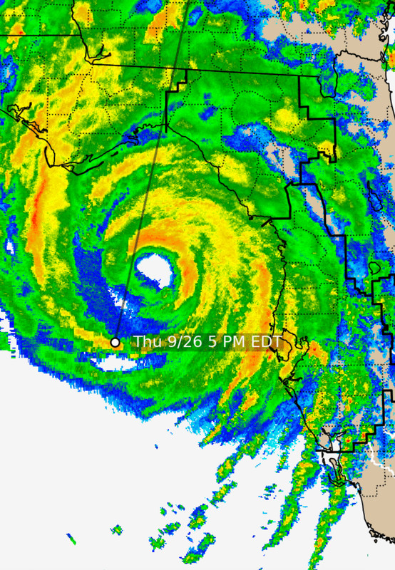
NHC is amazing… But climatology leans towards Cedar Key…
1 likes
Hurricane Eye Experience: David 79, Irene 99, Frances 04, Jeanne 04, Wilma 05… Hurricane Brush Experience: Andrew 92, Erin 95, Floyd 99, Matthew 16, Irma 17, Ian 22, Nicole 22…
Re: ATL: HELENE - Hurricane - Discussion
TallyTracker wrote:I’d say landfall is looking like Econfina River State Park. There is a road down to the coast there with a few houses and an RV park. The eye should pass west of Perry.
You got out right?
0 likes

Re: ATL: HELENE - Hurricane - Discussion
356
URNT12 KNHC 270015
VORTEX DATA MESSAGE AL092024
A. 26/23:35:50Z
B. 28.59 deg N 084.33 deg W
C. 700 mb 2644 m
D. 943 mb
E. 125 deg 10 kt
F. CLOSED
G. C30
H. 79 kt
I. 274 deg 9 nm 23:33:30Z
J. 011 deg 67 kt
K. 275 deg 10 nm 23:33:00Z
L. 108 kt
M. 083 deg 23 nm 23:45:00Z
N. 183 deg 134 kt
O. 085 deg 28 nm 23:46:30Z
P. 13 C / 3063 m
Q. 21 C / 3044 m
R. 8 C / NA
S. 12345 / 7
T. 0.02 / 1.5 nm
U. AF306 1809A HELENE OB 02
MAX FL WIND 134 KT 085 / 28 NM 23:46:30Z
;
700mb FL 134
2 likes
-
CrazyC83
- Professional-Met

- Posts: 34316
- Joined: Tue Mar 07, 2006 11:57 pm
- Location: Deep South, for the first time!
Re: ATL: HELENE - Hurricane - Discussion
That data supports 120 kt, or if they think radar velocities are stronger, 125 kt. I'd ignore the SFMR this close to shore due to shoaling issues.
7 likes

Re: ATL: HELENE - Hurricane - Discussion
Air force seems to have some lag in sending data but now has a VDM up. Didn’t capture the data on the HDOBs, but it seems like 943mb extrap with 134kt FL wind:

Last edited by Travorum on Thu Sep 26, 2024 7:37 pm, edited 1 time in total.
2 likes
-
TallyTracker
- Category 2
- Posts: 787
- Joined: Thu Oct 11, 2018 2:46 pm
Re: ATL: HELENE - Hurricane - Discussion
Steve wrote:TallyTracker wrote:I’d say landfall is looking like Econfina River State Park. There is a road down to the coast there with a few houses and an RV park. The eye should pass west of Perry.
You got out right?
Yep! I’m holed up near Mobile, AL. Didn’t want to take any chances. As glad as I am the track is trending east, the NW winds worry me as that is the only direction a tree could easily fall on my house. I’m hoping the winds are weaker once it shifts to that direction.
6 likes
Fran '96, Georges '98, Gordon '00, Gabrielle '01, Charley '04, Frances '04, Jeanne '04, Barry '07, Fay '08, Debby '12, Matthew '16, Emily '17, Irma '17, Michael ‘18, Elsa ‘21, Fred ‘21, Mindy ‘21, Nicole ‘22, Idalia ‘23, Debby ‘24, Helene ‘24
Re: ATL: HELENE - Hurricane - Discussion
Blown Away wrote:[url]https://i.postimg.cc/Bn4F3gxV/IMG-0379.jpg [/url]
NHC is amazing… But climatology leans towards Cedar Key…
The official landfall point is going to be much closer to that path you show than Cedar Key.
1 likes
-
jlauderdal
- S2K Supporter
- Posts: 7240
- Joined: Wed May 19, 2004 5:46 am
- Location: NE Fort Lauderdale
- Contact:
Re: ATL: HELENE - Hurricane - Discussion
Camille and Tip3090 wrote:Steve wrote:redingtonbeach wrote:
Not shocking at all. Hurricane Camille hit Texas I think yet caused 4' of flooding on the Gulf Blvd up and down the beaches.
Camille hit Bay St. Louis MS and exited the VA Coast still classified. Must have been a different one or an earlier Camille?
Only ONE Camille. None other. 1969.
0 likes
-
TampaWxLurker
- Tropical Storm

- Posts: 196
- Joined: Thu Aug 01, 2024 8:20 am
-
HurricaneBelle

- S2K Supporter
- Posts: 1209
- Joined: Sun Aug 27, 2006 6:12 pm
- Location: Clearwater, FL
Re: ATL: HELENE - Hurricane - Discussion
Just had the nastiest of squalls come through here in Clearwater so I went to my front door to look outside, heard what I thought was thunder but instead it was a transformer blowing to my south and the sky lit up like lightning except it was blue/green. Never saw one do that before. Still have power but I'm surrounded on the Duke outage map by them.
3 likes

Re: ATL: HELENE - Hurricane - Discussion
TallyTracker wrote:I’d say landfall is looking like Econfina River State Park. There is a road down to the coast there with a few houses and an RV park. The eye should pass west of Perry.
I am in your neck of the woods. We left Sopchoppy, staying in a hotel on App pkwy and Blairstone. So far so good here, starting to pick up a bit now.
1 likes

Re: ATL: HELENE - Hurricane - Discussion
82 mph wind gust in downtown St Pete, GFS and Euro were more right than wrong with the forecasted wind gusts.
Sep 26, 7:53 pm 83 80 91 95 S 47G82
Sep 26, 7:53 pm 83 80 91 95 S 47G82
3 likes
-
Kingarabian

- S2K Supporter
- Posts: 16378
- Joined: Sat Aug 08, 2009 3:06 am
- Location: Honolulu, Hawaii
Re: ATL: HELENE - Hurricane - Discussion
Still an instantaneous T6.5 since the W ring keeps breaking but so close to a 7.0. Constraints are helping to keep the CI honest though as
Dvorak would be overdoing intensity at the moment as the winds have yet to catch up.
Dvorak would be overdoing intensity at the moment as the winds have yet to catch up.
Last edited by Kingarabian on Thu Sep 26, 2024 7:44 pm, edited 1 time in total.
2 likes
RIP Kobe Bryant
Re: ATL: HELENE - Hurricane - Discussion
Down to 941.8mb extrap on NOAA
NOAA2 1709A HELENE HDOB 28 20240927
002300 2828N 08406W 7512 02203 9616 +224 +130 250103 103 /// /// 03
002330 2830N 08406W 7512 02186 9589 +230 +150 251101 103 /// /// 03
002400 2832N 08406W 7525 02142 9537 +265 +143 258103 108 /// /// 03
002430 2834N 08406W 7526 02112 9513 +255 +149 259104 111 /// /// 03
002500 2836N 08406W 7525 02086 9493 +243 +158 261082 096 /// /// 03
002530 2838N 08406W 7519 02074 9484 +229 +158 258074 078 /// /// 03
002600 2840N 08406W 7516 02063 9467 +233 +163 253061 070 /// /// 03
002630 2843N 08406W 7517 02053 9449 +245 +157 240047 056 /// /// 03
002700 2845N 08406W 7518 02041 9441 +244 +150 229040 042 /// /// 03
002730 2847N 08406W 7515 02037 9427 +253 +141 222038 039 /// /// 03
002800 2850N 08406W 7518 02031 9418 +262 +127 214041 042 /// /// 03
002830 2852N 08406W 7524 02019 9423 +248 +129 203037 039 /// /// 03
002900 2854N 08404W 7516 02026 9424 +242 +137 199036 038 /// /// 03
002930 2854N 08402W 7519 02024 9436 +224 +148 192037 039 /// /// 03
003000 2852N 08401W 7516 02032 9444 +219 +145 198044 045 /// /// 03
003030 2852N 08403W 7518 02028 9432 +237 +133 199044 045 /// /// 03
003100 2853N 08404W 7519 02023 9420 +247 +128 198042 044 /// /// 03
003130 2856N 08403W 7516 02022 9422 +239 +140 193039 042 /// /// 03
003200 2857N 08402W 7522 02017 9420 +241 +149 184037 038 /// /// 03
003230 2859N 08400W 7519 02021 9423 +241 +140 178044 046 /// /// 03
2 likes
Re: ATL: HELENE - Hurricane - Discussion
HurricaneBelle wrote: it was a transformer blowing to my south and the sky lit up like lightning except it was blue/green. Never saw one do that before.
That unique effect never gets old, except it also instantly sucks because downstream lights are going to be out for quite a bit.
4 likes
Baton Rouge area cyclone dilettante, PSWAGGER* tropical weather & hydrology model developer
(* Pseudo-Scientific Wild-A** Guesses Generally Expressed Ridiculously)
The GFDL would've had all this figured out by now.
(* Pseudo-Scientific Wild-A** Guesses Generally Expressed Ridiculously)
The GFDL would've had all this figured out by now.
Who is online
Users browsing this forum: No registered users and 64 guests