Possible development in the Eastern Atlantic (Is Invest 90L)

This is the general tropical discussion area. Anyone can take their shot at predicting a storms path.

Moderator: S2k Moderators

Forum rules

The posts in this forum are NOT official forecasts and should not be used as such. They are just the opinion of the poster and may or may not be backed by sound meteorological data. They are NOT endorsed by any professional institution or STORM2K. For official information, please refer to products from the National Hurricane Center and National Weather Service.

Help Support Storm2K
Message
Author
User avatar
cycloneye
Admin
Admin
Posts: 143862
Age: 68
Joined: Thu Oct 10, 2002 10:54 am
Location: San Juan, Puerto Rico

Possible development in the Eastern Atlantic (Is Invest 90L)

#1 Postby cycloneye » Fri Sep 27, 2024 6:52 am

8 AM:

Eastern Tropical Atlantic:
An area of low pressure could form over the eastern tropical
Atlantic by the early to middle part of next week. Environmental
conditions are expected to be conducive for slow development
thereafter while the system moves generally northwestward at 10 to
15 mph.
* Formation chance through 48 hours...low...near 0 percent.
* Formation chance through 7 days...low...20 percent.


Image
0 likes   
Visit the Caribbean-Central America Weather Thread where you can find at first post web cams,radars
and observations from Caribbean basin members Click Here

User avatar
Teban54
Category 5
Category 5
Posts: 3168
Joined: Sat May 19, 2018 1:19 pm

Re: Possible development in the Eastern Atlantic

#2 Postby Teban54 » Fri Sep 27, 2024 7:47 am

We've finally got to the stage where storms are popping up like rabbits. :lol:

This is the storm that both global and ensemble models were making a potent west-moving MH a few runs ago. They've trended away from that direction now, partly because it's now expected to recurve much earlier at 40-50W. Right now, GFS, Euro and their ensembles still have a strong hurricane on the recurve. However, this is exactly what they had for Gordon and soon-to-be Joyce.
3 likes   

User avatar
cycloneye
Admin
Admin
Posts: 143862
Age: 68
Joined: Thu Oct 10, 2002 10:54 am
Location: San Juan, Puerto Rico

Re: Possible development in the Eastern Atlantic

#3 Postby cycloneye » Fri Sep 27, 2024 11:55 am

12z GFS develops a monster cane, but it moves it strait to the north and if that happens, it may not produce a good deal of ACE.

Image
4 likes   
Visit the Caribbean-Central America Weather Thread where you can find at first post web cams,radars
and observations from Caribbean basin members Click Here

User avatar
Travorum
Category 1
Category 1
Posts: 406
Joined: Tue Sep 05, 2023 9:36 am
Location: Dunedin, FL

Re: Possible development in the Eastern Atlantic

#4 Postby Travorum » Fri Sep 27, 2024 12:26 pm

cycloneye wrote:12z GFS develops a monster cane, but it moves it strait to the north and if that happens, it may not produce a good deal of ACE.

https://i.imgur.com/veDtWk8.gif


GFS developed monsters out of both Gordon and Joyce at this equivalent lead time, we shall see if this one sticks.
0 likes   

User avatar
cycloneye
Admin
Admin
Posts: 143862
Age: 68
Joined: Thu Oct 10, 2002 10:54 am
Location: San Juan, Puerto Rico

Re: Possible development in the Eastern Atlantic

#5 Postby cycloneye » Fri Sep 27, 2024 12:57 pm

Up to 30%.

Eastern Tropical Atlantic:
An area of low pressure could form over the eastern tropical
Atlantic by the early to middle part of next week. Environmental
conditions are expected to be conducive for slow development
thereafter while the system moves generally northwestward at 10 to
15 mph.
* Formation chance through 48 hours...low...near 0 percent.
* Formation chance through 7 days...low...30 percent.
0 likes   
Visit the Caribbean-Central America Weather Thread where you can find at first post web cams,radars
and observations from Caribbean basin members Click Here

User avatar
Teban54
Category 5
Category 5
Posts: 3168
Joined: Sat May 19, 2018 1:19 pm

Re: Possible development in the Eastern Atlantic

#6 Postby Teban54 » Fri Sep 27, 2024 12:59 pm

Travorum wrote:
cycloneye wrote:12z GFS develops a monster cane, but it moves it strait to the north and if that happens, it may not produce a good deal of ACE.

https://i.imgur.com/veDtWk8.gif


GFS developed monsters out of both Gordon and Joyce at this equivalent lead time, we shall see if this one sticks.

One thing in favor of this system is MJO being much more cooperative. It should probably be around phase 1-2 at that time, which are typically associated with significant activity in the open Atlantic.
1 likes   

User avatar
galaxy401
Category 5
Category 5
Posts: 2410
Age: 29
Joined: Sat Aug 25, 2012 9:04 pm
Location: Casa Grande, Arizona

Re: Possible development in the Eastern Atlantic

#7 Postby galaxy401 » Fri Sep 27, 2024 2:45 pm

Well it is after the 20th...I told you the switch always flips on the 20th.

Just move everything 30 days later. :lol:
3 likes   
Got my eyes on moving right into Hurricane Alley: Florida.

User avatar
Teban54
Category 5
Category 5
Posts: 3168
Joined: Sat May 19, 2018 1:19 pm

Re: Possible development in the Eastern Atlantic

#8 Postby Teban54 » Fri Sep 27, 2024 6:20 pm

GFS continues to make this a hurricane in the 950s even within MDR proper, while Euro also shows 960s on the recurve past 30N or so. What makes them a bit more believable this time is that the wave has already left Africa.
0 likes   

User avatar
cycloneye
Admin
Admin
Posts: 143862
Age: 68
Joined: Thu Oct 10, 2002 10:54 am
Location: San Juan, Puerto Rico

Re: Possible development in the Eastern Atlantic

#9 Postby cycloneye » Fri Sep 27, 2024 6:29 pm

Eastern and Central Tropical Atlantic:
A broad and elongated area of low pressure, associated with a
tropical wave, is producing limited shower activity near and to the
west of the Cabo Verde Islands. Environmental conditions appear
conducive for gradual development of this system, and a tropical
depression could form next week while moving toward the west and
then northwest at about 10 mph across the eastern and central
tropical Atlantic.
* Formation chance through 48 hours...low...10 percent.
* Formation chance through 7 days...medium...40 percent.


Image
1 likes   
Visit the Caribbean-Central America Weather Thread where you can find at first post web cams,radars
and observations from Caribbean basin members Click Here

User avatar
Hurricane2022
Category 5
Category 5
Posts: 1496
Joined: Tue Aug 23, 2022 11:38 pm
Location: Araçatuba, Brazil

Re: Possible development in the Eastern Atlantic (10/40)

#10 Postby Hurricane2022 » Fri Sep 27, 2024 6:37 pm

Nobody wants these type of brief-cane that recurves this early. Something like Hurricane Sam or atleast Hurricane Lorenzo would be much cooler to track.
1 likes   
Sorry for the bad English sometimes...!
For reliable and detailed information for any meteorological phenomenon, please consult the National Hurricane Center, Joint Typhoon Warning Center , or your local Meteo Center.

--------

Una cvm Christo, pro Christo, et in Christo. Sit nomen Domini benedictvm.

User avatar
Teban54
Category 5
Category 5
Posts: 3168
Joined: Sat May 19, 2018 1:19 pm

Re: Possible development in the Eastern Atlantic (10/40)

#11 Postby Teban54 » Fri Sep 27, 2024 11:38 pm

Yet another 950s run from GFS. It shows strong TS in 3 days and Cat 1 in 4 days, which I don't recall it showing for Gordon and Joyce at these short lead times.

Edit: 0z ICON bombs out to 937 mb. It also has another MDR low-rider at 968 mb at the end of the run. You usually don't get pressures like this from ICON.
0 likes   

CrazyC83
Professional-Met
Professional-Met
Posts: 34001
Joined: Tue Mar 07, 2006 11:57 pm
Location: Deep South, for the first time!

Re: Possible development in the Eastern Atlantic (10/40)

#12 Postby CrazyC83 » Sat Sep 28, 2024 12:21 am

Is there anything that could, in theory, prevent it from going OTS? I know a Cape Verde long-tracker to the coasts is almost unheard-of in October, but Beryl broke rules, so why not Kirk (or Leslie)?
0 likes   

User avatar
cycloneye
Admin
Admin
Posts: 143862
Age: 68
Joined: Thu Oct 10, 2002 10:54 am
Location: San Juan, Puerto Rico

Re: Possible development in the Eastern Atlantic (10/50)

#13 Postby cycloneye » Sat Sep 28, 2024 3:53 am

Eastern and Central Tropical Atlantic:
A broad and elongated area of low pressure, associated with a
tropical wave, is producing limited shower activity near and to the
west of the Cabo Verde Islands. Environmental conditions appear
conducive for gradual development of this system, and a tropical
depression could form next week while moving toward the west and
then northwest at about 10 mph across the eastern and central
tropical Atlantic.
* Formation chance through 48 hours...low...10 percent.
* Formation chance through 7 days...medium...50 percent.
0 likes   
Visit the Caribbean-Central America Weather Thread where you can find at first post web cams,radars
and observations from Caribbean basin members Click Here

User avatar
kevin
Category 5
Category 5
Posts: 2554
Age: 26
Joined: Wed Aug 28, 2019 4:35 am

Re: Possible development in the Eastern Atlantic (10/50)

#14 Postby kevin » Sat Sep 28, 2024 5:28 am

06z GFS peaks at 944 mb at +189 hrs. Already a TD at +24 and a TS at +30 hrs. Looks like the season's big ACE-maker. But only if (and that's a big if) GFS is finally correct regarding improved TC conditions in the MDR. I'm especially curious if TC genesis will really be as early as GFS is currently showing, I'll take a closer look at the ensemble once it arrives.
1 likes   

User avatar
cycloneye
Admin
Admin
Posts: 143862
Age: 68
Joined: Thu Oct 10, 2002 10:54 am
Location: San Juan, Puerto Rico

Re: Possible development in the Eastern Atlantic (10/50)

#15 Postby cycloneye » Sat Sep 28, 2024 5:30 am

kevin wrote:06z GFS peaks at 944 mb at +189 hrs. Already a TD at +24 and a TS at +30 hrs. Looks like the season's big ACE-maker. But only if (and that's a big if) GFS is finally correct regarding improved TC conditions in the MDR. I'm especially curious if TC genesis will really be as early as GFS is currently showing, I'll take a closer look at the ensemble once it arrives.


It would be a huge ACE maker if it not recurves so fast as GFS is doing.

Image
1 likes   
Visit the Caribbean-Central America Weather Thread where you can find at first post web cams,radars
and observations from Caribbean basin members Click Here

User avatar
kevin
Category 5
Category 5
Posts: 2554
Age: 26
Joined: Wed Aug 28, 2019 4:35 am

Re: Possible development in the Eastern Atlantic (10/50)

#16 Postby kevin » Sat Sep 28, 2024 5:42 am

I have a suspicion this might get named much sooner than the NHC is thinking right now. 06z GEFS has 31! out of 32 members developing a TD at +42, 36 hours from now. So according to GEFS a 90% - 100% chance of development over the next 48 hours. Similarly 00z Euro develops 33 out of 51 members over the next 36 hours -> 65%. Combining both with equal weight gives an 80% chance of development over the next 36 hours.

The reason why I'm putting faith in the models is because of their performance with Helene. NHC had Helene at only 10% development chances over the next 48 hours during the 12z runs on September 22. Back then 90% of GEFS members showed development at +42. Soon afterwards, the disturbance indeed started to consolidate and we had a PTC at +27 hrs compared to the 12z run. We then officially got Helene at +51 hrs (15z, September 24) with a TD perhaps being added a few hours earlier in the post-season. If the 12z model cycles of the Euro and GEFS show similar development as the 00z/06z runs I expect the development chances to be raised significantly.
3 likes   

User avatar
cycloneye
Admin
Admin
Posts: 143862
Age: 68
Joined: Thu Oct 10, 2002 10:54 am
Location: San Juan, Puerto Rico

Re: Possible development in the Eastern Atlantic (10/50)

#17 Postby cycloneye » Sat Sep 28, 2024 6:08 am

Already has a good vorticity signature. They will raise the percents at 8 AM.

Image
0 likes   
Visit the Caribbean-Central America Weather Thread where you can find at first post web cams,radars
and observations from Caribbean basin members Click Here

User avatar
Teban54
Category 5
Category 5
Posts: 3168
Joined: Sat May 19, 2018 1:19 pm

Re: Possible development in the Eastern Atlantic (10/50)

#18 Postby Teban54 » Sat Sep 28, 2024 6:15 am

Image
1 likes   

User avatar
cycloneye
Admin
Admin
Posts: 143862
Age: 68
Joined: Thu Oct 10, 2002 10:54 am
Location: San Juan, Puerto Rico

Re: Possible development in the Eastern Atlantic (20/60)

#19 Postby cycloneye » Sat Sep 28, 2024 6:41 am

8 AM:

Eastern and Central Tropical Atlantic:
A broad and elongated area of low pressure, associated with a
tropical wave, is producing disorganized showers and thunderstorms
near and to the west of the Cabo Verde Islands. Environmental
conditions appear conducive for gradual development of this system,
and a tropical depression could form during the early or middle
part of next week while the system moves toward the west and then
northwest across the eastern and central tropical Atlantic.
* Formation chance through 48 hours...low...20 percent.
* Formation chance through 7 days...medium...60 percent.


Image
0 likes   
Visit the Caribbean-Central America Weather Thread where you can find at first post web cams,radars
and observations from Caribbean basin members Click Here

User avatar
cycloneye
Admin
Admin
Posts: 143862
Age: 68
Joined: Thu Oct 10, 2002 10:54 am
Location: San Juan, Puerto Rico

Re: Possible development in the Eastern Atlantic (20/60)

#20 Postby cycloneye » Sat Sep 28, 2024 8:24 am

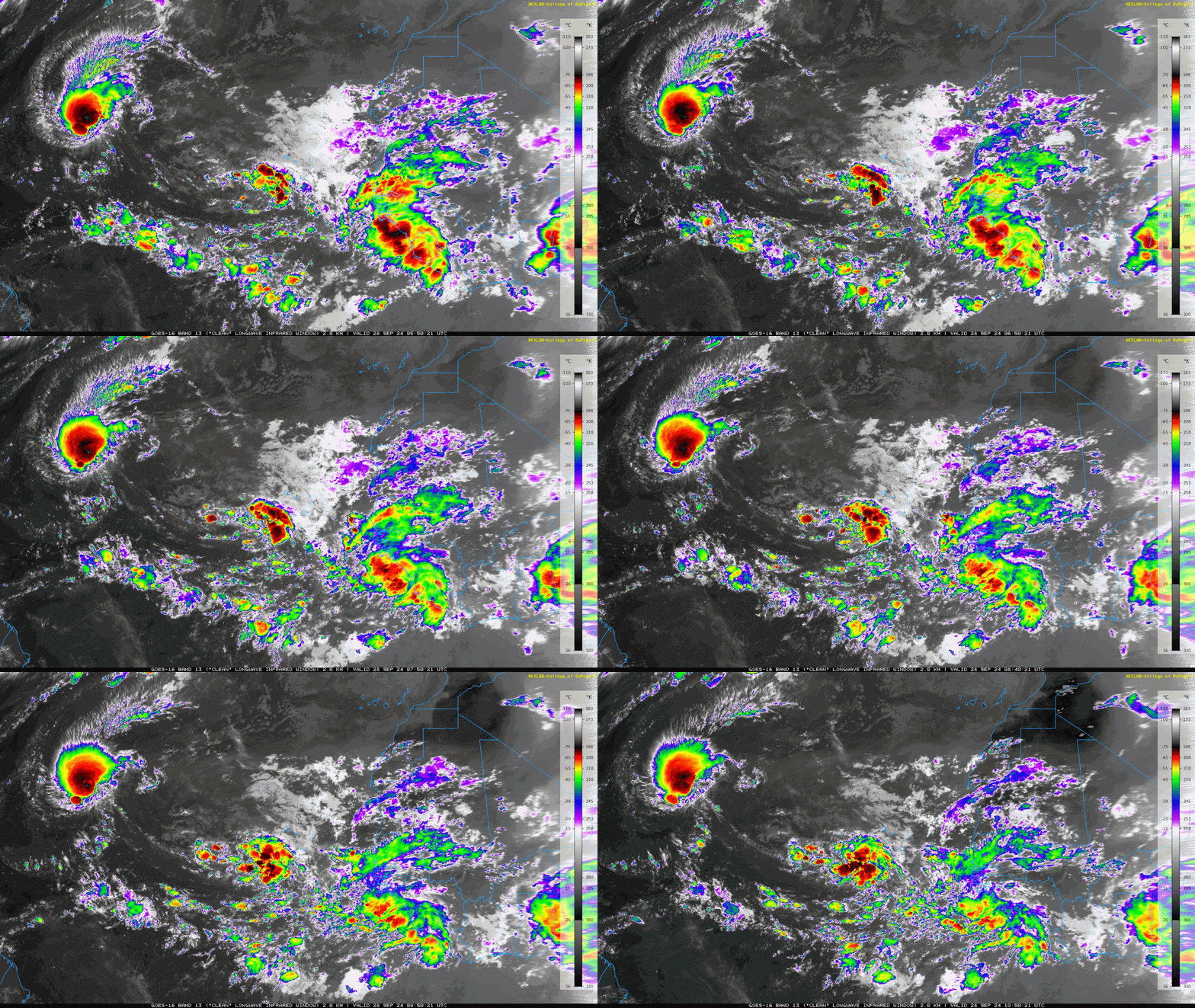
This could be invest 90L anytime today as it looking better as time goes by.

Image
3 likes   
Visit the Caribbean-Central America Weather Thread where you can find at first post web cams,radars
and observations from Caribbean basin members Click Here


Return to “Talkin' Tropics”

Who is online

Users browsing this forum: Long John and 91 guests