
AnnularCane wrote:Travorum wrote:18z GFS:
https://i.imgur.com/2fGw1bP.gif
What's it doing, coming back to give Florida a kiss before heading out?
Moderator: S2k Moderators

AnnularCane wrote:Travorum wrote:18z GFS:
https://i.imgur.com/2fGw1bP.gif
What's it doing, coming back to give Florida a kiss before heading out?


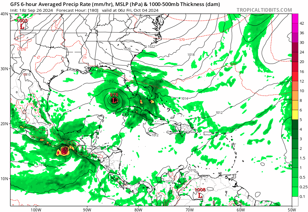
Teban54 wrote:AnnularCane wrote:Travorum wrote:18z GFS:
https://i.imgur.com/2fGw1bP.gif
What's it doing, coming back to give Florida a kiss before heading out?

https://i.postimg.cc/rFsCHKhF/gfs-mslp-pcpn-watl-fh180-324.gif
Category5Kaiju wrote:Looks like both GFS and CMC like the idea of this bombing out in the Gulf while stalling and then being slingshotted to the north/northeast. Unlike Helene, it looks like it may be more of a slow-mover.
Category5Kaiju wrote:Looks like both GFS and CMC like the idea of this bombing out in the Gulf while stalling and then being slingshotted to the north/northeast. Unlike Helene, it looks like it may be more of a slow-mover.

caneseddy wrote:Canadian has it landfalling in the Panhandle, but weak
Icon has nothing


Pipelines182 wrote:Hey, someone unplug the models and plug them back in, they're stuck on repeat, but seriously, can we not? I'm doubtful this potential storm would ground out in Mexico in October, but you never know. At least Helene did use up some energy in the western Caribbean, SSTs have dropped there (still plenty high), but the storm didn't do much in the GoM, just moving too fast at that point.
So let's see, Texas, Louisiana, and Florida have all gotten hurricanes this year. I guess next up in the GoM is Alabama/Mississippi, line up and get your licks as my granddad used to say.


BIFF_THE_UNRULY wrote:Travorum wrote:18z GFS:
https://i.imgur.com/2fGw1bP.gif
Oh man thats a tiny little storm


Users browsing this forum: Bing [Bot] and 232 guests

