Possible development in the Gulf of Mexico (Is Invest 92L)
Moderator: S2k Moderators
Forum rules

The posts in this forum are NOT official forecasts and should not be used as such. They are just the opinion of the poster and may or may not be backed by sound meteorological data. They are NOT endorsed by any professional institution or STORM2K. For official information, please refer to products from the National Hurricane Center and National Weather Service.
-
CrazyC83
- Professional-Met

- Posts: 34316
- Joined: Tue Mar 07, 2006 11:57 pm
- Location: Deep South, for the first time!
Re: Possible development in the Western Caribbean (0/50)
Interestingly, this could be stronger off the east coast, then the question is - does the trough axis go neutral and drive it inland further up the coast?
0 likes
-
ConvergenceZone
.gif)
- Category 5

- Posts: 5241
- Joined: Fri Jul 29, 2005 1:40 am
- Location: Northern California
Re: Possible development in the Western Caribbean (0/50)
Man, based on the EURO, this might be an even faster mover than Helene.
0 likes
Re: Possible development in the Western Caribbean (0/50)
CrazyC83 wrote:Interestingly, this could be stronger off the east coast, then the question is - does the trough axis go neutral and drive it inland further up the coast?
So what's up with these crazy 500mb storms that should be in November happening now?
2 likes
-
gatorcane

- S2K Supporter

- Posts: 23708
- Age: 48
- Joined: Sun Mar 13, 2005 3:54 pm
- Location: Boca Raton, FL
Re: Possible development in the Western Caribbean (0/50)
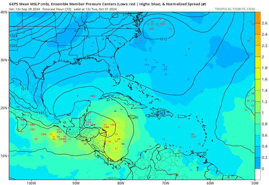
CMC ensembles are generally favoring the FL peninsula:
2 likes
Re: Possible development in the Western Caribbean (0/50)
gatorcane wrote:CMC ensembles are generally favoring the FL peninsula:
https://i.postimg.cc/s2vcz9JB/gem-ememb-lowlocs-watl-fh72-180.gif
So 6-7 days from now.
0 likes
-
Blown Away

- S2K Supporter
- Posts: 10253
- Joined: Wed May 26, 2004 6:17 am
Re: Possible development in the Western Caribbean (0/50)
gatorcane wrote:Saved 12Z Euro loop:
https://i.postimg.cc/VkKMdQV5/ec-fast-mslpa-Norm-watl-fh72-240.gif
What do you think Gatorcane, can we get more than a TS on that type of track??
0 likes
Hurricane Eye Experience: David 79, Irene 99, Frances 04, Jeanne 04, Wilma 05… Hurricane Brush Experience: Andrew 92, Erin 95, Floyd 99, Matthew 16, Irma 17, Ian 22, Nicole 22…

Re: Possible development in the Western Caribbean (0/40)
underthwx wrote:wxman57 wrote:Ah, another storm late next week? The setup looks quite different from Helene, and the models are seeing it, with the exception of the GFS. The upper-level pattern has shifted to fall across the Gulf. Models, except for the GFS, indicate a significant cold front moving south through the Gulf on Tuesday. Kind of similar to the setup before Francine, but with stronger west wind aloft across the northern Gulf - a less favorable environment. Whenever a cold front makes it south across the western Gulf, the air accelerates down the coast of Mexico, forming a natural wave on the front, usually east of Brownsville. The Euro, ICON, and Canadian see the front, though the Canadian adds some extra flair in the extended range. GFS doesn't see the front.
What's going to happen? I wouldn't go with the GFS solution, as it's almost always too aggressive with strengthening in this setup. Plus, it may be too weak with the front. Euro is generally too weak this far out. I'd go with the 00Z ICON solution. More of a frontal low in the central Gulf by next Saturday. With all the model support, I think a low will, indeed develop. I don't know if it'll be tropical enough for the NHC to name. Given the upper level flow, I'd say Florida will be in its sights. Hopefully, it's a weak low.
Meanwhile, I now have 5 more comp days to take, so I think I'll take Monday and Tuesday off. Kind of chilly outside this morning. It's 68 degrees! Better check the status of the heater. Have to let it warm up a bit before heading out for a long ride.
Thar works for me Xman!....and yes!....its chilly outside this morning....feels great!....enjoy your time off bro...
.
I see where the latest GFS has highs in the 60s and lows in the mid 40s the second week of October for the northern Gulf Coast. Keep it right there Mr GFS.
3 likes
-
johngaltfla

- Category 5
- Posts: 2073
- Joined: Sun Jul 10, 2005 9:17 pm
- Location: Sarasota County, FL
- Contact:
Re: RE: Re: Possible development in the Western Caribbean (0/40)
jlauderdal wrote:I hear ya, we can absorb some pain in SE Florida, we have had plenty of good fortune.Canelaw99 wrote:gatorcane wrote:MUCH stronger in the Gulf on the GFS. CMC is a bit stronger also. GFS shifts west and the CMC shifts east towards Florida
At this point, I, for one, will take the rain a storm brings if it means keeping it away from western NC and eastern TN.
We're sending you our bad fortune. You get all the snowbirds this season since our tourist destinations and beaches have been trashed. Enjoy the left turn signals in the left lane on I-95.
2 likes
-
gatorcane
- S2K Supporter
- Posts: 23708
- Age: 48
- Joined: Sun Mar 13, 2005 3:54 pm
- Location: Boca Raton, FL
Re: Possible development in the Western Caribbean (0/50)
Blown Away wrote:gatorcane wrote:Saved 12Z Euro loop:
https://i.postimg.cc/VkKMdQV5/ec-fast-mslpa-Norm-watl-fh72-240.gif
What do you think Gatorcane, can we get more than a TS on that type of track??
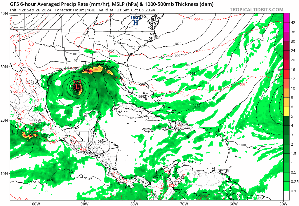
I think it's possible. The GFS shows a CAT 2/3 hurricane and has the system even further west than the Euro before the ENE turn, and it is likely too far west anyway. If we go back and look at historical tracks, would we find one that hits the peninsula as a hurricane on an ENE track from the Central Gulf?
3 likes
-
cajungal

- Category 5
- Posts: 2354
- Age: 49
- Joined: Sun Mar 14, 2004 9:34 pm
- Location: Schriever, Louisiana (60 miles southwest of New Orleans)
Re: Possible development in the Western Caribbean (0/50)
Just why? Yes I am tired here in SE Louisiana but love my Florida neighbors and they also need a break. Mother Nature just doesn’t care. It is relentless
5 likes


Re: Possible development in the Western Caribbean (0/50)
gatorcane wrote:Blown Away wrote:gatorcane wrote:Saved 12Z Euro loop:
https://i.postimg.cc/VkKMdQV5/ec-fast-mslpa-Norm-watl-fh72-240.gif
What do you think Gatorcane, can we get more than a TS on that type of track??
I think it's possible. The GFS shows a CAT 2/3 hurricane and has the system even further west than the Euro before the ENE turn, and it is likely too far west anyway. If we go back and look at historical tracks, would we find one that hits the peninsula as a hurricane on an ENE track from the Central Gulf?
https://i.postimg.cc/Pr4GV6wH/gfs-mslp-pcpn-watl-fh168-204.gif
Took a quick look through the historical tracks and found a few examples from the 1800s. All of these occurred late September/early October:

Last edited by Travorum on Sat Sep 28, 2024 3:52 pm, edited 1 time in total.
3 likes
-
johngaltfla
- Category 5
- Posts: 2073
- Joined: Sun Jul 10, 2005 9:17 pm
- Location: Sarasota County, FL
- Contact:
Re: Possible development in the Western Caribbean (0/50)
gatorcane wrote:Blown Away wrote:gatorcane wrote:Saved 12Z Euro loop:
https://i.postimg.cc/VkKMdQV5/ec-fast-mslpa-Norm-watl-fh72-240.gif
What do you think Gatorcane, can we get more than a TS on that type of track??
I think it's possible. The GFS shows a CAT 2/3 hurricane and has the system even further west than the Euro before the ENE turn, and it is likely too far west anyway. If we go back and look at historical tracks, would we find one that hits the peninsula as a hurricane on an ENE track from the Central Gulf?
https://i.postimg.cc/Pr4GV6wH/gfs-mslp-pcpn-watl-fh168-204.gif
Ask and ye shall receive:

That's the 1945 storm, peaked as a 2, landfall north of Tampa as a 1.
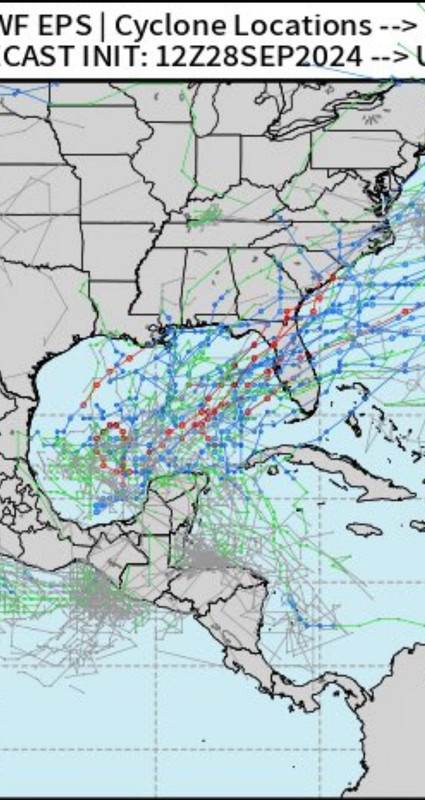
Here's the spaghetti of Cat 1 plus storms from NOAA:

4 likes
-
Stormcenter
- S2K Supporter
- Posts: 6689
- Joined: Wed Sep 03, 2003 11:27 am
- Location: Houston, TX
Re: Possible development in the Western Caribbean (0/50)
There is always going to be a first time for everything.
gatorcane wrote:Blown Away wrote:gatorcane wrote:Saved 12Z Euro loop:
https://i.postimg.cc/VkKMdQV5/ec-fast-mslpa-Norm-watl-fh72-240.gif
What do you think Gatorcane, can we get more than a TS on that type of track??
I think it's possible. The GFS shows a CAT 2/3 hurricane and has the system even further west than the Euro before the ENE turn, and it is likely too far west anyway. If we go back and look at historical tracks, would we find one that hits the peninsula as a hurricane on an ENE track from the Central Gulf?
https://i.postimg.cc/Pr4GV6wH/gfs-mslp-pcpn-watl-fh168-204.gif
1 likes
-
johngaltfla
- Category 5
- Posts: 2073
- Joined: Sun Jul 10, 2005 9:17 pm
- Location: Sarasota County, FL
- Contact:
Re: Possible development in the Western Caribbean (0/50)
cajungal wrote:Just why? Yes I am tired here in SE Louisiana but love my Florida neighbors and they also need a break. Mother Nature just doesn’t care. It is relentless
Thank you Cajun. We're whipped physically and financially down here. Debby was bad, Helene was bad, we don't ask what's next any more.
1 likes
-
jlauderdal
- S2K Supporter
- Posts: 7240
- Joined: Wed May 19, 2004 5:46 am
- Location: NE Fort Lauderdale
- Contact:
Re: Possible development in the Western Caribbean (0/50)
And they like to go right.SFLcane wrote:
1 likes
-
cajungal
- Category 5
- Posts: 2354
- Age: 49
- Joined: Sun Mar 14, 2004 9:34 pm
- Location: Schriever, Louisiana (60 miles southwest of New Orleans)
Re: Possible development in the Western Caribbean (0/50)
johngaltfla wrote:cajungal wrote:Just why? Yes I am tired here in SE Louisiana but love my Florida neighbors and they also need a break. Mother Nature just doesn’t care. It is relentless
Thank you Cajun. We're whipped physically and financially down here. Debby was bad, Helene was bad, we don't ask what's next any more.
We got floodwater in 2 rooms in our house because of a direct hit with Francine but complete heartbroken what my neighbors in Florida as well as TN and Carolina’s had to endure from Helene
5 likes

Re: Possible development in the Western Caribbean (0/50)
Where are all those people who were declaring thecseason dead? Lol We could use some rain north of Houston, but not even -removed-.
3 likes
Alicia, Rita, Ike, Harvey and Beryl...moved to Splendora lol
-
floridasun
- Tropical Storm

- Posts: 245
- Joined: Tue Sep 14, 2021 3:59 pm
Re: Possible development in the Western Caribbean (0/50)
florida cannot take other hit we have so many hit we need rest let hope next system stay as TS only
1 likes
-
eastcoastFL

- Category 5
- Posts: 3996
- Age: 44
- Joined: Thu Apr 12, 2007 12:29 pm
- Location: Palm City, FL
Re: Possible development in the Western Caribbean (0/50)
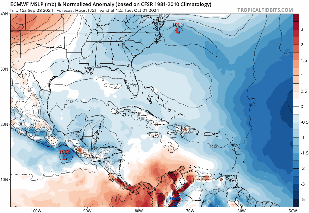
ColdMiser123 wrote:Euro has a 996 mb TS going into Tampa Bay.
A tropical wave passing to the north of the gyre can sometimes spark development off of it, which is why modeling is more aggressive on development overall compared to what you'd see from a typical GFS phantom gyre storm.
Doesn’t look like much as far as wind goes and surge shouldn’t be a major problem. But the rain could be a big issue from Tampa north, especially if it’s a prolonged rain event.
0 likes
Personal Forecast Disclaimer:
The posts in this forum are NOT official forecast and should not be used as such. They are just the opinion of the poster and may or may not be backed by sound meteorological data. They are NOT endorsed by any professional institution or storm2k.org. For official information, please refer to the NHC and NWS products.
The posts in this forum are NOT official forecast and should not be used as such. They are just the opinion of the poster and may or may not be backed by sound meteorological data. They are NOT endorsed by any professional institution or storm2k.org. For official information, please refer to the NHC and NWS products.
Who is online
Users browsing this forum: ljmac75 and 224 guests