2024 Global Model Runs Discussion (Out thru day 16)

This is the general tropical discussion area. Anyone can take their shot at predicting a storms path.

Moderator: S2k Moderators

Forum rules

The posts in this forum are NOT official forecasts and should not be used as such. They are just the opinion of the poster and may or may not be backed by sound meteorological data. They are NOT endorsed by any professional institution or STORM2K. For official information, please refer to products from the National Hurricane Center and National Weather Service.

Help Support Storm2K
Message
Author
xironman
S2K Supporter
S2K Supporter
Posts: 2522
Joined: Sun Jun 10, 2007 4:53 pm
Location: NoVA

Re: 2024 Global Model Runs Discussion (Out thru day 16)

#2161 Postby xironman » Sat Sep 28, 2024 5:20 am

kevin wrote:06z ICON has 4 TCs at +120 hrs.
*The current disturbance in the eastern MDR is an intensifying cat 1, a little further south than in 00z.
*The WCar disturbance as a 1004 mb TS in the GOM.
*Another wave behind the MDR disturbance becomes a TS. Many models have been hinting at a couple more MDR waves.
*A STS east of the US.

https://i.imgur.com/HQylxWD.png


2024 is a late bloomer
0 likes   

User avatar
kevin
Category 5
Category 5
Posts: 2586
Age: 26
Joined: Wed Aug 28, 2019 4:35 am

Re: 2024 Global Model Runs Discussion (Out thru day 16)

#2162 Postby kevin » Sat Sep 28, 2024 5:21 am

06z GFS +180 hrs.

Image
2 likes   

User avatar
Travorum
Category 1
Category 1
Posts: 406
Joined: Tue Sep 05, 2023 9:36 am
Location: Dunedin, FL

Re: 2024 Global Model Runs Discussion (Out thru day 16)

#2163 Postby Travorum » Sat Sep 28, 2024 12:29 pm

12z ICON continues to develop the wave behind the current MDR disturbance, keeps it pretty far south.

Image
1 likes   

Stratton23
Category 5
Category 5
Posts: 2519
Joined: Fri Jul 21, 2023 10:59 pm
Location: Katy, Tx

Re: 2024 Global Model Runs Discussion (Out thru day 16)

#2164 Postby Stratton23 » Sat Sep 28, 2024 7:35 pm

18z GFS has a weak TS off the texas coast at hour 138, what the heck is that from?
0 likes   

User avatar
Teban54
Category 5
Category 5
Posts: 3204
Joined: Sat May 19, 2018 1:19 pm

Re: 2024 Global Model Runs Discussion (Out thru day 16)

#2165 Postby Teban54 » Sun Sep 29, 2024 12:29 am

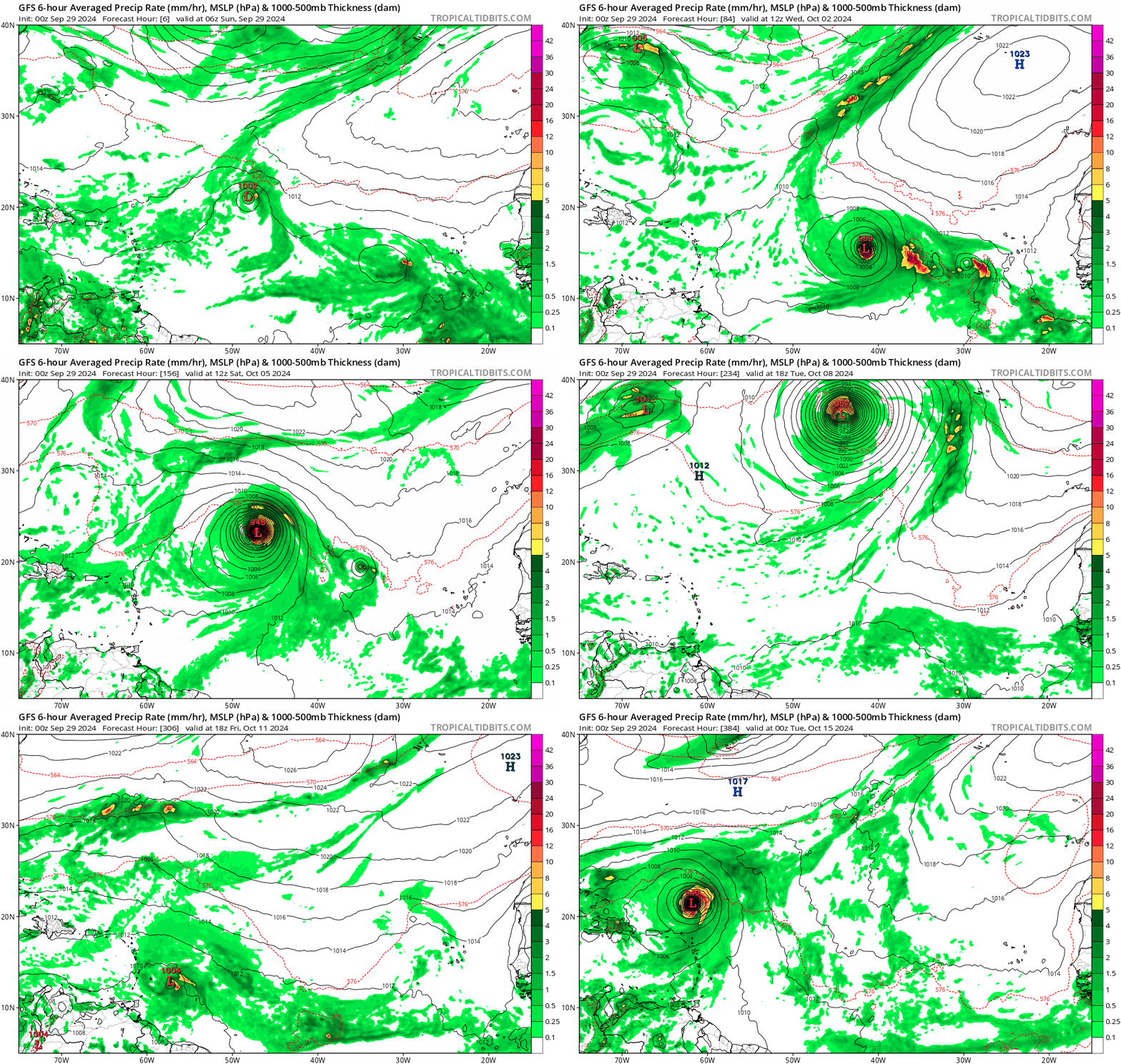
Long range and will probably be gone the next run, but 0z GFS has a western MDR TS/Cat 1 entering the Caribbean, bombing out in NE Caribbean to a major, and recurving out. Basically a stronger Tammy/Tomas or a Matthew but much further east.

Also, earlier in the run it has another TC just behind 90L, which peaks in the upper 990s before getting sheared by 90L. While it may be convective feedback, ICON has shown this one also developing in recent runs (although ironically 0z ICON is much weaker with this one than earlier).

(Edit: Replaced loop with one that's more zoomed in.)

Image
4 likes   

User avatar
Teban54
Category 5
Category 5
Posts: 3204
Joined: Sat May 19, 2018 1:19 pm

Re: 2024 Global Model Runs Discussion (Out thru day 16)

#2166 Postby Teban54 » Wed Oct 02, 2024 5:52 pm

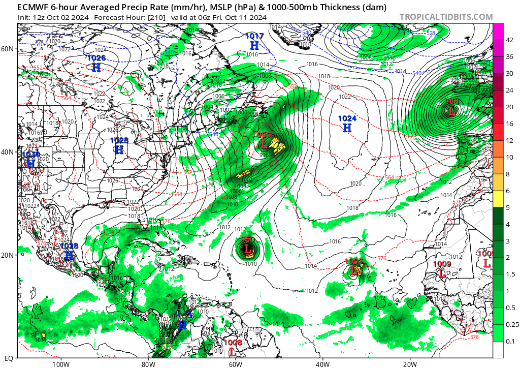
This is not Kirk and TD13... This is "TD" 13 and the next wave.

Both Euro and CMC have the next wave as of 12z. They both keep it weak, but still, that would certainly be the most legendary October MDR season ever.
Image
5 likes   

User avatar
Hypercane_Kyle
Category 5
Category 5
Posts: 3352
Joined: Sat Mar 07, 2015 7:58 pm
Location: Cape Canaveral, FL

Re: 2024 Global Model Runs Discussion (Out thru day 16)

#2167 Postby Hypercane_Kyle » Wed Oct 02, 2024 7:13 pm

I'm starting to see some very broad model support for conditions being favorable in the western Caribbean towards the middle of October, probably as a result of that front predicted to shear the GOMEX disturbance lingering in the Caribbean. Way, way too far out to even speculate if it'll happen, but something to keep an eye on.
4 likes   
My posts are my own personal opinion, defer to the National Hurricane Center (NHC) and other NOAA products for decision making during hurricane season.

WeatherBoy2000
Category 1
Category 1
Posts: 346
Joined: Mon Apr 10, 2023 9:29 am

Re: 2024 Global Model Runs Discussion (Out thru day 16)

#2168 Postby WeatherBoy2000 » Wed Oct 02, 2024 7:23 pm

Hypercane_Kyle wrote:I'm starting to see some very broad model support for conditions being favorable in the western Caribbean towards the middle of October, probably as a result of that front predicted to shear the GOMEX disturbance lingering in the Caribbean. Way, way too far out to even speculate if it'll happen, but something to keep an eye on.


The gfs/euro AIFS has a storm develop around the 15th-18th timeframe.
1 likes   

User avatar
Kazmit
Category 5
Category 5
Posts: 2124
Age: 22
Joined: Mon Jul 25, 2016 8:49 am
Location: Williamsburg, VA / Bermuda

Re: 2024 Global Model Runs Discussion (Out thru day 16)

#2169 Postby Kazmit » Thu Oct 03, 2024 9:09 am

GFS has a MH heading NW in the western Caribbean way out in the fantasy range. Probably just a phantom but we will need to start looking towards the western Caribbean as we head later into October as it is an obvious hotspot that time of year.

Image
2 likes   
Igor 2010, Sandy 2012, Fay 2014, Gonzalo 2014, Joaquin 2015, Nicole 2016, Humberto 2019

I am only a tropical weather enthusiast. My predictions are not official and may or may not be backed by sound meteorological data. For official information, please refer to the NHC and NWS products.

User avatar
N2FSU
S2K Supporter
S2K Supporter
Posts: 1062
Joined: Thu Sep 04, 2003 2:04 pm
Location: Tallahassee, FL

Re: 2024 Global Model Runs Discussion (Out thru day 16)

#2170 Postby N2FSU » Thu Oct 03, 2024 12:01 pm

12z Canadian 120H
Image


Sent from my iPad using Tapatalk
0 likes   

User avatar
N2FSU
S2K Supporter
S2K Supporter
Posts: 1062
Joined: Thu Sep 04, 2003 2:04 pm
Location: Tallahassee, FL

Re: 2024 Global Model Runs Discussion (Out thru day 16)

#2171 Postby N2FSU » Thu Oct 03, 2024 12:02 pm

12z Canadian 234H

Image


Sent from my iPad using Tapatalk
0 likes   

User avatar
Blinhart
Category 5
Category 5
Posts: 2079
Age: 48
Joined: Thu Sep 08, 2011 3:13 pm
Location: Crowley, La.

Re: 2024 Global Model Runs Discussion (Out thru day 16)

#2172 Postby Blinhart » Fri Oct 04, 2024 4:40 am

When should we expect a lemon for the wave coming off Africa right now?
0 likes   
Personal Forecast Disclaimer:
The posts in this forum are NOT official forecast and should not be used as such. They are just the opinion of the poster and may or may not be backed by sound meteorological data. They are NOT endorsed by any professional institution or storm2k.org. For official information, please refer to the NHC and NWS products.

ChrisH-UK
Category 2
Category 2
Posts: 625
Joined: Sat May 29, 2021 8:22 am

Re: 2024 Global Model Runs Discussion (Out thru day 16)

#2173 Postby ChrisH-UK » Fri Oct 04, 2024 6:00 am

Looks like we wil be getting another MDR storm as well as a storm in the Gulf taking aim at Florida with in the next 10 days. The GEM model has the Gulf storm stalling due to a high on the east coast the other models have the same high but not further east.

Image
Image
Image
1 likes   

User avatar
Category5Kaiju
Category 5
Category 5
Posts: 4097
Joined: Thu Dec 24, 2020 12:45 pm
Location: Seattle

Re: 2024 Global Model Runs Discussion (Out thru day 16)

#2174 Postby Category5Kaiju » Fri Oct 04, 2024 6:52 am

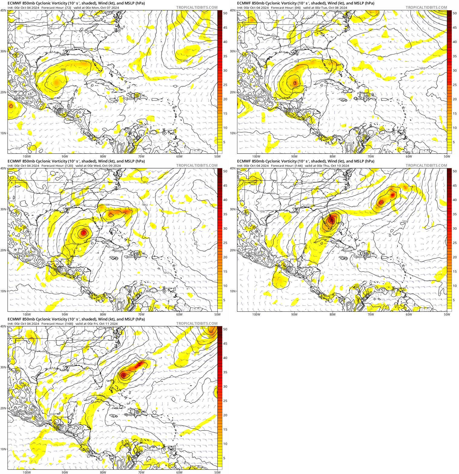
ECMWF ensembles are still very optimistic about the current Gulf disturbance developing, as well as yet another MDR disturbance that exits the African Coast while Leslie is bombing out. That could put us at 14 NSs by mid-month, and there's no telling what kind of activity we will get late month and November (I'm willing to bet we will see several more storms, at least one of which becomes a significant system).
3 likes   
Unless explicitly stated, all info in my posts is based on my own opinions and observations. Tropical storms and hurricanes can be extremely dangerous. Do not think you can beat Mother Nature. Refer to an accredited weather research agency or meteorologist if you need to make serious decisions regarding an approaching storm.

User avatar
Blown Away
S2K Supporter
S2K Supporter
Posts: 10145
Joined: Wed May 26, 2004 6:17 am

Re: 2024 Global Model Runs Discussion (Out thru day 16)

#2175 Postby Blown Away » Fri Oct 04, 2024 7:45 am

Category5Kaiju wrote:ECMWF ensembles are still very optimistic about the current Gulf disturbance developing, as well as yet another MDR disturbance that exits the African Coast while Leslie is bombing out. That could put us at 14 NSs by mid-month, and there's no telling what kind of activity we will get late month and November (I'm willing to bet we will see several more storms, at least one of which becomes a significant system).


Image
00z EURO...
0 likes   
Hurricane Eye Experience: David 79, Irene 99, Frances 04, Jeanne 04, Wilma 05... EYE COMING MY WAY IN 2024…
Hurricane Brush Experience: Andrew 92, Erin 95, Floyd 99, Matthew 16, Irma 17, Ian 22, Nicole 22…

User avatar
toad strangler
S2K Supporter
S2K Supporter
Posts: 4543
Joined: Sun Jul 28, 2013 3:09 pm
Location: Earth
Contact:

Re: 2024 Global Model Runs Discussion (Out thru day 16)

#2176 Postby toad strangler » Fri Oct 04, 2024 8:33 am

Blown Away wrote:
Category5Kaiju wrote:ECMWF ensembles are still very optimistic about the current Gulf disturbance developing, as well as yet another MDR disturbance that exits the African Coast while Leslie is bombing out. That could put us at 14 NSs by mid-month, and there's no telling what kind of activity we will get late month and November (I'm willing to bet we will see several more storms, at least one of which becomes a significant system).


[url]https://i.postimg.cc/vmBZk5RT/ec-fast-uv850-vort-watl-fh72-168.gif [/url]
00z EURO...


Name storm count and ACE will still most likely come under pre-season forecasts but if this run verifies for the most part, the much ballyhooed BUST is going to be the BUST itself :lol
5 likes   

User avatar
Hurrilurker
Category 2
Category 2
Posts: 719
Joined: Mon Jun 09, 2003 3:32 pm
Location: San Francisco, CA

Re: 2024 Global Model Runs Discussion (Out thru day 16)

#2177 Postby Hurrilurker » Fri Oct 04, 2024 3:56 pm

Looks like the UK is likely to see some pretty serious impacts.
0 likes   

al78
Professional-Met
Professional-Met
Posts: 332
Joined: Thu Nov 01, 2018 12:20 pm

Re: 2024 Global Model Runs Discussion (Out thru day 16)

#2178 Postby al78 » Fri Oct 04, 2024 4:09 pm

Hurrilurker wrote:Looks like the UK is likely to see some pretty serious impacts.


The UK is seeing some serious impacts from the over-hyped and ridiculous click-bait media headlines that always pop up every time the remnants of a hurricane move across the UK.

https://www.gbnews.com/weather/uk-weath ... rk-britain
1 likes   

al78
Professional-Met
Professional-Met
Posts: 332
Joined: Thu Nov 01, 2018 12:20 pm

Re: 2024 Global Model Runs Discussion (Out thru day 16)

#2179 Postby al78 » Fri Oct 04, 2024 4:13 pm

toad strangler wrote:
Blown Away wrote:
Category5Kaiju wrote:ECMWF ensembles are still very optimistic about the current Gulf disturbance developing, as well as yet another MDR disturbance that exits the African Coast while Leslie is bombing out. That could put us at 14 NSs by mid-month, and there's no telling what kind of activity we will get late month and November (I'm willing to bet we will see several more storms, at least one of which becomes a significant system).


[url]https://i.postimg.cc/vmBZk5RT/ec-fast-uv850-vort-watl-fh72-168.gif [/url]
00z EURO...


Name storm count and ACE will still most likely come under pre-season forecasts but if this run verifies for the most part, the much ballyhooed BUST is going to be the BUST itself :lol


We are almost up to the year-to-date climatological mean for ACE but I would put money on a hyper-active season not verifying. Nonetheless, although the seasonal forecasts were wrong, they weren't necessarily useless as impacts have been comparable to past hyper-active seasons even if the overall quantitative stats are well down, so it could be argued that seasonal forecasts this year may have helped businesses to make better decisions in advance if those businesses had acted on them.
4 likes   

ChrisH-UK
Category 2
Category 2
Posts: 625
Joined: Sat May 29, 2021 8:22 am

Re: 2024 Global Model Runs Discussion (Out thru day 16)

#2180 Postby ChrisH-UK » Fri Oct 04, 2024 5:22 pm

al78 wrote:
Hurrilurker wrote:Looks like the UK is likely to see some pretty serious impacts.


The UK is seeing some serious impacts from the over-hyped and ridiculous click-bait media headlines that always pop up every time the remnants of a hurricane move across the UK.

https://www.gbnews.com/weather/uk-weath ... rk-britain


Well that's the stupid news media, here in UK they are well know and laughed at. As for the storms were use to the wind and rain, we have a long winter storm season to go.
0 likes   


Return to “Talkin' Tropics”

Who is online

Users browsing this forum: Bobbyh83, jgh, southmdwatcher, USTropics and 42 guests