WPAC: KRATHON - Post-Tropical

Moderator: S2k Moderators

Message
Author
User avatar
xtyphooncyclonex
Category 5
Category 5
Posts: 3857
Age: 23
Joined: Sat Dec 08, 2012 9:07 am
Location: Cebu City
Contact:

Re: WPAC: KRATHON - Tropical Storm

#21 Postby xtyphooncyclonex » Sun Sep 29, 2024 12:18 am

Officially a typhoon

T2418(Krathon)
Issued at 2024/09/29 04:10 UTC
Analysis at 09/29 03 UTC
Grade TY
Scale -
Intensity -
Center position N19°00′ (19.0°)
E124°20′ (124.3°)
Direction and speed of movement NNW Slow
Central pressure 975 hPa
Maximum sustained wind speed near center 35 m/s (65 kt)
Maximum wind gust speed 50 m/s (95 kt)
Radius of 50-kt wind area 110 km (60 NM)
Radius of 30-kt wind area 440 km (240 NM)


ADT going bonkers. Krathon is exploding they say

UW - CIMSS
ADVANCED DVORAK TECHNIQUE
ADT-Version 9.1
Tropical Cyclone Intensity Algorithm

----- Current Analysis -----
Date : 29 SEP 2024 Time : 044000 UTC
Lat : 18:51:04 N Lon : 123:59:18 E


CI# /Pressure/ Vmax
5.3 / 959.6mb/ 97.2kt


Final T# Adj T# Raw T#
5.3 5.2 5.2

Estimated radius of max. wind based on IR :N/A km

Center Temp : -31.8C Cloud Region Temp : -64.7C

Scene Type : EYE

Subtropical Adjustment : OFF

Extratropical Adjustment : OFF

Positioning Method : FORECAST INTERPOLATION

Ocean Basin : WEST PACIFIC
Dvorak CI > MSLP Conversion Used : CKZ Method

Tno/CI Rules : Constraint Limits : NO LIMIT
Weakening Flag : OFF
Rapid Dissipation Flag : OFF

C/K/Z MSLP Estimate Inputs :
- Average 34 knot radii : 91nmi
- Environmental MSLP : 1008mb

Satellite Name : HIM-9
Satellite Viewing Angle : 29.2 degrees
0 likes   
REMINDER: My opinions that I, or any other NON Pro-Met in this forum, are unofficial. Please do not take my opinions as an official forecast and warning. I am NOT a meteorologist. Following my forecasts blindly may lead to false alarm, danger and risk if official forecasts from agencies are ignored.

User avatar
Hayabusa
Category 5
Category 5
Posts: 4244
Joined: Sun Sep 16, 2018 1:05 pm

Re: WPAC: KRATHON - Typhoon

#22 Postby Hayabusa » Sun Sep 29, 2024 1:20 am

SMAP pass around 28/22z == 85 knots
WP, 20, 202409282208, 30, SMAP, IR, , 1870N, 12430E, , 1, 79, 1, , , , 34, NEQ, 0, 0, 146, 87, , , , , 1, 0, , W, NASA, RSS, , , , , , , , , , , , , , , , , , , , , , , , , , , , 1, max. wind is 10 minute sustained
WP, 20, 202409282208, 30, SMAP, IR, , 1870N, 12430E, , 1, 79, 1, , , , 50, NEQ, 0, 0, 0, 43, , , , , 1, 0, , W, NASA, RSS, , , , , , , , , , , , , , , , , , , , , , , , , , , , 1, max. wind is 10 minute sustained
WP, 20, 202409282208, 30, SMAP, IR, , 1870N, 12430E, , 1, 79, 1, , , , 64, NEQ, 0, 0, 0, 0, , , , , 1, 0, , W, NASA, RSS, , , , , , , , , , , , , , , , , , , , , , , , , , , , 1, max. wind is 10 minute sustained
0 likes   
ヤンデレ女が寝取られるているのを見たい!!!
ECMWF ensemble NWPAC plots: https://ecmwfensnwpac.imgbb.com/
Multimodel NWPAC plots: https://multimodelnwpac.imgbb.com/
GFS Ensemble NWPAC plots (16 & 35 day forecast): https://gefsnwpac.imgbb.com/
Plots updated automatically

User avatar
cycloneye
Admin
Admin
Posts: 143863
Age: 68
Joined: Thu Oct 10, 2002 10:54 am
Location: San Juan, Puerto Rico

Re: WPAC: KRATHON - Typhoon

#23 Postby cycloneye » Sun Sep 29, 2024 1:19 pm

1 likes   
Visit the Caribbean-Central America Weather Thread where you can find at first post web cams,radars
and observations from Caribbean basin members Click Here

User avatar
Travorum
Category 1
Category 1
Posts: 406
Joined: Tue Sep 05, 2023 9:36 am
Location: Dunedin, FL

Re: WPAC: KRATHON - Typhoon

#24 Postby Travorum » Sun Sep 29, 2024 2:03 pm

ADT has raw T# up to 6.7 now:
UW - CIMSS
ADVANCED DVORAK TECHNIQUE
ADT-Version 9.1
Tropical Cyclone Intensity Algorithm

----- Current Analysis -----
Date : 29 SEP 2024 Time : 183000 UTC
Lat : 19:55:48 N Lon : 122:24:36 E


CI# /Pressure/ Vmax
6.3 / 937.2mb/122.2kt


Final T# Adj T# Raw T#
6.3 6.7 6.7

Estimated radius of max. wind based on IR :N/A km

Center Temp : +15.2C Cloud Region Temp : -74.5C

Scene Type : EYE

Subtropical Adjustment : OFF

Extratropical Adjustment : OFF

Positioning Method : ARCHER POSITIONING

Ocean Basin : WEST PACIFIC
Dvorak CI > MSLP Conversion Used : CKZ Method

Tno/CI Rules : Constraint Limits : NO LIMIT
Weakening Flag : OFF
Rapid Dissipation Flag : OFF

C/K/Z MSLP Estimate Inputs :
- Average 34 knot radii : 117nmi
- Environmental MSLP : 1008mb

Satellite Name : HIM-9
Satellite Viewing Angle : 31.2 degrees
0 likes   

User avatar
cycloneye
Admin
Admin
Posts: 143863
Age: 68
Joined: Thu Oct 10, 2002 10:54 am
Location: San Juan, Puerto Rico

Re: WPAC: KRATHON - Typhoon

#25 Postby cycloneye » Sun Sep 29, 2024 2:38 pm

Wow. Taiwan will get a lot of rain and wind.

Image
5 likes   
Visit the Caribbean-Central America Weather Thread where you can find at first post web cams,radars
and observations from Caribbean basin members Click Here

User avatar
Hurricane2022
Category 5
Category 5
Posts: 1496
Joined: Tue Aug 23, 2022 11:38 pm
Location: Araçatuba, Brazil

Re: WPAC: KRATHON - Typhoon

#26 Postby Hurricane2022 » Sun Sep 29, 2024 2:53 pm

ImageImage
0 likes   
Sorry for the bad English sometimes...!
For reliable and detailed information for any meteorological phenomenon, please consult the National Hurricane Center, Joint Typhoon Warning Center , or your local Meteo Center.

--------

Una cvm Christo, pro Christo, et in Christo. Sit nomen Domini benedictvm.

User avatar
1900hurricane
Category 5
Category 5
Posts: 6059
Age: 34
Joined: Fri Feb 06, 2015 12:04 pm
Location: Houston, TX
Contact:

Re: WPAC: KRATHON - Typhoon

#27 Postby 1900hurricane » Sun Sep 29, 2024 7:38 pm

Anyone have obs from Basco?
0 likes   
Contract Meteorologist. TAMU & MSST. Fiercely authentic, one of a kind. We are all given free will, so choose a life meant to be lived. We are the Masters of our own Stories.
Opinions expressed are mine alone.

Follow me on Twitter at @1900hurricane : Read blogs at https://1900hurricane.wordpress.com/

User avatar
doomhaMwx
Category 5
Category 5
Posts: 2454
Age: 26
Joined: Tue Apr 18, 2017 4:01 am
Location: Baguio/Benguet, Philippines
Contact:

Re: WPAC: KRATHON - Typhoon

#28 Postby doomhaMwx » Sun Sep 29, 2024 8:20 pm

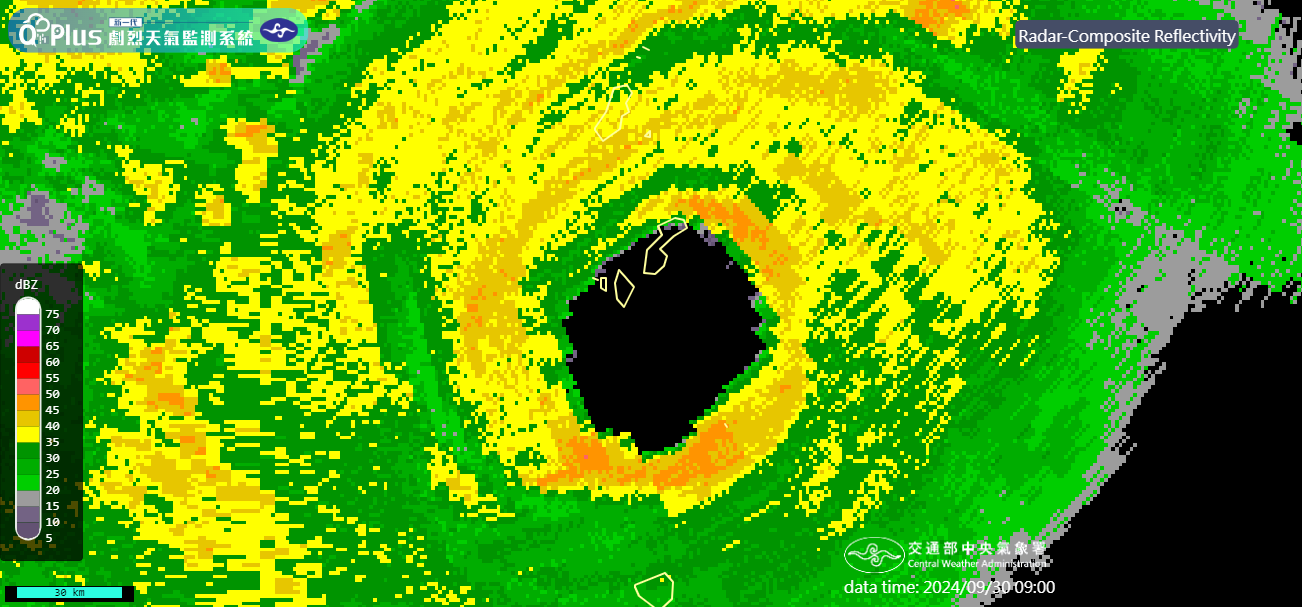
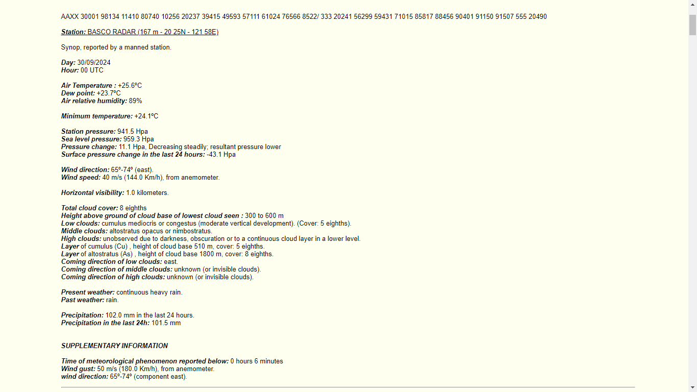
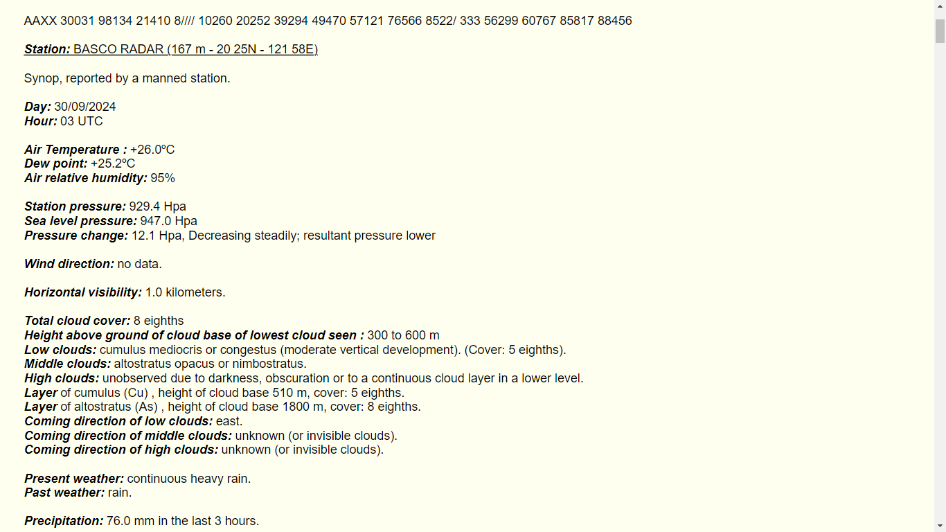
The southern portions of the Batanes Islands are now in the eye. At 00Z, PAGASA Basco station recorded an MSLP of 959.3 mb with sustained winds of 144 kph (78 kts) gusting to 180 kph (97 kts) in the eyewall!

Image
Image

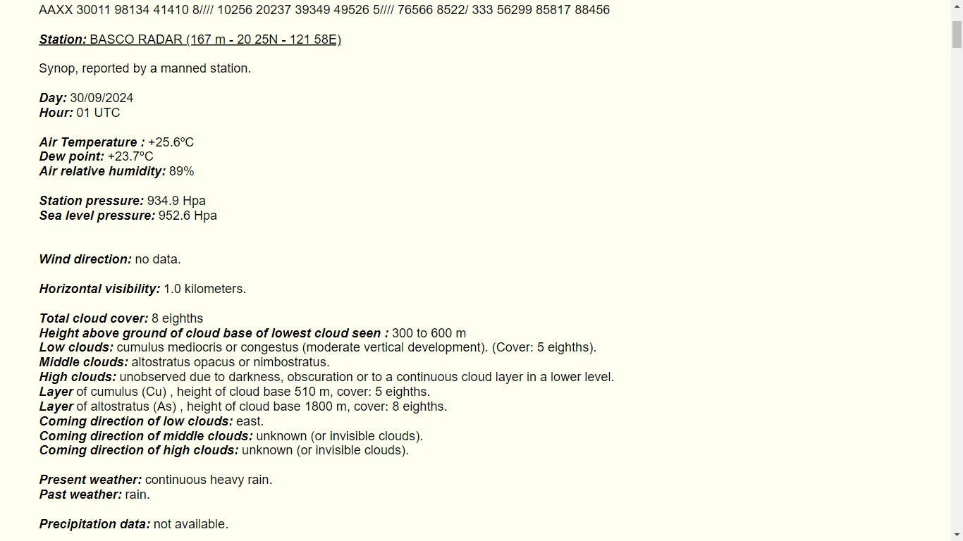
Update: MSLP at Basco station further dropped to 952.6 mb at 01Z.

Image
4 likes   

User avatar
doomhaMwx
Category 5
Category 5
Posts: 2454
Age: 26
Joined: Tue Apr 18, 2017 4:01 am
Location: Baguio/Benguet, Philippines
Contact:

Re: WPAC: KRATHON - Typhoon

#29 Postby doomhaMwx » Sun Sep 29, 2024 11:18 pm

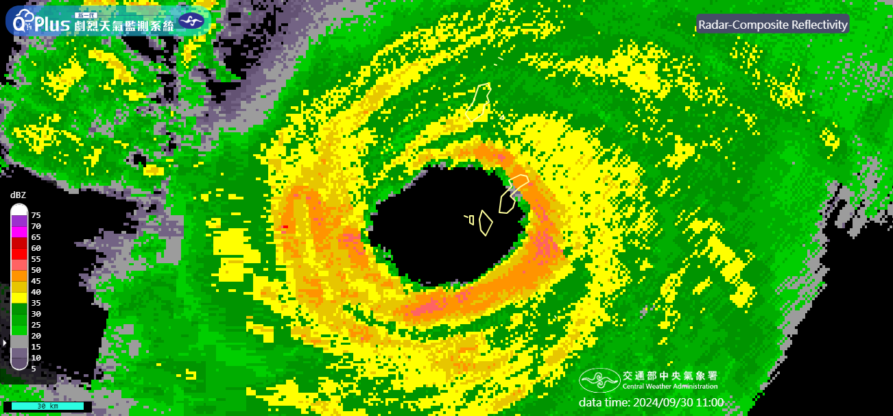
Interestingly, pressure at Basco has continued to decrease despite Krathon's eye now moving away. At 03Z, a 947 mb MSLP was recorded near the edge of the eye/eyewall (and still decreasing at that time as per the synop report) — indicating that the typhoon continues to intensify!

Image
Image
0 likes   

User avatar
Hayabusa
Category 5
Category 5
Posts: 4244
Joined: Sun Sep 16, 2018 1:05 pm

Re: WPAC: KRATHON - Typhoon

#30 Postby Hayabusa » Mon Sep 30, 2024 10:48 am

Up to 125 kts
20W KRATHON 240930 1200 20.5N 120.5E WPAC 125 932
1 likes   
ヤンデレ女が寝取られるているのを見たい!!!
ECMWF ensemble NWPAC plots: https://ecmwfensnwpac.imgbb.com/
Multimodel NWPAC plots: https://multimodelnwpac.imgbb.com/
GFS Ensemble NWPAC plots (16 & 35 day forecast): https://gefsnwpac.imgbb.com/
Plots updated automatically

User avatar
ElectricStorm
Category 5
Category 5
Posts: 5017
Age: 24
Joined: Tue Aug 13, 2019 11:23 pm
Location: Skiatook, OK / Norman, OK

Re: WPAC: KRATHON - Typhoon

#31 Postby ElectricStorm » Mon Sep 30, 2024 11:39 am

Eye is struggling to clear so far but other than that it looks pretty good. Hope it's not too destructive for Taiwan
0 likes   
I am in no way a professional. Take what I say with a grain of salt as I could be totally wrong. Please refer to the NHC, NWS, or SPC for official information.

Boomer Sooner!

User avatar
Hayabusa
Category 5
Category 5
Posts: 4244
Joined: Sun Sep 16, 2018 1:05 pm

Re: WPAC: KRATHON - Typhoon

#32 Postby Hayabusa » Mon Sep 30, 2024 12:42 pm

2024SEP30 170000 6.6 927.3 129.6 6.6 7.0 7.0 NO LIMIT OFF OFF OFF OFF 7.74 -76.99 EYE -99 IR 60.0 20.44 -120.11 ARCHER HIM-9 33.4
0 likes   
ヤンデレ女が寝取られるているのを見たい!!!
ECMWF ensemble NWPAC plots: https://ecmwfensnwpac.imgbb.com/
Multimodel NWPAC plots: https://multimodelnwpac.imgbb.com/
GFS Ensemble NWPAC plots (16 & 35 day forecast): https://gefsnwpac.imgbb.com/
Plots updated automatically

User avatar
ElectricStorm
Category 5
Category 5
Posts: 5017
Age: 24
Joined: Tue Aug 13, 2019 11:23 pm
Location: Skiatook, OK / Norman, OK

Re: WPAC: KRATHON - Typhoon

#33 Postby ElectricStorm » Mon Sep 30, 2024 1:54 pm

20W KRATHON 240930 1800 20.6N 120.0E WPAC 130 927
0 likes   
I am in no way a professional. Take what I say with a grain of salt as I could be totally wrong. Please refer to the NHC, NWS, or SPC for official information.

Boomer Sooner!

underthwx
Category 5
Category 5
Posts: 2351
Joined: Sat Jul 30, 2011 2:14 pm
Location: Brazoria County Texas

Re: WPAC: KRATHON - Typhoon

#34 Postby underthwx » Mon Sep 30, 2024 1:56 pm

ElectricStorm wrote:Eye is struggling to clear so far but other than that it looks pretty good. Hope it's not too destructive for Taiwan

I echo that....will the typhoon track directly over the length of Taiwan?...
0 likes   

User avatar
cycloneye
Admin
Admin
Posts: 143863
Age: 68
Joined: Thu Oct 10, 2002 10:54 am
Location: San Juan, Puerto Rico

Re: WPAC: KRATHON - Typhoon

#35 Postby cycloneye » Mon Sep 30, 2024 6:38 pm

0 likes   
Visit the Caribbean-Central America Weather Thread where you can find at first post web cams,radars
and observations from Caribbean basin members Click Here

User avatar
Hayabusa
Category 5
Category 5
Posts: 4244
Joined: Sun Sep 16, 2018 1:05 pm

Re: WPAC: KRATHON - Typhoon

#36 Postby Hayabusa » Mon Sep 30, 2024 7:24 pm

Up to 135 - 140???, sidenote MET is 7.5 the T number that is rarely used :lol:
TPPN13 PGTW 302359

A. SUPER TYPHOON 20W (KRATHON)

B. 30/2340Z

C. 20.59N

D. 119.66E

E. ONE/GK2A

F. T7.0/7.0/D1.0/24HRS STT: S0.0/03HRS

G. IR/EIR/VIS/MSI

H. REMARKS: 03A/PBO EYE/ANMTN. WMG EYE SURROUNDED BY W YIELDS AN E#
OF 6.0. ADDED 1.0 EYE ADJUSTMENT FOR W, TO YIELD A DT OF 7.0. MET
YIELDS 7.5. PT YIELDS 7.0. DBO DT

I. ADDITIONAL POSITIONS: NONE


FLEWALLEN
0 likes   
ヤンデレ女が寝取られるているのを見たい!!!
ECMWF ensemble NWPAC plots: https://ecmwfensnwpac.imgbb.com/
Multimodel NWPAC plots: https://multimodelnwpac.imgbb.com/
GFS Ensemble NWPAC plots (16 & 35 day forecast): https://gefsnwpac.imgbb.com/
Plots updated automatically

User avatar
Hayabusa
Category 5
Category 5
Posts: 4244
Joined: Sun Sep 16, 2018 1:05 pm

Re: WPAC: KRATHON - Typhoon

#37 Postby Hayabusa » Mon Sep 30, 2024 8:17 pm

Holy cow, Basco reported 728 mm rainfall for the past 24 hrs :double:
Image
0 likes   
ヤンデレ女が寝取られるているのを見たい!!!
ECMWF ensemble NWPAC plots: https://ecmwfensnwpac.imgbb.com/
Multimodel NWPAC plots: https://multimodelnwpac.imgbb.com/
GFS Ensemble NWPAC plots (16 & 35 day forecast): https://gefsnwpac.imgbb.com/
Plots updated automatically

User avatar
Hayabusa
Category 5
Category 5
Posts: 4244
Joined: Sun Sep 16, 2018 1:05 pm

Re: WPAC: KRATHON - Typhoon

#38 Postby Hayabusa » Mon Sep 30, 2024 8:29 pm

Hayabusa wrote:Holy cow, Basco reported 728 mm rainfall for the past 24 hrs :double:
https://i.imgur.com/R7aCWAQ.png

This is what made it a record... yesterday the 09/30/06z synop report, Basco reported a 659 mm of rainfall in just 6 hrs
Image
0 likes   
ヤンデレ女が寝取られるているのを見たい!!!
ECMWF ensemble NWPAC plots: https://ecmwfensnwpac.imgbb.com/
Multimodel NWPAC plots: https://multimodelnwpac.imgbb.com/
GFS Ensemble NWPAC plots (16 & 35 day forecast): https://gefsnwpac.imgbb.com/
Plots updated automatically

User avatar
Hayabusa
Category 5
Category 5
Posts: 4244
Joined: Sun Sep 16, 2018 1:05 pm

Re: WPAC: KRATHON - Typhoon

#39 Postby Hayabusa » Mon Sep 30, 2024 8:34 pm

JMA 00z down 915 mb
T2418(Krathon)
Issued at 2024/10/01 01:05 UTC
Analysis at 10/01 00 UTC
Grade TY
Scale Large
Intensity Violent
Center position N20°35′ (20.6°)
E119°35′ (119.6°)
Direction and speed of movement WNW Slow
Central pressure 915 hPa
Maximum sustained wind speed near center 55 m/s (105 kt)
Maximum wind gust speed 75 m/s (150 kt)
Radius of 50-kt wind area 150 km (80 NM)
Radius of 30-kt wind area 500 km (270 NM)
0 likes   
ヤンデレ女が寝取られるているのを見たい!!!
ECMWF ensemble NWPAC plots: https://ecmwfensnwpac.imgbb.com/
Multimodel NWPAC plots: https://multimodelnwpac.imgbb.com/
GFS Ensemble NWPAC plots (16 & 35 day forecast): https://gefsnwpac.imgbb.com/
Plots updated automatically

User avatar
mrbagyo
Category 5
Category 5
Posts: 3711
Age: 32
Joined: Thu Apr 12, 2012 9:18 am
Location: 14.13N 120.98E
Contact:

Re: WPAC: KRATHON - Typhoon

#40 Postby mrbagyo » Mon Sep 30, 2024 10:25 pm

CMA is currently at 60 mps / 920 hpa
another wind force 17 typhoon
0 likes   
The posts in this forum are NOT official forecast and should not be used as such. They are just the opinion of the poster and may or may not be backed by sound meteorological data. They are NOT endorsed by any professional institution or storm2k.org. For official information, please refer to RSMC, NHC and NWS products.


Return to “2024”

Who is online

Users browsing this forum: No registered users and 10 guests