Possible development in the Gulf of Mexico (Is Invest 92L)
Moderator: S2k Moderators
Forum rules

The posts in this forum are NOT official forecasts and should not be used as such. They are just the opinion of the poster and may or may not be backed by sound meteorological data. They are NOT endorsed by any professional institution or STORM2K. For official information, please refer to products from the National Hurricane Center and National Weather Service.
-
wxman57

- Moderator-Pro Met

- Posts: 23175
- Age: 68
- Joined: Sat Jun 21, 2003 8:06 pm
- Location: Houston, TX (southwest)
Re: Possible development in the Gulf of Mexico (0/40)
All models are in good agreement on a low forming on the cold front in the SW Gulf this weekend. Even the GFS has come to its senses after yesterday's 18Z run. Models indicate a double low structure - one in the central Gulf and another in the BoC Sunday/Monday. Wind offshore Louisiana and across much of the northern Gulf NE-ENE 25-30 mph. It doesn't look like the low will be tropical, but I wouldn't rule out the NHC calling it a subtropical depression or storm. Bottom line is that no matter how its officially classified, the impacts will be the same. Windy, rough conditions across the Gulf through early next week and some rain for south Florida by Tuesday.
8 likes

Re: Possible development in the Gulf of Mexico (0/40)
700mb vort is slowly making its way from the EPAC to the BoC across the IoT.
925mb vort strengthening in the BoC. Nice convection associated with it.
Shear dropping.
925mb vort strengthening in the BoC. Nice convection associated with it.
Shear dropping.
1 likes
-
Frank P
- S2K Supporter

- Posts: 2779
- Joined: Fri Aug 29, 2003 10:52 am
- Location: Biloxi Beach, Ms
- Contact:
Re: Possible development in the Gulf of Mexico (0/40)
Sat images of the disturbed weather in the SW GOM and NW Caribbean Sea and could see a possible low develop with one or/and both systems. TBD

5 likes
-
BIFF_THE_UNRULY
- Tropical Storm

- Posts: 143
- Joined: Fri Jun 28, 2024 2:12 pm
Re: Possible development in the NW Caribbean / GOM (0/40)
Hammy wrote:Hypercane_Kyle wrote:GFS seriously struggling with consistency here... one run is a hurricane, next is an open trough.
Seems like there's actually two features here--one in the BoC and another in the Caribbean, and the models are struggling to figure out which one of these will actually develop, but once it gets a handle on one in any given run, it blows it up into (depending on the run) a Cat 1-3 hurricane
I saw that on the Long range models back on page 10!!!!!! No one replied so i just chalked it up as my imagination. Models are seeing 2 seperate systems and are having trouble separating them.
The missing link at the time was Bay of Campeche disturbance!
We are talking about 2 seperate Systems heading the same direction (florida)
Now. the GOES imagery days later was the missing puzzle piece. As you can see above, Two systems. Models wont work very well here until they actually develop because of their proximity.
I believe a Cat 1 or 2 (carribean) and a less developed tropical storm (bay of Campeche) are about to get swept into the central florida area this weekend. It would be unprecedented but thats my take.
Somebody call me out and wake me up If i am smoking crack and my interpretation is wrong
1 likes
Re: Possible development in the Gulf of Mexico (0/40)
The longer something festers the more likely something eventually finds a way to happen. My gut leans toward development of something at some point...hosing the florida peninsula...which we definitely don't need..
0 likes
-
toad strangler

- S2K Supporter
- Posts: 4546
- Joined: Sun Jul 28, 2013 3:09 pm
- Location: Earth
- Contact:
Re: Possible development in the Gulf of Mexico (0/40)
psyclone wrote:The longer something festers the more likely something eventually finds a way to happen. My gut leans toward development of something at some point...hosing the florida peninsula...which we definitely don't need..
Mike Lowry in his update this morning was talking about how this set up could be linked to the end of the wet season in South Florida when all is said and done. Very interesting information he delivered ...
1 likes
My Weather Station
https://www.wunderground.com/dashboard/pws/KFLPORTS603
https://www.wunderground.com/dashboard/pws/KFLPORTS603
-
cycloneye

- Admin

- Posts: 149696
- Age: 69
- Joined: Thu Oct 10, 2002 10:54 am
- Location: San Juan, Puerto Rico
Re: Possible development in the Gulf of Mexico (0/40)
Tentative mission for next Friday afternoon, but it could slip to Saturday depending on how things evolve.
POSSIBLE LOW-LEVEL INVEST MISSION IN
THE BAY OF CAMPECHE NEAR 20.0N 95.0W FOR 04/1800Z.
THE BAY OF CAMPECHE NEAR 20.0N 95.0W FOR 04/1800Z.
0 likes
Visit the Caribbean-Central America Weather Thread where you can find at first post web cams,radars
and observations from Caribbean basin members Click Here
and observations from Caribbean basin members Click Here
-
HurricaneBelle

- S2K Supporter
- Posts: 1209
- Joined: Sun Aug 27, 2006 6:12 pm
- Location: Clearwater, FL
Re: Possible development in the Gulf of Mexico (0/40)
psyclone wrote:The longer something festers the more likely something eventually finds a way to happen. My gut leans toward development of something at some point...hosing the florida peninsula...which we definitely don't need..
With GFS showing the first real cold front coming through in mid-October (dew point of 47 at Brooksville) perhaps that's what will clear this mess out and usher in fall.
1 likes
-
wzrgirl1

- S2K Supporter
- Posts: 1360
- Joined: Sat Sep 04, 2004 6:44 am
- Location: Pembroke Pines, Florida
Re: Possible development in the Gulf of Mexico (0/40)
HurricaneBelle wrote:psyclone wrote:The longer something festers the more likely something eventually finds a way to happen. My gut leans toward development of something at some point...hosing the florida peninsula...which we definitely don't need..
With GFS showing the first real cold front coming through in mid-October (dew point of 47 at Brooksville) perhaps that's what will clear this mess out and usher in fall.
I remember this happening with Wilma. Temperatures in south florida were pleasant and in the 50's which was welcomed because we didn't have power for 4 days.
1 likes
-
cycloneye
- Admin
- Posts: 149696
- Age: 69
- Joined: Thu Oct 10, 2002 10:54 am
- Location: San Juan, Puerto Rico
Re: Possible development in the Gulf of Mexico (0/40)
2 PM:
Northwestern Caribbean Sea and Gulf of Mexico:
A broad trough of low pressure is producing disorganized areas of
showers and thunderstorms over the northwestern Caribbean Sea and
the southwestern Gulf of Mexico. Environmental conditions could
support some gradual development of this system, and a tropical
depression could form over the weekend as the broader disturbance
moves fully into the Gulf of Mexico. Interests along the U.S. Gulf
Coast should continue to monitor the progress of this system.
Regardless of development, locally heavy rains could occur over
portions of Mexico during the next several days and over portions
of the Florida Peninsula by the weekend.
* Formation chance through 48 hours...low...near 0 percent.
* Formation chance through 7 days...medium...40 percent.
0 likes
Visit the Caribbean-Central America Weather Thread where you can find at first post web cams,radars
and observations from Caribbean basin members Click Here
and observations from Caribbean basin members Click Here

Re: Possible development in the Gulf of Mexico (0/40)
GCANE wrote:700mb vort is slowly making its way from the EPAC to the BoC across the IoT.
925mb vort strengthening in the BoC. Nice convection associated with it.
Shear dropping.
Lots of outflow boundaries a few hours later but worth checking on.
NHC still holding chances at less than even for development.
1 likes
-
Emmett_Brown

- Category 5

- Posts: 1433
- Joined: Wed Aug 24, 2005 9:10 pm
- Location: Sarasota FL
Re: Possible development in the Gulf of Mexico (0/40)
All of us Floridians know that cold fronts in October don’t end the hurricane season, they are often a trigger for late season development. Models still showing the potential for development in the gulf… still a while to go before we get to tune out. Global ensembles are still active today.
3 likes
-
wxman57
- Moderator-Pro Met
- Posts: 23175
- Age: 68
- Joined: Sat Jun 21, 2003 8:06 pm
- Location: Houston, TX (southwest)
Re: Possible development in the Gulf of Mexico (0/40)
Still looks like only a frontal low. NE wind offshore 25-35 mph Sun-Tue. No wind inland. Some rain for south FL.
5 likes
-
ScottNAtlanta

- Category 5
- Posts: 2535
- Joined: Sat May 25, 2013 3:11 pm
- Location: Atlanta, GA
Re: Possible development in the Gulf of Mexico (0/40)
3 likes
The posts in this forum are NOT official forecast and should not be used as such. They are just the opinion of the poster and may or may not be backed by sound meteorological data. They are NOT endorsed by any professional institution or storm2k.org. For official information, please refer to the NHC and NWS products.
-
StormPyrate
- Category 1

- Posts: 286
- Joined: Sun May 27, 2018 8:41 pm
- Location: Clearwater, FL
Re: Possible development in the Gulf of Mexico (0/40)
spin looks apparent south of cuba on latest sat
0 likes
St Petersburg Florida
Re: Possible development in the Gulf of Mexico (0/40)
I suspect we eventually get a tropical storm out of this. WPC has plenty of 5-7"+ on land with pixels of double digits just off the west coast. I would not be hyping nor would I be down playing...since the hose zone is already a mess from Helene..
2 likes
-
ConvergenceZone
.gif)
- Category 5
- Posts: 5241
- Joined: Fri Jul 29, 2005 1:40 am
- Location: Northern California
Re: Possible development in the Gulf of Mexico (0/40)
wxman57 wrote:Still looks like only a frontal low. NE wind offshore 25-35 mph Sun-Tue. No wind inland. Some rain for south FL.
yep, storm formation chance has went down, at least for anything significant.
0 likes
-
SFLcane

- S2K Supporter
- Posts: 10281
- Age: 48
- Joined: Sat Jun 05, 2010 1:44 pm
- Location: Lake Worth Florida
Re: Possible development in the Gulf of Mexico (0/40)
wxman57 wrote:Still looks like only a frontal low. NE wind offshore 25-35 mph Sun-Tue. No wind inland. Some rain for south FL.
Just some rain for South Florida.
Even non-named systems can have big impacts!
2 likes
-
ConvergenceZone
- Category 5
- Posts: 5241
- Joined: Fri Jul 29, 2005 1:40 am
- Location: Northern California
Re: Possible development in the Gulf of Mexico (0/40)
SFLcane wrote:wxman57 wrote:Still looks like only a frontal low. NE wind offshore 25-35 mph Sun-Tue. No wind inland. Some rain for south FL.
Just some rain for South Florida.
Even non-named systems can have big impacts!
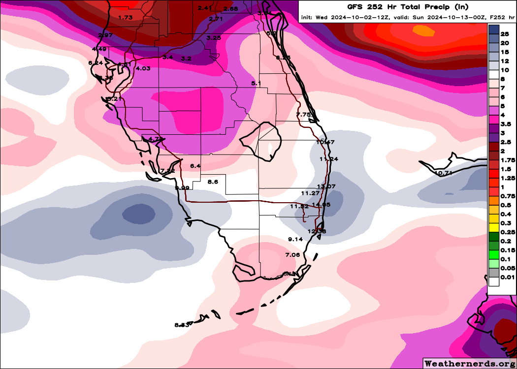
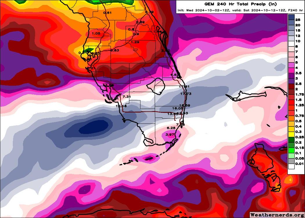
https://i.postimg.cc/wvSXgnmF/nnn.png
https://i.postimg.cc/RVx7859Z/nnnn.png
Let's hope the rain from the low that that wxman mentioned isn't too much and hope it moves out fast. I have an Aunt and Uncle who live in south Florida who keep calling me asking me about the disturbance. I keep telling them, it's too early to know for sure, but expect to maybe get very wet, that's all we know right now.
0 likes
-
toad strangler
- S2K Supporter
- Posts: 4546
- Joined: Sun Jul 28, 2013 3:09 pm
- Location: Earth
- Contact:
Re: Possible development in the Gulf of Mexico (0/40)
ConvergenceZone wrote:SFLcane wrote:wxman57 wrote:Still looks like only a frontal low. NE wind offshore 25-35 mph Sun-Tue. No wind inland. Some rain for south FL.
Just some rain for South Florida.
Even non-named systems can have big impacts!
https://i.postimg.cc/wvSXgnmF/nnn.png
https://i.postimg.cc/RVx7859Z/nnnn.png
Let's hope the rain from the low that that wxman mentioned isn't too much and hope it moves out fast.
Since you are mentioning hope, NOPE, not in agreement. The Dry Season looms on the FL peninsula very soon after this event and my area will take all it can get. Especially if there is no wind and surge for the FL west coast to worry about. That’s my “hope”
0 likes
My Weather Station
https://www.wunderground.com/dashboard/pws/KFLPORTS603
https://www.wunderground.com/dashboard/pws/KFLPORTS603
Who is online
Users browsing this forum: No registered users and 192 guests