ATL: KIRK - Post-Tropical - Discussion
Moderator: S2k Moderators
-
Sciencerocks
- Category 5

- Posts: 10193
- Age: 40
- Joined: Thu Jul 06, 2017 1:51 am
-
cheezyWXguy

- Category 5
- Posts: 6282
- Joined: Mon Feb 13, 2006 12:29 am
- Location: Dallas, TX
Re: ATL: KIRK - Hurricane - Discussion
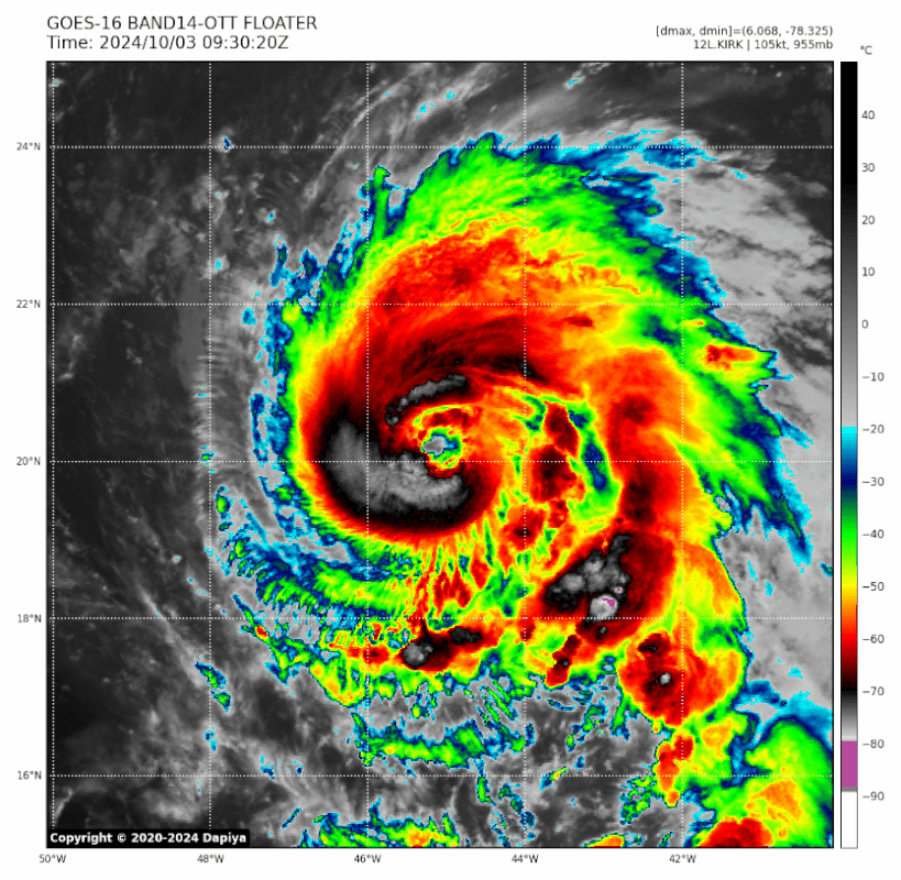
I get the impression from satellite that an erc is in the cards soon. The periodic dry slots immediately outside the eyewall suggest a double eyewall structure is probably in its formative stages.
1 likes

Re: ATL: KIRK - Hurricane - Discussion
cheezyWXguy wrote:I get the impression from satellite that an erc is in the cards soon. The periodic dry slots immediately outside the eyewall suggest a double eyewall structure is probably in its formative stages.
I was just looking at the microwave pass from a few hours ago thinking the same thing. Looks like an outer eyewall is starting to build up in the north, a ways to go before they reach all the way around. It could also end up being an eyewall meld situation, but looking at the 37Ghz it seems the outer eyewall is starting to wrap up around the SW.
 |  |
Sidenote: I picked the wrong day to get busy and not check up on Kirk
7 likes

Re: ATL: KIRK - Hurricane - Discussion
Hopefully Kirk holds up its presentation for another hour so it can get classified as a Cat 4. It’s probably 115-120 kt right now, but it won’t be long before the impending EWRC takes hold.
2 likes
Irene '11 Sandy '12 Hermine '16 5/15/2018 Derecho Fay '20 Isaias '20 Elsa '21 Henri '21 Ida '21
I am only a meteorology enthusiast who knows a decent amount about tropical cyclones. Look to the professional mets, the NHC, or your local weather office for the best information.
I am only a meteorology enthusiast who knows a decent amount about tropical cyclones. Look to the professional mets, the NHC, or your local weather office for the best information.

Re: ATL: KIRK - Hurricane - Discussion
held at 110kt for 18z:
AL, 12, 2024100318, , BEST, 0, 207N, 463W, 110, 948, HU
0 likes
Re: ATL: KIRK - Hurricane - Discussion
Travorum wrote:held at 110kt for 18z:AL, 12, 2024100318, , BEST, 0, 207N, 463W, 110, 948, HU
Getting flashbacks to the under-estimated EPac systems. This was likely a Cat 4 earlier today, hopefully it improves just enough for an upgrade at 11.
4 likes
Irene '11 Sandy '12 Hermine '16 5/15/2018 Derecho Fay '20 Isaias '20 Elsa '21 Henri '21 Ida '21
I am only a meteorology enthusiast who knows a decent amount about tropical cyclones. Look to the professional mets, the NHC, or your local weather office for the best information.
I am only a meteorology enthusiast who knows a decent amount about tropical cyclones. Look to the professional mets, the NHC, or your local weather office for the best information.
-
Hurricane2022

- Category 5
- Posts: 2092
- Joined: Tue Aug 23, 2022 11:38 pm
- Location: Araçatuba, Brazil
Re: ATL: KIRK - Hurricane - Discussion
Looks like C5 is again a real possibility 


6 likes
Sorry for the bad English sometimes...!
For reliable and detailed information for any meteorological phenomenon, please consult the National Hurricane Center, Joint Typhoon Warning Center , or your local Meteo Center.
--------
ECCE OMNIA NOVA FACIAM (Ap 21,5).
For reliable and detailed information for any meteorological phenomenon, please consult the National Hurricane Center, Joint Typhoon Warning Center , or your local Meteo Center.
--------
ECCE OMNIA NOVA FACIAM (Ap 21,5).
-
Sciencerocks
- Category 5
- Posts: 10193
- Age: 40
- Joined: Thu Jul 06, 2017 1:51 am

-
Sciencerocks
- Category 5
- Posts: 10193
- Age: 40
- Joined: Thu Jul 06, 2017 1:51 am
Re: ATL: KIRK - Hurricane - Discussion
Probably 125 knts but is heading towards cat5. Of course the nhc will keep it as a cat3 for some reason.
4 likes


Re: ATL: KIRK - Hurricane - Discussion
The loop has missing frames, but still. it's remarkable how quickly Kirk recovered once the dry air was gone:
4 likes
TC naming lists: retirements and intensity
Most aggressive Advisory #1's in North Atlantic (cr. kevin for starting the list)
Most aggressive Advisory #1's in North Atlantic (cr. kevin for starting the list)
Re: ATL: KIRK - Hurricane - Discussion
Ah yes, a 110 kt Cat 3.
6 likes
Irene '11 Sandy '12 Hermine '16 5/15/2018 Derecho Fay '20 Isaias '20 Elsa '21 Henri '21 Ida '21
I am only a meteorology enthusiast who knows a decent amount about tropical cyclones. Look to the professional mets, the NHC, or your local weather office for the best information.
I am only a meteorology enthusiast who knows a decent amount about tropical cyclones. Look to the professional mets, the NHC, or your local weather office for the best information.
-
WaveBreaking

- Category 2

- Posts: 728
- Joined: Sun Jun 30, 2024 11:33 am
- Location: US
Re: ATL: KIRK - Hurricane - Discussion

3 likes
I am NOT a professional meteorologist, so take all of my posts with a grain of salt. My opinions are mine and mine alone.
Re: ATL: KIRK - Hurricane - Discussion
aspen wrote:
Ah yes, a 110 kt Cat 3.
Best NHC can do is 115kt:
Hurricane Kirk Advisory Number 18
NWS National Hurricane Center Miami FL AL122024
500 PM AST Thu Oct 03 2024
...KIRK STRENGTHENS INTO A CATEGORY 4 MAJOR HURRICANE...
...LARGE SWELLS COULD REACH THE U.S. EAST COAST BY SUNDAY...
SUMMARY OF 500 PM AST...2100 UTC...INFORMATION
----------------------------------------------
LOCATION...21.1N 46.7W
ABOUT 1085 MI...1745 KM ENE OF THE NORTHERN LEEWARD ISLANDS
ABOUT 1655 MI...2665 KM SW OF THE AZORES
MAXIMUM SUSTAINED WINDS...130 MPH...215 KM/H
PRESENT MOVEMENT...NW OR 315 DEGREES AT 12 MPH...19 KM/H
MINIMUM CENTRAL PRESSURE...945 MB...27.91 INCHES
2 likes
Re: ATL: KIRK - Hurricane - Discussion
Travorum wrote:aspen wrote:
Ah yes, a 110 kt Cat 3.
Best NHC can do is 115kt:Hurricane Kirk Advisory Number 18
NWS National Hurricane Center Miami FL AL122024
500 PM AST Thu Oct 03 2024
...KIRK STRENGTHENS INTO A CATEGORY 4 MAJOR HURRICANE...
...LARGE SWELLS COULD REACH THE U.S. EAST COAST BY SUNDAY...
SUMMARY OF 500 PM AST...2100 UTC...INFORMATION
----------------------------------------------
LOCATION...21.1N 46.7W
ABOUT 1085 MI...1745 KM ENE OF THE NORTHERN LEEWARD ISLANDS
ABOUT 1655 MI...2665 KM SW OF THE AZORES
MAXIMUM SUSTAINED WINDS...130 MPH...215 KM/H
PRESENT MOVEMENT...NW OR 315 DEGREES AT 12 MPH...19 KM/H
MINIMUM CENTRAL PRESSURE...945 MB...27.91 INCHES
At least they went higher than the 18z BT.
5 likes
Irene '11 Sandy '12 Hermine '16 5/15/2018 Derecho Fay '20 Isaias '20 Elsa '21 Henri '21 Ida '21
I am only a meteorology enthusiast who knows a decent amount about tropical cyclones. Look to the professional mets, the NHC, or your local weather office for the best information.
I am only a meteorology enthusiast who knows a decent amount about tropical cyclones. Look to the professional mets, the NHC, or your local weather office for the best information.
-
cheezyWXguy
- Category 5
- Posts: 6282
- Joined: Mon Feb 13, 2006 12:29 am
- Location: Dallas, TX
Re: ATL: KIRK - Hurricane - Discussion
Kirk’s current appearance is a pretty spot on comparison to Lorenzo’s when it was upgraded to cat5. Eye and cdo temps look to be very close if not exactly the same. If this maintains I assume the NHC will be more generous at the 11PM update
5 likes
Re: ATL: KIRK - Hurricane - Discussion
Regardless of whether NHC is underestimating its currently intensity (which I think is true), Kirk is now officially the easternmost Category 4 hurricane in October, at 46.7W. It also broke the old record (Sam at 61.0W) by almost 15 degrees of longitude.
Kirk's current latitude at 21.1N may be beyond what some people would consider the MDR, but if you're a bit more lenient, it would also mean Kirk is the only October Category 4 hurricane in the MDR on record.
Kirk's current latitude at 21.1N may be beyond what some people would consider the MDR, but if you're a bit more lenient, it would also mean Kirk is the only October Category 4 hurricane in the MDR on record.
7 likes
TC naming lists: retirements and intensity
Most aggressive Advisory #1's in North Atlantic (cr. kevin for starting the list)
Most aggressive Advisory #1's in North Atlantic (cr. kevin for starting the list)
Re: ATL: KIRK - Hurricane - Discussion
cheezyWXguy wrote:Kirk’s current appearance is a pretty spot on comparison to Lorenzo’s when it was upgraded to cat5. Eye and cdo temps look to be very close if not exactly the same. If this maintains I assume the NHC will be more generous at the 11PM update
As many have pointed out, the NHC is a lot more conservative with upgrades and intensity estimates in the absence of recon in the last few years, part of which seems to be due to ADT becoming a lot worse for some reason. I highly doubt Lorenzo would’ve been upgraded to a Cat 5 if it occurred now; I also kinda doubt it even was one.
There’s just been this odd trend of the NHC going under with storms like this, placing them as high-end 3s or low-end 4s when other aspects of their appearance (eye temp/clearing, stadium effect, duration of appearance, comparison to similar storms with recon, etc) support at least a mid-range 4.
3 likes
Irene '11 Sandy '12 Hermine '16 5/15/2018 Derecho Fay '20 Isaias '20 Elsa '21 Henri '21 Ida '21
I am only a meteorology enthusiast who knows a decent amount about tropical cyclones. Look to the professional mets, the NHC, or your local weather office for the best information.
I am only a meteorology enthusiast who knows a decent amount about tropical cyclones. Look to the professional mets, the NHC, or your local weather office for the best information.

Re: ATL: KIRK - Hurricane - Discussion
It looks like Kirk might actually be trying to become a cat 5. Its satellite presentation is starting to approach perfection with a thick cold CDO which is somehow cooling rapidly over the last hour (average CDO temperature has decreased by 4 degrees in only 1 hour). Furthermore, the eye has continued to warm to +17.2C. CI# is still 'only' at 6.4 which translates to an intensity of 934mb/125kt. However, raw T# has shot up to 6.8, which would indicate a 135kt hurricane. If there isn't an EWRC I can realistically see Kirk reaching T# of 7.0 which would usually indicate a cat 5. Let's see what happens.


5 likes
Who is online
Users browsing this forum: No registered users and 71 guests